From Surf Wiki (app.surf) — the open knowledge base
Kalinga (province)
Province in Cordillera, Philippines

Province in Cordillera, Philippines
| Field | Value |
|---|---|
| name | Kalinga |
| settlement_type | |
| image_skyline | {{Photomontage |
| photo1a | Bum-bagRiceTerraces80420acg.jpg |
| photo2a | PasilRiverValley81023acg.jpg |
| photo2b | Lubuagan0552.jpg |
| photo3a | Tinglayan80427cg.jpg |
| photo3b | Binubulauan02.jpg |
| photo4a | Tabuk-Enrile Road, Bulanao (Tabuk, Kalinga; 04-27-2024).jpg |
| size | 250 |
| spacing | 2 |
| color | transparent |
| border | 0 |
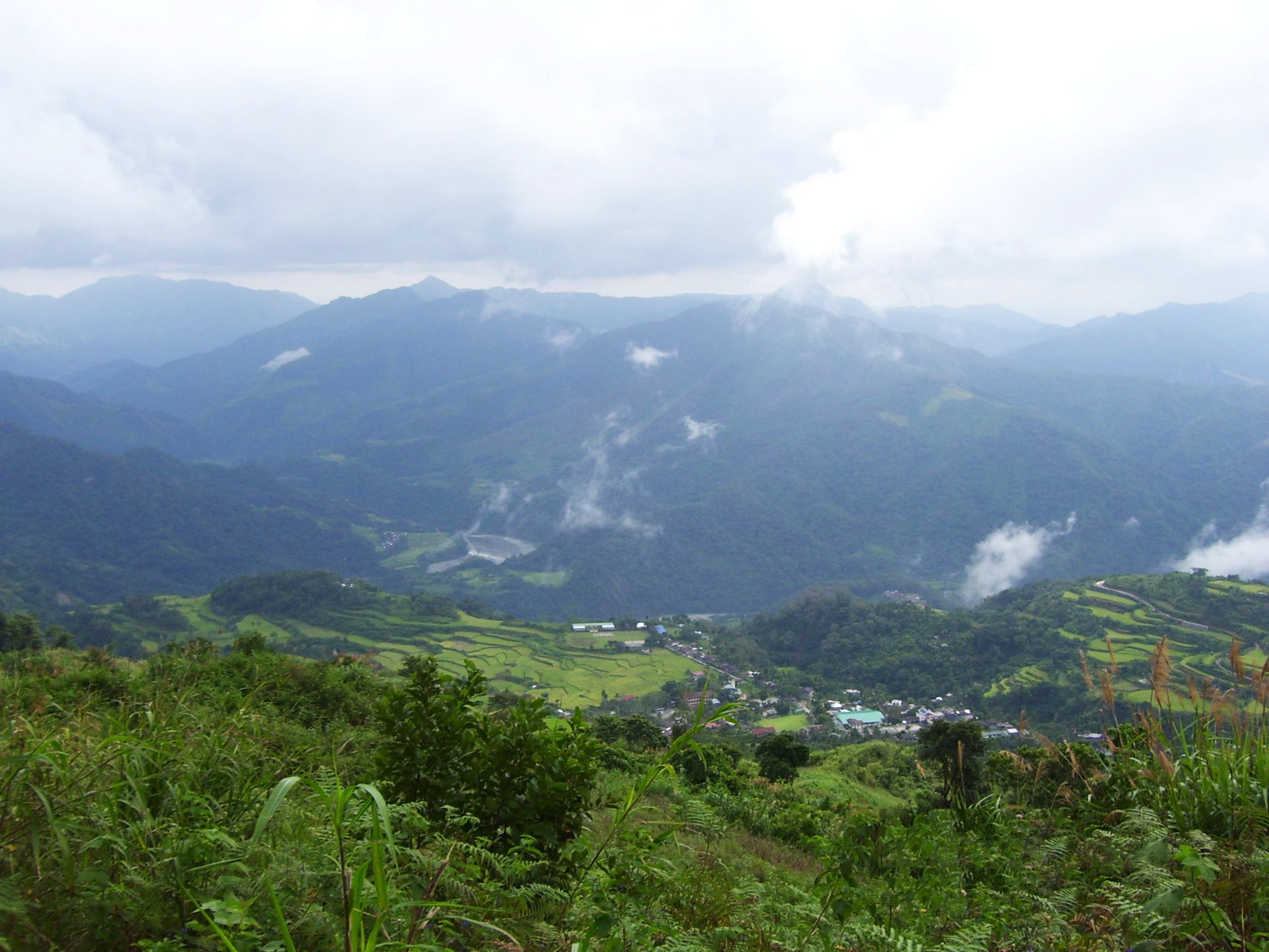
| image_caption | (from top: left to right) Bum-bag Rice Terraces, Pasil Valley, Lubuagan Mountains, Mount Manting-oy, Mount Binuluan and Bulanao in Tabuk City |
| image_flag | PH-KAL Flag.png |
| flag_size | 100x80px |
| image_seal | |
| seal_size | 100x80px |
| image_map | |
| map_caption | Location in the Philippines |
| coordinates | |
| subdivision_type | Country |
| subdivision_name | |
| subdivision_type1 | Region |
| subdivision_name1 | |
| established_title | Founded |
| established_date | May 8, 1995 |
| seat_type | Capital |
| and largest city | |
| seat | Tabuk |
| leader_title | Governor |
| leader_name | James S. Edduba (Lakas) |
| leader_title1 | Vice Governor |
| leader_name1 | Jocel C. Baac (Aksyon) |
| leader_title2 | Legislature |
| leader_name2 | Kalinga Provincial Board |
| area_footnotes | |
| area_total_km2 | |
| area_rank | 41st out of 82 |
| elevation_max_m | 2,617 |
| elevation_max_point | Mount Alchan |
| population_footnotes | |
| population_total | |
| population_as_of | |
| population_est | 220,329 |
| pop_est_as_of | 2020 |
| population_rank | 71st out of 82 |
| population_density_km2 | auto |
| population_density_rank | 78th out of 82 |
| population_demonym | |
| demographics_type1 | Divisions |
| demographics1_title1 | Independent cities |
| demographics1_info1 | 0 |
| demographics1_title2 | Component cities |
| demographics1_info2 | {{Collapsible list |
| titlestyle | font-weight:normal;text-align:left;background-color:WhiteSmoke; |
| title | 1 |
| demographics1_title3 | Municipalities |
| demographics1_info3 | {{Collapsible list |
| titlestyle | font-weight:normal;text-align:left;background-color:WhiteSmoke; |
| title | 7 |
| demographics1_title4 | Barangays |
| demographics1_info4 | 153 |
| demographics1_title5 | Districts |
| demographics1_info5 | Legislative district of Kalinga |
| timezone | PHT |
| utc_offset | +8 |
| postal_code_type | ZIP code |
| postal_code | |
| area_code_type | |
| area_code | |
| iso_code | |
| blank_name_sec1 | Spoken languages |
| blank_info_sec1 | |
| website | |
| short_description | Province of the Philippines |
| mapframe | yes |
| mapframe-zoom | 8 |
the province
and largest city | Tabuk | Balbalan | Lubuagan | Pasil | Pinukpuk | Rizal | Tanudan | Tinglayan | mapframe-zoom = 8
Kalinga (), officially the Province of Kalinga (; ), is a landlocked province in the Philippines situated within the Cordillera Administrative Region in Luzon. Its capital (and largest city) is Tabuk and borders Mountain Province to the south, Abra to the west, Isabela to the east, Cagayan to the northeast, and Apayao to the north. Kalinga and Apayao are the result of the 1995 partitioning of the former province of Kalinga-Apayao which was seen to better service the respective needs of the various indigenous peoples in the area.
President Emilio Aguinaldo proclaimed Lubuagan town the seat of government for 73 days from March 6, 1900, to May 18, 1900, before finally fleeing to his last hideout in Palanan.
Etymology
The province's name is derived from the Ibanag and Gaddang noun "kalinga", which means "enemy", "fighter", or "headtaker".
History
American occupation
Kalinga was taken from Cagayan and Isabela provinces and established by the US Government through Philippine Commission Act No. 1642 on May 9, 1907, as a sub-province of Lepanto-Bontoc.
Kalinga was later organized as one of the sub-provinces of Mountain Province, created by Act No. 1876.
In the early years, the subprovince underwent series of territorial changes. Part of Kalinga was transferred to another sub-province Bontoc through Executive Order No. 53 in 1914. In the municipal district of Pinukpuk, barrios were moved to Balbalan in 1926; as well as parts of it to Conner in Apayao in 1927.
Postwar era
Kalinga became part of a province along with Apayao when the old Mountain Province was divided into four separate provinces through Republic Act No. 4695 in 1966. Tabuc (Tabuk) was designated as the capital of Kalinga.
During the Marcos dictatorship
The beginning months of the 1970s marked a period of turmoil and change in the Philippines, as well as in Kalinga-Apayao. During his bid to be the first Philippine president to be re-elected for a second term, Ferdinand Marcos launched an unprecedented number of public works projects. This caused the Philippine economy took a sudden downwards turn known as the 1969 Philippine balance of payments crisis, which in turn led to a period of economic difficulty and social unrest.
With only a year left in his last constitutionally allowed term as president Ferdinand Marcos placed the Philippines under Martial Law in September 1972 and thus retained the position for fourteen more years. This period in Philippine history is remembered for the Marcos administration's record of human rights abuses, particularly targeting political opponents, student activists, journalists, religious workers, farmers, and others who fought against the Marcos dictatorship. The Kalinga-Apayao became known as a flashpoint of conflict between the Marcos dictatorship and the various indigenous peoples who lived in the area, because of the Chico River Dam Project, which, even if only the most essential part of it were built, would have encompassed the municipalities of Tinglayan, Lubuagan, Pasil, and parts of Tabuk in Kalinga, as well as numerous municipalities in Mountain Province; and would have displaced about 100,000 indigenous people. Because the great value placed on deceased ancestors who were buried within these communities, the issue was not just one of livelihood, but also one of sacred grounds. Marcos sent three armed brigades to quell down the protests, resulting in heightened tensions in the area. In 1977 alone, numerous Kalinga dam protesters — including tribal leaders Lumbaya Aliga Gayudan and Macli-ing Dulag, and even a 12-year-old child — were rounded up by these forces and incarcerated for up to two months.
The 24 April 1980 murder of Macli-ing Dulag became a turning point when coverage of the murder led to public outrage. It was the first time since the 1972 declaration of Martial Law where the mainstream Philippine press managed to report on the arrests of civilians under Martial Law, and the turn of public opinion against both the Chico River Dam and Martial law, coupled with the united anger of the various peoples of the Cordillera Mountains led the Ferdinand Marcos administration to give up on the dam project. As a result, the Chico River Dam Project is now considered a landmark case study concerning ancestral domain issues in the Philippines.
After the People Power Revolution
After Marcos' 21 years in power were finally ended by the civilian-led People Power Revolution in 1986, many of the activists who had joined the underground movement decided to "surface," as the new administration of Corazon Aquino released political prisoners and initiated peace talks. However, anti-left sentiment in Aquino's new cabinet, which included figures who were aligned with the Reform the Armed Forces Movement, made the peace process difficult, and negotiations eventually collapsed, and the insurgency in Kalinga-Apayao persisted.
Another event in 1986 marked the beginning of political change in the region, however - the splitting of the Cordillera People's Liberation Army from the New People's Army. Former Catholic priest Conrado Balweg, who had left his calling and joined the NPA in 1979, had been having disagreements with the NPA leadership over tactics and objectives in the Cordillera for four years when he finally decided to split from the NPA in early April 1986, believing that Igorot interests were better served through regional struggles for liberation, rather than the national-scale conflict pursued by the NPA.
Peace accord and creation of the Cordillera Autonomous Region
In September 1986, the CPLA signed the Mount Data Peace Accord with the government, which led to the creation of what became called the Cordillera Autonomous Region, although attempts to ratify actual autonomy in the region have failed due to non-ratification during plebiscites.
Along with Abra, Kalinga-Apayao became part of the territories in the Cordillera Administrative Region which was created through Executive Order No. 220 in 1987.
Creation as a province
Kalinga was converted into a province on May 8, 1995 by virtue of RA No. 7878 when a majority of the voters in Kalinga-Apayao approved in a plebiscite the division of the province into two.
Contemporary
The capital town Tabuk became a component city by virtue of Republic Act No. 9404 which sought to convert the town into a city. The law was ratified on June 23, 2007. However, the cityhood status was lost twice in the years 2008 and 2010 after the League of Cities of the Philippines questioned the validity of the cityhood law. The cityhood status was reaffirmed after the Supreme Court of the Philippines finalized its ruling on February 15, 2011 which declared the cityhood law constitutional.
Geography
Kalinga covers a total area of 3,231.25 km2 occupying the central section of the Cordillera Administrative Region in Luzon. The province is bordered by Mountain Province to the south, Abra to the west, Isabela to the east, Cagayan to the northeast, and Apayao to the north.
Large swaths of the province's lowlands are open grassland suitable for pasture, while the highlands have extensive areas of tropical rainforest. In higher elevations to the west, particularly in the mountains of Balbalan, lie some of the most intact pine forests of Luzon island. Rizal and Tabuk with their flatlands are the biggest rice producers. Next in rice production are the mountainous area, and of note are the rice terraces of Balbalan, Lubuagan, Pasil, Pinukpuk, Tinglayan, and Tanudan.
Climate
Kalinga features a Type III climate, characterized by a short, dry season from November to April and a relatively long wet season from May to October. Situated within the mountainous Cordillera Administrative Region, the province experiences average temperatures ranging from 17 to 22 degrees Celsius, though some areas can be warmer or cooler depending on altitude. It is prone to significant rainfall, particularly from July to October, with an average annual precipitation in some areas reaching around 1,755 mm.
Hydrology

The province is drained mainly by the Chico River, with its headwaters in the Mountain Province and emptying into the Cagayan River. The Chico River has several tributaries: Bunog River in Tinglayan in the south; the Tanudan and Biga Rivers in the east; Pasil River in the central area; and Poswoy, Dao-angan, Mabaca and Saltan Rivers in the west.
Several small lakes can also be found in Kalinga.
Administrative divisions

Kalinga comprises one component city and seven municipalities, all encompassed by a single legislative district.
Tabuk was proclaimed a component city in 2007, but in November 2008 the Supreme Court of the Philippines ruled that its cityhood was unconstitutional. However, Tabuk had its city status reinstated by the Supreme Court on December 22, 2009.

| City or municipality | Population | Area | Density | Barangay | (2020) | (2015) | km2 | sqmi | /km2 | /sqmi | Total | 229,570 | 212,680 | 3,282.04 | 3,231.25 km2 | {{sigfig | 229,570/3,231.25 | 2}} PD/km2 | 153 |
|---|---|---|---|---|---|---|---|---|---|---|---|---|---|---|---|---|---|---|---|
| Balbalan | 12,195 | 542.69 km2 | {{sigfig | 12,914/542.69 | 2}} PD/km2 | 14 | |||||||||||||
| Lubuagan | 8,733 | 234.20 km2 | {{sigfig | 9,323/234.20 | 2}} PD/km2 | 9 | |||||||||||||
| Pasil | 9,644 | 189.00 km2 | {{sigfig | 10,577/189.00 | 2}} PD/km2 | 14 | |||||||||||||
| Pinukpuk | 32,026 | 743.56 km2 | {{sigfig | 34,275/743.56 | 2}} PD/km2 | 23 | |||||||||||||
| Rizal | 17,038 | 281.79 km2 | {{sigfig | 19,554/281.79 | 2}} PD/km2 | 14 | |||||||||||||
| Tabuk | † | 110,642 | 700.25 km2 | {{sigfig | 121,033/700.25 | 2}} PD/km2 | 43 | ||||||||||||
| Tanudan | 9,534 | 307.55 km2 | {{sigfig | 8,746/307.55 | 2}} PD/km2 | 16 | |||||||||||||
| Tinglayan | 12,868 | 283.00 km2 | {{sigfig | 13,148/283.00 | 2}} PD/km2 | 20 | |||||||||||||
| Provincial capital and component city | Municipality |
Barangays
The seven municipalities and one component city of the province comprise 153 barangays, with Bulanao in Tabuk as the most populous in 2010, and Anggacan Sur in Tanudan as the least. If the City of Tabuk is excluded, Pinukpuk Junction in Pinukpuk municipality has the highest population.
Demographics
The population of Kalinga in the 2024 census was 235,391 people, with a density of {{sigfig|235,391/3,231.25|2}} PD/km2.
On the 2000 census survey, Kalinga people comprised of the total provincial population of 173,638. Ilocanos came in second at , while other ethnic groups in the province were the Kankanaey at , Bontoc at , Tagalog at and Applai at .
Languages
The primary language spoken in Kalinga is Kalinga, including its dialects of Balangao, Butbut, Limos, Lower Tanudan, Lubuagan, Mabaka, Madukayang, Southern Kalingan, and Upper Tanudan. Gaddang, as well as Ilocano, Tagalog, and English are also spoken in as lingua francas with varying degrees of proficiency.
Economy
Culture


There are many sub-tribes in the province. The strong sense of tribal membership and filial loyalty results in frequent tribal unrest and occasional outright war. Due to the mountainous terrain and warrior-culture of the people, the Kalinga were able to preserve their culture despite centuries of occupation in the lowlands by the Spaniards, Americans, and the Japanese.
On February 22, 2019, the Department of Tourism announced the bid of Digdiga Ni Tupayya, a Kalinga courtship dance, to be included in the UNESCO Intangible Cultural Heritage Lists.
Notable people
- Macli-ing Dulag - a Kalinga warrior and leader (pangat) who opposed the Chico River Dam Project and was killed by military personnel during martial law.
- Conrado Balweg - a former Catholic priest and founder of the Cordillera People's Liberation Army
- Whang-od - a Kalinga master tattooist (mambabatok) and recipient of the prestigious Dangal ng Haraya Award.
- Alonzo Saclag - Awarded as a National Living Treasure for his efforts to preserve the culture of Kalinga through performing arts.
- Jean Claude Saclag - martial artist
- Raffy Tima - newscaster, journalist
References
References
- "List of Provinces". National Statistical Coordination Board.
- (August 27, 2020). "POPULATION PROJECTIONS BY REGION, PROVINCE, CITIES AND MUNICIPALITIES, 2020-2025". Department of Health.
- "History".
- "Municipality of Lubuagan".
- "Archived copy".
- (May 9, 1907). "Act No. 1642". [[Government of the Philippines]].
- (2011–2012). "Index to Official Gazette (1913–1928)". [[The Library Corporation]].
- (June 18, 1966). "Republic Act No. 4695". Arellano Law Foundation.
- "The Manolay cult: The genesis and dissolution of millenarian sentiments among the Isneg of Northern Luzon". [[University of the Philippines Diliman]].
- Robles, Raissa. (2016). "Marcos Martial Law: Never Again". Filipinos for a Better Philippines, Inc..
- Balbosa, Joven Zamoras. (1992). "IMF Stabilization Program and Economic Growth: The Case of the Philippines". Journal of Philippine Development.
- (2003). "The Philippine Economy: Development, Policies, and Challenges". Oxford University Press.
- Cororaton, Cesar B.. "Exchange Rate Movements in the Philippines". DPIDS Discussion Paper Series 97-05.
- Kessler, Richard J.. (1989). "Rebellion and repression in the Philippines". Yale University Press.
- Celoza, Albert F.. (1997). "Ferdinand Marcos and the Philippines: The Political Economy of Authoritarianism". Greenwood Publishing Group.
- Schirmer, Daniel B.. (1987). "The Philippines reader : a history of colonialism, neocolonialism, dictatorship, and resistance". South End Press.
- (1998). "Kasaysayan, The Story of the Filipino People Volume 9:A Nation Reborn.". Asia Publishing Company Limited.
- (September 20, 1999). "Alfred McCoy, Dark Legacy: Human rights under the Marcos regime". [[Ateneo de Manila University]].
- (2005). "State and society in the Philippines". Rowman & Littlefield Publishers.
- "Gone too soon: 7 youth leaders killed under Martial Law". Rappler.
- Doyo, Ma. Ceres P.. (2015). "Macli-ing Dulag: Kalinga Chief, Defender of the Cordillera". University of the Philippines Press.
- Joanna K. Cariño, "The Chico River Basin Development Project: A Case Study in National Development Policy," ''Aghamtao'' Vol. III (December 1980): 2, https://pssc.org.ph/wp-content/pssc-archives/Aghamtao/1980/05_The%20Chico%20River%20Basin%20Development%20Project_%20A%20Case%20Study%20in%20National%20Development%20Policy.pdf.
- (1980-09-05). "Valley of Sorrow".
- (1985). "The Philippine Press Under Siege II".
- Tauli-Corpuz, Victoria. (March 29, 2018). "A silent war is being waged on Philippine indigenous communities".
- "Where the Chico River Rumbles | Travel Inspirations | Yahoo! Singapore Travel".
- Jamias, Juan F (1975) Readings in Development Communication. College, Philippines : College of Agriculture, University of the Philippines Los Baños.
- Villegas, Bernardo M.. (1987-02-01). "The Philippines in 1986: Democratic Reconstruction in the Post-Marcos Era". Asian Survey.
- Curaming, Rommel and Claudio, Lisandro, A Historicised (Re)Assessment of EDSA 'People Power' (1986) (February 1, 2010). Asia Research Institute Working Paper No. 134. https://ssrn.com/abstract=1716572 or http://dx.doi.org/10.2139/ssrn.1716572
- Marchadesch, Barbara. (November 24, 2017). "TIMELINE: The peace talks between the government and the CPP-NPA-NDF, 1986 – present". GMA News Online.
- "Peace Process with the Cordillera Bodong Administration – Cordillera People's Liberation Army (CBA-CPLA)". [[Office of the Presidential Adviser on Peace, Reconciliation and Unity]].
- "Conrado Balweg - Priest, Guerrilla Leader and Politician".
- Amor, Patria. (February 4, 1990). "What now for Cordillera?". [[The Manila Standard]].
- Maragay, Fel V.. (1990-02-01). "Cordillerans reject autonomy proposal". [[Manila Standard]].
- (July 15, 1987). "Executive Order No. 220, s. 1987". [[Government of the Philippines]].
- "The Kalinga". [[Government of the Philippines]].
- (July 5, 1995). "Memorandum Order No. 290, s. 1995". [[Government of the Philippines]].
- (December 23, 2009). "SC reverses self, upholds creation of 16 cities". The Daily Tribune.
- (May 29, 2002). "Females Better Educated in Kalinga; Table 5. Household Population by Ethnicity and Sex: Kalinga, 2000".
- (February 22, 2019). "DOT eyes Kalinga courtship dance in UNESCO heritage list". Philippine News Agency.
- "DOT eyes Kalinga courtship dance in UNESCO heritage list".
This article was imported from Wikipedia and is available under the Creative Commons Attribution-ShareAlike 4.0 License. Content has been adapted to SurfDoc format. Original contributors can be found on the article history page.
Ask Mako anything about Kalinga (province) — get instant answers, deeper analysis, and related topics.
Research with MakoFree with your Surf account
Create a free account to save articles, ask Mako questions, and organize your research.
Sign up freeThis content may have been generated or modified by AI. CloudSurf Software LLC is not responsible for the accuracy, completeness, or reliability of AI-generated content. Always verify important information from primary sources.
Report