From Surf Wiki (app.surf) — the open knowledge base
Kalapani territory
Territory in dispute
,_1819.jpg)
Territory in dispute
| Field | Value | ||
|---|---|---|---|
| name | Kalapani territory | ||
| native_name_lang | |||
| settlement_type | Territory in dispute | ||
| image_size | 300px | ||
| pushpin_map | India Uttarakhand#Nepal Sudurpashchim Province | ||
| coordinates | |||
| coord | |||
| float | right | ||
| zoom | 11 | ||
| width | 250 | ||
| height | 250 | ||
| caption | |||
| nolabels | 1 | ||
| map-data | Q1499 | ||
| mark-coord1 | |||
| mark1 | Mountain pass 12x12 se.svg | ||
| mark-size1 | 12 | ||
| label1 | Lipulekh | labela1 = Pass | |
| label-size1 | 10 | ||
| label-color1 | hard red | ||
| label-pos1 | right | label-offset-x1 = 0 | label-offset-y1 = -5 |
| mark-title1 | Lipulekh Pass | ||
| mark-description1 | Point on China–India border | ||
| mark-coord2 | |||
| mark2 | Red pog.svg | ||
| mark-size2 | 6 | ||
| label2 | Kalapani | labela2 = village | |
| label-size2 | 10 | ||
| label-color2 | hard red | ||
| label-pos2 | bottom | label-offset-x2 = -8 | label-offset-y2 = 0 |
| mark-title2 | Kalapani village | ||
| mark-coord3 | |||
| mark3 | Red pog.svg | ||
| mark-size3 | 6 | ||
| label3 | camp | labela3=ground | |
| label-size3 | 10 | ||
| label-color3 | hard red | ||
| label-pos3 | top | label-offset-x3 = -15 | label-offset-y3 = 2 |
| mark-title3 | Kalapani camping ground | ||
| mark-coord4 | |||
| mark4 | Red pog.svg | ||
| mark-size4 | 6 | ||
| label4 | Gunji | ||
| label-size4 | 10 | ||
| label-color4 | hard red | ||
| label-pos4 | top | label-offset-x4 = 0 | label-offset-y4 = 0 |
| mark-title4 | Gunji | ||
| mark-coord5 | |||
| mark5 | Blue Fire.svg | ||
| mark-size5 | 12 | ||
| label5 | P. 6172 | ||
| label-size5 | 10 | ||
| label-color5 | hard blue | ||
| label-pos5 | bottom | label-offset-x5 = -4 | label-offset-y5 = 0 |
| mark-title5 | P. 6172 | ||
| mark-description5 | Peak on India–Nepal border (6,172 m) | ||
| mark-coord6 | |||
| mark6 | Blue Fire.svg | ||
| mark-size6 | 12 | ||
| label6 | Om Parvat | ||
| label-size6 | 10 | ||
| label-color6 | hard blue | ||
| label-pos6 | top | label-offset-x6 = -28 | label-offset-y6 = 5 |
| mark-title6 | Om Parvat | ||
| mark-description6 | Peak on India–Nepal border (5590 m) | ||
| mark-coord7 | |||
| mark7 | Mountain pass 12x12 ne.svg | ||
| mark-size7 | 12 | ||
| label7 | Tinkar | labela7 = Pass | |
| label-size7 | 10 | ||
| label-color7 | hard red | ||
| label-pos7 | right | label-offset-x7 = 0 | label-offset-y7 = -5 |
| mark-title7 | Tinkar Pass | ||
| mark-description7 | Mountain pass on China–Nepal border | ||
| mark-coord10 | |||
| mark10 | AS-rzeka-icon.svg | ||
| mark-size10 | 11 | ||
| label10 | Kalapani | labela10 = River | |
| label-size10 | 10 | ||
| label-color10 | hard blue | ||
| label-pos10 | right | label-offset-x10 = 0 | label-offset-y10 = -12 |
| mark-title10 | Kalapani River | ||
| mark-description10 | Also called Lipu Gad, headwater of Kali | ||
| mark-coord11 | |||
| mark11 | AS-rzeka-icon.svg | ||
| mark-size11 | 11 | ||
| label11 | Lipu | labela11 = Gad | |
| label-size11 | 10 | ||
| label-color11 | hard blue | ||
| label-pos11 | top | label-offset-x11 = -5 | label-offset-y11 = 0 |
| mark-title11 | Lipu Gad | ||
| mark-description11 | Upper stream of the Kalapani River | ||
| mark-coord12 | |||
| mark12 | AS-rzeka-icon.svg | ||
| mark-size12 | 11 | ||
| label12 | Lilinthi | labela12 = Gad | |
| label-size12 | 10 | ||
| label-color12 | hard blue | ||
| label-pos12 | right | label-offset-x12 = 0 | label-offset-y12 = -5 |
| mark-title12 | Lilinthi Gad | ||
| mark-description12 | Tributary of the Kalapani River | ||
| mark-coord13 | |||
| mark13 | AS-rzeka-icon.svg | ||
| mark-size13 | 11 | ||
| label13 | Pankha | labela13 = Gad | |
| label-size13 | 10 | ||
| label-color13 | hard blue | ||
| label-pos13 | right | label-offset-x13 = 0 | label-offset-y13 = -5 |
| mark-title13 | Pankha Gad | ||
| mark-description13 | Tributary of the Kalapani River | ||
| mark-coord14 | |||
| mark14 | AS-rzeka-icon.svg | ||
| mark-size14 | 11 | ||
| label14 | Tera | labela14 = Gad | |
| label-size14 | 10 | ||
| label-color14 | hard blue | ||
| label-pos14 | right | label-offset-x14 = 0 | label-offset-y14 = -5 |
| mark-title14 | Tera Gad | ||
| mark-description14 | Tributary of the Kalapani River | ||
| mark-coord20 | |||
| mark20 | red pog.svg | ||
| mark-size20 | 0 | ||
| label20 | KUMAON | labela20 = (INDIA) | |
| label-size20 | 14 | ||
| label-color20 | dark grey | ||
| label-pos20 | top | label-offset-x20 = 0 | label-offset-y20 = 0 |
| mark-title20 | Kumaon | ||
| mark-description20 | Part of Uttarakhand | ||
| mark-coord21 | |||
| mark21 | red pog.svg | ||
| mark-size21 | 0 | ||
| label21 | NEPAL | ||
| label-size21 | 14 | ||
| label-color21 | dark grey | ||
| label-pos21 | top | label-offset-x21 = 0 | label-offset-y21 = 0 |
| mark-title21 | Nepal | ||
| mark-coord22 | |||
| mark22 | red pog.svg | ||
| mark-size22 | 0 | ||
| label22 | TIBET | labela22 = (CHINA) | |
| label-size22 | 14 | ||
| label-color22 | dark grey | ||
| label-pos22 | top | label-offset-x22 = 0 | label-offset-y22 = 0 |
| mark-title22 | Tibet | ||
| mark-description22 | Autonomous region of China | ||
| subdivision_type | Country | ||
| subdivision_name | India | ||
| Disputed by Nepal | |||
| established_title | Established | ||
| established_date | |||
| founder | British Raj | ||
| government_type | Border security | ||
| governing_body | Indo-Tibetan Border Police | ||
| unit_pref | Metric | ||
| area_footnotes | |||
| area_total_km2 | 35 | ||
| elevation_max_footnotes | |||
| elevation_max_m | 6180 | ||
| elevation_min_m | 3650 | ||
| population_total | 50–100 | ||
| utc_offset1 | +5:30 | ||
| website |
| map-data = Q1499
| mark-coord1 =
| mark-size1 = 12
| label-size1 = 10
| label-color1 = hard red
| label-pos1 = right | label-offset-x1 = 0 | label-offset-y1 = -5
| mark-title1 = Lipulekh Pass
| mark-description1 = Point on China–India border
| mark-coord2 =
| mark-size2 = 6
| label-size2 = 10
| label-color2 = hard red
| label-pos2 = bottom |label-offset-x2 = -8 |label-offset-y2 = 0
| mark-title2 = Kalapani village
| mark-description2 =
| mark-coord3 =
| mark-size3 = 6
| label-size3 = 10
| label-color3 = hard red
| label-pos3 = top |label-offset-x3 = -15 |label-offset-y3 = 2
| mark-title3 = Kalapani camping ground
| mark-description3 =
| mark-coord4 =
| mark-size4 = 6
| label-size4 = 10
| label-color4 = hard red
| label-pos4 = top |label-offset-x4 = 0 |label-offset-y4 = 0
| mark-title4 = Gunji
| mark-description4 =
| mark-coord5 =
| mark-size5 = 12
| label-size5 = 10
| label-color5 = hard blue
| label-pos5 = bottom |label-offset-x5 = -4 |label-offset-y5 = 0
| mark-title5 = P. 6172
| mark-description5 = Peak on India–Nepal border (6,172 m)
| mark-coord6 =
| mark-size6 = 12
| label-size6 = 10
| label-color6 = hard blue
| label-pos6 = top |label-offset-x6 = -28 |label-offset-y6 = 5
| mark-title6 = Om Parvat
| mark-description6 = Peak on India–Nepal border (5590 m)
| mark-coord7 =
| mark-size7 = 12
| label-size7 = 10
| label-color7 = hard red
| label-pos7 = right |label-offset-x7 = 0 |label-offset-y7 = -5
| mark-title7 = Tinkar Pass
| mark-description7 = Mountain pass on China–Nepal border
| mark-coord10 =
| mark-size10 = 11
| label-size10 = 10
| label-color10 = hard blue
| label-pos10 = right |label-offset-x10 = 0 |label-offset-y10 = -12
| mark-title10 = Kalapani River
| mark-description10= Also called Lipu Gad, headwater of Kali
| mark-coord11 =
| mark-size11 = 11
| label-size11 = 10
| label-color11 = hard blue
| label-pos11 = top |label-offset-x11 = -5 |label-offset-y11 = 0
| mark-title11 = Lipu Gad
| mark-description11 = Upper stream of the Kalapani River
| mark-coord12 =
| mark-size12 = 11
| label-size12 = 10
| label-color12 = hard blue
| label-pos12 = right |label-offset-x12 = 0 |label-offset-y12 = -5
| mark-title12 = Lilinthi Gad
| mark-description12 = Tributary of the Kalapani River
| mark-coord13 =
| mark-size13 = 11
| label-size13 = 10
| label-color13 = hard blue
| label-pos13 = right |label-offset-x13 = 0 |label-offset-y13 = -5
| mark-title13 = Pankha Gad
| mark-description13 = Tributary of the Kalapani River
| mark-coord14 =
| mark-size14 = 11
| label-size14 = 10
| label-color14 = hard blue
| label-pos14 = right |label-offset-x14 = 0 |label-offset-y14 = -5
| mark-title14 = Tera Gad
| mark-description14 = Tributary of the Kalapani River
| mark-coord20 =
| mark-size20 = 0
| label-size20 = 14
| label-color20 = dark grey
| label-pos20 = top |label-offset-x20 = 0 |label-offset-y20 = 0
| mark-title20 = Kumaon
| mark-description20 = Part of Uttarakhand
| mark-coord21 =
| mark-size21 = 0
| label-size21 = 14
| label-color21 = dark grey
| label-pos21 = top |label-offset-x21 = 0 |label-offset-y21 = 0
| mark-title21 = Nepal
| mark-description21 =
| mark-coord22 =
| mark-size22 = 0
| label-size22 = 14
| label-color22 = dark grey
| label-pos22 = top |label-offset-x22 = 0 |label-offset-y22 = 0
| mark-title22 = Tibet
| mark-description22 = Autonomous region of China
Disputed by Nepal
tags --
The Kalapani territory is an area under Indian administration as part of Pithoragarh district in the Kumaon Division of the Uttarakhand state,
K. C. Sharad, Kalapani's new 'line of control', Nepali Times, 10 September 2004, p. 6
but it is also claimed by Nepal since 1997.
Ramananda Sengupta, Akhilesh Upadhyay, In Dark Waters, Outlook, 20 July 1998.
According to Nepal's claim, it lies in Darchula district, Sudurpashchim Province.
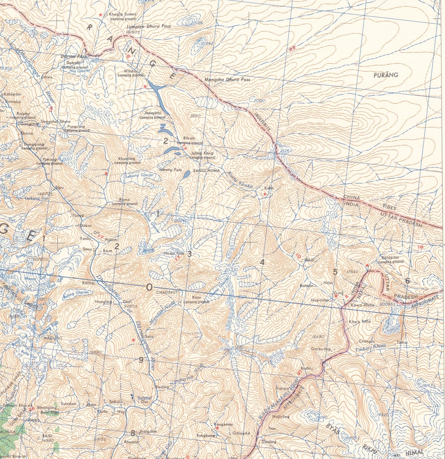
The territory represents part of the basin of the Kalapani river, one of the headwaters of the Kali River in the Himalayas at an altitude of 3600–5200 meters. The valley of Kalapani, with the Lipulekh Pass at the top, forms the Indian route to Kailash–Manasarovar, an ancient pilgrimage site. It is also the traditional trading route to Tibet for the Bhotiyas of Kumaon and the Tinkar valley of Nepal.
The Kali River forms the boundary between India and Nepal in this region. However, India states that the headwaters of the river are not included in the boundary. Here the border runs along the watershed. This is a position dating back to British India .
Nepal has another pass, the Tinkar Pass (or "Tinkar Lipu"), close to the area. After India closed the Lipulekh Pass in the aftermath of the 1962 Sino-Indian War, much of the Bhotiya trade used to pass through the Tinkar Pass. The Nepalese protests regarding the Kalapani territory started in 1997, after India and China agreed to reopen the Lipulekh pass. Since that time, Nepalese maps have shown the area up to the Kalapani river, measuring 35 square kilometres, as part of Nepal's Darchula District.
A joint technical committee of Indian and Nepalese officials have been discussing the issue since 1998, along with other border issues. But the matter has not yet been resolved.
On 20 May 2020, Nepal released a new map of its own territory that expanded its claim an additional 335 square kilometres up to the Kuthi Yankti river, including Kalapani, Lipulekh and Limpiyadhura. It did not explain why a new claim arose.
Geography and tradition
According to the Almora District Gazetteer (1911) "Kalapani" (literally, "dark water") is the name given to a remarkable collection of springs near the Kalapani village. The springs rise from the north-eastern declivity of a peak known as Byans-Rikhi at an elevation of 14220 ft and flow into a stream in the valley (elevation: 12,000 ft). The stream, bearing the name "Kalapani River", is formed from two streams, says the Gazetteer, one rising from the western end of the Lipulekh Pass (Lipu Gad) and another from the western declivity of the Kuntas peak (Tera Gad). Modern maps show two further streams joining from the southeast, which arise at the Om Parvat and Point 6172 respectively. The latter of these, called Pankha Gad, joins the river very near the Kalapani village.
The Gazetteer continues to state that the united stream of Kalapani flows five miles southwest, where it is joined by the Kuthi Yankti river that arises from the Limpiyadhura Pass (near the village of Gunji). After this union, the river is called the "Kali River". Language being not entirely logical, the term "Kali River" is often applied to the river from the location of the springs themselves. The springs are considered sacred by the people of the area and "erroneously" regarded as the origin of the Kali River. However, they had been regarded as a landmark by the British from the very first survey undertaken by W. J. Webb in 1816.
| map-data = Q1945425, Q1499
| mark-coord1 =
| mark-size1 = 10
| label-size1 = 10
| label-color1 = hard red
| label-pos1 = right | label-offset-x1 = 0 | label-offset-y1 = -5
| mark-title1 = Lipulekh Pass
| mark-description1 = Point on China–India border
| mark-coord2 =
| mark-size2 = 6
| label-size2 = 10
| label-color2 = hard red
| label-pos2 = left |label-offset-x2 = -2 |label-offset-y2 = 0
| mark-title2 = Kalapani village
| mark-description2 =
| mark-coord3 =
| mark-size3 = 6
| label-size3 = 10
| label-color3 = hard red
| label-pos3 = left |label-offset-x3 = 0 |label-offset-y3 = 0
| mark-title3 = Gunji
| mark-description3 =
| mark-coord4 =
| mark-size4 = 6
| label-size4 = 10
| label-color4 = hard red
| label-pos4 = right |label-offset-x4 = 0 |label-offset-y4 = 0
| mark-title4 = Kuthi
| mark-description4 =
| mark-coord5 =
| mark-size5 = 10
| label-size5 = 10
| label-color5 = hard red
| label-pos5 = right |label-offset-x5 = 2 |label-offset-y5 = -10
| mark-title5 = Limpiyadhura Pass
| mark-description5 = Point on China–India border
| mark-coord6 =
| mark-size6 = 6
| label-size6 = 10
| label-color6 = hard red
| label-pos6 = left |label-offset-x6 = -4 |label-offset-y6 = 0
| mark-title6 = Garbyang
| mark-description6 =
| mark-coord7 =
| mark-size7 = 10
| label-size7 = 10
| label-color7 = hard red
| label-pos7 = right |label-offset-x7 = 0 |label-offset-y7 = -5
| mark-title7 = Tinkar Pass
| mark-description7 = Mountain pass on China–Nepal border
| mark-coord8 =
| mark-size8 = 6
| label-size8 = 10
| label-color8 = hard red
| label-pos8 = top |label-offset-x8 = 17 |label-offset-y8 = 1
| mark-title8 = Changru
| mark-description8 =
| mark-coord9 =
| mark-size9 = 6
| label-size9 = 10
| label-color9 = hard red
| label-pos9 = right |label-offset-x9 = 0 |label-offset-y9 = 0
| mark-title9 = Tinkar
| mark-description9 =
| mark-coord10 =
| mark-size10 = 11
| label-size10 = 10
| label-color10 = hard blue
| label-pos10 = top |label-offset-x10 = 0 |label-offset-y10 = 0
| mark-title10 = Kalapani River
| mark-description10= Also called Lipu Gad, headwater of Kali
| mark-coord11 =
| mark-size11 = 11
| label-size11 = 10
| label-color11 = hard blue
| label-pos11 = left |label-offset-x11 = 0 |label-offset-y11 = -5
| mark-title11 = Kuthi Yankti
| mark-description11= Headwater of Kali
| mark-coord12 =
| mark-size12 = 11
| label-size12 = 10
| label-color12 = hard blue
| label-pos12 = bottom |label-offset-x12 = 0 |label-offset-y12 = 0
| mark-title12 = Tinkar Khola
| mark-description12 = Tributary of Kali in Nepal
| mark-coord13 =
| mark-size13 = 11
| label-size13 = 12
| label-color13 = hard blue
| label-pos13 = left |label-offset-x13 = 0 |label-offset-y13 = -5
| mark-title13 = Kali River
| mark-description13 = Sharda River in the hills
| mark-coord20 =
| mark-size20 = 0
| label-size20 = 14
| label-color20 = dark grey
| label-pos20 = top |label-offset-x20 = 0 |label-offset-y20 = 0
| mark-title20 = Kumaon
| mark-description20 = Part of Uttarakhand
| mark-coord21 =
| mark-size21 = 0
| label-size21 = 14
| label-color21 = dark grey
| label-pos21 = top |label-offset-x21 = 0 |label-offset-y21 = 0
| mark-title21 = Nepal
| mark-description21 =
| mark-coord22 =
| mark-size22 = 0
| label-size22 = 14
| label-color22 = dark grey
| label-pos22 = top |label-offset-x22 = 0 |label-offset-y22 = 0
| mark-title22 = Tibet
| mark-description22 = Autonomous region of China
The area on both sides of the Kali River is called Byans, which was a pargana (district in Mughal times). It is populated by Byansis, who speak a West Himalayish language (closely related to the Zhang-Zhung language once spoken in West Tibet). The Byansis practise transhumance, living in their traditional homes in the high Himalayas during the summer and moving down to towns such as Dharchula in the winter. While high-altitude pastoralism is the mainstay of the Byansis, trade with western Tibet was also a key part of their livelihood. Both the Limpiyadhura pass and the Lipulekh pass were frequently used by the Byansis, but the Lipulekh pass leading to the Tibetan trading town of Burang (or Taklakot) was the most popular.
To the southeast of the Kalapani river is the Tinkar valley (presently in Nepal), with large villages of Changru and Tinkar. This area is also populated by Byansis. They have another pass referred to as Tinkar Pass that leads to Burang.
History
Early 19th century

Following the Unification of Nepal under Prithvi Narayan Shah, Nepal attempted to enlarge its domains, conquering much of Sikkim in the east and, in the west, the basins of Gandaki and Karnali and the Uttarakhand regions of Garhwal and Kumaon. This brought them in conflict with the British, who controlled directly or indirectly the north Indian plains between Delhi and Calcutta. A series of campaigns termed the Anglo-Nepalese War occurred in 1814–1816. In 1815 the British general Ochterlony evicted the Nepalese from Garhwal and Kumaon across the Kali River, : "Ochterlony forced Amar Singh Thapa to agree at Malaun to terms under which the Nepali army retired with their arms, and the territory between the Kali and Sutlej rivers came under the control of the British." ending the 25-year rule of the region by Nepal.
Octherlony offered peace terms to the Nepalese demanding British oversight through a Resident and the delimitation of Nepal's territories corresponding roughly to its present-day boundaries in the east and west. The Nepalese refusal to accede to these terms led to another campaign the following year, targeting the Kathmandu Valley, after which the Nepalese capitulated. : "The Nepalese government initially balked at these terms, but agreed to ratify them in March 1816 after Ochterloney occupied the Makwanpur Valley only thirty miles from the capital." : "[In 1816] With the collapse of the main defense line, the Darbar quickly dispatched Chandra Sekhar Upadhyaya to Ochterlony's camp with a copy of the Sugauli treaty bearing the seal of the Maharaja."
The resulting agreement, the Sugauli Treaty, states in its Article 5: Even though the Article was meant to set Kali River as the boundary of Nepal, initially the British administrators retained control of the entire Byans region both to the east and west of the Kali/Kalapani river, stating that it had been traditionally part of Kumaon. In 1817, the Nepalese made a representation to the British, claiming that they were entitled to the areas to the east of Kali. After consideration, the British governor-general in council accepted the demand. The Byans region to the east of Kali was transferred to Nepal, dividing the Byans pargana across the two countries.
Not being satisfied with this, the Nepalese also extended a claim to the Kuthi valley further west, stating that the Kuthi Yankti stream, the western branch of the head waters, should be considered the main Kali River. Surveyor W. J. Webb and other British officials showed that the lesser stream flowing from the Kalapani springs "had always been recognised as the main branch of the Kali" and "had in fact given its name to the river". Consequently, the British Indian government retained the Kuthi valley. Letter of the Government of India to Commissioner of Kumaon, September 5, 1817. Included in Rakesh Sood, A Reset in India–Nepal Relations, blog post at rakeshsood.in with attachments for an article published in The Hindu, 29 May 2020. "Governor General entirely approves your having declined to transfer to the Chountra Bum Sah the two villages of Koontee and Nabee in Pergunah Byanse without the specific orders of the Government on the ground of their being situated to the west of the stream ordinarily recognized as the principal branch of the Kali in that quarter." (emphasis added)
Late 19th century
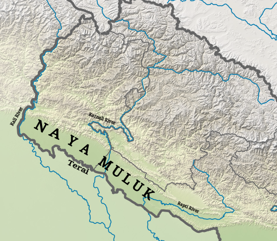
Some time around 1865, the British shifted the border near Kalapani to the watershed of the Kalapani river instead of the river itself, thereby claiming the area now called the Kalapani territory. This is consistent with the British position that the Kali River begins only from the Kalapani springs, which meant that the agreement of Sugauli did not apply to the region above the springs. Scholars Manandhar and Koirala believe that the shifting of the border was motivated by strategic reasons. The inclusion of the highest point in the region, Point 6172, provides an unhindered view of the Tibetan plateau. For Manandhar and Koirala, this represents an "unauthorized", "unilateral" move on the part of the British. However Nepal was effectively a British-protected state at that time, even though the British termed it an "independent state with special treaty relations". Around the same time that the British claimed the Kalapani territory, they had also ceded to Nepal the western Tarai regions, which were later named "Naya Muluk" ("New Lands") by Nepal. The addition of these regions was of significant economic benefit to Nepal.
- pp. 46–47: "In return, the British restored to Nepal the western Tarai, taken in 1816, and conferred an honorary knighthood on Jang [Bahadur Rana] himself."
- pp. 54–55: "... the Ranas secured a steady rise in state revenue, which rose from around 1.4 million rupees in 1850 to perhaps 12 million in 1900, a substantial rise even allowing for inflation. ... Particularly important was the return to Nepal in 1860 of the western Tarai districts, which were initially very sparsely populated." Nepal's boundaries had moved on from those of the Sugauli treaty.
20th century


In 1923, Nepal received recognition from the British as a completely independent state. In 1947, India acquired independence from their rule and became a republic. Nepal and India entered into a Treaty of Peace and Friendship in 1950, which had a strong element of mutual security alliance, mirroring the earlier treaties with British India.
No changes in India's border with Nepal are discernible from the maps of the period. The Kalapani territory continued to be shown as part of India. Following the Chinese take-over of Tibet in 1951, India increased its security presence along the northern border to inhibit possibilities of encroachment and infiltration. The Kalapani area is likely to have been included among such areas. : "... an elected member of the National Panchayat from Byas, Bahadur Singh Aitwal, says that Indian security forces were present in Kalapani from 1959." Nepal too requested India's help in policing its northern border as early as 1950, and 17 posts are said to have been established jointly by the two countries. Nepal Border Posts Abandoned by India, Daytona Beach Morning Journal, 29 December 1969.
Nepal expert Sam Cowan states that, from the date of its independence, India "has assumed and acted on the basis that the trail to Lipu Lekh fell exclusively within its territory". The 1954 Trade Agreement between India and China mentioned Lipulekh as one of the passes that could be used by Indo-Tibetan trade and pilgrimage traffic. Nepal was not mentioned in the Agreement. A State Police post was established at Kalapani in 1956, which remained in place till 1979, when it was replaced by Indo-Tibetan Border Police (ITBP).}}
The China–Nepal boundary agreement signed on 5 October 1961 states: So the trijunction of the India–China–Nepal borders was at the meeting point of the watersheds of Karnali, Kali and Tinkar rivers, which lies just to the west of Tinkar Pass. Tinkar Pass is where the Border Pillar number 1 of the China–Nepal border was placed, and still remains.
After the 1962 border war with China, India closed the Lipulekh Pass. The Byansis of Kumaon then used the Tinkar Pass for all their trade with Tibet. In 1991, India and China agreed to reopen the Lipulekh pass, and the trade through it steadily increased.
Kalapani dispute (1991–2019)
According to local testimonials, Nepalese citizens were not allowed to access the Lipulekh Pass after its closure in 1963, despite the free movement regime operating between the two countries. They had been blocked by Indo-Tibetan Border Police either at Kalapani or even before reaching it. This might have been of no importance prior to 1991, but with the opening of the Lipulekh Pass for border trade in that year, murmurs started in Nepal. Kalapani dispute: Past, present and future of the Nepal-India row explained, Onlinekhabar, 6 August 2022. Nepal transitioned to multiparty democracy in 1990, and communist parties rose to challenge the dominant Nepali Congress, with CPN-UML being the chief among them. An irredentist Greater Nepal movement also got created in 1991 to demand all the lands lost to the British East India Company in 1819, attracting prominent intellectuals such as Buddhi Narayan Shrestha, former director general of the survey department. Territorial claims were ripe for picking in this context.
It was in 1996 that the matter came to a head. When the Mahakali Treaty (for water and power sharing) came up for debate in the Nepalese Parliament, the opposition Communist party raised 27 "flaws" in the agreement, one of which was the existence of an Indian security camp at Kalapani. The issue immediately became "highly charged", according to Himal Southasian. CPN-ML, which split from UML on the issue of the treaty, organised a 'Kalapani march' in 1998, which was blocked before reaching the Indian border. Successive Nepalese governments kept claiming, "Kalapani is ours!".
A number of unverified, and possibly unfounded, claims came into circulation during these protests and debates. The main one claims that the Indian Army was stationed at Kalapani during the 1962 Sino-Indian War through a concession granted by King Mahendra of Nepal, and that the Indian Army continued to occupy it afterwards. Another claim states that King Birendra asked Nepal's survey department to exclude the Kalapani territory from Nepal map in 1975 in order to please India. Sam Cowan points out that there is no evidence of any skirmishing in the area during Sino-Indian War, and that the Kalapani territory was already excluded in the 1961 border agreement with China. Scholar Leo Rose states that Nepal virtually ignored the Kalapani issue from 1961 to 1997 and it became "convenient" for it to raise the controversy for domestic political reasons.
In September 1998, Nepal agreed with India that all border disputes, including Kalapani, would be resolved through bilateral talks. Nepal maintained that the Kali River originated at the Lipulekh Pass via the Lipu Gad/Kalapani streams. Nepal's maps in this period showed the border running along the river. Indian officials responded that the administrative records dating back to 1830s show that the Kalapani area had been administered as part of the Pithoragarh district (then a part of the Almora district). India also denied the Nepalese contention that Lipu Gad was the Kali River. In the Indian view, the Kali River begins only after Lipu Gad is joined by other streams arising from the Kalapani springs. Therefore, the Indian border leaves the midstream of river near Kalapani and follows the high watershed of the streams that join it.
Economic factors in the dispute
The decision of the British Governor-General in 1817 to transfer Tinkar valley to Nepal (which was earlier in Kumaon) divided the Byans region into two parts, leaving the Kuthi valley as well as the main travel route to Tibet in India and the Tinkar valley in Nepal. The Tinkar valley is cut off from the rest of Nepal by high north–south mountain ranges, with the only travel connection via Dharchula through Indian territory. The open border operating between the two countries allowed the residents of Tinkar valley to use the Indian road to access Dharchula. Prior to 1960, it also allowed them access to the Lipulekh pass for trade with Tibet. Henry Strachey reported in 1848 that the Tinkar valley residents used the Lipulekh pass because the population on the Nepal side was too small to form a "good beaten path" (in snow) to the Tinkar Pass.
After the 1962 Sino-Indian War, the Lipulekh Pass was closed. Then both the Indian and Nepalese Byansis used the Tinkar Pass for their trade with Tibet. In fact, considerable wildlife trafficking is believed to have been carried out via the pass. K. C. Sharad, Kalapani's new 'line of control', Nepali Times, 10 September 2004, p. 6 In 1991, India and China agreed to reopen Lipulekh Pass. Memorandum signed between India and China on expanding border trade, The Times of India, 24 June 2003. This was a boon to the Indian Byansis, but the Nepalese Byansis were not allowed to use the pass, or to enter Kalapani, regarded a strategic post by India. Buddhi Narayan Shrestha, Legitimacy of Lipulekh Pass, Border Nepal Buddhi blog site, 5 January 2007. "The Nepalese nationals are not allowed to enter into Kalapani area and Lipulekh Pass, even those who go to Manasarowar and Kailash Parbat for pilgrimage. They are not permitted to cross Mathillo Kawa. They are diverted to trek through Tinkar Pass to Manasarowar."
Lympiadhura claims (2019–present)
CPN-ML led by Bam Dev Gautam, which had split from CPN-UML in 1998, laid more expansive claims than the Nepalese government. Several Nepalese intellectuals drove these claims, chief among them being Buddhi Narayan Shrestha, the former Director General of the Land Survey Department. According to the intellectuals, the "Kali River" is in fact the Kuthi Yankti river that arises below the Limpiyadhura range. So they claim the entire area of Kumaon up to the Kuthi Valley, close to 400 km2 in total. Up to 2000, the Nepalese government did not subscribe to these expansive demands. In a statement to the Indian Parliament in 2000, the Indian foreign minister Jaswant Singh suggested that Nepal had questioned the source of the Kalapani river. But he denied that there was any dispute regarding the matter.
In May 2020, India inaugurated a new link road to the Kailas-Manasarovar. Nepal objected to the exercise and said that it was violative of the prior understanding that boundary issues would be resolved through negotiation. India reaffirmed its commitment to negotiation but stated that the road follows the pre-existing route.
On 20 May 2020, Nepal for the first time released a map that followed through with the more expansive claims, showing the entire area to the east of Kuthi Yankti river as part of their territory. On 13 June 2020, the bill seeking to give legal status to the new map was unanimously approved by the lower house in the Nepal Parliament.
Gallery
| File:1819-Kalapani-area-from-province-of-Kumaon-by-Webb.jpg | A section of the Survey map of W. J. Webb drawn in 1819 shows a source of Kali river flowing through Beans (Byans Valley)
| File:Punjab, Kashmir, Far-west Nepal.jpg | SDUK map of 1834 shows the source of Kali river flowing through Byans valley, also shown as the international border
| File:Ceded Conquered Provinces details.jpg | Historical map of 1805–1836 (printed in 1908) shows Lipulekh as the trijunction
| File:Map Kumaon 1851.jpg | Official map of 1851 shows the Kali river in Kumaon and the border along the Kalapani river near Lipulekh
| File:Kumaon 1924.jpg |Map of Kumaon in 1924, showing Kuti river flowing from Limpiyadhura, Kali river from Lipulekh but the Kalapani area is in Kumaon (India)
| File:1927 Skeleton Map of Nepal by SOI.jpg |Map of Nepal by Survey of India in 1927 excluding Kalapani area from Nepal
| File:1942 Geographical Map Nepal by Ganesh Bahadur KC.jpg |A map of Nepal drawn by Ganesh Bahadur KC (Nepal survey School) in 1942 shows "undemarkated border", excluding Kalapani territory.
| File:1955-US-Army-map-Kali-river-sources.jpg |US army map of 1955 continues showing undemarkated Indo-Nepal border
| File:New Map includes the area of Kalapani, Limpiyadhura and Lipukekh.jpg |Map of Nepal promulgated by the Government of Nepal in 2020 includes the Kalapani, Limpiyadhura and Lipukekh}}
Notes
References
Bibliography
References
- (9 August 2017). "Why Kalapani is crucial and the Chinese threat should not be taken lightly".
- {{harvp. Śreshṭha, Border Management of Nepal. 2003
- Shukla, Srijan. (11 November 2019). "Why Kalapani is a bone of contention between India and Nepal". ThePrint.
- {{harvp. Gupta, The Context of New-Nepal. 2009
- {{harvp. Manandhar & Koirala, Nepal-India Boundary Issue. 2001
- {{harvp. Atkinson, Himalayan Gazetteer, Vol. 3, Part 2. 1981. Walton, Almora District Gazetteer. 1911
- {{harvp. Schrader, Trading Patterns in the Nepal Himalayas. 1988
- Harsh Mahaseth, [https://papers.ssrn.com/Sol3/papers.cfm?abstract_id=2930922 Nepal: The Different Interpretations of Crime], National Academy of Legal Studies and Research University, 10 March 2017, via Social Science Research Network.
- (21 May 2020). "Dialogue of the deaf". kathmandupost.com.
- (20 May 2020). "Nepal launches new map including Lipulekh, Kalapani amid border dispute with India". indiatoday.in.
- Sugam Pokharel, [https://edition.cnn.com/2020/05/21/asia/nepal-india-map-territories-intl/index.html Nepal issues a new map claiming contested territories with India as its own], CNN, 21 May 2020.
- [http://pahar.in/pahar/Maps--Primary/Nepal/Nepal%20Topo%20Maps/3080%2016%20Tinkar.jpg Tinkar] {{Webarchive. link. (24 May 2020 , Survey of Nepal, 1996.)
- (1954). "Historical Records of the Survey of India, 1815–1830". Survey of India.
- (2001). "New Research on Zhangzhung and Related Himalayan Languages: Bon Studies 3". National Museum of Ethnology.
- {{harvp. Negi, Singh & Das, Trade in the Cis and Trans Himalayas. 1996
- Chatterjee, Bishwa B.. (January 1976). "The Bhotias of Uttarakhand". India International Centre Quarterly.
- Nawa, Katsuo. (2000). "Ethnic Categories and their Usages in Byans, Far Western Nepal". Südasien Institut.
- Sherring, Charles. (1996). "Western Tibet and the British Border Land". Asian Educational Services.
- {{harvp. Atkinson, Himalayan Gazetteer, Vol. 2, Part 2. 1981
- Hoon, Vineeta. (1996). "Living on the Move: Bhotiyas of the Kumaon Himalaya". Sage Publications.
- {{harvp. Dhungel & Pun, Nepal–India Relations. 2014
- {{harvp. Gupta, The Context of New-Nepal. 2009
- Onley, James. (March 2009). "The Raj Reconsidered: British India's Informal Empire and Spheres of Influence in Asia and Africa". Asian Affairs.
- Mishra, Ratneshwar. (2007). "Ethnicity and National Unification: The Madheshis of Nepal (Sectional President's Address)". Proceedings of the Indian History Congress.
- Keshab Poudel, [https://www.spotlightnepal.com/2019/11/13/demonstrations-against-border-counterproductive/ Demonstrations against Border Counterproductive], Spotlight, 13 November 2019.
- (2002). "Conflict and Cooperation on South Asia's International Rivers: A Legal Perspective". World Bank Publications.
- {{harvp. Kavic, India's Quest for Security. 1967
- Uprety, Prem. (June 1996). "Treaties between Nepal and Her Neighbors: A Historical Perspective". Tribhuvan University Journal.
- (1994). "Uttar Pradesh State Gazetteer". Govt. of Uttar Pradesh, Dept. of District Gazetteers.
- {{harvp. Kavic, India's Quest for Security. 1967
- Nihar R. Nayak, [https://idsa.in/idsacomments/ControversyoverLipu-LekhPass_nnayak_080615 Controversy over Lipu-Lekh Pass: Is Nepal’s Stance Politically Motivated?], IDSA Comment, Institute for Defence Studies and Analyses, 9 June 2015: "In effect, Lipu-Lekh has been a recognized trading and pilgrim route between China and India since 1954."
- Kumar, Narender. (2015). "Handbook of Indian Defence Policy: Themes, Structures and Doctrines". Routledge.
- (2016). "Prospects for Sino-Indian Trans-border Economic Linkages". International Studies.
- (2016). "India China: Rethinking Borders and Security". University of Michigan Press.
- Mansingh, Surjit. (2005). "India-China Relations in the Context of Vajpayee's 2003 Visit". The Elliott School of International Affairs, The George Washington University.
- Buddhi Narayan Shrestha, [https://bordernepal.wordpress.com/2007/01/05/legitimacy-of-lipulekh-pass/ Legitimacy of Lipulekh Pass], Border Nepal Buddhi blog site, 5 January 2007. "The Nepalese nationals are not allowed to enter into Kalapani area and Lipulekh Pass, even those who go to Manasarowar and Kailash Parbat for pilgrimage."
- Sharad, K. C.. (10–16 September 2004). "Kalapani's new 'line of control'". Nepali Times.
- Ram Chandra Bhandari, [http://english.lokaantar.com/articles/no-border-marks-kalapani-locals-mercy-indian-administration/ No border marks in Kalapani, locals at mercy of Indian administration], Lokantar, 10 November 2019. "We have to obtain permit cards from the Indian administration to go to Chhangru. Nepali citizens cannot enter Kalapani. Indians don't give pass to go to Kalapani. It is off-limits for Nepali people."
- Kanak Mani Dixit, [https://www.himalmag.com/looking-for-greater-nepal/ Looking for Greater Nepal], Himal SouthAsian, 1 March 1993.
- Naresh Koirala, [https://kathmandupost.com/columns/2020/06/04/limpiyadhura-kalapani-lipulekh-dispute Limpiyadhura-Kalapani-Lipulekh dispute], The Kathmandu Post, 4 June 2020.
- (September 1998). "Commentary – Badge of Nationalism".
- (4 July 1998). "It's ours".
- Rose, Leo E.. (January–February 1999). "Nepal and Bhutan in 1998: Two Himalayan Kingdoms". Asian Survey.
- Dhungel, Dwarika Nath. (2009). "The Nepal-India Water Relationship: Challenges". Springer Science & Business Media.
- {{harvp. Gupta, The Context of New-Nepal. 2009: "Before claiming some area around the Kalapani tri-junction, Nepal had disputed even the source of the river Kali, as claimed by India."
- "Field Listing – Disputes – international". The World Factbook.
- (3 January 2000). "Defining Himalayan borders an uphill battle". [[Kyodo News.
- (2000). "Lok Sabha Debates, Volume 8, Issue 3". Lok Sabha Secretariat.
- Suhasini Haidar, [https://www.thehindu.com/news/national/new-road-to-kailash-mansarovar-runs-into-diplomatic-trouble/article31545943.ece New road to Kailash Mansarovar runs into diplomatic trouble], The Hindu, 9 May 2020.
- Bhattacharjee, Kallol. (2020-06-13). "Nepal passes amendment on new map". The Hindu.
- Ghimire, Binod. (13 June 2020). "Constitution amendment bill to update Nepal map endorsed unanimously at the Lower House".
This article was imported from Wikipedia and is available under the Creative Commons Attribution-ShareAlike 4.0 License. Content has been adapted to SurfDoc format. Original contributors can be found on the article history page.
Ask Mako anything about Kalapani territory — get instant answers, deeper analysis, and related topics.
Research with MakoFree with your Surf account
Create a free account to save articles, ask Mako questions, and organize your research.
Sign up freeThis content may have been generated or modified by AI. CloudSurf Software LLC is not responsible for the accuracy, completeness, or reliability of AI-generated content. Always verify important information from primary sources.
Report