From Surf Wiki (app.surf) — the open knowledge base
Kafr ad-Dik
Village in Salfit Governorate, West Bank

Village in Salfit Governorate, West Bank
| Field | Value |
|---|---|
| name | Kafr ad-Dik |
| translit_lang1 | Arabic |
| translit_lang1_type | Arabic |
| translit_lang1_info | كفر الديك |
| translit_lang1_type1 | Latin |
| translit_lang1_info1 | Kafr al-Deek (official) |
| Kafar ad-Deek (unofficial) | |
| type | Municipality type C |
| image_skyline | Kufr_ad-Deek.1.JPG |
| image_caption | Kafr ad-Dik, 2012 |
| pushpin_map | Palestine |
| pushpin_map_caption | Location of Kafr ad-Dik within Palestine |
| coordinates | |
| grid_name | Palestine grid |
| grid_position | 157/163 |
| subdivision_type | State |
| subdivision_name | State of Palestine |
| subdivision_type1 | Governorate |
| subdivision_name1 | Salfit |
| established_title | Founded |
| government_footnotes | tags -- |
| government_type | Municipality |
| unit_pref | dunam |
| area_total_km2 | 15.2 |
| area_total_dunam | 15228 |
| elevation_footnotes | |
| elevation_m | 375 |
| population_footnotes | |
| population_total | 5551 |
| population_as_of | 2017 |
| population_density_km2 | auto |
| blank_name_sec1 | Name meaning |
| blank_info_sec1 | "Village of the Rooster", "The Village" |
Kafar ad-Deek (unofficial) Kafr ad-Dik () is a Palestinian town located 9.5 kilometers west of Salfit in the Salfit Governorate of Palestine, in the northern West Bank. According to the Palestinian Central Bureau of Statistics (PCBS), the town had a population of 5,551 in 2017.
In 2007, 70% of the families in Kafr ad-Dik engaged in agriculture as their main source of income, while the remaining 30% worked in the private and public sectors. The unemployment rate in the town was 60%.
The town's total land area consists of 15,228 dunams of which 578 dunams are built-up. The archaeological ruins of Deir Samaan are located on the village outskirts.
The Israeli settlements of Peduel and Alei Zahav were established on 1,448 dunams of land claimed by Kafr ad-Dik. Since the Oslo II Accord, 1,953 dunums of Kafr ad-Dik are classified as Area B, under Palestinian control, while 13,275 dunams are classified as Area C, under Israeli control.
Location
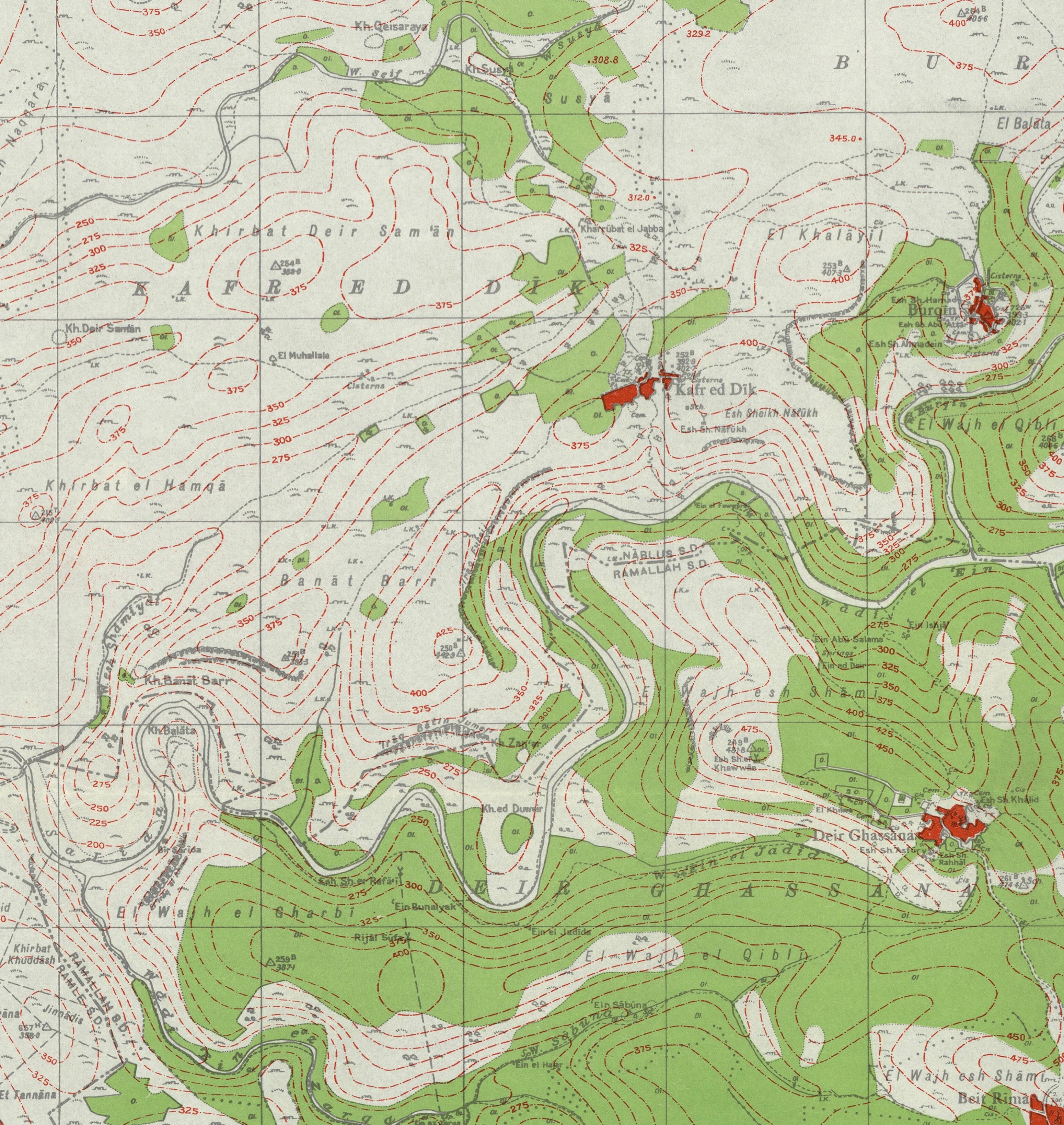
Kafr ad Dik located 9.59 km west of Salfit. It is bordered by Bruqin to the east, Bani Zaid to the south, Rafat and Deir Ballut to the west, and Biddya and Sarta to the north.
History
Archaeological surveys have not been conducted at the village.
It has been suggested that this is the place mentioned in Crusader sources under the name of Caphaer; a village connected with the Casale Santa Maria. In 1175, Crusader sources mentions a former cistern-keeper of the village.Röhricht, 1893, RHH, p. 142, no 533; quoted in Pringle, 1997, p. 13 In 1176, the revenues from Caphaer (=Kafr ad-Dik) and caslia S. Maria (=Aboud) were given for the provision of white bread for the sick in the Hospital in Jerusalem.
The coat of arms the Mamluk Sultan Qaitbay (1468–1496 C.E.) have been found in a mosque in the village.
Ottoman era
This village may be the Kafr Bani Hamid of the 1596 Ottoman tax records, with 83 Muslim families.
In the 18th and 19th centuries, the village formed part of the highland region known as Jūrat ‘Amra or Bilād Jammā‘īn. Situated between Dayr Ghassāna in the south and the present Route 5 in the north, and between Majdal Yābā in the west and Jammā‘īn, Mardā and Kifl Ḥāris in the east, this area served, according to historian Roy Marom, "as a buffer zone between the political-economic-social units of the Jerusalem and the Nablus regions. On the political level, it suffered from instability due to the migration of the Bedouin tribes and constant competition among local clans for the right to collect taxes on behalf of the Ottoman authorities."
In 1838 it was referred to as el-Kufr, part of the Jurat Merda district, south of Nablus.
In 1870 Victor Guérin found two birkets cut in the rock, one 15 paces long by 12 broad, the other not quite so large; about 30 cisterns and 20 tombs cut in the rock, some with sepulchral chambers, their walls pierced with loculi, others simple graves, either intended for a single body or having right and left vaulted tombs with arcosolia. These graves were formerly covered with stone slabs. There were also several lintels, decorated with the rectangular cartouche, on either side of which were triangles, and in the middle a cross. There are four mosques, built with stones and columns belonging to a Christian church. There is also a square tower, measuring 7 paces on each side. It is lit by loopholes, and is covered with immense slabs forming a roof, and supported by vaulted arcades. Within it is a cistern. On the lintel is a cross with equal branches inserted in a circle near four semicircles, which lie in a four-leaved rose. This tower formed part of a larger building, now destroyed.
Guérin writes that the houses were constructed from red and white stone masonry, as in Deir Ghassaneh and Beit Rima.
In 1870/1871 (1288 AH), an Ottoman census listed the village in the nahiya (sub-district) of Jamma'in al-Thani, subordinate to Nablus.
In 1882, the PEF's Survey of Western Palestine described a hillside village of moderate size with ancient rock-cut tombs to the east.
British Mandate era
In the 1922 census of Palestine conducted by the British Mandate authorities, Kufr al-Dik had a population of 487, all Muslim, increasing in the 1931 census to 665, still all Muslim, in 139 houses.
In the 1945 statistics the population was 870, all Muslims, while the total land area was 15,308 dunams, according to an official land and population survey. Of this, 2,075 were used for plantations and irrigable land, 2,603 for cereals, while 58 dunams were classified as built-up areas.
Jordanian era
In the wake of the 1948 Arab–Israeli War, and after the 1949 Armistice Agreements, Kafr ad-Dik came under Jordanian rule. It was annexed by Jordan in 1950.
In 1961, the population was 1,365.
1967–present
Main article: Israeli–Palestinian conflict


Since the Six-Day War in 1967, Kafr ad-Dik has been under Israeli occupation.
After the 1995 accords, 14.5% of village land was classified as Area B, the remaining 85.5% as Area C. Land was expropriated for the construction of Israeli settlements:
- 594 dunams for Pedu'el,
- 300 dunams for Alei Zahav,
- 144 dunams for Har Alei Zahav, and
- 246 dunams for an industrial zone, near Pedu'el.
After an Israeli court approved the expropriation of 3,000 dunams (750 acres) of private land in Kafr ad-Dik's Thahir Subih neighborhood, bulldozers reportedly uprooted dozens of olive trees and fruit trees while leveling over 10,000 dunams (2,500 acres). The Israel Civil Administration spokesperson said the works were part of a national agricultural development plan. In Israel's view, these are Israeli state lands.
Demography
Residents of Deir Istiya, Sanniriya, Kafr Jammal, Attil, Annaba, Ballut and Nablus, trace their ancestry back to this village.
References
Bibliography
References
- [http://vprofile.arij.org/salfit/pdfs/vprofile/Kafr%20ad%20Dik_tp_en.pdf Kafr ad Dik Town Profile], ARIJ, 2013, p. 4
- (February 2018). "Preliminary Results of the Population, Housing and Establishments Census, 2017". [[State of Palestine]].
- Palmer, 1881, p. [https://archive.org/stream/surveyofwesternp00conduoft#page/230/mode/1up 230]
- link. (2007-05-28 [[Applied Research Institute Jerusalem]] 2007-03-05.)
- [https://web.archive.org/web/20140111012805/http://poica.org/editor/case_studies/view.php?recordID=1057 House Demolitions warnings in Kafr ad Dik village] [[Applied Research Institute Jerusalem]] 2007-05-07.
- Finkelstein, Israel. (1997). "Highlands of Many Cultures". Institute of Archaeology of Tel Aviv University Publications Section.
- [[Charles Simon Clermont-Ganneau. Clermont-Ganneau]], 1898, pp. [https://archive.org/stream/RecueilDarcheologieOrientaletome2/Recueil_d_archologie_orientale-7#page/n179/mode/1up 166]-176; [[Joshua Prawer. Prawer]] and [[David Benvenisti. Benvenisti]], 1970; all cited in [[Israel Finkelstein. Finkelstein]], et al., 1997, pp. 267–8
- Röhricht, 1893, RHH, p. [https://archive.org/stream/regestaregnihie00rhgoog#page/n145/mode/1up 145], no 547; cited in Pringle, 1993, p. [https://books.google.com/books?id=BgQ6AAAAIAAJ&pg=PA18 18]
- DOA Mandatorial file; cited in Finkelstein, et al., 1997, p. 268
- Hütteroth and Abdulfattah, 1977, p. 132, according to Grossman, 1986, p. 354, cited in Finkelstein, 1998, p. 268
- Marom, Roy. (2022-11-01). "Jindās: A History of Lydda's Rural Hinterland in the 15th to the 20th Centuries CE". Lod, Lydda, Diospolis.
- Robinson and Smith, 1841, vol 3, 2nd appendix, p. [https://archive.org/stream/biblicalresearch03robiuoft#page/127/mode/1up 127]
- Guérin, 1875, pp. [https://archive.org/stream/descriptiongogr04gugoog#page/n178/mode/1up 153], [https://archive.org/stream/descriptiongogr04gugoog#page/n179/mode/1up 154], as cited in Conder and Kitchener, 1882, SWP II, p. [https://archive.org/stream/surveyofwesternp02conduoft#page/324/mode/1up 324]
- Guérin, 1875, pp. [https://archive.org/stream/descriptiongogr04gugoog#page/n178/mode/1up 153] ff
- Grossman, David. (2004). "Arab Demography and Early Jewish Settlement in Palestine". Magnes Press.
- Conder and Kitchener, 1882, SWP II, p. [https://archive.org/stream/surveyofwesternp02conduoft#page/284/mode/1up 284]
- Barron, 1923, Table IX, Sub-district of Nablus, p. [https://archive.org/stream/PalestineCensus1922/Palestine%20Census%20%281922%29#page/n28/mode/1up 26]
- Mills, 1932, p. [https://archive.org/details/CensusOfPalestine1931.PopulationOfVillagesTownsAndAdministrativeAreas 61].
- Department of Statistics, 1945, p. [http://users.cecs.anu.edu.au/~bdm/yabber/census/VSpages/VS1945_p18.jpg 18]
- Government of Palestine, Department of Statistics. ''Village Statistics, April, 1945.'' Quoted in Hadawi, 1970, p. [http://www.palestineremembered.com/download/VillageStatistics/Table%20I/Nablus/Page-060.jpg 60]
- Government of Palestine, Department of Statistics. ''Village Statistics, April, 1945.'' Quoted in Hadawi, 1970, p. [http://www.palestineremembered.com/download/VillageStatistics/Table%20II/Nablus/Page-106.jpg 106]
- Government of Palestine, Department of Statistics. ''Village Statistics, April, 1945.'' Quoted in Hadawi, 1970, p. [http://www.palestineremembered.com/download/VillageStatistics/Table%20III/Nablus/Page-156.jpg 156]
- Government of Jordan, Department of Statistics, 1964, p. [http://users.cecs.anu.edu.au/~bdm/yabber/census/JordanCensusPages/JordanCensus1961-p26.pdf 26] It was further noted (note 2) that it was governed through a village council.
- [http://vprofile.arij.org/salfit/pdfs/vprofile/Kafr%20ad%20Dik_tp_en.pdf Kafr ad Dik Town Profile], ARIJ, p. 17
- [https://archive.today/20140702010306/http://www.maannews.net/eng/ViewDetails.aspx?ID=708650 'Israeli bulldozers 'level Palestinian land, uproot trees' near Salfit,'] [[Ma'an News Agency]] 29 June 2014.
- Grossman, D. (1986). "Oscillations in the Rural Settlement of Samaria and Judaea in the Ottoman Period". in '''Shomron studies'''. Dar, S., Safrai, S., (eds). Tel Aviv: Hakibbutz Hameuchad Publishing House. p. 354
This article was imported from Wikipedia and is available under the Creative Commons Attribution-ShareAlike 4.0 License. Content has been adapted to SurfDoc format. Original contributors can be found on the article history page.
Ask Mako anything about Kafr ad-Dik — get instant answers, deeper analysis, and related topics.
Research with MakoFree with your Surf account
Create a free account to save articles, ask Mako questions, and organize your research.
Sign up freeThis content may have been generated or modified by AI. CloudSurf Software LLC is not responsible for the accuracy, completeness, or reliability of AI-generated content. Always verify important information from primary sources.
Report