From Surf Wiki (app.surf) — the open knowledge base
Johnston County, Oklahoma
County in Oklahoma, United States
County in Oklahoma, United States
| Field | Value |
|---|---|
| county | Johnston County |
| state | Oklahoma |
| ex image | Administration with North Lawn at Murray State College.jpg |
| ex image size | 200px |
| ex image cap | Murray State College in Tishomingo. |
| founded year | 1907 |
| seat wl | Tishomingo |
| largest city wl | Tishomingo |
| area_total_sq_mi | 658 |
| area_land_sq_mi | 643 |
| area_water_sq_mi | 15 |
| area percentage | 2.3% |
| population_as_of | 2020 |
| population_total | 10272 |
| density_sq_mi | auto |
| time zone | Central |
| web | www.johnstoncountyok.org |
| named for | Douglas H. Johnston |
| district | 2nd |
Johnston County is a county located in the U.S. state of Oklahoma. As of the 2020 census, the population was 10,272. Its county seat is Tishomingo. It was established at statehood on November 16, 1907, and named for Douglas H. Johnston, a governor of the Chickasaw Nation.
Johnston County is part of the Texoma Region.
History
In 1820, the U.S. government granted the land now known as Johnston County to the Choctaw tribe. Many of the Choctaws began moving to the new land in Indian Territory in 1830. The rest followed Chickasaw tribe, who were closely related to the Choctaw, formally separated from the Choctaw Nation in the late 1830s, relocating to the western part of the Choctaw Nation. The Chickasaw Nation named the town of Tishomingo as its capital and built a brick capitol building there in 1856.
Several educational institutions were established in the Chickasaw Nation before the Civil War. The Pleasant Grove Mission School and the Chickasaw Academy were founded by the Methodist Episcopal Church in 1844. The Presbyterians, in partnership with the Chickasaw Nation, opened the Wapanucka Female Manual Labour School in 1852.
The Chickasaw government joined the Confederate States of America after the outbreak of the Civil War. The Union army ordered its troops to evacuate Fort Washita, Fort Cobb and Fort Arbuckle. When Confederate troops occupied the area, they used the stone building at Wapanucka as a hospital and a prison.
Several railroads built tracks through this area about the turn of the 20th century. In 1900–1901 the St. Louis, Oklahoma and Southern Railway, which the St. Louis and San Francisco Railroad (Frisco) purchased in June 1901, laid tracks north–south through the area. In 1902, the Western Oklahoma Railroad, which became the Choctaw, Oklahoma and Gulf Railroad (CO&G), built a line southwest to northeast through the present county. In 1908 – 1910 the Missouri, Oklahoma and Gulf Railway (MO&G), (acquired by the Kansas, Oklahoma and Gulf Railway in 1919,) laid a north–south line in the far eastern portion of Johnston County. In 1911, the MO&G built a spur west to Bromide, an early-twentieth-century health resort, capitalizing on the vicinity's natural springs. Now the Burlington Northern and Santa Fe, which acquired the Frisco in 1980, is the only railroad left in the county.
Geography
According to the U.S. Census Bureau, the county has a total area of 658 sqmi, of which 643 sqmi is land and 15 sqmi (2.3%) is water.
The northern part of the county lies in the Arbuckle Mountains, which consists of rock outcroppings and rolling hills. The southern part of the county is part of the Coastal Plains region, and is more suitable for farming. The county is drained by the Washita and Blue Rivers and Pennington Creek, which are all tributaries of the Red River. An arm of Lake Texoma protrudes into southern Johnston County.
Major highways
- [[Image:US 377.svg|23px]] U.S. Highway 377
- [[Image:Oklahoma State Highway 1.svg|20px]] State Highway 1
- [[Image:Oklahoma State Highway 7.svg|20px]] State Highway 7
- State Highway 12
- [[Image:Oklahoma State Highway 22.svg|20px]] State Highway 22
- [[Image:Oklahoma State Highway 48.svg|20px]] State Highway 48
- [[Image:Oklahoma State Highway 78.svg|20px]] State Highway 78
Adjacent counties
- Pontotoc County (north)
- Coal County (northeast)
- Atoka County (east)
- Bryan County (southeast)
- Marshall County (south)
- Carter County (west)
- Murray County (northwest)
National protected area
- Tishomingo National Wildlife Refuge (part)
Demographics
|align-fn=center 1790-1960 1900-1990 1990-2000 2010
| Race (NH = Non-Hispanic) | 2010 | 2000 | 1990 | 1980 |
|---|---|---|---|---|
| White alone (NH) | 65.6% | |||
| (6,735) | 71.7% | |||
| (7,854) | 75.4% | |||
| (7,927) | 81% | |||
| (8,126) | ||||
| Black alone (NH) | 2.3% | |||
| (236) | 1.9% | |||
| (209) | 1.7% | |||
| (174) | 2.1% | |||
| (213) | ||||
| American Indian alone (NH) | 15.4% | |||
| (1,582) | 14.9% | |||
| (1,636) | 14.9% | |||
| (1,562) | 15.5% | |||
| (1,558) | ||||
| Asian alone (NH) | 0.5% | |||
| (52) | 0.2% | |||
| (27) | 0.3% | |||
| (28) | 0.1% | |||
| (14) | ||||
| Pacific Islander alone (NH) | 0% | |||
| (5) | 0% | |||
| (1) | 0% | |||
| (5) | ||||
| Other race alone (NH) | 0.6% | |||
| (57) | 0% | |||
| (5) | 0% | |||
| (4) | 0% | |||
| (1) | ||||
| Multiracial (NH) | 10% | |||
| (1,024) | 7.3% | |||
| (802) | 5.3% | |||
| (553) | — | |||
| Hispanic/Latino (any race) | 5.7% | |||
| (581) | 3.9% | |||
| (423) | 2.5% | |||
| (260) | 1.2% | |||
| (120) |
2020 census
As of the 2020 United States census, the county had a population of 10,272. Of the residents, 22.6% were under the age of 18 and 19.7% were 65 years of age or older; the median age was 40.4 years. For every 100 females there were 100.9 males, and for every 100 females age 18 and over there were 99.5 males.
The racial makeup of the county was 67.1% White, 2.4% Black or African American, 16.2% American Indian and Alaska Native, 0.5% Asian, 2.4% from some other race, and 11.4% from two or more races. Hispanic or Latino residents of any race comprised 5.7% of the population. Counting only non-Hispanic residents, 65.6% were White, 15.4% were American Indian, 2.3% were Black, 0.5% were Asian, 0.6% were of some other race, and 10.0% were multiracial.
Self-reported ancestries in 2020 were led by English (16.5%), Chickasaw (11.6%), Irish (10.7%), German (7.1%), Choctaw (4.8%), Mexican (4.2%), Cherokee (2.4%), Choctaw Nation of Oklahoma (2.1%), African American (1.6%), and Scottish (1.5%).
There were 3,961 households in the county, of which 31.5% had children under the age of 18 living with them and 25.8% had a female householder with no spouse or partner present. About 28.3% of all households were made up of individuals and 13.0% had someone living alone who was 65 years of age or older.
There were 4,682 housing units, of which 15.4% were vacant. Among occupied housing units, 71.4% were owner-occupied and 28.6% were renter-occupied. The homeowner vacancy rate was 2.0% and the rental vacancy rate was 11.8%.
2000 census
As of the census of 2000, there were 10,513 people, 4,057 households, and 2,900 families residing in the county. The population density was 16 /mi2. There were 4,782 housing units at an average density of 7 /mi2. The racial makeup of the county was 76.09% White, 1.66% Black or African American, 15.32% Native American, 0.27% Asian, 0.05% Pacific Islander, 1.24% from other races, and 5.38% from two or more races. 2.47% of the population were Hispanic or Latino of any race. 97.0% spoke English, 1.6% Spanish and 1.2% Choctaw as their first language.
There were 4,057 households, out of which 31.30% had children under the age of 18 living with them, 56.60% were married couples living together, 10.70% had a female householder with no husband present, and 28.50% were non-families. 25.20% of all households were made up of individuals, and 12.20% had someone living alone who was 65 years of age or older. The average household size was 2.53 and the average family size was 3.02.
In the county, the population was spread out, with 25.50% under the age of 18, 9.70% from 18 to 24, 25.00% from 25 to 44, 24.30% from 45 to 64, and 15.40% who were 65 years of age or older. The median age was 38 years. For every 100 females there were 96.80 males. For every 100 females age 18 and over, there were 94.10 males.
The median income for a household in the county was $24,592, and the median income for a family was $30,292. Males had a median income of $25,240 versus $19,868 for females. The per capita income for the county was $13,747. About 17.80% of families and 22.00% of the population were below the poverty line, including 28.00% of those under age 18 and 19.30% of those age 65 or over.
Politics
| Voter Registration and Party Enrollment as of June 30, 2023 | Party | Number of Voters | Percentage | Total | 5,868 | 100% |
|---|---|---|---|---|---|---|
| Democratic | 1,970 | 33.57% | ||||
| Republican | 3,130 | 53.34% | ||||
| Libertarian | 38 | 0.65% | ||||
| Independent | 730 | 12.44% |
Education
Murray State School of Agriculture opened in Tishomingo in 1908. In 1972 the community college's name changed to Murray State College.
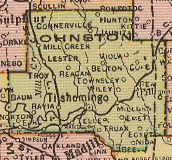
Communities
Cities
- Tishomingo (county seat)
Towns
- Bromide
- Mannsville
- Milburn
- Mill Creek
- Ravia
- Wapanucka
Census-designated places
- Bee
- Coleman
- Connerville
- Earl
- Emet
- Pontotoc
- Reagan
Other unincorporated communities
- Fillmore
- Folsom
- Nida
- Russett
- Troy
Notable people
- Bill Anoatubby, governor of the Chickasaw Nation.
- Neill Armstrong, coach of the Chicago Bears.
- Gene Autry, American performer raised in Ravia.
- Te Ata Fisher, Chickasaw storyteller, born in Emet.
- William H. "Alfalfa Bill" Murray, former governor of Oklahoma.
- Johnston Murray, son of William H. Murray and also a governor of Oklahoma.
- Harriet Wright O'Leary (1916-1999), American teacher and politician and first woman to serve on the tribal council of the Choctaw Nation of Oklahoma
References
References
- "Johnston County, Oklahoma". [[United States Census Bureau]].
- "Find a County". National Association of Counties.
- O'Dell, Larry. [http://www.okhistory.org/publications/enc/entry.php?entry=JO013 "Johnston County,"] ''Encyclopedia of Oklahoma History and Culture'', Oklahoma Historical Society, 2009. Accessed April 4, 2015.
- (August 22, 2012). "2010 Census Gazetteer Files". United States Census Bureau.
- "U.S. Decennial Census". United States Census Bureau.
- "Historical Census Browser". University of Virginia Library.
- (March 27, 1995). "Population of Counties by Decennial Census: 1900 to 1990". United States Census Bureau.
- (April 2, 2001). "Census 2000 PHC-T-4. Ranking Tables for Counties: 1990 and 2000". United States Census Bureau.
- "State & County QuickFacts". United States Census Bureau.
- "HISPANIC OR LATINO, AND NOT HISPANIC OR LATINO BY RACE (2020)". U.S. Census Bureau.
- "HISPANIC OR LATINO, AND NOT HISPANIC OR LATINO BY RACE (2010)". U.S. Census Bureau.
- "Oklahoma: 2000". U.S. Census Bureau.
- "Oklahoma: 1990".
- "General Social and Economic Characteristics: Oklahoma".
- (2021). "2020 Decennial Census Demographic Profile (DP1)".
- (2021). "2020 Decennial Census Redistricting Data (Public Law 94-171)".
- "Detailed Races and Ethnicities in the United States and Puerto Rico: 2020 Census". U.S. Census Bureau.
- "U.S. Census website". [[United States Census Bureau]].
- (January 15, 2019). "Oklahoma Registration Statistics by County".
- Leip, David. "Dave Leip's Atlas of U.S. Presidential Elections".
- . (July 30, 1979). ["Representative Roberts Choctaw Chief"](https://www.newspapers.com/article/sapulpa-daily-herald-representative-robe/130919239/). *[[Sapulpa Daily Herald]]*.
- . (August 22, 1983). ["Choctaw Nation Ballots; Runoff Scheduled September 17"](https://www.newspapers.com/article/tulsa-world-choctaw-nation-ballots-runo/130926354/). *[[Tulsa World]]*.
This article was imported from Wikipedia and is available under the Creative Commons Attribution-ShareAlike 4.0 License. Content has been adapted to SurfDoc format. Original contributors can be found on the article history page.
Ask Mako anything about Johnston County, Oklahoma — get instant answers, deeper analysis, and related topics.
Research with MakoFree with your Surf account
Create a free account to save articles, ask Mako questions, and organize your research.
Sign up freeThis content may have been generated or modified by AI. CloudSurf Software LLC is not responsible for the accuracy, completeness, or reliability of AI-generated content. Always verify important information from primary sources.
Report