From Surf Wiki (app.surf) — the open knowledge base
Johnson County, Iowa
County in Iowa, United States

County in Iowa, United States
| Field | Value | |||
|---|---|---|---|---|
| county | Johnson County | |||
| state | Iowa | |||
| ex image | Johnson county courhouse iowa.jpg | |||
| ex image size | 240px | |||
| ex image cap | Johnson County Courthouse | |||
| seal | Johnson County IA logo.jpg | |||
| founded date | December 21 | |||
| founded year | 1837 | |||
| seat wl | Iowa City | |||
| largest city wl | Iowa City | |||
| area_total_sq_mi | 623 | |||
| area_land_sq_mi | 614 | |||
| area_water_sq_mi | 9.1 | |||
| area percentage | 1.5 | |||
| census yr | 2020 | |||
| pop | 152854 | |||
| pop_est_as_of | 2024 | |||
| population_est | 160080 | |||
| pop_est_footnotes | {{cite web | url= https://www.census.gov/data/tables/time-series/demo/popest/2020s-counties-total.html | title=County Population Totals and Components of Change: 2020-2024 | website=census.gov |
| publisher | US Census Bureau | access-date= March 13, 2025}} | ||
| density_sq_mi | 260 | |||
| time zone | Central | |||
| web | https://www.johnsoncountyiowa.gov/ | |||
| district | 1st | |||
| named for | Richard Mentor Johnson (1837–2020) | |||
| Lulu Johnson (since 2020) |
Lulu Johnson (since 2020) }}
Johnson County is located in the U.S. state of Iowa. As of the 2020 census, the population was 152,854, making it the fourth-most populous county in Iowa. The county seat is Iowa City, home of the University of Iowa. Johnson County is included in the Iowa City metropolitan area, which is also included in the Cedar Rapids-Iowa City Corridor Combined Statistical Area.
History
Johnson County was established in December 1837 by the legislature of the Wisconsin Territory, one of thirteen counties established by that body in a comprehensive act. The county's area was partitioned from Dubuque County, and was not initially provided with a civil government, instead being governed by Cedar County officials. It was originally named for the US Vice President Richard M. Johnson (1780–1850). In 2020, the Johnson County Board of Supervisors voted unanimously to change the county's namesake to be Lulu Merle Johnson (1907–1995), the first black woman in the state to earn a doctorate. Vice President Johnson had a common law wife whom he could not marry since it was against the laws at that time to have an interracial marriage. They had two children together and she was in charge of his plantation when he was away on business. He was open about his relationship with her which was unusual for the time. Many feel that either namesake is worthy.
The first courthouse in the county was a two-story log cabin structure, built in 1838 in the settlement of Napoleon, about two miles south of the current courthouse. The building stood across from what later would become the James McCollister Farmstead on land later owned by Philip Clark.
After Iowa City was established by fiat as the new territorial capitol of Iowa, the county seat was removed there. The second Johnson County Courthouse, the first in Iowa City, was built on Lot 8 Block 8 of the County Seat Addition to Iowa City in 1842 for $3,690. It was built by James Trimble, who had previously built the first jail.
A third courthouse was built in 1857 in the courthouse square on Clinton Street between Court and Harrison Streets. It was used until 1901, after cracks appeared in its south wall in 1899. The building was apparently built of brick with stone and wood ornamentation.
The Richardsonian Romanesque style courthouse in use today was designed by the firm of Rush, Bowman and Rush of Grand Rapids, Michigan. It was bid at a cost of $111,000 and built by the firm Rowson & Son of Johnson County. The cornerstone was laid in December 1899. The building's tower was based on Henry Hobson Richardson's design for the spire of Trinity Church in Boston. The building was dedicated on June 8, 1901. The currently unused jail that stands to the west of the courthouse was designed by C.L. Wundt of Burlington, Iowa on behalf of the Stewart Iron Works in Cleveland and bid for $14,000.
Geography
According to the U.S. Census Bureau, the county has a total area of 623 sqmi, of which 614 sqmi is land and 9.1 sqmi (1.5%) is water.
Major highways
- [[File:I-80.svg|x20px]] Interstate 80
- [[File:I-380.svg|x20px]] Interstate 380
- [[File:US 6.svg|x20px]] U.S. Highway 6
- [[File:US 218.svg|x20px]] U.S. Highway 218
- [[File:Circle sign 1.svg|x20px]] Iowa Highway 1
- [[File:Elongated circle 22.svg|x20px]] Iowa Highway 22
- [[File:Elongated circle 27.svg|x20px]] Iowa Highway 27
Transit
- 380 Express
- Cambus
- Coralville Transit
- Iowa City Transit
Adjacent counties
- Benton County – northwest
- Cedar County – east
- Iowa County – west
- Linn County – north
- Muscatine County – east and southeast
- Louisa County – southeast and south
- Washington County – south
Demographics
|align-fn=center 1790–1960 1900–1990 1990–2000 2010–20202024
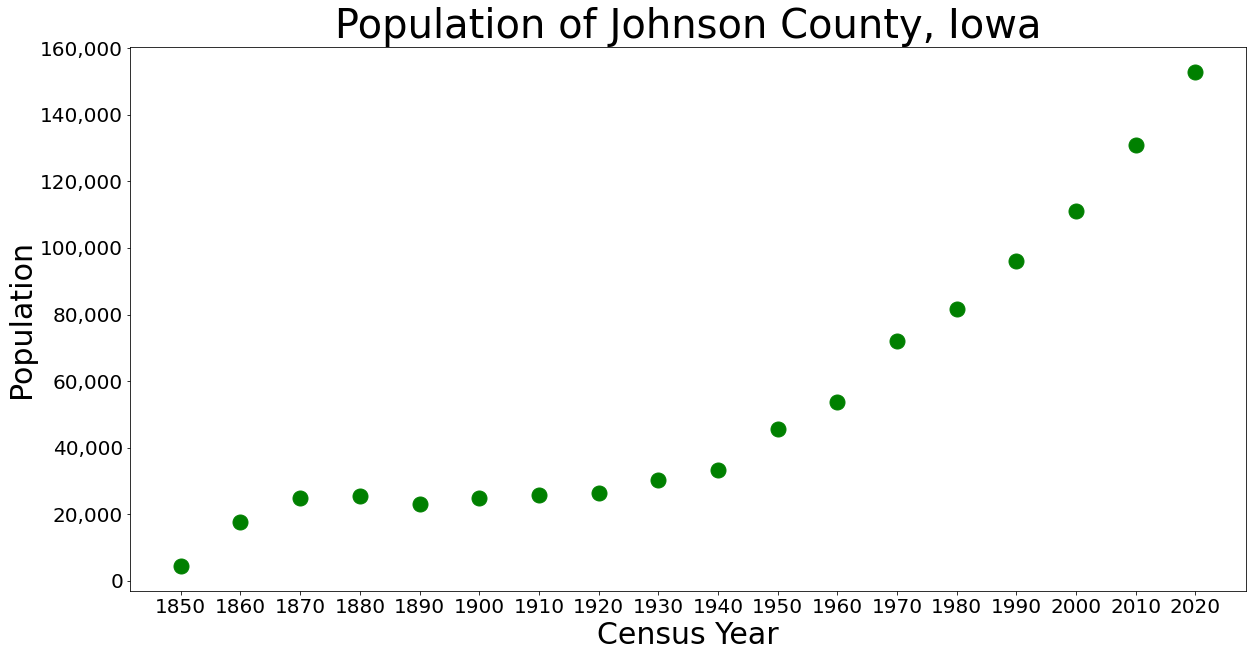
2020 census
As of the 2020 census, the county had a population of 152,854 and a population density of ; 93.62% of the population reported being of one race. The median age was 31.2 years, with 20.1% of residents under the age of 18 and 12.6% of residents 65 years of age or older. For every 100 females there were 98.1 males, and for every 100 females age 18 and over there were 96.1 males age 18 and over.
The racial makeup of the county was 76.6% White, 8.4% Black or African American, 0.2% American Indian and Alaska Native, 5.6% Asian,
83.3% of residents lived in urban areas, while 16.7% lived in rural areas.
There were 61,335 households in the county, of which 26.1% had children under the age of 18 living in them. Of all households, 42.0% were married-couple households, 22.6% were households with a male householder and no spouse or partner present, and 27.8% were households with a female householder and no spouse or partner present. About 31.5% of all households were made up of individuals and 8.5% had someone living alone who was 65 years of age or older.
There were 65,916 housing units, of which 6.9% were vacant. Among occupied housing units, 57.0% were owner-occupied and 43.0% were renter-occupied. The homeowner vacancy rate was 2.1% and the rental vacancy rate was 7.7%.
| Race | Num. | Perc. |
|---|---|---|
| White (NH) | 114,491 | 74.9% |
| Black or African American (NH) | 12,643 | 8.3% |
| Native American (NH) | 193 | 0.12% |
| Asian (NH) | 8,555 | 5.6% |
| Pacific Islander (NH) | 41 | 0.03% |
| Other/Mixed (NH) | 6,733 | 4.4% |
| Hispanic or Latino | 10,198 | 6.7% |
2010 census
The 2010 census recorded a population of 130,882 in the county, with a population density of . There were 55,967 housing units, of which 52,715 were occupied.
2000 census
As of the census of 2000, there were 111,006 people, 44,080 households, and 23,582 families residing in the county. The population density was 181 PD/sqmi. There were 45,831 housing units at an average density of 75 /mi2. The racial makeup of the county was 90.13% White, 2.90% Black or African American, 0.28% Native American, 4.12% Asian, 0.04% Pacific Islander, 1.01% from other races, and 1.51% from two or more races. 2.51% of the population were Hispanic or Latino of any race.
There were 44,080 households, out of which 26.50% had children under the age of 18 living with them, 43.90% were married couples living together, 6.80% had a female householder with no husband present, and 46.50% were non-families. 30.20% of all households were made up of individuals, and 5.60% had someone living alone who was 65 years of age or older. The average household size was 2.34 and the average family size was 2.97.
Age spread: 20.10% under the age of 18, 23.40% from 18 to 24, 30.80% from 25 to 44, 18.20% from 45 to 64, and 7.40% who were 65 years of age or older. The median age was 28 years. For every 100 females, there were 99.10 males. For every 100 females age 18 and over, there were 97.30 males.
The median income for a household in the county was $40,060, and the median income for a family was $60,112. Males had a median income of $36,279 versus $29,793 for females. The per capita income for the county was $22,220. About 5.20% of families and 15.00% of the population were below the poverty line, including 8.10% of those under age 18 and 3.80% of those age 65 or over.
Politics
Largely due to the presence of the University of Iowa, Johnson County is considered the most liberal county in Iowa and a stronghold of the Democratic Party, and has always been among Iowa's most Democratic counties since the Civil War. It has been the strongest Democratic county in the state since 1984. This trend predates the recent swing toward the Democrats in counties influenced by college towns (this trend was less prevalent in Story County, home Iowa State University in Ames, until 1988). The last Republican to win the county in a presidential election was Richard Nixon in 1960, and the last Republican to even get 40 percent of the county's vote was Ronald Reagan in 1984. The last time the GOP won the county in a gubernatorial election was the 1978 Iowa gubernatorial election. As a measure of how strongly Democratic the county has been, Democrats easily carried it even in the national Republican landslides of 1972, 1984 and 1988, and the county was the only county in Iowa to vote for Democrat Alton B. Parker over Republican Theodore Roosevelt in 1904. In 2020, Joe Biden received the highest percentage of the vote received by any Democrat in the county's history; indeed, by any candidate of any party. In 2024, it was the only county to not vote for Donald Trump in the state's Republican presidential caucuses. Nikki Haley won the county by a single vote.
Johnson County's Democratic bent is just as pronounced at the state level. It was the lone county to vote Democratic in statewide Republican landslides, such as Senator Chuck Grassley's re-elections in 2010 and 2016 or Governor Terry Branstad's re-election in 2014.
Communities
Cities
- Coralville
- Hills
- Iowa City
- Lone Tree
- North Liberty
- Oxford
- Shueyville
- Solon
- Swisher
- Tiffin
- University Heights
- West Branch (partially)
Census-designated place
- Frytown
Other unincorporated communities
- Amish
- Cosgrove
- Morse
- Newport
- Oakdale
- Oasis
- River Junction
- Sharon Center
- Sutliff
- Twin View Heights
- Western (partially)
- Windham
Ghost towns
- Elmira
- Midway
Townships
- Big Grove
- Cedar
- Clear Creek
- East Lucas
- Fremont
- Graham
- Hardin
- Jefferson
- Liberty
- Lincoln
- Madison
- Monroe
- Newport
- Oxford
- Penn
- Pleasant Valley
- Scott
- Sharon
- Union
- Washington
- West Lucas
Population ranking
The population ranking of the following table is based on the 2020 census of Johnson County.
† county seat
| Rank | City/Town/etc. | Municipal type | Population (2020 Census) |
|---|---|---|---|
| 1 | † Iowa City | City | 74,828 |
| 2 | Coralville | City | 22,318 |
| 3 | North Liberty | City | 20,479 |
| 4 | Tiffin | City | 4,512 |
| 5 | Solon | City | 3,018 |
| 6 | West Branch (mostly in Cedar County) | City | 2,509 |
| 7 | Lone Tree | City | 1,357 |
| 8 | University Heights | City | 1,228 |
| 9 | Swisher | City | 914 |
| 10 | Hills | City | 863 |
| 11 | Shueyville | City | 731 |
| 12 | Oxford | City | 722 |
| 13 | Frytown | CDP | 193 |
References
- Charles Ray Aurner, Leading Events in Johnson County, Iowa, History, Volume I (1912) reproduction by Torch Press, Cedar Rapids IA
References
- "2020 Census State Redistricting Data". United states Census Bureau.
- "Find a County". National Association of Counties.
- [[United States Office of Management and Budget]]. "Update of Statistical Area Definitions and Guidance on Their Uses".
- The other counties created on December 21, 1837: Benton, Buchanan, Cedar, Clayton, Clinton, Delaware, Fayette, Jackson, Jones, Keokuk, Linn, and Scott.
- ''History of Johnson County, Iowa 1836-1882'' (1883). Reproduction by Unigraphic Inc. pp. 165-6.
- Sherman, Cymphanie. (September 24, 2020). "Johnson County votes unanimously to change namesake".
- This no longer exists as a separate settlement but as part of Iowa City. Its former existence is recognized by the present Napoleon Park, accessed via Napoleon Lane (41.63350N, 91.53147W). [https://www.google.com/maps/place/Napoleon+Ln,+Iowa+City,+IA+52240/@41.6321278,-91.5327896,16.5z/data=!4m5!3m4!1s0x87e44032f68627d1:0xe5594c9bd80af08c!8m2!3d41.6309205!4d-91.5306138 ''Napoleon Lane'' Google Maps (accessed 18 August 2018)]
- Aurner, p. 492.
- Aurner, pp. 47, 72.
- This location was in the southeast corner of the intersection of Harrison and Clinton Streets. The building was 56 x 28 feet and two stories tall.Aurner, pp. 21, 492.
- Aurner, p. 494.
- Aurner, p. 65.
- Daily Iowa State Press, April 1, 1899, p. 5
- Aurner, pp. 496-7.
- Aurner, p. 496.
- "The Johnson County Courthouse".
- Aurner, p. 496
- Aurner, p. 497.
- (February 12, 2011). "US Gazetteer files: 2010, 2000, and 1990". [[United States Census Bureau]].
- "U.S. Decennial Census". US Census Bureau.
- "Historical Census Browser". University of Virginia Library.
- "Population of Counties by Decennial Census: 1900 to 1990". US Census Bureau.
- "Census 2000 PHC-T-4. Ranking Tables for Counties: 1990 and 2000". US Census Bureau.
- "State & County QuickFacts". United States Census Bureau.
- "County Population Totals and Components of Change: 2020-2024". United States Census Bureau.
- (2021). "2020 Decennial Census Demographic Profile (DP1)".
- (2021). "2020 Decennial Census Redistricting Data (Public Law 94-171)".
- (2023). "2020 Decennial Census Demographic and Housing Characteristics (DHC)".
- "P2 HISPANIC OR LATINO, AND NOT HISPANIC OR LATINO BY RACE – 2020: DEC Redistricting Data (PL 94-171) – Johnson County, Iowa".
- "Population & Housing Occupancy Status 2010". US Census Bureau – American FactFinder.
- "U.S. Census website". US Census Bureau.
- "Presidential election of 1848 - Map by counties".
- (January 15, 2024). "Iowa Caucus Results". The New York Times.
- "Iowa Caucus 2024 Live Election Results". NBC News.
- Hansen, Ryan. (2024-01-16). "Iowa Caucus: Nikki Haley narrowly defeats Trump in Johnson County".
- Leip, David. "Dave Leip's Atlas of U.S. Presidential Elections".
This article was imported from Wikipedia and is available under the Creative Commons Attribution-ShareAlike 4.0 License. Content has been adapted to SurfDoc format. Original contributors can be found on the article history page.
Ask Mako anything about Johnson County, Iowa — get instant answers, deeper analysis, and related topics.
Research with MakoFree with your Surf account
Create a free account to save articles, ask Mako questions, and organize your research.
Sign up freeThis content may have been generated or modified by AI. CloudSurf Software LLC is not responsible for the accuracy, completeness, or reliability of AI-generated content. Always verify important information from primary sources.
Report