From Surf Wiki (app.surf) — the open knowledge base
Jish

| Field | Value | |
|---|---|---|
| name | Jish | |
| native_name | {{Hlist | |
| rtl | yes}} | |
| rtl | yes}} | |
| settlement_type | Local council | |
| translit_lang1 | Hebrew | |
| translit_lang1_type1 | ISO 259 | |
| translit_lang1_info1 | Ǧiš, Guš Ḥalav | |
| image_skyline | ג'ש2.JPG | |
| imagesize | 250px | |
| pushpin_map | Israel northeast#Israel | |
| pushpin_mapsize | 250 | |
| coordinates | ||
| grid_name | Grid position | |
| grid_position | 191/270 PAL | |
| subdivision_type | Country | |
| subdivision_name | ||
| subdivision_type2 | District | |
| subdivision_name2 | Northern | |
| established_title | Founded | |
| established_date | 2000 BC (Earliest settlement) | |
| 1300 BC (Gush Halav) | ||
| leader_title | Head of Municipality | |
| leader_name | Elias Elias | |
| unit_pref | dunam | |
| area_total_dunam | ||
| population_footnotes | ||
| population_total | ||
| population_as_of | ||
| population_density_km2 | auto | |
| demographics_type1 | Ethnicity | |
| demographics1_footnotes | ||
| demographics1_title1 | Arabs | |
| demographics1_info1 | 98.4% | |
| demographics1_title2 | Jews and others | |
| demographics1_info2 | 1.6% | |
| website | ||
| blank_name_sec1 | Name meaning | |
| blank_info_sec1 | A lump of milk |
| {{Script/Hebrew|גִ'שׁ, גּוּשׁ חָלָב}} | {{lang|ar|الجش}} 1300 BC (Gush Halav) Jish (, ar), also known by its Hebrew name of Gush Halab (, he), or by its classical name of Gischala, is a local council in Upper Galilee, located on the northeastern slopes of Mount Meron, 13 km north of Safed, in Israel's Northern District. In , it had a population of , which is predominantly Maronite Catholic and Melkite Greek Catholic Christians (63%), with a Sunni Muslim Arab minority (about 35.7%).
Jish is the ancient Giscala or Gush Halav, first mentioned in the historical record by the Roman-Jewish historian Josephus, who described it as the home of John of Giscala and the last city in the Galilee to fall to the Romans during the First Jewish–Roman War (War 4:93). Archeological excavations uncovered remains from the Canaanite and Israelite periods; later archaeological finds in Jish include two ancient synagogues, a unique mausoleum and rock-cut tombs from the Roman and Byzantine periods. Historical sources dating from the 10th-15th centuries describe Jish (Gush Halav) as a village with a strong Jewish presence.
In the early Ottoman era, Jish was wholly Muslim. In the 17th century, the village was inhabited by Druze. In 1945, under British rule, Jish had a population of 1,090 with an area of 12,602 dunams. The village was largely depopulated during the 1948 Palestine war as part of the larger 1948 Palestinian expulsion and flight. After the war Jish was resettled not only by the original inhabitants, who were largely Maronite Christians, but also by some Maronite Christians who were expelled from the razed villages of Kafr Bir'im and some Muslims who were expelled from Dallata.
In 2010, the population of Jish was 3,000. The village is a center for the Aramaic revival, an initiative by some local Maronites, now officially funded by the Israeli Ministry of Education until 8th grade in the local governmental school.
Etymology
Jish is the ancient Giscala. The Arabic name el-Jish is a variation of the site's ancient name Gush Halav in Hebrew, literally "block of milk" or "a lump of milk," which may be a reference to either the production of milk and cheese (for which the village has been famous since at least the early Middle Ages) or else to the fertile surroundings, which are well-suited for various forms of agriculture. Other scholars believe the name Gush Halav refers to the light color of the local limestone, which contrasts with the dark reddish rock of the neighboring village, Ras al-Ahmar.
History
Ancient period
Settlement in Jish dates back 3,000 years. The village is mentioned in the Mishnah as Gush Halav, a city "surrounded by walls since the time of Joshua Ben Nun" (m. Arakhin 9:6). Canaanite and Israelite remains from the Early Bronze and Iron Ages have also been found there.
Classical antiquity
During the Classical period, the town was known as Gischala, a Greek transcription of the Hebrew name Gush Halav. Both Josephus and later Jewish sources from the Roman-Byzantine period mention the fine olive oil for which the village was known. According to the Talmud, the inhabitants also engaged in the production of silk. Jerome recorded that Paul the Apostle lived with his parents in "Giscalis in Judea," which is understood to be Gischala.
After the fall of Gamla, Gush Halav was the last Jewish stronghold in the Galilee and Golan region during the Great Jewish Revolt against Rome (66-73 CE), and the home of John of Giscala.
Two ancient synagogues were discovered at Jish. The first was located at the top of the hill, below the current Maronite Church. The second one was discovered at the foot of the hill, close to a spring; one of its columns is inscribed in Aramaic with the name of a particular "Yose son of Tanhum". This synagogue went through several phases of construction and reconstruction, one destruction being dated by excavator Eric M. Meyers to the earthquake of 551. In addition to Jewish structures and burial sites dated to the 3rd through 6th centuries, Christian artifacts from the Byzantine period have been found at the site.
According to local tradition, two nearby rock-cut tombs contain the graves of 1st century BCE Jewish sages Shemaiah and Avtalyon.
Middle Ages
Historical sources from the 10th to the 15th centuries describe it as a large Jewish village, and it is mentioned in the 10th century by Arab geographer Al-Muqaddasi. Jewish life in the 10th and 11th centuries is attested to by documents in the Cairo Geniza. In 1172, the Jewish traveler Benjamin of Tudela found about 20 Jews living there. In 1322, during his journey through the Land of Israel, Ishtori Haparchi noted that the Jewish community of Gush Halav read the Megillat Esther in Purim on both the 14th and the 15th of Adar.
Ottoman Empire
In 1596, Jish appeared in Ottoman tax registers as being in the Nahiya of Jira, of the Liwa Safad. It had a population of 71 households and 20 bachelors, all Muslim. The villagers paid taxes on goats and beehives, but most of its taxes were in the form of a fixed sum: total taxes amounted to around 30,750 akçe.
In the 17th century, the village had been inhabited by Druze, but they later departed from it.
According to Yitzhak Ben-Zvi, Maronites first settled in Jish during the early 18th century. This may have happened as a result of the Battle of Ain Dara (1711), in which the Qaysis defeated the Yamanis and drove many of them from Mount Lebanon. Ben-Zvi recorded a local tradition, according to which two families in the village preceded the Maronite immigration; One of them—the Hashouls, the oldest family in the village— were Maronites of Jewish ancestry and were originally known by the name Shaul.
The Galilee earthquake of 1837 caused widespread damage and over 200 deaths. Three weeks afterward, contemporaries reported "a large rent in the ground...about a foot wide and fifty feet long." All the Galilee villages that were badly damaged at the time, including Jish, were situated on the slopes of steep hills. The presence of old landslides has been observed on aerial photographs. The fact that the village was built on dip slopes consisting of soft bedrock and soil has made it more vulnerable to landslides. According to Andrew Thomson, no houses in Jish were left standing. The church fell, killing 130 people, and the old town walls collapsed. A total of 235 people died, and the ground was left fissured. At the time, the village was noted as a mixed Muslim and Maronite village in the Safad district.
At the end of the 19th century, Jish was described as a "well-built village of good masonry" with about 600 Christian and 200 Muslim inhabitants.
A population list from about 1887 showed El Jish to have about 1,935 inhabitants; 975 Christians and 960 Muslims.
British Mandate


At the time of the 1922 census of Palestine, Jish had a population of 721–380 Christians and 341 Muslims. The Christians were classified as 71% Maronite and 29% Greek Catholic (or Melchite). By the 1931 census, Jish had 182 inhabited houses and a population of 358 Christians and 397 Muslims.
In the 1945 statistics, Jish had a population of 1,090; 350 Christians and 740 Muslims, and the village spanned 12,602 dunams, mostly Arab-owned. Of this, 1,506 dunums were plantations and irrigable land, 6,656 used for cereals, while 72 dunams were built-up (urban) land.
1948 Palestine war
Israeli forces captured Jish on 29 October 1948, during Operation Hiram. A massacre was perpetrated by Israeli troops. Historian Saleh Abdel Jawad has estimated "at least 100 fatalities". Historian Benny Morris wrote that "the troops apparently murdered about 10 Moroccan POWs (who had served with the Syrian Army) and a number of civilians, including, apparently, four Maronite Christians, and a woman and her baby."
The Israeli prime minister, David Ben-Gurion, ordered an investigation of the deaths but no IDF soldiers were brought to trial, though a military investigation concluded with the order that those responsible for the unjustified killings were to be tried 'immediately'.
Many of the residents of Jish were forced to leave the village in 1948 and became Palestinian refugees in Lebanon. Some Christians from the nearby town of Kafr Bir'im resettled in Jish,
Elias Chacour, now Archbishop of the Melkite Greek Catholic Church, whose family resettled in Jish, wrote that when he was eight years old he discovered a mass grave containing two dozen bodies.
Israel

In December 2010, a hiking and bicycle path known as the Coexistence Trail was inaugurated, linking Jish with Dalton, a neighboring Jewish village. The 2,500 meter-long trail, accessible to people with disabilities, sits 850 meters above sea level and has several lookout points, including a view of Dalton Lake, where rainwater is collected and stored for agricultural use.
Jish is known for its efforts to revive Aramaic as a living language. In 2011, the Israeli Ministry of Education approved a program to teach the language in Jish elementary schools. Some local Maronite activists in Jish say that Aramaic is essential to their existence as a people, in the same way that Hebrew and Arabic are for Jews and Arabs.
Demographics
Today, 55% of the inhabitants of Jish are Maronite Christians, 10% percent are Melkites and 35% percent are Muslims. The population of the village was .
In 2022, 63% of the population was Christian and 37% was Muslim.{{Cite web |title=ג'ש )גוש חלב)
Geography
Jish is located in Upper Galilee, in the Northern district of Israel. The town is close to Mount Meron, the tallest standing mountain of Galilee. Recently, a new road has connected Jish with the nearby Jewish village of Dalton.
Religious sites and shrines
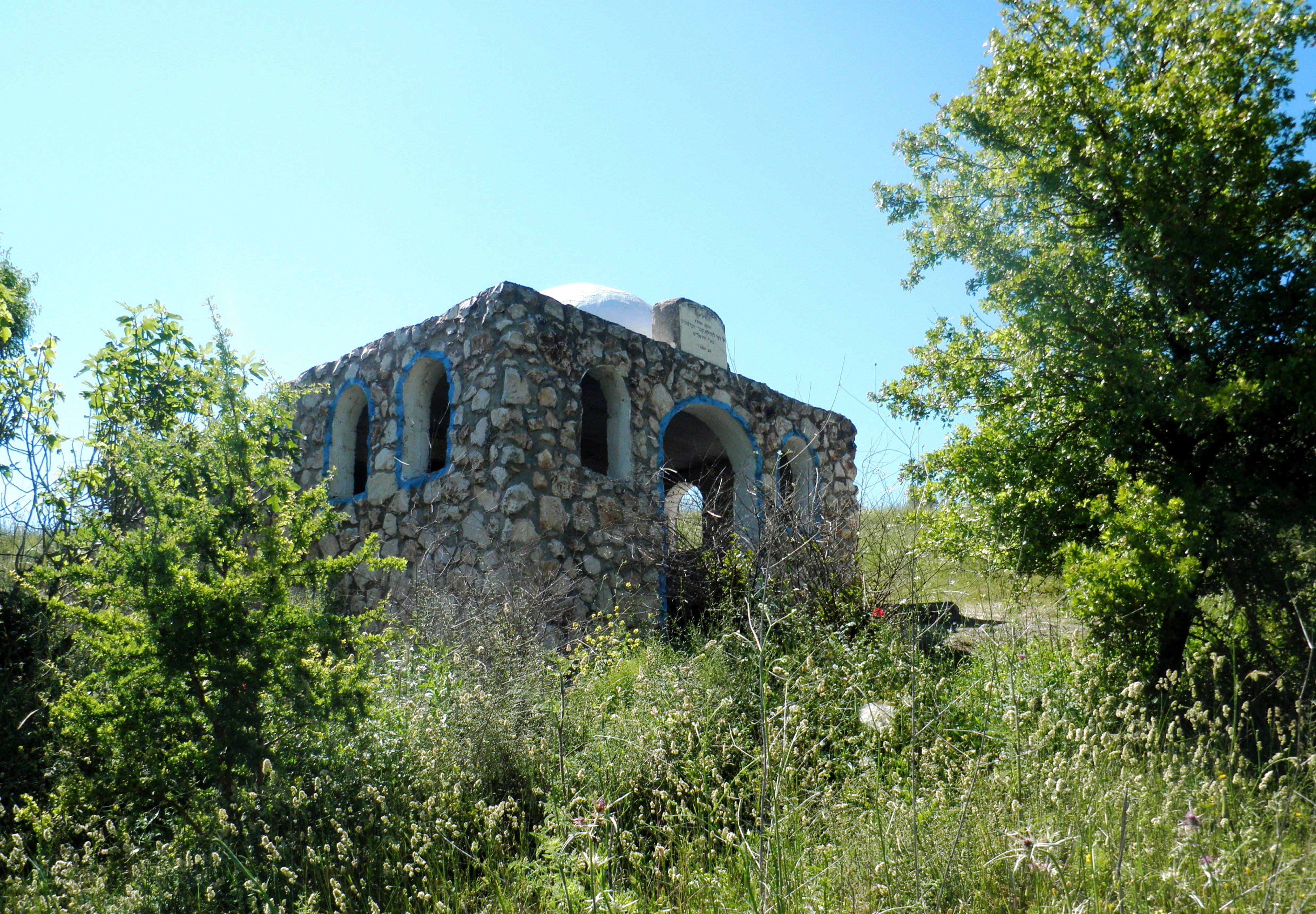
The tombs of Shmaya and Abtalion, a pair of Jewish sages who taught in Jerusalem in the early 1st century BCE, are located in Jish.
According to tradition, the Israelite prophet Joel was also buried there. The structure traditionally believed to be his tomb is situated on the western outskirts of the modern village, and contains several ancient rock-cut tombs.
According to Christian tradition, the parents of Saint Paul were from Jish. John of Giscala, the son of Levi, was born in Jish. Other churches in Jish are a small Maronite Church that was rebuilt after the 1837 earthquake and the Elias Church, the largest in the village, which operates a convent.
Archaeology


Eighteen archaeological sites have been excavated to date in Jish and vicinity. Archaeologists have excavated two synagogues in use since the Roman and Byzantine periods (3rd to 6th centuries CE). One synagogue is located at the top of the village and the other east of it. On the remains of the upper synagogue, found by Kitchener of the Palestine Exploration Fund, the Melkite Greek Catholic Church of Mar Boutros was built. Jewish-Christian amulets were discovered nearby.
Coins indicate that Jish had strong commercial ties with the nearby city of Tyre. On Jish's western slope, a mausoleum was excavated, with stone sarcophagi similar to those seen at the large Jewish catacomb at Beit She'arim National Park. The inner part of the mausoleum contained ten hewn loculi, burial niches known in Hebrew as kokhim. In the mausoleum, archaeologists found several skeletons, oil lamps and a glass bottle dating to the fourth century CE.
A network of secret caves and passageways in Jish, some of them located under private homes, is strikingly similar to hideaways in the Judean lowlands used during the Bar Kokhba revolt.
References
Bibliography
- Gelber, Y. (2001), Palestine 1948, Sussex Academic Press
- (p. 94 ff)
- (reprinted in 1980)
References
- Palmer, 1881, p. [https://archive.org/stream/surveyofwesternp00conduoft#page/76/mode/1up 76 ]
- Conder and Kitchener, 1881, SWP I, p. [https://archive.org/stream/surveyofwesternp01conduoft#page/225/mode/1up 225]
- Yoav Stern. (30 July 2007). "Galilee villages launch campaign to attract Christian pilgrims". [[Haaretz]].
- YNET [http://www.ynet.co.il/articles/0,7340,L-3994394,00.html] ''On the slopes of a hill, at an elevation of 860 meters surrounded by cherry orchards, pears and apples, built houses, especially church building looks from afar. Number of inhabitants 3,000 divided by 55% Maronite Christian, 30% Greek Catholics and the rest are Muslims.''
- "Population". Jish local council.
- ''Encyclopedia Judaica,'' Jerusalem, 1978, "Giscala," vol. 7, 590
- Morris, 2004, p. [https://books.google.com/books?id=uM_kFX6edX8C&pg=PA508 508]
- (24 September 2011). "The Aramaic language is being resurrected in Israel". Vatican Insider - [[La Stampa]].
- (2012-05-28). "Pair of villages in Holy Land teaching Aramaic in effort to revive language that Jesus spoke".
- Hulot & Rabot, "Actes de la societé géographie," Seance du 6 décembre 1907, La Géographie, Volume 17, Paris, 1908, page 78
- Elizabeth A. Livingstone. (1989). "Papers Presented to the Tenth International Conference on Patristic Studies Held in Oxford, 1987: Historica, theologica, gnostica, Biblica et Apocrypha". Peeters Publishers.
- ''[[Mishnah. The Mishnah]]'', (ed.) [[Herbert Danby]], ''Arakhin'' [https://archive.org/stream/DanbyMishnah#page/n581 9:6 (p. 553 - note 9)]
- ''The Guide to Israel'', [[Zev Vilnay]], Jerusalem, 1972, p. 539.
- "el-Jish/Gush Halav".
- [[Pesikta de-Rav Kahana]] (1949), p. 94a
- (1921). "The Origin of Paul's Religion". The MacMillan Company.
- Jerome. "De Viris Illustribus".
- Jerome. "Commentaria in Epistolam ad Philemonem".
- [https://books.google.com/books?id=x8LRPQp_-y8C&pg=PA68 Redefining ancient borders: The Jewish scribal framework of Matthew's Gospel, Aaron M. Gale]
- [https://books.google.com/books?id=Q-vWh51B1AMC&pg=PA22 ''Excavations at the ancient synagogue of Gush Ḥalav'', Eric M. Meyers, Carol L. Meyers, James F. Strange]
- Hachlili, Rachel. (2013). "Ancient Synagogues - Archaeology and Art: New Discoveries and Current Research". BRILL.
- both Jewish and Christian amulets have also been discovered nearby.[https://books.google.com/books?id=GQ-1OsGWvw8C&pg=PA14 The missing century: Palestine in the fifth century: growth and decline, Zeev Safrai]
- Eliya Ribak. (2007). "Religious Communities in Byzantine Palestina". Archaeopress.
- Al-Muqaddasi. (1885). "Description of Syria".
- A. Asher. (c. 1840). "The Itinerary of Rabbi Benjamin of Tudela". Hakesheth.
- Stepansky, Yosef. (1999). "The 'Yeshivat Geon Yaakov' Inscription from Gush Halav: An Archaeological Find that Sheds Light on Medieval Galilean Jewry". Cathedra: For the History of Eretz Israel and Its Yishuv.
- Hütteroth and Abdulfattah, 1977, p. 176
- Note that Rhode, 1979, p. [https://www.academia.edu/2026845/The_Administration_and_Population_of_the_Sancak_of_Safed_in_the_Sixteenth_Century 6] {{Webarchive. link. (2019-04-20 writes that the register that Hütteroth and Abdulfattah studied was not from 1595/6, but from 1548/9)
- בן-צבי, יצחק. (1966). "שאר ישוב". [[Yad Ben Zvi]] יד בן צבי.
- [http://zadok.org/research/1927/landslides.html Damage Caused By Landslides During the Earthquakes of 1837 and 1927 in the Galilee Region]
- Robinson and Smith, 1841, vol. 3. pp. [https://archive.org/stream/biblicalresearch03robiuoft#page/368/mode/1up 368]-369
- Robinson and Smith, 1841, vol 3, 2nd appendix, p. [https://archive.org/stream/biblicalresearch03robiuoft#page/134/mode/1up 134]
- Conder and Kitchener, 1881, SWP I, p. [https://archive.org/stream/surveyofwesternp01conduoft#page/198/mode/1up 198]
- Schumacher, 1888, p. [https://archive.org/stream/quarterlystateme19pale#page/n214/mode/1up 189]
- Barron, 1923, Table XI, Sub-district of Safad, p. [https://archive.org/stream/PalestineCensus1922/Palestine%20Census%20%281922%29#page/n43/mode/1up 41]
- Barron, 1923, Table XVI, p. [https://archive.org/stream/PalestineCensus1922/Palestine%20Census%20%281922%29#page/n53/mode/1up 51]
- Mills, 1932, p. [https://archive.org/details/CensusOfPalestine1931.PopulationOfVillagesTownsAndAdministrativeAreas 107]
- Department of Statistics, 1945, p. [http://users.cecs.anu.edu.au/~bdm/yabber/census/VSpages/VS1945_p09.jpg 09]
- Government of Palestine, Department of Statistics. ''Village Statistics, April, 1945.'' Quoted in Hadawi, 1970, p. [http://www.palestineremembered.com/download/VillageStatistics/Table%20I/Safad/Page-070.jpg 70]
- Government of Palestine, Department of Statistics. ''Village Statistics, April, 1945.'' Quoted in Hadawi, 1970, p. [http://www.palestineremembered.com/download/VillageStatistics/Table%20II/Safad/Page-119.jpg 119]
- Government of Palestine, Department of Statistics. ''Village Statistics, April, 1945.'' Quoted in Hadawi, 1970, p. [http://www.palestineremembered.com/download/VillageStatistics/Table%20III/Safad/Page-169.jpg 169]
- Morris, 2004, p. [https://books.google.com/books?id=uM_kFX6edX8C&pg=PA473 473]
- Morris 2004
- Morris, 2004, p. [https://books.google.com/books?id=uM_kFX6edX8C&pg=PA481 481], citing Israeli sources but noting their lack of clarity
- Gelber, 2001, p.226
- Morris, 2008, p. 345
- Morris, Benny. (2004). "The birth of the Palestinian refugee problem revisited". Cambridge Univ. Press.
- where today they are citizens of Israel, but continue to press for their [[right of return]] to their former villages. In October 1950, Israeli forces raided Jish and detained seven suspected smugglers who were stripped, bound, and beaten. They were released without charge.Morris, 1993, p. 167
- (2003). "Blood Brothers". Chosen Books.
- [https://www.jpost.com/GreenIsrael/PEOPLEANDTHEENVIRONMENT/Article.aspx?id=201417 Galilee Coexistence Trail Inaugurated], [[Jerusalem Post]]
- [https://www.jewishvirtuallibrary.org/jsource/Society_&_Culture/geo/Gush_HaLav.html Gush Halav]
- Cinamon, G. (2013). Gush Halav. ''Hadashot Arkheologiyot: Excavations and Surveys in Israel/חדשות ארכיאולוגיות: חפירות וסקרים בישראל''.
- [https://books.google.com/books?id=Q-vWh51B1AMC&dq=st.+paul+gush+halav&pg=PA22 Galilee villages launch campaign to attract Christian pilgrims]
- [http://www.iaa-conservation.org.il/Projects_Item_eng.asp?id=50&subject_id=6&site_id=27 Projects - Preservation]
- [[C. R. Conder. Conder]] and [[HH Kitchener. Kitchener]] (1881), p. [https://archive.org/stream/surveyofwesternp01conduoft#page/224/mode/1up 224]
- [http://www.eretz.com/NEW/article/jish.html ERETZ Magazine]
This article was imported from Wikipedia and is available under the Creative Commons Attribution-ShareAlike 4.0 License. Content has been adapted to SurfDoc format. Original contributors can be found on the article history page.
Ask Mako anything about Jish — get instant answers, deeper analysis, and related topics.
Research with MakoFree with your Surf account
Create a free account to save articles, ask Mako questions, and organize your research.
Sign up freeThis content may have been generated or modified by AI. CloudSurf Software LLC is not responsible for the accuracy, completeness, or reliability of AI-generated content. Always verify important information from primary sources.
Report