From Surf Wiki (app.surf) — the open knowledge base
Ismailia Governorate
Governorate of Egypt

Governorate of Egypt
| Field | Value | |
|---|---|---|
| <!-- See Template:Infobox settlement for additional fields and descriptions --> | name | Ismailia Governorate |
| settlement_type | Governorate | |
| image_flag | Governadorat d'Ismailiya.png | |
| flag_size | 120px | |
| image_blank_emblem | Emblem Ismailia Governorate.jpg | |
| blank_emblem_size | 75px | |
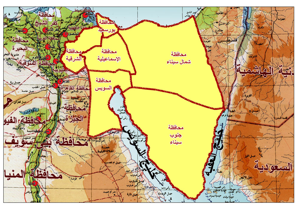
| image_map | Ismailia in Egypt (2011).svg | |
| map_caption | Ismailia Governorate on the map of Egypt | |
| subdivision_type | Country | |
| subdivision_name | ||
| seat | Ismailia (capital) | |
| leader_title | Governor | |
| leader_name | Akram Mohamed Galal | |
| area_footnotes | ||
| area_total_km2 | 5,066 | |
| population_footnotes | ||
| population_total | 1479511 | |
| population_as_of | January 2023 | |
| population_density_km2 | auto | |
| demographics_type1 | GDP | |
| demographics1_footnotes | ||
| demographics1_title1 | Total | |
| demographics1_info1 | EGP 91 billion | |
| (US$ 5.8 billion) | ||
| timezone1 | EGY | |
| utc_offset1 | +2 | |
| timezone1_DST | EEST | |
| utc_offset1_DST | +3 | |
| blank_name_sec2 | HDI (2021) | |
| blank_info_sec2 | 0.745 | |
| · 8th | ||
| website |
(US$ 5.8 billion) · 8th
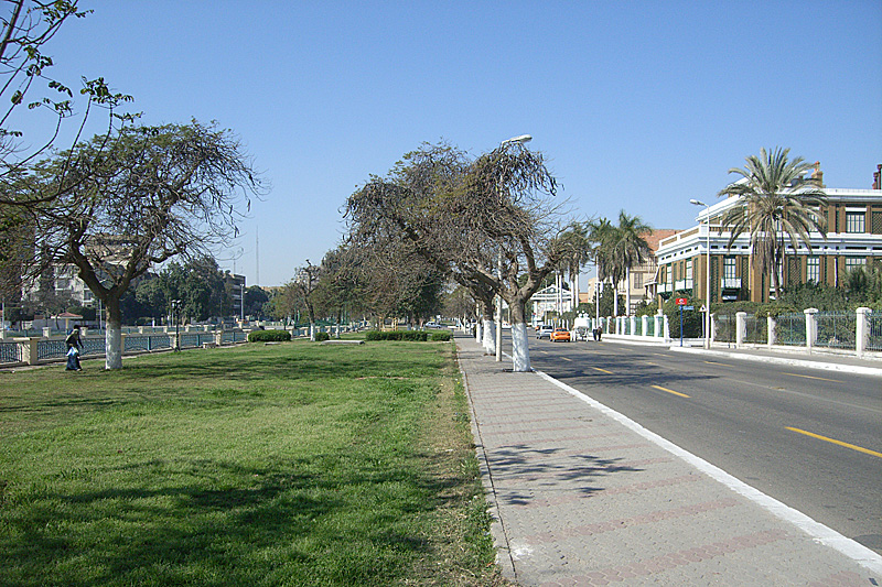
Ismailia () is one of the Canal Zone governorates of Egypt. Located in the northeastern part of the country, its capital is the city of Ismailia. It was named after Ismail Pasha, who as Ottoman Viceroy of Egypt, oversaw the country during the building of the Suez Canal. It is located between the other two Canal governorates; Port Said Governorate, in the Northern part of Egypt and Suez Governorate.
.jpg)
|1966 | 345,000 |1976 | 351,889 |1986 | 544,427 |1996 | 715,009 |2006 | 942,832 |2015 |1,178,641 |2023 |1,442,402 |align-fn=center
Municipal divisions
The governorate is divided into municipal divisions, with a total estimated population as of January 2023 of 1,479,511. In the case of Ismailia governorate, there are 4 kism, 5 markaz and 1 new city.
The divisions are generally seven: Ismailia which is the capital, Tell El Kebir, Abu Suwir, Qassasin, Fayid, Qantara West and Qantara East.
| Anglicized name | Native name | Arabic transliteration | Population | |
|---|---|---|---|---|
| (July 2017 Est.) | Type | |||
| Abu Suwir | مركز أبو صوير | ar | 221,994 | Markaz |
| Ismailia | مركز الاسماعيلية | ar | 170,065 | Markaz |
| Ismailia 1 | قسم أول الاسماعيلية | ar | 49,859 | Kism (fully urban) |
| Ismailia 2 | قسم ثان الاسماعيلية | ar | 264,376 | Kism (fully urban) |
| Ismailia 3 | قسم ثالث الاسماعيلية | ar | 131,422 | Kism (fully urban) |
| El Qantara West | مركز القنطرة غرب | ar | 162,101 | Markaz |
| El Qantara El Sharqiya | مركز القنطرة شرق | ar | 62,600 | Markaz |
| New Kasaseen | مركز القصاصين الجديده | ar | 120,788 | New City |
| Tell El Kebir | مركز التل الكبير | ar | 111,635 | Markaz |
| Fayid | مركز فايد | ar | 147,562 | Markaz |
Population
According to population estimates, in 2015 the majority of residents in the governorate lived in rural areas, with an urbanization rate of only 45.4%. Out of an estimated 1,479,511 people residing in the governorate, 807,813 people lived in rural areas as opposed to only 671,678 in urban areas.
Cities and towns
As of 2017, seven cities (or towns) in Ismailia had a population of over 15,000 inhabitants.
| Anglicized name | Native name | Arabic transliteration | Nov. 1996 Census | Nov. 2006 Census | Population |
|---|---|---|---|---|---|
| (July 2017 Est.) | |||||
| Abu Suwir El Mahata | أبو صوير المحطة | ar | 18,331 | 24,265 | 29,476 |
| Ismalia | الإسماعيلية | ar | 255,134 | 293,184 | 386,372 |
| New Kasaseen | القصاصين الجديدة | ar | 11,948 | 15,611 | 22,000 |
| Tell El Kebir | التل الكبير | ar | 31,410 | 26,891 | 37,000 |
| Fayid | فايد | ar | 15,652 | 21,808 | 31,545 |
Industrial zones
According to the Governing Authority for Investment and Free Zones (GAFI), the following industrial zones are located in Isamilia:
| Zone name |
|---|
| Abo Khalifa Industrial Zone |
| East Qantra Industrial Zone |
| First and Second Industrial Zone |
| Technology Valley Industrial Zone |
Annual film festival
Hashim El Nahas founded the Ismailia International Film Festival for Documentaries and Shorts and originally considered establishing it in Luxor. Instead this festival has been celebrating its annual events in Ismailia Governorate. It is sponsored by the Ministry of Culture, Ismailia Governorate, The National Cinema Center and other sponsors.
Ismailia Canal
The Ismailia Governorate is on the banks of the Suez Canal and its Ismailia Canal extends from the Nile River near Cairo to the Suez Canal at the city of Ismailia, on Lake Timsah. The Ismailia Canal was built to provide fresh water to workers during the building of the Suez Canal. The Suez Canal Authority headquarters is located in Ismailia.
Conflicts and wars
From 1967 to 1970, Ismailia became a war zone and was damaged in the conflict with Israel. Many battles were fought, in and around Ismailia, including at the end of the conflict in the Battle of Ismailia and the area was able to begin rebuilding after a cease-fire was negotiated between Egypt and Israel in 1973.
Fishing landing sites
There are several official fishing landing sites in Ismailia. One is at Lake Timsah and the other at Bitter Lake.
UN sustainable programme
After a successful SIP (Sustainable Ismailia Programme) from 1992 to 1997, the United Nations expanded the project to include the entire Governorate of Ismailia calling it SGIP (Sustainable Ismailia Governorate Programme). Its goal is to work with local partners to improve the communities in Ismailia.
References
References
- (4 July 2024). "Egypt Announces New Governors for Cairo, Alexandria and Other Cities {{!}} Egyptian Streets".
- "Ismailia Governorate Subdivisions".
- "About the governorate".
- link
- "GDP BY GOVERNORATE".
- "Sub-national HDI - Subnational HDI - Table - Global Data Lab".
- "Ismail-Pasha".
- "Ismailia Population, 1966–2006". Statoids.
- "الجهاز المركزي للتعبئة العامة والإحصاء".
- (January 2020). "Ismailia site". Ismailia Government }}{{Dead link.
- "Map of Ismailia". Ismailia Government.
- "Population Estimates By Sex & Governorate 1/1/2015".
- "Cities".
- "Industrial Zones of Governorate".
- "Ismailia International Film Festival For Documentaries and Shorts".
- (1997). "Merriam Webster's Geographical Dictionary". Merriam-Webster.
- "Al-Ismailiyyah".
- "Suez Canal".
- (20 November 2012). "The Yom Kippur War 1973 (2): The Sinai". Bloomsbury Publishing.
- (2015). "Wars That Changed History: 50 of the World's Greatest Conflicts". ABC-CLIO.
- (2016). "Understanding War: An Annotated Bibliography". UPA.
- "Fishery and Aquaculture Country Profiles The Arab Republic of Egypt".
- "Information on Fisheries Management in the Arab Republic of Egypt".
- (2002). "Sustainable Cities Programme 1990-2000: A Decade of United Nations Support for Broad-based Participatory Management of Urban Development". UN.
This article was imported from Wikipedia and is available under the Creative Commons Attribution-ShareAlike 4.0 License. Content has been adapted to SurfDoc format. Original contributors can be found on the article history page.
Ask Mako anything about Ismailia Governorate — get instant answers, deeper analysis, and related topics.
Research with MakoFree with your Surf account
Create a free account to save articles, ask Mako questions, and organize your research.
Sign up freeThis content may have been generated or modified by AI. CloudSurf Software LLC is not responsible for the accuracy, completeness, or reliability of AI-generated content. Always verify important information from primary sources.
Report