From Surf Wiki (app.surf) — the open knowledge base
Isle of Skye
Island of the Inner Hebrides, Scotland

Island of the Inner Hebrides, Scotland
| Field | Value |
|---|---|
| Map | Isle of Skye UK relief location map.jpg |
| GridReference | NG452319 |
| coordinates | |
| image_flag | Flag of the Isle of Skye.svg |
| Image | Bank Street, Port Righ (Portree) - geograph.org.uk - 1353645.jpg |
| ImageCaption | Bank Street, Portree |
| celtic name | An t-Eilean Sgitheanach |
| gaelic pronunciation | |
| norse name | Skíð |
| meaning of name | Etymology unclear |
| area | 1656 km2 |
| area rank | 2 |
| highest elevation | Sgùrr Alasdair, 993 m |
| Population | 10,496 |
| population rank | 4 |
| population density | 6.34 PD/km2 |
| main settlement | Portree |
| island group | Skye |
| local authority | Highland |
| references |
The Isle of Skye, or simply Skye, is the largest and northernmost of the major islands in the Inner Hebrides of Scotland. The island's peninsulas radiate from a mountainous hub dominated by the Cuillin, the rocky slopes of which provide some of the most dramatic mountain scenery in the country. Although Sgitheanach has been suggested to describe a winged shape, no definitive agreement exists as to the name's origin.
The island has been occupied since the late Upper Palaeolithic period, and over its history has been occupied at various times by Celtic tribes including the Picts and the Gaels, Scandinavian Vikings, and most notably the powerful integrated Norse-Gaels clans of MacLeod and MacDonald. The island was considered to be under Norwegian suzerainty until the 1266 Treaty of Perth, which transferred control over to Scotland.
The 18th-century Jacobite risings led to the breaking-up of the clan system and later clearances that replaced entire communities with sheep farms, some of which involved forced emigrations to distant lands. Resident numbers declined from over 20,000 in the early 19th century to just under 9,000 by the closing decade of the 20th century. Skye's population increased by 4% between 1991 and 2001. About a third of the residents were Gaelic speakers in 2001, and although their numbers are in decline, this aspect of island culture remains important. The main industries are tourism, agriculture, fishing, and forestry. Skye is part of the Highland Council local government area and wholly within the historic county of Inverness-shire. The island's largest settlement is Portree, which is also its capital, known for its picturesque harbour. Links to various nearby islands by ferry are available, and since 1995, to the mainland by the Skye Bridge. The climate is mild, wet, and windy. The abundant wildlife includes the golden eagle, red deer, and Atlantic salmon. The local flora is dominated by heather moor, and nationally important invertebrate populations live on the surrounding sea bed. Skye has provided the locations for various novels and feature films and is celebrated in poetry and song.
Etymology
Main article: Etymology of Skye
The first written references to the island are Roman sources such as the Ravenna Cosmography, which refers to Scitis and Scetis, which can be found on a map by Ptolemy. One possible derivation comes from skitis, an early Celtic word for "winged", which may describe how the island's peninsulas radiate out from a mountainous centre. Subsequent Gaelic-, Norse- and English-speaking peoples have influenced the history of Skye; the relationships between their names for the island are not straightforward. Various etymologies have been proposed, such as the "winged isle" or "the notched isle", but no definitive solution has been found to date; the place name may be from an earlier, non-Gaelic language.
In the Norse sagas, Skye is called Skíð, for example in the Hákonar saga Hákonarsonar and a skaldic poem in the Heimskringla from around 1230 contains a line that translates as "the hunger battle-birds were filled in Skye with the blood of foemen killed". The island was also referred to by the Norse as Skuy (misty isle),|group="Note"}} The meaning of this Gaelic name is unclear.
Eilean a' Cheò, which means "island of the mist" (a translation of the Norse name), is a poetic Gaelic name for the island.|group="Note"}}
Geography


At 1656 km2, Skye is the second-largest island in Scotland after Lewis and Harris. The coastline of Skye is a series of peninsulas and bays radiating out from a centre dominated by the Cuillin hills (Gaelic: An Cuiltheann). Malcolm Slesser suggested that its shape "sticks out of the west coast of northern Scotland like a lobster's claw ready to snap at the fishbone of Harris and Lewis" and W. H. Murray, commenting on its irregular coastline, stated, "Skye is 60 miles [100 km] long, but what might be its breadth is beyond the ingenuity of man to state". Martin Martin, a native of the island, reported on it at length in a 1703 publication. His geological observations included a note that:
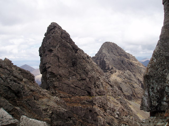
The Black Cuillin, which are mainly composed of basalt and gabbro, include 12 Munros and provide some of the most dramatic and challenging mountain terrain in Scotland. Nearby Sgùrr Alasdair, meanwhile, is the tallest mountain on any Scottish island. These hills make demands of the hill walker that exceed any others found in Scotland and a full traverse of the Cuillin ridge may take 15–20 hours. The Red Hills (Gaelic: Am Binnean Dearg) to the east are also known as the Red Cuillin. They are mainly composed of granite that has weathered into more rounded hills with many long scree slopes on their flanks. The highest point of these hills is Glamaig, one of only two Corbetts on Skye.
The northern peninsula of Trotternish is underlain by basalt, which provides relatively rich soils and a variety of unusual rock features. The Kilt Rock is named after the columnar structure of the ~70 m cliffs, said to resemble the pleats in a kilt. The Quiraing is a spectacular series of rock pinnacles on the eastern side of the main spine of the peninsula and further south is the rock pillar of the Old Man of Storr. The view of the Quiraing and the Old Man of Storr is one of the most iconic in all of Scotland and is frequently used on calendars and tourism guides and brochures.
Beyond Loch Snizort to the west of Trotternish is the Waternish peninsula, which ends in Ardmore Point's double rock arch. Duirinish peninsula is separated from Waternish by Loch Dunvegan, which contains the island of Isay. It is ringed by sea cliffs that reach 296 m on the west at Waterstein Head and on the northwest at Biod an Athair where, a metre from the summit trig pillar, the cliffs drop 1029 ft to the ocean. Oolitic loam provides good arable land in the main valley. Lochs Bracadale and Harport and the island of Wiay lie between Duirinish and Minginish, which includes the narrower defiles of Talisker and Glen Brittle and whose beaches are formed from black basaltic sands. Strathaird is a relatively small peninsula close to the Cuillin hills with only a few crofting communities, the island of Soay lies offshore. The bedrock of Sleat in the south is Torridonian sandstone, which produces poor soils and boggy ground, although its lower elevations and relatively sheltered eastern shores enable a lush growth of hedgerows and crops. The islands of Raasay, Rona, Scalpay and Pabay all lie to the north and east between Skye and the mainland.
Palaeontology
The Isle of Skye has a rich palaeontological record of Jurassic aged strata. The Trotternish peninsula in northeast Skye is renowned for its Middle Jurassic aged rock (circa 174-166 million years old), which has provided researchers with the opportunity to study dinosaur footprints and bones. The first scientifically described dinosaur footprint was discovered in 1982 and likely impressed by either a large theropod or ornithopod dinosaur. Later discoveries have included further footprints and bones. The first dinosaur bone (a tibia) was found in 1992 in Early Jurassic deposits in southern Skye and most likely belonged to a small Coelophysoid theropod. Subsequent Middle Jurassic aged bones found belonged to large theropods (a middle caudal vertebra and many teeth), sauropods (many vertebra, a couple of teeth, and a humerus), and thyreophorans (partial radius and ulna). Footprints for all these dinosaurs have been recorded in-situ across Trotternish at Brother's Point, An Corran (Staffin Bay), and Duntulm. Evidence of stegosaurs is noted in tracks from Brother's Point. A selection of Skye's palaeontological heritage is exhibited in the Staffin Museum in Ellishadder, Staffin. All dinosaur and vertebrate related fossils on Skye are protected by law by the Skye Nature Conservation Order 2019.
Towns and villages

Portree in the north at the base of Trotternish is the largest settlement (estimated population 2,264 in 2011) and is the main service centre on the island. A December 2018 report recommended the village as "Skye's best home base" for visitors", since it has "a few hotels, hostels and bed-and-breakfasts in town, while more B&Bs line the roads into and out of town". The village also has "banks, churches, cafes and restaurants, a cinema at the Aros Centre, a swimming pool and library ... fuel filling stations and supermarkets".
Broadford, the location of the island's only airstrip, is on the east side of the island, and Dunvegan in the north-west is well known for its castle and the nearby Three Chimneys restaurant. The 18th-century Stein Inn on the Waternish coast is the oldest pub on Skye. Kyleakin is linked to Kyle of Lochalsh on the mainland by the Skye Bridge, which spans the narrows of Loch Alsh. Uig, the port for ferries to the Outer Hebrides, is on the west of the Trotternish peninsula, and Edinbane is between Dunvegan and Portree.
Climate
The influence of the Atlantic Ocean and the Gulf Stream create a mild oceanic climate. Temperatures are generally cool, averaging 6.5 °C in January and 15.4 °C in July at Duntulm in Trotternish.|group="Note"}} Snow seldom lies at sea level and frosts are less frequent than on the mainland. Winds are a limiting factor for vegetation. South-westerlies are the most common and speeds of 128 km/h have been recorded. High winds are especially likely on the exposed coasts of Trotternish and Waternish. In common with most islands of the west coast of Scotland, rainfall is generally high at 1500 - per annum and the elevated Cuillin are wetter still. Trotternish typically has 200 hours of bright sunshine in May, the sunniest month. On 28 December 2015, the temperature reached 15 °C, beating the previous December record of 12.9 °C, set in 2013. On 9 May 2016, a temperature of 26.7 °C (80.1 °F) was recorded at Lusa in the southeast of the island.
|Jan record high C= 13.5 |Feb record high C= 12.5 |Mar record high C= 16.7 |Apr record high C= 22.3 |May record high C= 26.7 |Jun record high C= 24.5 |Jul record high C= 25.9 |Aug record high C= 25.6 |Sep record high C= 22.1 |Oct record high C= 19.3 |Nov record high C= 17.3 |Dec record high C= 15.0 |year record high C= 26.7 |Jan record low C= -4.0 |Feb record low C= -3.5 |Mar record low C= -4.1 |Apr record low C= -3.4 |May record low C= 0.0 |Jun record low C= 4.2 |Jul record low C= 5.2 |Aug record low C= 4.7 |Sep record low C= 2.6 |Oct record low C= 0.3 |Nov record low C= -4.5 |Dec record low C= -6.5 |year record low C= -6.5
History
Prehistory
The oldest evidence of human presence on Skye is late Upper Palaeolithic stone tools of Ahrensburgian-type found at South Cuidrach on the far north of Skye. No organic material was found in connection to the tools to directly date them, but the timing of the Ahrensburgian culture elsewhere suggests a date roughly corresponding to the end of the Late Pleistocene and beginning of the Holocene, around 12,500-11,000 years ago.
A Mesolithic hunter-gatherer site dating to the seventh millennium BC at An Corran in Staffin is one of the oldest archaeological sites in Scotland. Its occupation is probably linked to that of the rock shelter at Sand, Applecross, on the mainland coast of Wester Ross, where tools made of a mudstone from An Corran have been found. Surveys of the area between the two shores of the Inner Sound and Sound of Raasay have revealed 33 sites with potentially Mesolithic deposits. Finds of bloodstone microliths on the foreshore at Orbost on the west coast of the island near Dunvegan also suggest Mesolithic occupation. These tools probably originated from the nearby island of Rùm. Similarly, bloodstone from Rum, and baked mudstone, from the Staffin area, were found at the Mesolithic site of Camas Daraich, also from the seventh millennium BC, on the Point of Sleat, which has led archaeologists to believe that Mesolithic people on Skye would travel fairly significant distances, at least 70 km, both by land and sea.

Rubha an Dùnain, an uninhabited peninsula to the south of the Cuillin, has a variety of archaeological sites dating from the Neolithic onwards. A second- or third-millennium BC chambered cairn, an Iron Age promontory fort, and the remains of another prehistoric settlement dating from the Bronze Age are nearby. Loch na h-Airde on the peninsula is linked to the sea by an artificial "Viking" canal that may date from the later period of Norse settlement. Dun Ringill is a ruined Iron Age hill fort on the Strathaird Peninsula, which was further fortified in the Middle Ages and may have become the seat of Clan MacKinnon.
Early history
The late Iron Age inhabitants of the northern and western Hebrides were probably Pictish, although the historical record is sparse. Three Pictish symbol stones have been found on Skye and a fourth on Raasay. More is known of the kingdom of Dál Riata to the south; Adomnán's life of Columba, written shortly before 697, portrays the saint visiting Skye (where he baptised a pagan leader using an interpreter) and Adomnán himself is thought to have been familiar with the island. The Irish annals record several events on Skye in the later seventh and early eighth centuries – mainly concerning the struggles between rival dynasties that formed the background to the Old Irish language romance Scéla Cano meic Gartnáin.
Legendary hero Cú Chulainn is said to have trained on the Isle of Skye with warrior woman Scáthach.
The Norse held sway throughout the Hebrides from the 9th century until after the Treaty of Perth in 1266. However, apart from placenames, little remains of their presence on Skye in the written or archaeological record. Apart from the name "Skye" itself, all pre-Norse placenames seem to have been obliterated by the Scandinavian settlers. Viking heritage, with Celtic heritage is claimed by Clan MacLeod. Norse tradition is celebrated in the winter fire festival at Dunvegan, during which a replica Viking longboat is set alight.
Clans and Scottish rule
The most powerful clans on Skye in the post–Norse period were Clan MacLeod, originally based in Trotternish, and Clan Macdonald of Sleat. The isle was held by Donald Macdonald, Lord of the Isles' half-brother, Godfrey, from 1389 until 1401, at which time Skye was declared part of Ross. When Donald Macdonald, Lord of the Isles, re-gained Ross after the battle of Harlaw in 1411, they added "Earl of Ross" to their lords' titles. Skye came with Ross.
Following the disintegration of the Lordship of the Isles in the late 15th century, Clan Mackinnon also emerged as an independent clan, whose substantial landholdings in Skye were centred on Strathaird. Clan MacNeacail also have a long association with Trotternish, and in the 16th century many of the MacInnes clan moved to Sleat. The MacDonalds of South Uist were bitter rivals of the MacLeods, and an attempt by the former to murder church-goers at Trumpan Church in retaliation for a previous massacre on Eigg, resulted in the Battle of the Spoiling Dyke of 1578.

After the failure of the Jacobite rebellion of 1745, Flora MacDonald became famous for rescuing Prince Charles Edward Stuart from the Hanoverian troops. Although she was born in South Uist, her story is strongly associated with their escape via Skye, and she is buried at Kilmuir in Trotternish. Samuel Johnson and James Boswell's visit to Skye in 1773 and their meeting with Flora MacDonald in Kilmuir is recorded in Boswell's The Journal of a Tour to the Hebrides. Boswell wrote, "To see Dr. Samuel Johnson, the great champion of the English Tories, salute Miss Flora MacDonald in the isle of Sky, was a striking sight; for though somewhat congenial in their notions, it was very improbable they should meet here". Johnson's words that Flora MacDonald was "A name that will be mentioned in history, and if courage and fidelity be virtues, mentioned with honour" are written on her gravestone. After this rebellion, the clan system was broken up and Skye became a series of landed estates.
Of the island in general, Johnson observed:
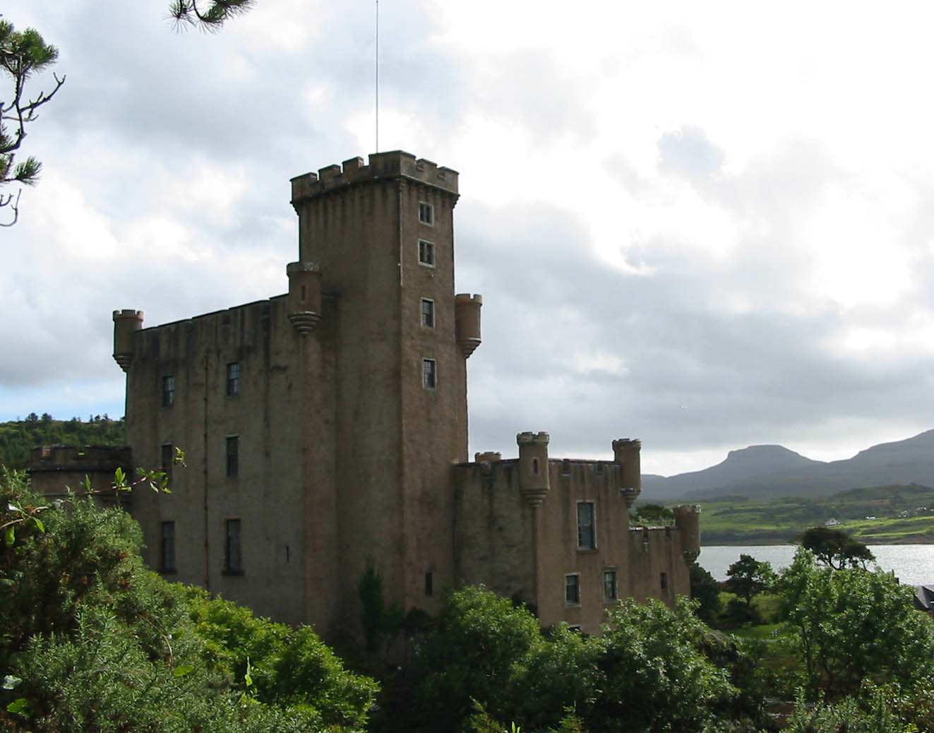
Skye has a rich heritage of ancient monuments from this period. Dunvegan Castle has been the seat of Clan MacLeod since the 13th century. It contains the Fairy Flag and is reputed to have been inhabited by a single family for longer than any other house in Scotland. The 18th-century Armadale Castle, once the home of Clan Donald of Sleat, was abandoned as a residence in 1925, but now hosts the Clan Donald Centre. Nearby are the ruins of two more MacDonald strongholds, Knock Castle, and Dunscaith Castle (called "Fortress of Shadows"), the legendary home of warrior woman, martial arts instructor (and, according to some sources, Queen) Scáthach. Caisteal Maol, a fortress built in the late 15th century near Kyleakin and once a seat of Clan MacKinnon, is another ruin.
Economic turmoil and mass emigration

Overview of population trends
| Year | 1755 | 1794 | 1821 | 1841 | 1881 | 1891 | 1931 | 1951 | 1961 | 1971 | 1981 | 1991 | 2001 | 2011 | 2022 |
|---|---|---|---|---|---|---|---|---|---|---|---|---|---|---|---|
| Population | 11,252 | 14,470 | 20,827 | 23,082 | 16,889 | 15,705 | 9,908 | 8,537 | 7,479 | 7,183 | 7,276 | 8,847 | 9,232 | 10,008 | 10,496 |
As with many Scottish islands, Skye's population peaked in the 19th century and then declined under the impact of the Clearances and the military losses in the First World War. From the 19th century until 1975 Skye was part of the county of Inverness-shire, but the crofting economy languished and according to Slesser, "Generations of UK governments have treated the island people contemptuously"—a charge that has been levelled at both Labour and Conservative administrations' policies in the Highlands and Islands. By 1971 the population was less than a third of its peak recorded figure in 1841. However, the number of residents then grew by over 28 percent in the thirty years to 2001. The changing relationship between the residents and the land is evidenced by Robert Carruthers's remark , "There is now a village in Portree containing three hundred inhabitants." Even if this estimate is inexact the population of the island's largest settlement has probably increased sixfold or more since then. During the period the total number of island residents has declined by 50 percent or more.The island-wide population increase of 4 percent between 1991 and 2001 occurred against the background of an overall reduction in Scottish island populations of 3 percent for the same period. By 2011 the population had risen a further 8.4% to 10,008 with Scottish island populations as a whole growing by 4% to 13,702.
Language
| Pronunciation |
|---|
| Scots Gaelic: |
| Pronunciation: |
| Scots Gaelic: |
| Pronunciation: |
| Scots Gaelic: |
| Pronunciation: |
| Scots Gaelic: |
| Pronunciation: |
| Scots Gaelic: |
| Pronunciation: |
| Scots Gaelic: |
| Pronunciation: |
| Scots Gaelic: |
| Pronunciation: |
| Scots Gaelic: |
| Pronunciation: |
| Scots Gaelic: |
| Pronunciation: |
| Scots Gaelic: |
| Pronunciation: |
| Scots Gaelic: |
| Pronunciation: |
| Scots Gaelic: |
| Pronunciation: |
| Scots Gaelic: |
| Pronunciation: |
Historically, Skye was overwhelmingly Gaelic-speaking, but this changed between 1921 and 2001. In both the 1901 and 1921 censuses, all Skye parishes were more than 75 percent Gaelic-speaking. By 1971, only Kilmuir parish had more than three-quarters of Gaelic speakers while the rest of Skye ranged between 50 and 74 percent. At that time, Kilmuir was the only area outside the Western Isles that had such a high proportion of Gaelic speakers. In the 2001 census Kilmuir had just under half Gaelic speakers, and overall, Skye had 31 percent, distributed unevenly. The strongest Gaelic areas were in the north and southwest of the island, including Staffin at 61 percent. The weakest areas were in the west and east (e.g. Luib 23 percent and Kylerhea 19 percent). Other areas on Skye ranged between 48 percent and 25 percent.
Government and politics
In terms of local government, from 1975 to 1996, Skye, along with the neighbouring mainland area of Lochalsh, constituted a local government district within the Highland administrative area. In 1996 the district was included in the unitary Highland Council, (Comhairle na Gàidhealtachd) based in Inverness and formed one of the new council's area committees. Following the 2007 elections, Skye now forms a four-member ward called Eilean a' Cheò; it is currently represented by two independents, one Scottish National Party, and one Liberal Democrat councillor.
Skye is in the Highlands and Islands electoral region and comprises a part of the Skye, Lochaber and Badenoch constituency of the Scottish Parliament, which elects one member under the first past the post basis to represent it. Kate Forbes is the current MSP for the SNP. In addition, Skye forms part of the wider Ross, Skye and Lochaber constituency, which elects one member to the House of Commons in Westminster.
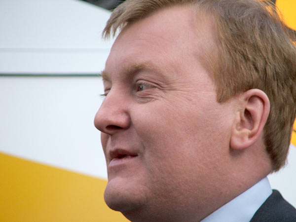
The present Member of Parliament is Liberal Democrat Angus MacDonald, who won his seat at the 2024 general election. Prior to this it was represented by Ian Blackford of the Scottish National Party, who took office after the SNP's sweep in the General Election of 2015. Before this, Charles Kennedy, a Liberal Democrat, had represented the area since the 1983 general election.
There are seven civil parishes on the island, as shown in the map above.
Economy
The largest employer on the island and its environs is the public sector, which accounts for about a third of the total workforce, principally in administration, education, and health. The second-largest employer in the area is the distribution, hotels, and restaurants sector, highlighting the importance of tourism. Key attractions include Dunvegan Castle, the Clan Donald Visitor Centre, and The Aros Experience arts and exhibition centre in Portree. There are about a dozen large landowners on Skye, the largest being the public sector, with the Scottish Government owning most of the northern part of the island. Glendale is a community-owned estate in Duirinish, and the Sleat Community Trust, the local development trust, is active in various regeneration projects.
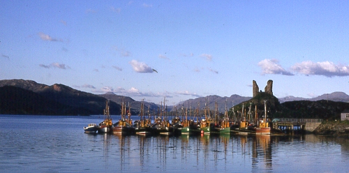
Small firms dominate employment in the private sector. The Talisker Distillery, which produces a single malt whisky, is beside Loch Harport on the west coast of the island. Torabhaig distillery located in Teangue opened in 2017 and also produces whisky. Three other whiskies—Mac na Mara ('son of the sea'), Tè Bheag nan Eilean ('wee dram of the isles') and Poit Dhubh ('black pot')—are produced by blender Pràban na Linne ('smugglers den by the Sound of Sleat'), based at Eilean Iarmain. These are marketed using predominantly Gaelic-language labels. The blended whisky branded as "Isle of Skye" is produced not on the island but by the Glengoyne Distillery at Killearn north of Glasgow, though the website of the owners, Ian Macleod Distillers Ltd., boasts a "high proportion of Island malts" and contains advertisements for tourist businesses in the island. There is also an established software presence on Skye, with Portree-based Sitekit having expanded in recent years.
Crofting is still important, but although there are about 2,000 crofts on Skye only 100 or so are large enough to enable a crofter to earn a livelihood entirely from the land. In recent years, families have complained about the increasing prices for land that make it difficult for young people to start their own crofts.
Cod and herring stocks have declined but commercial fishing remains important, especially fish farming of salmon and crustaceans such as scampi. The west coast of Scotland has a considerable renewable energy potential and the Isle of Skye Renewables Co-op has recently bought a stake in the Ben Aketil wind farm near Dunvegan. There is a thriving arts and crafts sector.
The unemployment rate in the area tends to be higher than in the Highlands as a whole, and is seasonal, in part due to the impact of tourism. The population is growing and in common with many other scenic rural areas in Scotland, significant increases are expected in the percentage of the population aged 45 to 64 years.
The restrictions required by the worldwide pandemic increased unemployment in the Highlands and Islands in the summer of 2020 to 5.7%; which was significantly higher than the 2.4 percent in 2019. The rates were said to be highest in "Lochaber, Skye and Wester Ross and Argyll and the Islands". A December 2020 report stated that between March (just before the effects of pandemic were noted) and December, the unemployment rate in the region increased by "more than 97%" and suggested that the outlook was even worse for spring 2021.
Tourism
.jpg)
Visits to Skye had been steadily increasing prior to COVID-19 pandemic. In 2019, Skye added £211 million in 2019 to the island's economy; Skye and Raasay had some 650,000 visitors in 2018, supporting an estimated 2,850 jobs. The pandemic, and travel restrictions imposed due to it, led to a sharp decline in tourism in Skye and the rest of the Highlands and Islands region. After the pandemic, tourism rebounded; with tourist numbers expected to break records in 2024. The Old Man of Storr is among the island's most popular sites for tourists,
Pre-pandemic, some islanders complained about perceived tourist overcrowding in popular locations, including the Old Man of Storr and Quiraing (both on the Trotternish escarpment) as well as Glen Brittle and Neist Point lighthouse. Post-pandemic, the Rural Tourism Infrastructure Fund funded improvements to visitor infrastructure at Blà Bheinn and the Trotternish Ridge.
Transport
Skye is linked to the mainland by the Skye Bridge, while ferries sail from Armadale on the island to Mallaig, and from Kylerhea to Glenelg, crossing the Kyle Rhea strait on the MV Glenachulish, the last turntable ferry in the world. Turntable ferries had been common on the west coast of Scotland because they do not require much infrastructure to operate, a boat ramp will suffice. Ferries also run from Uig to Tarbert on Harris and Lochmaddy on North Uist, and from Sconser to Raasay.

The Skye Bridge opened in 1995 under a private finance initiative and the high tolls charged (£5.70 each way for summer visitors) met with widespread opposition, spearheaded by the pressure group SKAT (Skye and Kyle Against Tolls). On 21 December 2004, it was announced that the Scottish Executive had purchased the bridge from its owners and the tolls were immediately removed.
Bus services run to Inverness and Glasgow, and there are local services on the island, mainly starting from Portree or Broadford. Train services run from Kyle of Lochalsh at the mainland end of the Skye Bridge to Inverness, as well as from Glasgow to Mallaig from where the ferry can be caught to Armadale.
The island's airfield at Ashaig, near Broadford, is used by private aircraft and occasionally by NHS Highland and the Scottish Ambulance Service for transferring patients to hospitals on the mainland.
The A87 trunk road traverses the island from the Skye Bridge to Uig, linking most of the major settlements. Many of the island's roads have been widened in the past forty years although there are still substantial sections of single-track road.
Culture, media, and the arts
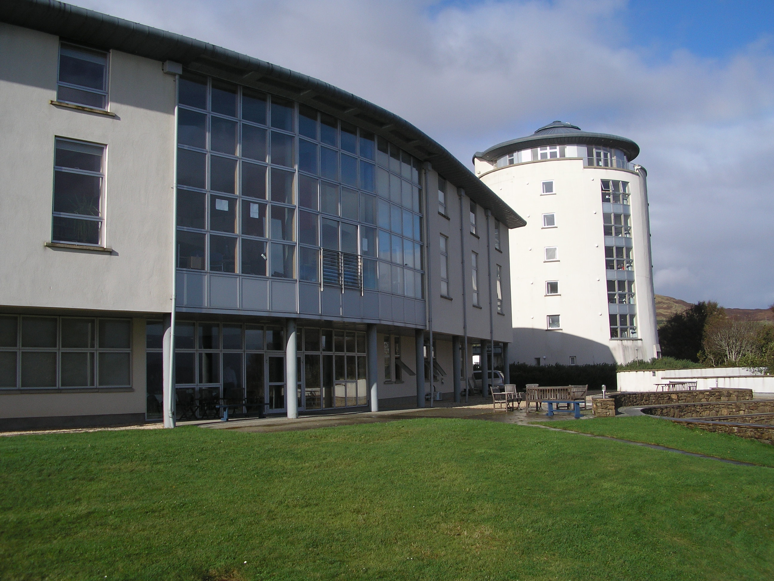
Students of Scottish Gaelic travel from all over the world to attend Sabhal Mòr Ostaig, the Scottish Gaelic college located near Kilmore in Sleat. In addition to members of the Church of Scotland and a smaller number of Roman Catholics, many residents of Skye belong to the Free Church of Scotland, known for its strict observance of the Sabbath.
Skye has a strong folk music tradition, although in recent years dance and rock music have been growing in popularity on the island. Gaelic folk rock band Runrig started in Skye and former singer Donnie Munro still works on the island. Runrig's second single and a concert staple is entitled Skye, the lyrics being partly in English and partly in Gaelic and they have released other songs such as "Nightfall on Marsco" that were inspired by the island. Celtic fusion band the Peatbog Faeries are based on Skye. Jethro Tull frontman Ian Anderson owned an estate at Strathaird on Skye at one time. Anderson wrote several songs for Jethro Tull about the island, including "Dun Ringil", "Broadford Bazaar", and "Acres Wild", the latter of which contains the lines "Come with me to the Winged Isle/Northern father's western child". The Isle of Skye Music Festival featured sets from The Fun Lovin' Criminals and Sparks, but collapsed in 2007. Electronic musician Mylo was born on Skye.

The poet Sorley MacLean, a native of the Isle of Raasay, which lies off the island's east coast, lived much of his life on Skye. The island has been immortalised in the traditional song "The Skye Boat Song" and is the notional setting for the novel To the Lighthouse by Virginia Woolf, although the Skye of the novel bears little relation to the real island. John Buchan's descriptions of Skye, as featured in his Richard Hannay novel Mr Standfast, are more true to life. I Diari di Rubha Hunis is a 2004 Italian language work of non-fiction by .
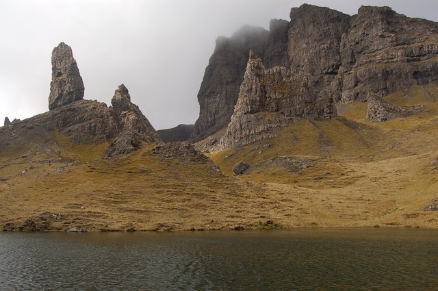
Skye has been used as a location for several feature films. The Ashaig aerodrome was used for the opening scenes of the 1980 film Flash Gordon. Another 2007 film, Seachd: The Inaccessible Pinnacle, was shot almost entirely in various locations on the island. The Justin Kurzel adaption of Macbeth starring Michael Fassbender was also filmed on the Island. Some of the opening scenes in Ridley Scott's 2012 feature film Prometheus were shot and set at the Old Man of Storr. In 1973 The Highlands and Islands - a Royal Tour, a documentary about Prince Charles's visit to the Highlands and Islands, directed by Oscar Marzaroli, was shot partly on Skye. Scenes from the Scottish Gaelic-language BBC Alba television series Bannan were filmed on the island.

The West Highland Free Press is published at Broadford. This weekly newspaper takes as its motto An Tìr, an Cànan 's na Daoine ("The Land, the Language, and the People"), which reflects its radical, campaigning priorities. The Free Press was founded in 1972 and circulates in Skye, Wester Ross, and the Outer Hebrides. Shinty is a popular sport played throughout the island and Portree-based Skye Camanachd won the Camanachd Cup in 1990. The local radio station Radio Skye is a community based station that broadcast local news and entertainment to the Isle Of Skye and Loch Alsh on 106.2 FM and 102.7 FM.

flagWhilst Skye had unofficial flags in the past, including the popular "Bratach nan Daoine" (Flag of the People) design which represented the Cuillins in sky blue against a white sky symbolising the Gaelic language, land struggle, and the fairy flag of Dunvegan, the Island received its first official flag "Bratach an Eilein" (The Skye Flag) approved by the Lord Lyon after a public vote in August 2020. The design by Calum Alasdair Munro reflects the Island's Gaelic heritage, the Viking heritage, and the history of Flora MacDonald. The flag has a birlinn in the canton, and there are five oars representing the five areas of Skye, Trotternish, Waternish, Duirinish, Minginish, and Sleat. Yellow represents the MacLeods, and Blue the MacDonalds or the MacKinnons.
Wildlife
The Hebrides generally lack the biodiversity of mainland Britain, but like most of the larger islands, Skye still has a wide variety of species. Observing the abundance of game birds Martin wrote:
Similarly, Samuel Johnson noted that:

In the modern era avian life includes the corncrake, red-throated diver, kittiwake, tystie, Atlantic puffin, goldeneye and golden eagle. The eggs of the last breeding pair of white-tailed sea eagle in the UK were taken by an egg collector on Skye in 1916 but the species has recently been re-introduced. The chough last bred on the island in 1900. Mountain hare (apparently absent in the 18th century) and rabbit are now abundant and preyed upon by wild cat and pine marten. The rich fresh water streams contain brown trout, Atlantic salmon and water shrew. Offshore the edible crab and edible oyster are also found, the latter especially in the Sound of Scalpay. There are nationally important horse mussel and brittlestar beds in the sea lochs and in 2012 a bed of 100 million flame shells was found during a survey of Loch Alsh. Grey Seals can be seen off the Southern coast.
Heather moor containing ling, bell heather, cross-leaved heath, bog myrtle and fescues is everywhere abundant. The high Black Cuillins weather too slowly to produce soil that sustains a rich plant life, but each of the main peninsulas has an individual flora. The basalt underpinnings of Trotternish produce a diversity of Arctic and alpine plants including alpine pearlwort and mossy cyphal. The low-lying fields of Waternish contain corn marigold and corn spurry. The sea cliffs of Duirinish boast mountain avens and fir clubmoss. Minginish produces fairy flax, cats-ear, and black bog rush. There is a fine example of Brachypodium-rich ash woodland at Tokavaig in Sleat incorporating silver birch, hazel, bird cherry, and hawthorn.
The local Biodiversity Action Plan recommends land management measures to control the spread of ragwort and bracken and identifies four non-native, invasive species as threatening native biodiversity: Japanese knotweed, rhododendron, New Zealand flatworm and mink. It also identifies problems of over-grazing resulting in the impoverishment of moorland and upland habitats and a loss of native woodland, caused by the large numbers of red deer and sheep.
In 2020 Clan MacLeod chief Hugh MacLeod announced a plan to reintroduce 370,000 native trees along with beaver and red squirrel populations to the clan estates on Skye, to restore a "wet desert" landscape which had depleted from years of overgrazing.

References
Pronunciation notes
Informational notes
Citations
Bibliography
- First published in 1947 under title: Natural history in the Highlands & Islands; by F. Fraser Darling.
- Gammeltoft, Peder "Scandinavian Naming-Systems in the Hebrides – A Way of Understanding how the Scandinavians were in Contact with Gaels and Picts?" in
- Jennings, Andrew, and Kruse, Arne, "One Coast – Three Peoples: Names and Ethnicity in the Scottish West during the Early Viking period" in
- {{cite book | author=McGoodwin, James R.|year=2001|location=Rome|title=Understanding the Cultures of Fishing Communities: A key to fisheries management and food security| series= Fisheries Technical Paper
- First printed for Andrew Bell and others, London.
References
- [[#Mur66. Murray (1966)]] p. 146.
- [[#HS04. Haswell-Smith (2004)]] p. 173.
- [[#HS04. Haswell-Smith (2004)]] pp. 502–03. Modified to include bridged islands.
- link. (5 June 2011 . [[Ordnance Survey]]. Retrieved 30 March 2008.)
- {{RESAS
- Infobox reference is [[#HS04. Haswell-Smith (2004)]] pp. 173–179 unless otherwise stated.
- "Isle of Skye". [[Ordnance Survey]].
- [http://www.argyll-yachtcharters.co.uk/Scottish%20Islands.pdf "Rick Livingstone's Tables of the Islands of Scotland"] {{Webarchive. link. (15 April 2023 . (pdf) Region 8. North West, North & East coasts. Argyll Yacht Charters. Retrieved 12 December 2011.)
- [[#Slesser70. Slesser (1981)]] p. 19.
- [[#Mur66. Murray (1966)]] pp. 147–48.
- [http://www.skye.co.uk/gaelic-culture.php "Gaelic Culture"] {{webarchive. link. (22 June 2006. [[VisitScotland]]. Retrieved 5 January 2013.)
- "Scotland's Island Populations". The Scottish Islands Federation.
- "Portree, Raasay & Central Skye". A Guide.
- [[#Mur66. Murray (1966)]] p. 155.
- [http://www.kmatthews.org.uk/Ravenna_Cosmography/group34.html "Group 34: islands in the Irish Sea and the Western Isles 1"] {{Webarchive. link. (8 May 2021 . Kmatthews.org.uk. Retrieved 1 March 2008.)
- Strang, Alistair (1997) "Explaining Ptolemy's Roman Britain". ''Britannia''. '''28''' pp. 1–30
- [[#HS04. Haswell-Smith (2004)]] pp. 173–79.
- {{Gaelic Placenames p. 105.
- [[#PG07. Gammeltoft, Peder (2007)]] p. 487.
- [[#JK09. Jennings and Kruse (2009)]] pp. 79–80.
- {{usurped
- [[s:Heimskringla/Magnus Barefoot's Saga#King Magnus Makes War on the Southern Hebudes. "Magnus Barefoot's Saga"]]. English translation: Wikisource. Retrieved 4 June 2008.
- {{lang. non. Skýey or {{lang. non. gd. An t-Eilean Sgitheanach (the island of Skye), {{lang. gd. An t-Eilean Sgiathanach being a more recent and less common spelling. In 1549, [[Donald Monro (priest). Donald Munro]], High Dean of the Isles, wrote of "Sky": "{{lang. sco. This Ile is callit {{lang. mga. Ellan Skiannach in Irish, that is to say in Inglish the wyngit Ile, be reason it has mony wyngis and pointis lyand furth fra it, throw the dividing of thir foirsaid Lochis."{{#tag:ref. English translation from [[Scots language. Lowland Scots]]: "This isle is called {{lang. mga. Ellan Skiannach in [[Scots Gaelic language. Gaelic]], that is to say in English, ''The Winged Isle'', because of its many wings and points that come from it, through dividing of the land by the aforesaid lochs."Munro, D. (1818). ''[[Description of the Western Isles of Scotland. Description of the Western Isles of Scotland called Hybrides, by Mr. Donald Munro, High Dean of the Isles, who travelled through most of them in the year 1549.]]'' Miscellanea Scotica, 2. Quoted in [[#Mur66. Murray (1966)]] p. 146.
- "Skye: A historical perspective". [[Gazetteer for Scotland]].
- {{#tag:ref. In April 2007 it was reported in the media that the island's official name had been changed by the [[Politics of the Highland council area. Highland Council]] to {{lang. gd. link. (3 June 2013 . Glasgow. ''[[The Herald (Glasgow)). The Herald]]''. Retrieved 28 December 2012.
- [[Martin Martin. Martin, Martin]] (1703) "A Description of The Isle of Skye". p. 65.
- The ascent of {{lang. gd. [[Sgùrr a' Ghreadaidh]] is one of the longest rock climbs in Britain and the [[Inaccessible Pinnacle]] is the only peak in Scotland that requires [[rock climbing. link. (22 August 2007 . skyewalk.co.uk. Retrieved 2 March 2008.)
- [[#SMC86. Bennet (1986)]] p. 222.
- Wells, Colin (2007) [http://www.heraldscotland.com/running-in-heaven-1.832035 "Running in Heaven"] {{Webarchive. link. (12 July 2015 . Glasgow. ''[[The Herald (Glasgow)). Sunday Herald]]''. Retrieved 28 December 2012.
- [[#SJ90. Johnstone ''et al.'' (1990)]] pp. 234–40.
- "The Kilt Rock, Skye". British Geological Survey.
- "Excursions".
- [[#Mur66. Murray (1966)]] p. 149.
- [[#Mur66. Murray (1966)]] pp. 156–61.
- {{usurped. gd. Comunn Eachdraidh Ealaghol agus Na Torran). Retrieved 9 March 2008.
- [[#Mur66. Murray (1966)]] pp. 147, 165.
- (September 1984). "First Jurassic dinosaur footprint from Scotland". Scottish Journal of Geology.
- (2020-03-11). "Novel track morphotypes from new tracksites indicate increased Middle Jurassic dinosaur diversity on the Isle of Skye, Scotland". PLOS ONE.
- Clark, Neil D. L.. (February 2018). "Review of the Dinosaur Remains from the Middle Jurassic of Scotland, UK". Geosciences.
- (2023-11-20). "A revision of the 'coelophysoid-grade' theropod specimen from the Lower Jurassic of the Isle of Skye (Scotland )". Scottish Journal of Geology.
- (May 2019). "New theropod dinosaur teeth from the Middle Jurassic of the Isle of Skye, Scotland". Scottish Journal of Geology.
- (November 2015). "Theropod dinosaurs from the Middle Jurassic (Bajocian–Bathonian) of Skye, Scotland". Scottish Journal of Geology.
- Clark, N. D. L.. (2005). "Tracking dinosaurs in Scotland". Open University Geological Society Journal.
- Liston, J. J.. (November 2004). "A re-examination of a Middle Jurassic sauropod limb bone from the Bathonian of the Isle of Skye". Scottish Journal of Geology.
- Barrett, Paul M.. (March 2006). "A sauropod dinosaur tooth from the Middle Jurassic of Skye, Scotland". Earth and Environmental Science Transactions of the Royal Society of Edinburgh.
- Clark, N. D. L.. (May 2001). "A thyreophoran dinosaur from the Early Bajocian (Middle Jurassic) of the Isle of Skye, Scotland". Scottish Journal of Geology.
- (April 2004). "Dinosaur footprints from the Duntulm Formation (Bathonian, Jurassic) of the Isle of Skye". Scottish Journal of Geology.
- "Staffin Museum".
- (12 January 2024). "Helping to safeguard Skye's fossil heritage FAQ's".
- [http://www.highland.gov.uk/yourcouncil/highlandfactsandfigures/highlandprofile.htm "Highland Profile"] {{webarchive. link. (4 May 2012. The Highland Council (2011 estimate). Retrieved 26 December 2012)
- (13 December 2018). "Exploring Scotland's majestic Isle of Skye, 13 December 2018".
- "Portree".
- [http://www.steininn.co.uk/ "Magical places do exist..."] {{Webarchive. link. (11 March 2011 . Steininn.co.uk. Retrieved 6 June 2010.)
- {{#tag:ref. Figures provided for Staffin, only a few miles to the east, average {{convert. 4.6. °C. °F in January and {{convert. 15.6. °C. °F in July at noon.[[#Slesser70. Slesser (1981)]] pp. 31–33. (20-year averages). See also [http://www.carbostweather.co.uk/Staffin/staffinweather.htm "Weather Data for Staffin Isle of Skye"] {{Webarchive. link. (14 November 2010 . Carbostweather.co.uk. Retrieved 7 June 2008.)
- [[#Mur66. Murray (1966)]] p. 147.
- Variations can be considerable, with the north tending to be drier than the south. Broadford, for example, averages more than {{convert. 2870. mm. in. Slesser (1981)]] pp. 27–31.
- [[#Mur73. Murray (1973)]] p. 79.
- Valor, G. Ballester. "Synop report summary".
- [[#COO. Cooper (1983)]] pp. 33–35. Averages for rainfall are for 1916–50, temperature 1931–60.
- (19 February 2024). "Portree last 24 hours weather". Met Office.
- "Records and Averages".
- (23 February 2021). "Climate Normals 1991–2020". Met Office.
- (23 February 2021). "Climate Normals 1991–2020". Met Office.
- Hardy, Karen. (July 2025). "At the far end of everything: A likely Ahrensburgian presence in the far north of the Isle of Skye, Scotland". Journal of Quaternary Science.
- Saville, Alan; Hardy, Karen; Miket, Roger; Ballin, Torben Bjarke [http://www.sair.org.uk/sair51/ "An Corran, Staffin, Skye: a Rockshelter with Mesolithic and Later Occupation"] {{webarchive. link. (29 September 2012. Scottish Archaeology Internet Reports. Retrieved 15 December 2012.)
- Wickham-Jones, C.R. and Hardy, K. [https://web.archive.org/web/20110724172318/http://www.historyscotland.com/features/firstsettlers.html "Scotlands First Settlers"]. History Scotland Magazine/[[Wayback Machine]]. Retrieved 15 December 2012.
- [http://www.umb.no/noragric/publications/workingpapers/noragric-wp-27.pdf ''Aesthetics, morality and bureaucracy: A case study of land reform and perceptions of landscape change in Northwest Scotland''] {{webarchive. link. (19 December 2008. (pdf) Centre for International Environment and Development Studies. Noragric. Aas. Retrieved 19 May 2008.)
- "Vol 12 (2004): Camas Daraich: a Mesolithic site at the Point of Sleat, Skye {{!}} Scottish Archaeological Internet Reports".
- [http://www.arcl.ed.ac.uk/arch/annrept/skyesurv.htm "Skye survey"] {{webarchive. link. (28 September 2011. University of Edinburgh. Retrieved 15 March 2008.)
- [http://canmore.rcahms.gov.uk/en/site/11028/details/skye+rubh+an+dunain+viking+canal "Skye, Rubh' An Dunain, 'Viking Canal'"] {{Webarchive. link. (22 October 2012 . Canmore. Retrieved 3 January 2013.)
- [[#HUN00. Hunter (2000)]] pp. 44, 49.
- [[#JK09. Jennings and Kruse (2009)]] p. 76.
- [[#JK09. Jennings and Kruse (2009)]] p. 77.
- [[#RS95. Sharpe (1995)]] Book I, chapter 26; Book II, chapter 33 & note 151.
- [[#JEF09. Fraser (2009)]] pp. 204–06, 249 & 252–53.
- [[#JK09. Jennings and Kruse (2009)]] p. 87.
- [http://www.celtictraditions.com/content/800x600/isle_of_skye/norse_connection.htm "The Norse Connection"] {{webarchive. link. (8 July 2011. Celtictraditions.com. Retrieved 15 March 2008.)
- Mackinnon, C.R.. (1958). "The Clan Mackinnon: a short history".
- [[#S3. Sellar (1999)]] pp. 3–4.
- [http://www.macinnes.org/info.php#about "About the Clan MacInnes"] {{Webarchive. link. (25 October 2016 . Macinnes.org. Retrieved 8 December 2010.)
- [[#Mur66. Murray (1966)]] p. 156.
- link. (19 January 2012 . Am Baile. Retrieved 24 October 2009.)
- [[#Boswell. Boswell (1785)]] pp. 142–43.
- [[#Mur66. Murray (1966)]] pp. 152–54.
- [[#HUN00. Hunter (2000)]] pp. 249–51.
- Johnson (1775) pp. 78–79.
- [http://www.dunvegancastle.com/content/default.asp "Dunvegan Castle"] {{webarchive. link. (2 August 2013. Dunvegancastle.com. Retrieved 2 March 2008.)
- [http://www.clandonald.com/index.php/page/castle/ "Armadale Castle"] {{webarchive. link. (4 August 2004. Clan Donald Centre. Retrieved 2 March 2008.)
- [[#MC08. Coventry (2008)]] pp. 381–82.
- {{usurped
- ]] In the late 18th century the harvesting of [[kelp]] became a significant activity,[[#COO. Cooper (1983)]] p. 77.
- [http://www.educationscotland.gov.uk/scotlandshistory/jacobitesenlightenmentclearances/kelpindustry/index.asp "The collapse of the kelp industry"] {{webarchive. link. (14 January 2013. [[Education Scotland]]. Retrieved 20 January 2013.)
- [https://www.bbc.co.uk/scotland/history/land_and_votes/skye_clearances/ "The Skye and Raasay Clearances – 1853"] . Video from ''A history of Scotland: This Land is Our Land''. BBC. Retrieved 26 December 2012.
- [https://web.archive.org/web/20080515073942/http://www.highlandclearances.info/clearances/clearances_battleofthebrae.htm "Battle of the Braes"]. Highlandclearances.info/[[Wayback Machine]]. Retrieved 15 December 2012.
- [[#HS04. Haswell-Smith (2004)]] p. 176.
- [https://www.trove.scot/place/11423 "Suisnish, Skye"]. Historic Environment Scotland. Retrieved 29 June 2025.
- [https://www.trove.scot/place/11032 "Skye, Tusdale"]. Historic Environment Scotland. Retrieved 29 June 2025.
- Allan, John [http://www.theskyeguide.com/about-skye-mainmenu-40 "The Skye Guide"] {{Webarchive. link. (7 January 2013 . The Skye Guide. Retrieved 26 December 2012.)
- {{NRS1C
- [[#Slesser70. Slesser (1981)]] p. 26.
- [[#HUN00. Hunter (2000)]] pp. 351–52.
- [[Sir Charles Cameron, 1st Baronet. Cameron, Charles]] (1886). ''The Skye expedition of 1886 its constitutional and legal aspects. Speech delivered by Charles Cameron at a meeting held in the City Hall, Glasgow, on the 10th November, 1886''. Glasgow. Alex. MacDonald.
- Arlidge, John (25 February 1996) "[https://www.independent.co.uk/news/uk/home-news/who-owns-scotland-1320933.html Who owns Scotland? Wealthy foreign owners of Scottish estates are facing a backlash from locals] {{Webarchive. link. (22 February 2015 ." London. ''The Independent''. Retrieved 2 January 2013.)
- See Boswell (1785) p. 141 at [https://archive.org/details/journaloftourtoh00boswiala Internet Archive]. (pdf) Retrieved 16 December 2012.
- [https://www.bbc.co.uk/news/uk-scotland-23711202 "Scotland's 2011 census: Island living on the rise"] {{Webarchive. link. (30 June 2016 . BBC News. Retrieved 18 August 2013.)
- Mac an Tàilleir, Iain (2004) {{usurped
- link. (18 January 2008. United Kingdom Parliament. Retrieved 8 March 2008.)
- [http://www.opsi.gov.uk/acts/acts1994/Ukpga_19940039_en_1.htm "Local Government etc. (Scotland) Act 1994: Chapter 39".] {{webarchive. link. (1 March 2010 [[Office of Public Sector Information]]. Retrieved 8 March 2008.)
- link. (30 August 2024 . The Highland Council. Retrieved 8 March 2008.)
- Ross, David (7 May 2011). "No Loyalty to LibDems in Highland Heartland". Election 2011 Supplement. Glasgow. ''[[The Herald (Glasgow). The Herald]]''.
- [http://www.visitscotland.com/info/see-do/the-aros-experience-p253331 "The Aros Experience"] {{Webarchive. link. (18 December 2012 . Visit Scotland. Retrieved 15 December 2012.)
- Wightman, Andy [http://www.whoownsscotland.org.uk/nav/in/index.html "Inverness"] {{Webarchive. link. (6 May 2021 . Who Owns Scotland. Retrieved 28 December 2012.)
- MacPhail, Issie (2002) [https://www.academia.edu/1330080/Land_crofting_and_the_Assynt_Crofters_Trust_A_post-colonial_geography ''Land, Crofting and The Assynt Crofters Trust: A Post-Colonial Geography?''] {{Webarchive. link. (14 August 2021 . [[University of Wales]]/Academia.edu. p. 174. Retrieved 28 December 2012.)
- [http://www.sleatcommunitytrust.co.uk/ "Welcome" page] {{Webarchive. link. (22 April 2012 . Sleat Community Trust. Retrieved 8 January 2013.)
- [http://www.dtascot.org.uk/content/directory-of-members "Directory of Members"] {{webarchive. link. (19 July 2010. Development Trusts Association Scotland. Retrieved 8 January 2013.)
- Macpherson, George W. [http://www.caledonia.org.uk/socialland/glendale.htm#Glendale%20Today "Glendale Today"] {{Webarchive. link. (25 February 2012 . Caledonia.org.uk. Retrieved 20 July 2009.)
- Jackson, Michael. (2017). "Whisky. The Definitive World Guide". Dorling Kindersley.
- [http://www.scotchwhisky.net/distilleries/talisker.htm "Talisker Scotch Whisky Distillery"] {{Webarchive. link. (14 August 2024 . Scotchwhisky.net. Retrieved 8 March 2008.)
- [http://www.gaelicwhisky.com/ "Pràban – The Home of fine Scottish Whisky"] {{Webarchive. link. (12 January 2008 . Gaelicwhisky.com. Retrieved 8 March 2008.)
- [http://www.pressport.co.uk/pressrelease/Record-year-for-Sitekit-9777.aspx "Sitekit reports a record year of growth"] {{webarchive. link. (30 December 2010. Pressport.co.uk. Retrieved 7 February 2011.)
- [http://www.skyemuseum.co.uk/cottages.html "The Croft House Kitchen"] {{webarchive. link. (9 January 2013. Skye Museum of Island Life. Retrieved 28 December 2012.)
- [https://www.thetimes.com/uk/scotland/article/crofters-angry-at-1m-grant-for-rewilding-project-on-skye-n2k86jgvs Crofters angry at £1m grant for rewilding project on Skye, 11 December 2020] .
- [[#HBP03. Highland Biodiversity Project (2003)]] p. 7.
- [http://www.skye.coop/skye_home.asp "Welcome"] {{webarchive. link. (31 December 2008. Isle of Skye Renewables Cooperative Ltd. Retrieved 31 March 2008.)
- Parker, David ''et al.'' (April 2008) "Leading by Example". Durham. ''New Sector''. Issue 78.
- [http://www.skye.co.uk/arts-crafts.php "Arts and Crafts"] {{webarchive. link. (10 October 2012. [[Visit Scotland]]. Retrieved 5 January 2013.)
- HIE Skye and Wester Ross (2008) "About our area". [[Highlands and Islands Enterprise]]. Inverness. Statistics are not produced for Skye alone, but for the Skye and Wester Ross area, in which the public sector provides 37.1 percent of the labour force.
- (18 September 2020). "Covid-19's £2.6bn hit to Highlands and Islands' economy".
- "Unemployment rate soars across Highlands and Islands, report finds".
- (15 December 2020). "Unemployment up by 116 per cent in Inverness since the start of Covid as Highland Council aims to launch a jobs programme amid fears those out of work could treble by next spring".
- (20 October 2020). "THE 20 MOST BEAUTIFUL VILLAGES IN THE UK AND IRELAND, 20 October 2020".
- (20 August 2024). "Visits to Skye's Storr could hit post-pandemic high". BBC News.
- (17 July 2020). "Year-long economic study finds Skye visitors boosted economy by £211 million pre-lockdown".
- (17 July 2020). "Tourists generated £211 million for Skye pre-pandemic, finds study, 17 July 2020".
- (1 September 2020). "The Impact of COVID-19 on the Highlands and Islands". HIE.
- Alison Campsie. (March 24, 2024). "Skye: Up to one million people destined for island amid calls for 'radical thinking' on tourism". The Scotsman.
- (26 August 2024). "The Storr – Update Report 24/25". Isle of Skye and Raasay Area Committee, Highland Council.
- Severin Carrell. (2017-08-09). "Skye islanders call for help with overcrowding after tourism surge".
- "On board the world's last surviving turntable ferry". BBC News.
- [http://www.notolls.org.uk/skat/skat.htm "SKAT: The Drive for Justice"] {{Webarchive. link. (13 May 2021 . Skye and Kyle Against Tolls. Retrieved 24 October 2009.)
- [http://www.isleofskye.net/travel/access/ "Getting Here"] {{Webarchive. link. (26 May 2024 . Isleofskye.net. Retrieved 24 October 2009.)
- [https://www.bbc.co.uk/news/uk-scotland-highlands-islands-18794536 "Potential use of Skye's Ashaig airstrip re-examined"] {{Webarchive. link. (12 November 2020 . [[BBC News Online]]. (11 July 2012) Retrieved 13 July 2012.)
- [http://www.smo.uhi.ac.uk/en/colaiste/index.php "Welcome to Sabhal Mòr Ostaig"] {{webarchive. link. (12 April 2013. UHI Millennium Institute. Retrieved 8 March 2008.)
- Pacione, Michael (2005) "The Geography of Religious Affiliation in Scotland". ''The Professional Geographer'' '''57 (2)''' pp. 235–255. Oxford. Blackwell.
- [http://www.donniemunro.co.uk/bio.htm "Donnie Munro: Biography"] {{webarchive. link. (30 May 2014. Donniemunro.co.uk. Retrieved 5 April 2007)
- link. (9 May 2010. Jimwillsher.co.uk. Retrieved 7 September 2009. The song also appears on the 1988 live ''[[Once in a Lifetime (Runrig album)). Once in a Lifetime]]'' album.
- link. (11 May 2010 Jimwillsher.co.uk. Retrieved 7 September 2009.)
- [http://www.peatbogfaeries.com/ "The Peatbog Faeries are ..."] {{Webarchive. link. (3 February 2005 . Peatbogfaeries.com. Retrieved 29 July 2011.)
- Gough, Jim (30 May 2004). [https://web.archive.org/web/20040607035038/http://www.sundayherald.com/42278 "Anderson swaps fish for his flute"]. Glasgow. ''[[The Herald (Glasgow). Sunday Herald]]''/[[Wayback Machine]]. Retrieved 28 December 2012.
- [http://www.cupofwonder.com/contents.html The Annotated Jethro Tull Lyrics Page] {{webarchive. link. (28 October 2007. Cupofwonder.com Retrieved 10 November 2007.)
- Chiesa, Alison (28 April 2008) [http://www.heraldscotland.com/skye-music-festival-pulled-as-administrators-are-called-in-1.878428 "Skye music festival pulled as administrators are called in"] {{Webarchive. link. (4 November 2013 . Glasgow. ''[[The Herald (Glasgow)). The Herald]]''. Retrieved 28 December 2012.
- [http://www.efestivals.co.uk/festivals/skye/2006/ "Isle of Skye Music Festival 2006"] {{Webarchive. link. (22 December 2017 . Efestivals.co.uk. Retrieved 8 March 2008.)
- [https://www.theguardian.com/music/mylo "Mylo – Biography"]. London. ''The Guardian''. Retrieved 15 December 2012.
- [http://www.bbc.co.uk/scotland/arts/writingscotland/writers/sorley_maclean/ "Sorley Maclean 1911–1996"] {{Webarchive. link. (15 January 2009 . BBC. Retrieved 8 March 2008.)
- [[#Westland97. Westland (1997)]] p. 90.
- [http://www.johnbuchansociety.co.uk/fiction/fms.htm ''Mr Standfast''] {{webarchive. link. (24 February 2012. John Buchan Society. Retrieved 17 March 2012.)
- ''[[Stardust (2007 film). Stardust]]'', released in 2007 and starring [[Robert De Niro]] and [[Michelle Pfeiffer]], featured scenes near Uig, [[Loch Coruisk]] and the [[Quiraing]].[https://www.rottentomatoes.com/m/stardust/ "Stardust"] {{Webarchive. link. (28 January 2017 . [[Rotten Tomatoes]]. Retrieved 12 January 2012.)
- [http://www.scotlandthemovie.com/movies/stardust1.html "Stardust – The Quiraing"] {{Webarchive. link. (18 May 2021 . Scotland the Movie. Retrieved 12 January 2012.)
- [http://www.scotlandthemovie.com/movies/fstar.html "Stardust (2007)"] {{Webarchive. link. (17 February 2019 . Scotland the Movie. Retrieved 12 January 2012.)
- link. (22 November 2023 . Seachd.com Retrieved 2 March 2008.)
- Aldona Reyes Mallet. (September 14, 2015). "Lights, Camera, Adventure! Filming Macbeth on Isle of Skye".
- [http://www.prometheusnews.net/movie/filming-location-roundup/ "Prometheus Filming Location Round-up"] {{webarchive. link. (14 June 2012. Prometheus News. Retrieved 4 July 2012.)
- link. (25 July 2011 . Scottish Screen Archive. Retrieved 21 June 2010.)
- [https://www.imdb.com/title/tt4396312/ Bannan TV series] {{Webarchive. link. (4 August 2021 IMDB.com)
- [https://www.bbc.co.uk/programmes/p0252lgf Bannan TV series] {{Webarchive. link. (28 August 2024 BBC Alba)
- [http://www.whfp.com/ ''West Highland Free Press''] {{Webarchive. link. (10 March 2007 . Broadford. Retrieved 2 March 2008.)
- "Club History". Skye Camanachd.
- "Radio Skye".
- (24 August 2020). "Skye unveils official flag for island". The Scotsman.
- For example, there are only half the number of mammalian species that exist on mainland Britain. See [[#Mur73. Murray (1973)]] p. 72.
- [[Martin Martin. Martin, Martin]] (1703). ''A Description of The Isle of Skye''. p. 72.
- [http://www.white-tailed-sea-eagle.co.uk/victorian-persecution.html "The Demise of the White-Tailed Eagle in Scotland"] {{webarchive. link. (23 December 2012. White-tailed-sea-eagle.co.uk. Retrieved 3 January 2012.)
- [[#FFD69. Fraser Darling (1969)]] p. 79.
- [http://www.duntulmcastle.co.uk/skye_wildlife.php "Trotternish Wildlife"] {{webarchive. link. (29 October 2013. Duntulm Castle. Retrieved 25 October 2009.)
- [[#FFD69. Fraser Darling (1969)]] pp. 71–72.
- [[#FFD69. Fraser Darling (1969)]] p. 286.
- [http://www.trout-salmon-fishing.com/scotland-skye.htm "Trout Fishing in Scotland: Skye"] {{Webarchive. link. (29 January 2018 . Trout-salmon-fishing.com. Retrieved 29 March 2008.)
- [[#FFD69. Fraser Darling (1969)]] p. 84.
- [http://www.snh.org.uk/pdfs/publications/wildlife/nativeoysters.pdf "Native Oysters"] {{webarchive. link. (29 October 2013. (pdf) (2005) [[Scottish Natural Heritage]]. Retrieved 29 December 2012.)
- [[#HBP03. Highland Biodiversity Project (2003)]] p. 6.
- [https://www.bbc.co.uk/news/uk-scotland-highlands-islands-20838775 "Marine Scotland survey uncovers 'huge' flame shell bed"] {{Webarchive. link. (9 May 2024 . [[BBC News Online]]. (27 December 2012) Retrieved 27 December 2012.)
- Slack, Alf "Flora" in [[#Slesser70. Slesser (1981)]] pp. 45–58.
- [[#FFD69. Fraser Darling (1969)]] p. 156.
- [[#HBP03. Highland Biodiversity Project (2003)]] pp. i, 3.
- Mike Merritt, [https://www.thetimes.com/uk/scotland/article/clan-chief-hugh-macleods-forest-will-rewild-skye-landscape-p0h7w8s3l ''Clan chief Hugh Macleod's forest will rewild Skye landscape''], The Times, 2 December 2020
This article was imported from Wikipedia and is available under the Creative Commons Attribution-ShareAlike 4.0 License. Content has been adapted to SurfDoc format. Original contributors can be found on the article history page.
Ask Mako anything about Isle of Skye — get instant answers, deeper analysis, and related topics.
Research with MakoFree with your Surf account
Create a free account to save articles, ask Mako questions, and organize your research.
Sign up freeThis content may have been generated or modified by AI. CloudSurf Software LLC is not responsible for the accuracy, completeness, or reliability of AI-generated content. Always verify important information from primary sources.
Report