From Surf Wiki (app.surf) — the open knowledge base
Isle of Pines (island)
Pacific island of New Caledonia
Pacific island of New Caledonia
| Field | Value |
|---|---|
| name | Isle of Pines |
| native_name | ** |
| sobriquet | l'île la plus proche du paradis |
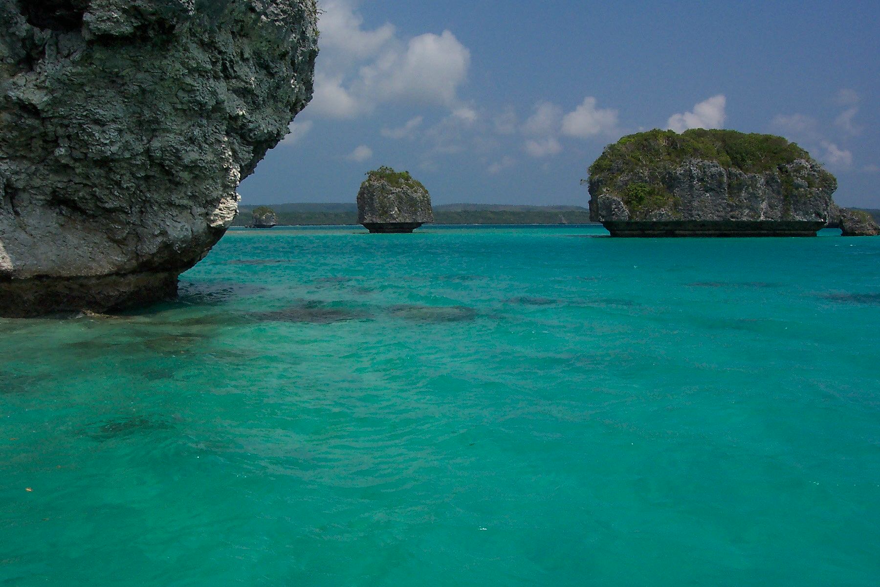
| image_name | Isle of Pines.jpg |
| image_size | 300px |
| image_caption | Ile Bayonnaise, Isle of Pines, New Caledonia |
| image_map | Ile-des-pins.PNG |
| map_caption | Location southeast of Grande Terre |
| archipelago | New Caledonia |
| area_km2 | |
| length_km | 15 |
| width_km | 13 |
| coastline_km | |
| elevation_m | 262 |
| highest_mount | pic Nga |
| country | France |
the island
The Isle of Pines (, ; , ) is an island in the Pacific Ocean, in the archipelago of New Caledonia, an overseas collectivity of France. The island is part of the commune (municipality) of L'Île-des-Pins, in the South Province of New Caledonia. The Isle of Pines is nicknamed l'île la plus proche du paradis ("the closest island to Paradise").
The island is around and measures 15 km by 13 km. It lies southeast of Grande Terre, New Caledonia's main island, and is 100 km southeast of the capital Nouméa. There is one airport (code ILP) with a 1,097 m runway. The Isle of Pines is surrounded by the New Caledonia Barrier Reef.
The inhabitants of the island are mainly native Melanesian Kanaks, and the population is 2,000 (estimated 2006) (1989 population 1,465).
The island is rich with animal life and is home to unusual creatures such as the crested gecko Correlophus ciliatus and the world's largest gecko, Rhacodactylus leachianus.
The pic Nga is the island's highest point, at 262 m elevation. River Ouro is the longest river.
History

Melanesian people lived on the island for over 2000 years before the island was first visited by Europeans. Captain James Cook in 1774 saw the island and renamed it on his second voyage to New Zealand. Cook gave the island its name after seeing the tall native pines (Araucaria columnaris). He never disembarked onto the island, but as he saw signs of inhabitance (smoke) assumed it was inhabited. In the 1840s, Protestant and Catholic missionaries arrived, along with merchants seeking sandalwood.
The French took possession of the island in 1853 at which time the native Kunies converted to the Catholic religion. In 1872, the island became a French penal colony, home to 3,000 political deportees from the Paris Commune.
Sights
The ruins of a penal colony can be seen in the village of Ouro in the west of the island. The water tower of Ouro which was built by prisoners in 1874/75 and renovated in 2005 is still used.
At the cemetery Cimetière des Déportés near Ouro is a pyramid-shaped memorial and the graves of 300 deportees who died between 1872 and 1880.
| File:IleDesPinsBagne.jpg | Ruins of the penal colony in Ouro | File:IleDesPinsChateau.jpg | Water tower in Ouro
Archaeology
Scattered across the central plateau of the island lie more than 300 poorly understood mounds, some of which have been excavated and found to have concrete cores. No human remains or man-made objects have been found in the mounds; one snail shell embedded in excavated concrete was carbon-dated to 12,900 ± 450 years old. Much as with the American mima mounds, there is no consensus on what these mounds are, and proposed explanations have included Paleolithic, Neolithic or later human construction, natural formations, or prehistoric birds’ nests, specifically of the extinct species Sylviornis neocaledoniae.
Notable people
- Guillaume Vama, Kanak insurrectionist and agroforestry entrepreneur
References
References
- [https://www.google.com/maps/place/Ile+Bayonnaise Google Maps location]
- "Passerelle transculturelle à l'usage des nouveaux personnels arrivant à Lifou au lycée des îles". [[Vice Rectorate of New Caledonia]].
- Chevalier, Luc. (1963). "Le problème des tumuli en Nouvelle-Calédonie". Société des Études mélanésiennes.
- Golson, Jack. (Winter 1961). "The Tumuli of New Caledonia (Report on New Zealand, Western Polynesia, New Caledonia, and Fiji)". University of Hawai'i Press.
- (1966). "Gif Natural Radiocarbon Measurements II". Radiocarbon.
- Shutler, R.. (1978). "Radiocarbon Dating and Oceanic Prehistory". Archaeology and Physical Anthropology in Oceania.
- Avias, Jacques. (1949). "Contribution a la prehistoire de L'Oceanie: les tumuli des Plateaux de Fer en Nouvelle-Caledonie". Journal de la Société des Océanistes.
- Golson, Jack. (1963). "Rapport sur les fouilles effectuees a l'ile des Pins (Nouvelle Caledonie) de Decembre 1959 li Fevrier 1960". Bulletin périodique de la Société des Études mélanésiennes.
- (1971). "Melanesia : a Geographical Interpretation of an Island World". London : Methuen.
- Frimigacci, Daniel: ”La prehistoire Neo-caledonienne”. Unpublished PhD thesis (thèse de doctorat), Universite de Paris, 1975
- Sand, Christophe. (1996). "Recent Developments in the Study of New Caledonia's Prehistory". Archaeology in Oceania.
- Green, Roger. (1989). "Those mysterious mounds are for the birds". New Zealand Archaeological Association.
- "Un projet d’agroforesterie sur terre coutumière". Les Nouvelles Calédoniennes.
This article was imported from Wikipedia and is available under the Creative Commons Attribution-ShareAlike 4.0 License. Content has been adapted to SurfDoc format. Original contributors can be found on the article history page.
Ask Mako anything about Isle of Pines (island) — get instant answers, deeper analysis, and related topics.
Research with MakoFree with your Surf account
Create a free account to save articles, ask Mako questions, and organize your research.
Sign up freeThis content may have been generated or modified by AI. CloudSurf Software LLC is not responsible for the accuracy, completeness, or reliability of AI-generated content. Always verify important information from primary sources.
Report