From Surf Wiki (app.surf) — the open knowledge base
Inverness, California

| Field | Value |
|---|---|
| official_name | Inverness |
| settlement_type | Unincorporated community |
| Census-designated place | |
| image_skyline | Inverness, California - March 2022 - Sarah Stierch.jpg |
| image_caption | Inverness in 2022 |
| image_map | Marin_County_California_Incorporated_and_Unincorporated_areas_Inverness_Highlighted.svg |
| mapsize | 250x200px |
| map_caption | Location in Marin County and the state of California |
| pushpin_map | USA |
| pushpin_map_caption | Location in the United States |
| coordinates | |
| subdivision_type | Country |
| subdivision_name | |
| subdivision_type1 | State |
| subdivision_name1 | California |
| subdivision_type2 | County |
| subdivision_name2 | Marin |
| leader_title | County Board |
| leader_name | District 4 |
| Dennis Rodoni | |
| leader_title1 | State senator |
| leader_name1 | |
| leader_title2 | Assemblymember |
| leader_name2 | |
| leader_title3 | U. S. rep. |
| leader_name3 | |
| unit_pref | US |
| area_footnotes | |
| area_total_sq_mi | 6.836 |
| area_land_sq_mi | 6.400 |
| area_water_sq_mi | 0.436 |
| area_water_percent | 6.38 |
| elevation_footnotes | |
| elevation_m | 13 |
| elevation_ft | 43 |
| population_footnotes | |
| population_total | 1379 |
| population_as_of | 2020 |
| population_density_sq_mi | 215.5 |
| timezone | PST |
| utc_offset | -8 |
| timezone_DST | PDT |
| utc_offset_DST | -7 |
| postal_code_type | ZIP code |
| postal_code | 94937 |
| area_code_type | Area codes |
| area_code | 415/628 |
| blank_name | FIPS code |
| blank_info | 06-36616 |
| blank1_name | GNIS feature ID |
| blank1_info | 1658827 |
Census-designated place Dennis Rodoni
Inverness is an unincorporated community in western Marin County, California, United States. It is located on the southwest shore of Tomales Bay 3.5 mi northwest of Point Reyes Station and about 40 mi by road northwest of San Francisco, at an elevation of 43 ft.
Community
Inverness is located on the west shore of Tomales Bay, which runs southeast along the line of the San Andreas Fault. Surrounded by Point Reyes National Seashore, it is primarily a residential community, with little industry other than tourism. It has a small downtown area with a general store, post office, library, two restaurants, one gift shop and a coffee shop. A third restaurant is located a short way north of downtown. There are also a number of hotels and inns spread throughout the town.
One aspect of the town is a concentration of recreational (and some commercial) boating. There is a small public marina, a few private piers, and the Inverness Yacht Club.
Portions of the John Carpenter film The Fog as well as most of his film Village of the Damned were shot in and around Inverness. In 1970, American singer and songwriter Jesse Colin Young moved his home and recording studio to Inverness. In 1993, Young and his wife Connie founded Ridgetop Music, a label based out of their home in Inverness.
History
The town is about 5 mi northeast of Drakes Bay on the Pacific Ocean, named after Sir Francis Drake, who explored the coast in the 16th century. Although Drake's official log was lost, the ship's doctor's log described landing in an area that reminded him of the White Cliffs of Dover. Drakes Bay is backed by similar-looking cliffs, leading many to believe this is where the ship landed.
The region became the property of James Shafter, who began to develop the property in the 1890s. It became a summer resort where people from San Francisco and Oakland came to camp, hike and swim in Tomales Bay. Many built small summer cabins that still exist today. Small steamboats took day trippers down the bay to secluded beaches. They left from Brock Schreiber's boathouse, which has been preserved and is a prominent local landmark with its prominent sign "Launch for Hire".
The first post office opened in 1897.
In 1995, Inverness Ridge was the site of the Mount Vision Fire, which burned a large area of Point Reyes National Seashore and a number of homes built on the ridge. The town itself was threatened but was saved by helicopters dipping water from Tomales Bay to drop on the Bishop pine forest between the town and the burning ridgetop.
Geography
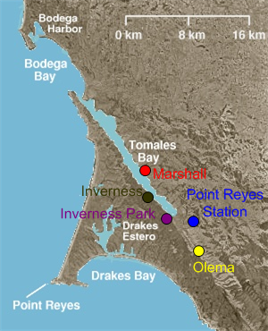
Inverness is located at . According to the United States Census Bureau, the CDP has a total area of 6.8 sqmi, of which 6.4 sqmi are land and 0.4 sqmi, or 6.38%, are water. The CDP includes the secondary community of Inverness Park, southeast of Inverness proper. It is bordered to the east by Point Reyes Station.
The town is adjacent to the San Andreas Fault and is spread out along approximately 2 mi of the western shore and valleys of Tomales Bay on the Point Reyes Peninsula. It provides services to visitors to the Point Reyes National Seashore and Tomales Bay State Park.
Climate
Inverness has a Mediterranean climate heavily influenced by the nearby Pacific Ocean, with cool, rainy winters and mild, dry summers. The community experiences a fairly narrow range of temperatures, due to its position only a few miles inland. The warmest month is actually September, a common pattern in the Bay Area due to the annual rollover in ocean currents.
|access-date=April 23, 2020
Demographics
|align-fn=center 1990 2000 2010
Inverness first appeared as a census designated place in the 1990 U.S. census.
The 2020 United States census reported that Inverness had a population of 1,379. The population density was 215.5 PD/sqmi. The racial makeup of Inverness was 1,191 (86.4%) White, 6 (0.4%) African American, 1 (0.1%) Native American, 23 (1.7%) Asian, 8 (0.6%) Pacific Islander, 34 (2.5%) from other races, and 116 (8.4%) from two or more races. Hispanic or Latino of any race were 94 persons (6.8%).
The whole population lived in households. There were 702 households, out of which 106 (15.1%) had children under the age of 18 living in them, 307 (43.7%) were married-couple households, 54 (7.7%) were cohabiting couple households, 208 (29.6%) had a female householder with no partner present, and 133 (18.9%) had a male householder with no partner present. 262 households (37.3%) were one person, and 146 (20.8%) were one person aged 65 or older. The average household size was 1.96.
The age distribution was 155 people (11.2%) under the age of 18, 50 people (3.6%) aged 18 to 24, 200 people (14.5%) aged 25 to 44, 379 people (27.5%) aged 45 to 64, and 595 people (43.1%) who were 65years of age or older. The median age was 61.1years. For every 100 females, there were 90.7 males.
There were 1,085 housing units at an average density of 169.5 /mi2, of which 702 (64.7%) were occupied. Of these, 456 (65.0%) were owner-occupied, and 246 (35.0%) were occupied by renters.
Education
Inverness is in the Shoreline Unified School District.
References
References
- "County of Marin District 4 webpage". [[County of Marin]].
- "Final Maps {{!}} California Citizens Redistricting Commission".
- {{Cite GovTrack. CA. 2
- "2021 U.S. Gazetteer Files: California". United States Census Bureau.
- {{gnis. 1658827
- "P1. Race – Inverness CDP, California: 2020 DEC Redistricting Data (PL 94-171)". U.S. Census Bureau.
- {{California's Geographic Names. 645
- (2018-04-16). "Marin history: How Inverness came to be".
- "Decennial Census by Decade".
- "1990 Census of Population - Population and Housing Unit Counts - California".
- "2000 Census of Population - Population and Housing Unit Counts - California".
- "2010 Census of Population - Population and Housing Unit Counts - California".
- "Inverness CDP, California; DP1: Profile of General Population and Housing Characteristics - 2020 Census of Population and Housing".
- "Inverness CDP, California; P16: Household Type - 2020 Census of Population and Housing".
- "2020 CENSUS - SCHOOL DISTRICT REFERENCE MAP: Marin County, CA". [[U.S. Census Bureau]].
This article was imported from Wikipedia and is available under the Creative Commons Attribution-ShareAlike 4.0 License. Content has been adapted to SurfDoc format. Original contributors can be found on the article history page.
Ask Mako anything about Inverness, California — get instant answers, deeper analysis, and related topics.
Research with MakoFree with your Surf account
Create a free account to save articles, ask Mako questions, and organize your research.
Sign up freeThis content may have been generated or modified by AI. CloudSurf Software LLC is not responsible for the accuracy, completeness, or reliability of AI-generated content. Always verify important information from primary sources.
Report