From Surf Wiki (app.surf) — the open knowledge base
Interstate 80 in Utah
Section of Interstate highway in Utah, United States

Section of Interstate highway in Utah, United States
| Field | Value | ||
|---|---|---|---|
| state | UT | ||
| type | I | ||
| route | 80 | ||
| alternate_name | Dwight D. Eisenhower Highway | ||
| Purple Heart Trail | |||
| section | 113 | ||
| map | |||
| map_custom | yes | ||
| map_notes | I-80 highlighted in red for Utah section | ||
| length_mi | 197.51 | ||
| length_ref | |||
| established | June 29, 1956 | ||
| history | Completed August 22, 1986 | ||
| tourist | |||
| [[File:Victory Highway Sign.svg | 25px | alt= | link=]] Victory Highway |
| direction_a | West | ||
| terminus_a | at Nevada state line | ||
| junction | near Magna | ||
| in Salt Lake City | |||
| in Salt Lake City | |||
| in Salt Lake City | |||
| in Salt Lake City | |||
| in South Salt Lake | |||
| in South Salt Lake | |||
| in Millcreek | |||
| near Park City | |||
| in Echo | |||
| direction_b | East | ||
| terminus_b | at Wyoming state line | ||
| counties | Tooele, Salt Lake, Summit | ||
| previous_type | SR | ||
| previous_route | 79 | ||
| next_type | SR | ||
| next_route | 81 |
Purple Heart Trail in Salt Lake City in Salt Lake City in Salt Lake City in Salt Lake City in South Salt Lake in South Salt Lake in Millcreek near Park City in Echo Interstate 80 (I-80) is a part of the Interstate Highway System that runs from San Francisco, California, to Teaneck, New Jersey. The portion of the highway in the US state of Utah is 197.51 mi long through the northern part of the state. From west to east, I-80 crosses the state line from Nevada in Tooele County and traverses the Bonneville Salt Flats—which are a part of the larger Great Salt Lake Desert. It continues alongside the Wendover Cut-off—the corridor of the former Victory Highway—US Route 40 (US-40) and the Western Pacific Railroad Feather River Route. After passing the Oquirrh Mountains, I-80 enters the Salt Lake Valley and Salt Lake County. A short portion of the freeway is concurrent with I-15 through Downtown Salt Lake City. At the Spaghetti Bowl, I-80 turns east again into the mouth of Parleys Canyon and Summit County, travels through the mountain range, and intersects the eastern end of I-84 near Echo Reservoir before turning northeast toward the Wyoming border near Evanston. I-80 was built along the corridor of the Lincoln Highway and the Mormon Trail through the Wasatch Range. The easternmost section also follows the historical routes of the first transcontinental railroad and US-30S.
Construction of the controlled-access highway began in the 1950s, and, by the late 1970s, most of the freeway across the state of Utah had been completed. The 4.5 mi section of I-80 between State Route 68 (SR-68, Redwood Road) and Salt Lake City International Airport was the last piece of the nearly 2900 mi freeway to be completed. It was opened on August 22, 1986, and was about 50 mi from the site of another cross-country milestone in Utah, the driving of the golden spike of the first transcontinental railroad at Promontory Summit. Average daily traffic volumes in 2012 ranged between 6,765 vehicles using the freeway at SR-58 and 121,205 vehicles using the freeway at the Spaghetti Bowl in Downtown Salt Lake City. Throughout the state, the highway is also known as the Purple Heart Trail.
Route description
Out of the 11 states which I-80 passes through, the 197.51 mi segment in Utah is the fourth shortest. As part of the Interstate Highway System, the entire route is listed on the National Highway System, a system of roads that are important to the nation's economy, defense, and mobility.
Every year, the Utah Department of Transportation (UDOT) conducts a series of surveys on its highways to measure traffic volumes. This measure is expressed in terms of annual average daily traffic (AADT), a measure of traffic volume for any average day of the year. In 2012, UDOT calculated that as few as 6,765 vehicles traveled I-80 at the interchange with SR-58 in Wendover, and as many as 121,205 vehicles used the highway at the Spaghetti Bowl in Downtown Salt Lake City. Between 7 and 58 percent of the traffic recorded consisted of trucks. These counts are for the portion of the freeway in Utah.
Tooele County
The freeway enters Utah from Nevada in the city of Wendover on the edge of the Bonneville Salt Flats. The cities of West Wendover, Nevada, and Wendover are accessible by I-80's only business loop in Utah, whose interchange is just south of Danger Cave. The highway closely follows the historical routes of the Wendover Cut-off, Victory Highway, and formerly Western Pacific Railroad's Feather River Route (now part of the Union Pacific Railroad Central Corridor) across the salt flats and the larger Great Salt Lake Desert. Bonneville Speedway, home to many land speed records, is accessible from I-80. In the middle of the salt flats is a concrete sculpture, Metaphor: The Tree of Utah, which stands just off the westbound carriageway of I-80, 30 mi east of Wendover.
Bounded on each sides by military training grounds, the I-80 corridor is overflown by commercial airliners traveling west from Salt Lake City International Airport. The freeway veers north around the Cedar Mountains in a small gap between them and the Lakeside Mountains. Further east, the highway passes the Stansbury Mountains, which are located in the Wasatch–Cache National Forest. After the mountain ranges, the freeway arrives at the southern shore of the Great Salt Lake and closely follows the shore toward the western suburbs of Salt Lake City. However, the historical routes from which the route of I-80 was derived were routed further from the lake, passing through the towns of Grantsville and Tooele; these communities are now served by SR-138 and SR-36, respectively. It is in this section that I-80 reaches its lowest elevation in Utah, 4203 ft above sea level. After an interchange with SR-36 at Lake Point, the highway crosses a bottleneck between the Oquirrh Mountains and the Great Salt Lake.
Salt Lake County
While traversing the neck, views can be had from I-80 of the lake and Antelope Island. After passing the neck, the road forks, with I-80 proceeding toward the north end of Salt Lake City and SR-201 proceeding toward the south end. Historically, this intersection was the separation of US-40 and US-50. After the intersection, the freeway corridor is again bottlenecked with the Great Salt Lake to the north and the Kennecott Utah Copper smelter and tailings pond to the south. The Kennecott Utah Copper's Bingham Canyon Mine, which was once considered to be the largest open-pit copper mine, can be seen in the distance. The 1215 ft Kennecott Garfield Smelter Stack is one of the tallest freestanding structures in the United States. Along this portion, the freeway passes the historical site of Saltair.
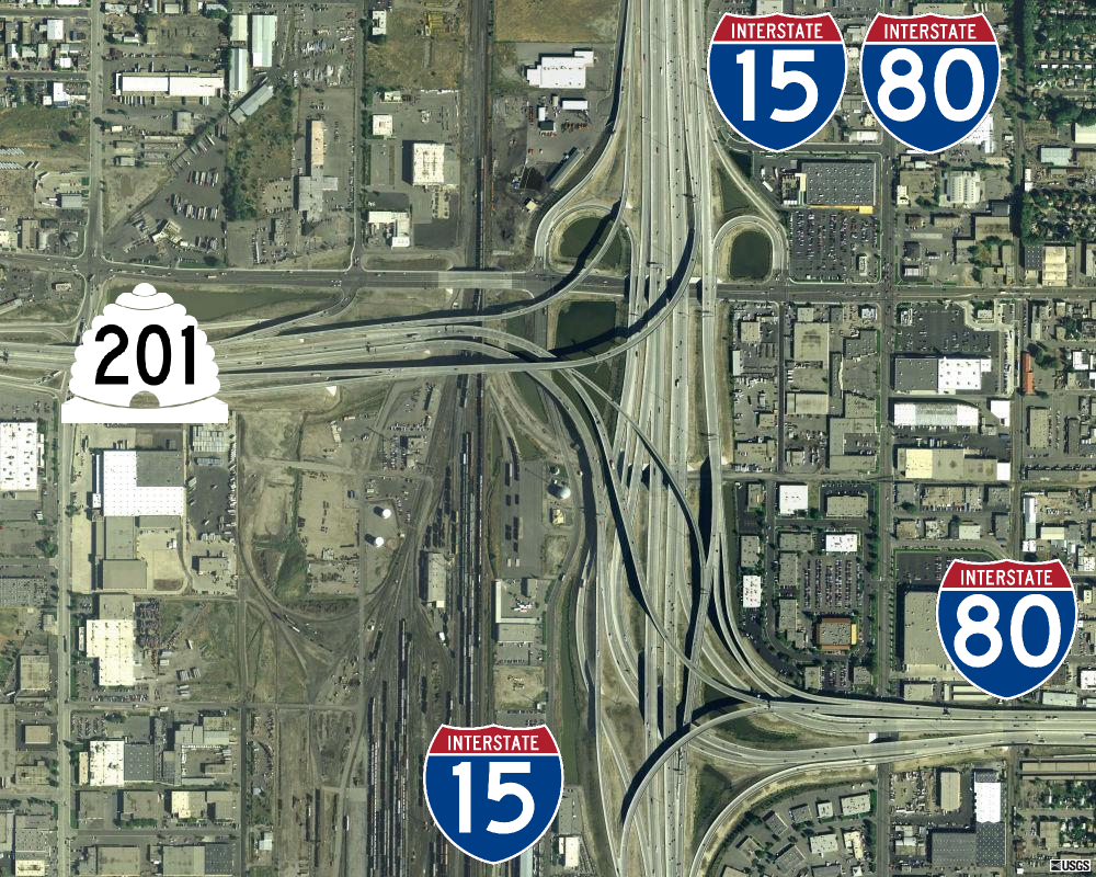
The freeway enters the Salt Lake Valley on the former alignment of North Temple Street until it passes Salt Lake City International Airport, where the freeway veers slightly south and leaves the North Temple Street corridor which leads to Temple Square in Downtown Salt Lake City. The Green Line of the Utah Transit Authority (UTA) TRAX system briefly parallels I-80 before traveling down the center of North Temple Street. I-80 becomes concurrent with I-15 after interchanges with SR-68 and 600 South and continues south for about 3 mi, passing along the western and southern edges of Downtown Salt Lake City. The southern interchange with I-15, which also includes SR-201 (21st South Freeway) and marks the end of the concurrency, is known as the Spaghetti Bowl. In the southwestern corner of the Spaghetti Bowl is another portion of the UTA TRAX Green Line as it travels towards West Valley City. After separating from I-15, the freeway continues easterly through South Salt Lake, loosely following an alignment just south of 2100 South and the UTA S Line streetcar through the Sugar House neighborhood and past Sugar House Park—once the home of the Sugar House Prison—toward the clockwise terminus of the I-215 270-degree beltway around Salt Lake City. It continues through Parleys Canyon, where the freeway joins the historical route of the Lincoln Highway. Between the mouth of the canyon and the Summit County line, the route reenters the Wasatch National Forest.
Summit County
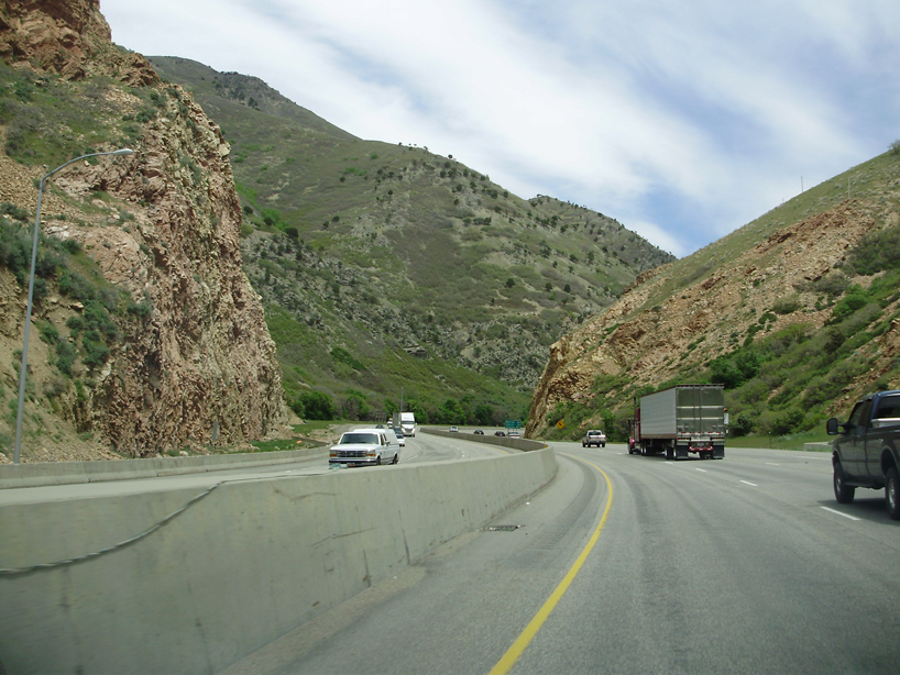
Parleys Canyon carries I-80 up the eastern slope of the Wasatch Front as a six-lane freeway, cresting the mountains at an elevation of 7016 ft at Parleys Summit, the highest point on I-80 within the state of Utah. Both the canyon and summit were named for Parley P. Pratt, an early settler to the Salt Lake Valley and an early Mormon leader who was asked to survey a new route across the mountains to replace the route through Emigration Canyon. Between 1848 and 1851, Pratt surveyed, completed, and operated the Golden Pass toll road through the canyon that today bears his name. Pratt had unsuccessfully solicited for $800 (equivalent to $ in ) to build the road and sold it for $1,500 (equivalent to $ in ). On- and offramps for the Wyoming port-of-entry are located just within Utah. In January 2014, UDOT introduced variable speed limits to I-80 in Parleys Canyon, allowing a speed limit between 35 mph up to the normal 65 mph depending on weather or traffic conditions.
Beyond Parleys Summit lies Park City, a mining town today better known for its many ski resorts. The Historic Union Pacific Rail Trail State Park travels in the median between carriageways of I-80 before paralleling the highway until the southern end of Echo Reservoir. The freeway turns north upon reaching the Rockport Reservoir at Wanship following the tributaries of the Weber River toward Echo Reservoir and Dam. Upon reaching Echo Canyon and the junction with the eastern terminus of the western section of I-84, the freeway follows the canyon east until it reaches the Wyoming state line near Evanston. I-80 forms the northeastern border between Rich and Summit counties.
The portion through Echo Canyon follows the historical routes of the Mormon Trail, US-30S, and the first transcontinental railroad. A rest area in the canyon just east of the junction with I-84 features signs pointing out features that were obstacles for both the Mormon pioneers and the railroad construction workers, including Pulpit Rock, which was partially demolished when the I-80 was built through the canyon.
History

Earlier roads
I-80 follows the routes of two major auto trails through the state. In western Utah, I-80 follows the historical route of the Victory Highway from Wendover at the Nevada state line to the junction of US-40 near Park City. Throughout Utah, I-80 is signed as the modern route of the Lincoln Highway—except through Salt Lake City, where the Lincoln Highway is routed along SR-201 and Parley's Way. The route of the Lincoln Highway across Utah was generally derived from the route of the Pony Express and Central Overland Route. However, much of the original route of the Lincoln Highway west of Salt Lake City is inaccessible. The original route of the Lincoln Highway proceeded southwest from Tooele toward Ely, Nevada. This area is now used for military bases, such as the Dugway Proving Ground and Tooele Army Depot. The area was closed to the public when these bases were established. I-80 and US-93 are the modern signing of the Lincoln Highway between those two cities. East of Salt Lake City, I-80 closely parallels the original route of the Lincoln Highway.
In 1926, much of the route covered by I-80, including Pratt's former toll road from the Nevada state line into Salt Lake City, was signed as US-40 then as US-30 to the Wyoming state line. It was also part of the Victory Highway west of Salt Lake and the Lincoln Highway east of Salt Lake at this time. Most of the route had been improved but some stretches of graded road remained. In 1937, parts of the route near Wanship were numbered US-530. In 1950, the highway near Echo was designated US-30S and US-189. By 1959, US-50 Alternate (US-50 Alt) was also routed along the western portion of I-80.
Current road
The first Utah state route to have the number 80 is now known as SR-92, which was originally numbered SR-80 until the 1977 Utah state route renumbering. Previously, the freeway's legislative designation was SR-2.

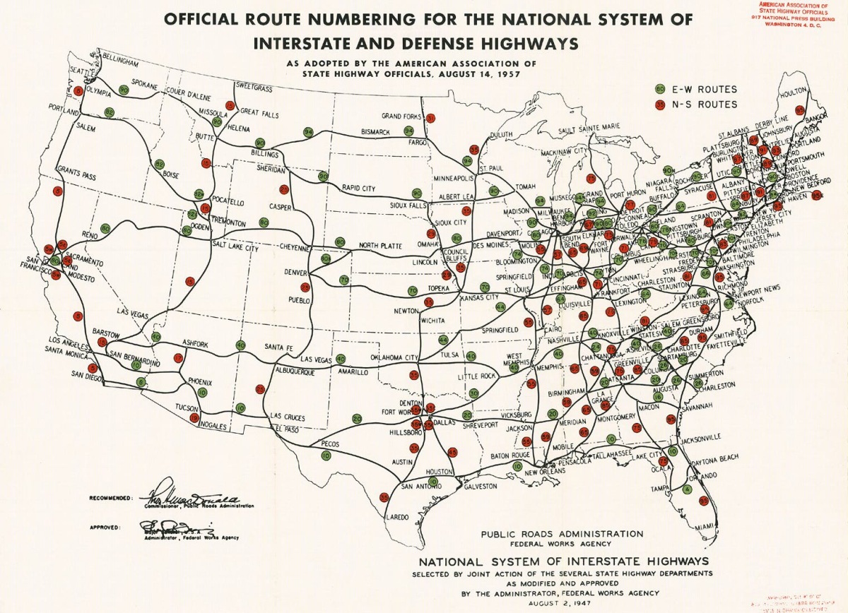
Passage of the Federal-Aid Highway Act of 1956 formed the Interstate Highway System, and the I-80 number was first designated to a then-unconstructed controlled-access highway across the state by 1957. I-80 was constructed in segments, starting in the late 1950s. By the late 1970s, the Utah portion of I-80—except for a gap on the western edge of Salt Lake City—was largely complete. A 4.5 mi section between Redwood Road and Salt Lake City International Airport is the final link of the transcontinental freeway to be completed. As an Interstate Highway, design specifications require a controlled-access highway with no at-grade intersections. This section was dedicated on August 22, 1986, and was the last to be completed to Interstate Highway specifications along the almost 2900 mi route of I-80 between San Francisco, California, and Teaneck, New Jersey. The section was completed close to the 30th anniversary of the Interstate Highway System, which was noted at the dedication and considered to be a milestone in the history of highway construction in the United States. It was also noted at the dedication that this was only 50 mi south of Promontory Summit, where the golden spike of the US's first transcontinental railroad was laid.

The original designation of I-84, which begins at an interchange with I-80 in Echo, was I-80N. This designation was changed to I-84 in 1977 by the American Association of State Highway and Transportation Officials (AASHTO) despite objections from the Washington State Department of Transportation (WSDOT) and the Idaho Transportation Department (ITD) and with the support of UDOT and the Oregon Department of Transportation (ODOT). The legislative designation for this highway was SR-3 until the 1977 renumbering.
Rebuilding of the first portions of I-80 began in October 1990 with a 1.4 mi stretch near Redwood Road in Salt Lake City. By 1991, UDOT estimated that the reconstruction of all federally funded highways in the state would cost up to $4.3 billion (equivalent to $ in ).
Plans for the Spaghetti Bowl were announced in 1996. It was needed to accommodate traffic for the 2002 Winter Olympics being held in the city. Most of the Spaghetti Bowl was open by November 2000; the remainder opened in early 2001.
In 2002, the Utah State Legislature named the highway the Purple Heart trail, in honor of wounded war veterans.
Additional reconstruction work—which involved the replacement of most of the bridges along the route and the resurfacing and installation of sound barriers—was done on I-80 between the Spaghetti Bowl and Parleys Canyon from 2007 to 2008.
Exit list
Salt Lake City International Airport
Notes
References
References
- (December 31, 2021). "Table 1: Main Routes of the Dwight D. Eisenhower National System Of Interstate and Defense Highways". [[Federal Highway Administration]].
- Slater, Rodney E.. (Spring 1996). "The National Highway System: A Commitment to America's Future". Public Roads.
- Federal Highway Administration. (November 18, 2013). "National Highway System: Utah". Federal Highway Administration.
- Staff. (2012). "Traffic on Utah Highways". [[Utah Department of Transportation]].
- Utah Department of Transportation. (2012). "Truck Traffic on Utah Highways". Utah Department of Transportation.
- Utah Department of Transportation. (2005). "General Highway Map". Utah Department of Transportation.
- {{google maps. link
- Tooele County. "Danger Cave". Tooele County.
- California-Oregon-Washington Tourist Association. (1927). "Copyrighted Official Map". California-Oregon-Washington Tourist Association.
- Benchmark Maps. (2002). "Utah Road and Recreation Atlas". Benchmark Maps.
- Radbruch, Don. (January 2004). "Dirt Track Auto Racing: 1919-1941 - A Pictorial History". [[McFarland & Company]].
- Griggs, Brandon. (September 2023). "Utah Curiosities: Quirky Characters, Roadside Oddities & Other Offbeat Stuff". Morris Book Publishing, LLC.
- Utah Department of Transportation. (2005). "General Highway Map". Utah Department of Transportation.
- (October 17, 2013). "Salt Lake City — South". Federal Aviation Administration.
- Utah Department of Transportation. (2005). "General Highway Map". Utah Department of Transportation.
- Utah Department of Transportation. (2005). "General Highway Map". Utah Department of Transportation.
- "Google Maps Elevation API calls".
- Utah Department of Transportation. (2005). "General Highway Map". Utah Department of Transportation.
- Hamblin, W. Kenneth. (1992). "Roadside Geology of U.S. Interstate 80 Between Salt Lake City and San Francisco". [[American Geological Institute]].
- Arave, Lynn. (November 16, 2009). "Holy smokes: Kennecott smelter, Utah's tallest man-made structure, to turn 35". [[Deseret News]].
- (October 3, 2003). "Motorists Should Avoid Spaghetti Bowl this Weekend". [[KSL-TV]].
- Arave, Lynn. (July 14, 2006). "Prison once stood where park now is". Deseret News.
- Lincoln Highway Association. (1923). "Map of Strategic Routes between Salt Lake City, Utah and California". Lincoln Highway Association.
- Utah Department of Transportation. (2011). "Official Highway Map". Utah Department of Transportation.
- "Church History: Golden Pass Road". [[Intellectual Reserve]].
- Davidson, Lee. (January 7, 2014). "UDOT launches variable speed limit system on I-80 in Parleys Canyon". [[The Salt Lake Tribune]].
- Balaz, Christine. (June 2, 2009). "An Explorer's Guide: Utah". [[Countryman Press]].
- Wilson, Arnie. (2007). "Ski Atlas of the World". [[New Holland Publishers]].
- Utah Department of Natural Resources. "Historic Union Pacific Rail Trail". Utah Department of Natural Resources.
- Utah Department of Transportation. (2005). "General Highway Map". Utah Department of Transportation.
- Utah Department of Transportation. (2005). "General Highway Map". Utah Department of Transportation.
- (1945). "Utah: A Guide to the State". Somerset Publishers.
- (1916). "Part B. The Overland route: With a Side Trip to Yellowstone Park". [[United States Government Printing Office]].
- Crain, Jim. (September 1, 1994). "California in Depth: A Stereoscopic History". [[Chronicle Books]].
- Patrick, Kevin J.. "Lincoln Highway Resource Guide". [[Indiana University of Pennsylvania]].
- Hokanson, Drake. (1999). "Lincoln Highway – Main Street Across America". [[University of Iowa Press]].
- (March 2010). "Parley's Canyon Trail: Feasibility Assessment Report". Salt Lake County.
- (November 11, 1926). "United States System of Highways Adopted for Uniform Marking by the American Association of State Highway Officials". [[U.S. Geological Survey]].
- Rand McNally. (1926). "Rand McNally Junior Road Map". Rand McNally.
- Texaco. (1937). "Texaco Road Map Idaho, Montana, Wyoming". Rand McNally.
- Shell Oil Company. "Highway Map of Utah". H.M. Gousha Company.
- United States Geological Survey. (1958). "State of Utah". United States Geological Survey.
- Utah Department of Transportation. (November 2008). "Route 80". Utah Department of Transportation.
- Lewis, Tom. (1997). "Divided Highways: Building the Interstate Highways, Transforming American Life". Viking.
- Public Roads Administration. (August 14, 1957). "Official Route Numbering for the National System of Interstate and Defense Highways as Adopted by the American Association of State Highway Officials". Public Roads Administration.
- (October 18, 2010). "The First Book of Seconds". [[Adams Media]].
- (Fall 1986). "America Celebrates 30th Anniversary of the Interstate System". Federal Highway Administration.
- (August 25, 1986). "Around the Nation: Transcontinental Road Completed in Utah". The New York Times.
- (October 2, 1990). "Rebuilt I-80 Section, Redwood to I-15, Opens on Schedule". The Salt Lake Tribune.
- Jonsson, Dave. (May 16, 1991). "Roads Need $4.3 Billion in Next 20 Years". The Salt Lake Tribune.
- Baltezore, Jay. (March 21, 1996). "UDOT Says I-15 Can Be Redone by 2001 UDOT: I-15 Can Be Redone by 2001". The Salt Lake Tribune.
- (November 2, 2000). "Most Interstate 15 Freeway Ramps Around 2100 South Are Open". The Salt Lake Tribune.
- (2002). "72-4-207: The Purple Heart Trail". [[Utah State Legislature]].
- House, Dawn. (August 2, 2004). "Purple Heart monument to be dedicated at HAFB". The Salt Lake Tribune.
- (July 31, 2008). "I-80 bridge replacement complete; State Street reopened". KSL-TV.
- Utah Department of Transportation. (February 8, 2010). "Route 80". Utah Department of Transportation.
- Utah Department of Transportation. (December 17, 2012). "Route 15". Utah Department of Transportation.
- Sutton, Ceilly. (December 30, 2021). "Top News 2021 #1: UDOT finally opens Midvalley Highway". Tooele Transcript Bulletin.
- Utah State Parks, [https://stateparks.utah.gov/parks/great-salt-lake/directions/ Directions], accessed 10 February 2022
This article was imported from Wikipedia and is available under the Creative Commons Attribution-ShareAlike 4.0 License. Content has been adapted to SurfDoc format. Original contributors can be found on the article history page.
Ask Mako anything about Interstate 80 in Utah — get instant answers, deeper analysis, and related topics.
Research with MakoFree with your Surf account
Create a free account to save articles, ask Mako questions, and organize your research.
Sign up freeThis content may have been generated or modified by AI. CloudSurf Software LLC is not responsible for the accuracy, completeness, or reliability of AI-generated content. Always verify important information from primary sources.
Report