From Surf Wiki (app.surf) — the open knowledge base
Inn (river)
River in Switzerland, Austria and Germany
River in Switzerland, Austria and Germany
| Field | Value |
|---|---|
| name | Inn |
| name_other | |
| image | UnterinntalWest.JPG |
| image_caption | Lower Inn valley from Rattenberg castle |
| mapframe | yes |
| mapframe-zoom | 6 |
| source1_location | Swiss Alps (Lägh dal Lunghin) |
| source1_elevation | 2484 m |
| source1_coordinates | |
| mouth_location | Danube (Passau) |
| mouth_elevation | 291 m |
| mouth_coordinates | |
| progression | |
| subdivision_type1 | Countries |
| subdivision_name1 | |
| subdivision_type2 | Cities |
| subdivision_name2 | |
| length_km | 518.5 |
| length_ref | |
| discharge1_location | mouth |
| discharge1_avg | 735 m3/s |
| basin_size_km2 | 26053 |
| basin_size_ref |
|mapframe-zoom = 6
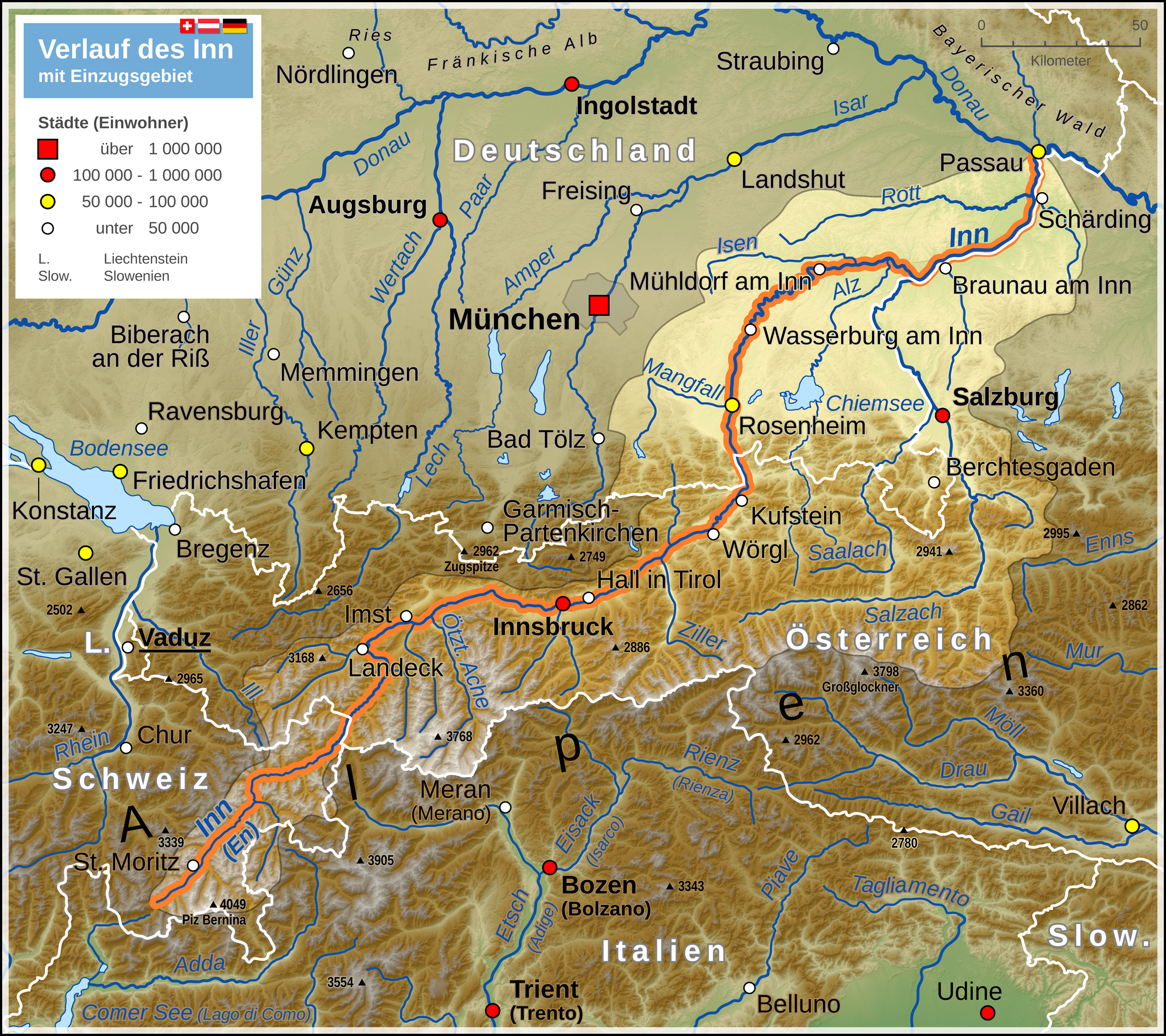
The Inn (; ; ) is a river in Switzerland, Austria and Germany. The 518 km long river is a right tributary of the Danube, being the third largest tributary of the Danube by discharge. The highest point of its drainage basin is the summit of Piz Bernina at 4049 m. The Engadine, the valley of the En, is the only Swiss valley whose waters end up in the Black Sea (via the Danube).
Etymology
The name Inn is derived from the old Celtic words en and enios, meaning water. In a document of 1338, the river was named Wasser (German for water). The first written mention from the years 105 to 109 (Publii Corneli Taciti historiarium liber tertius) reads: "... Sextilius Felix... ad occupandam ripam Aeni fluminis, quod Raetos Noricosque interfluit, missus..." ("... Sextilius Felix was sent to capture the banks of the Inn, which flows between the Rhaetian people and the Noric people.") The river is also mentioned by other authors of the Roman Empire as Ainos (Greek) or Aenus (Latin). In medieval Latin it was written as Enus or Oenus. The change in the old Bavarian language from e to i turned Enus to In. Until the 17th century, it was written In or Yn, but also Ihn or Yhn. The double-n appeared only in the 16th century, for example in the Tyrolian Landreim of 1557, and since the 18th century this spelling and pronunciation with a short vowel has been customary.
The mentions in Roman times refer to the lower course. The Tyrolean section was first called Aenus by Venantius Fortunatus in the 6th century. The name Engadin and the Romansh name En indicate that the upper reaches of the river have long been called this way. Even though it was occasionally believed that the Inn originated near the Adige at the Reschen Pass, since the 16th century at the latest the origin has been seen uniformly in the area of the lakes at the Maloja Pass.
A connection may exist between the name Inn and the name of the French river Ain.
Geography
The source of the Inn is located in the Swiss Alps, west of St. Moritz in the Engadine region, which is named after the river (Romansh Engiadina; Latin vallis Eniatina). Shortly after it leaves its source, the Inn flows through the largest lakes on its course, Lake Sils and Lake Silvaplana. It runs north-eastwards, entering Austria, and from Landeck eastwards through the Austrian state of Tyrol and its capital, Innsbruck (bridge over the Inn), and crosses the border into Bavaria near Kufstein.
On Bavarian territory the river runs northwards and passes Rosenheim, Wasserburg am Inn, and Waldkraiburg; then it turns east, runs through Mühldorf and Neuötting and is enlarged by two major tributaries, the Alz and the Salzach. From here to the Danube, it forms the border between Germany (Bavaria) and Austria (Upper Austria). Towns on this last section of the river are Marktl am Inn, Simbach on Inn, Braunau am Inn and Schärding.
In Passau the Inn finally enters the Danube (as does the river Ilz there). Although the Inn has a greater average flow than the Danube when they converge in Passau, and its watershed contains the Piz Bernina, the highest point in the Danube watershed, the Inn is considered a tributary of the Danube, which has a greater length, drains a larger surface area, and has a more consistent flow. The Inn is the only river originating in Switzerland that ends in the Black Sea (via the Danube).
Tributaries

- Right tributaries (in downstream order): Flaz, Spöl, Clemgia, Faggenbach, Pitzbach, Ötztaler Ache, Melach, Sill, Ziller, Alpbach, Wildschönauer Ache, Brixentaler Ache, Weißache, Kaiserbach, Rohrdorfer Ache, Sims, Murn, Alz, Salzach, Enknach, Mattig, Ach, Hartbach, Antiesen, Pram
- Left tributaries (in downstream order; two different rivers called Rott exist): Beverin, Schergenbach, Sanna, Gurglbach, Höttinger Bach, Mühlauer Bach, Brandenberger Ache, Kieferbach, Auerbach, Kirchbach, Mangfall, Rott, Attel, Isen, Rott
Flow
The average discharge at the mouth of the Inn is 735 m3/s. Years 1921/2006}} Colors= id:lightgrey value:gray(0.8) id:darkgrey value:gray(0.3) id:sfondo value:rgb(1,1,1) id:barra value:rgb(0.6,0.8,0.9)
ImageSize = width:550 height:250 PlotArea = left:40 bottom:40 top:20 right:20 DateFormat = x.y Period = from:0 till:1400 TimeAxis = orientation:vertical AlignBars = justify ScaleMajor = gridcolor:lightgrey increment:200 start:0 ScaleMinor = gridcolor:lightgrey increment:100 start:0 BackgroundColors = canvas:sfondo
BarData= bar:1 text:Jan. bar:2 text:Feb. bar:3 text:Mar. bar:4 text:Apr. bar:5 text:May bar:6 text:June bar:7 text:July bar:8 text:Aug. bar:9 text:Sep. bar:10 text:Oct. bar:11 text:Nov. bar:12 text:Dec.
PlotData= color:skyblue width:30 shift:(-15,-15) fontsize:M anchor:till bar:1 from:0 till: 411 text: 411 bar:2 from:0 till: 436 text: 436 bar:3 from:0 till: 534 text: 534 bar:4 from:0 till: 717 text: 717 bar:5 from:0 till:1030 text:1030 bar:6 from:0 till:1260 text:1260 bar:7 from:0 till:1190 text:1190 bar:8 from:0 till:1020 text:1020 bar:9 from:0 till: 756 text: 756 bar:10 from:0 till:570 text: 570 bar:11 from:0 till:493 text: 493 bar:12 from:0 till:450 text: 450
2013 flood
Main article: 2013 European floods
.jpg)
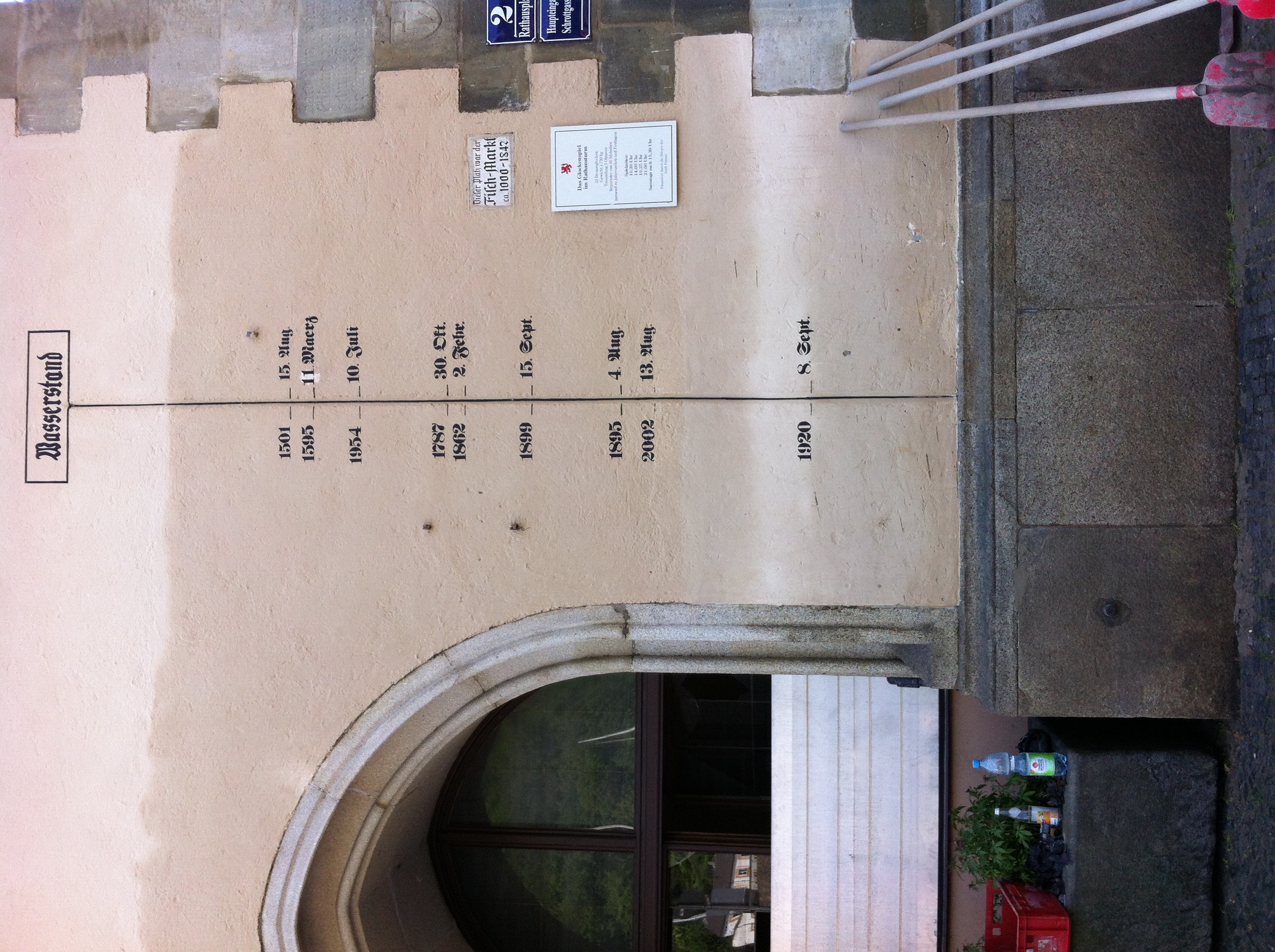
On 3 June 2013 the discharge of the Inn in Passau reached 6,820 m3/s and the water levels reached 12.85 m, the highest recorded historic flood level since 1501. The historic centre of Passau, where the Danube, Inn and Ilz converge, was flooded severely.
Hydroelectric power plants
Currently, there are 24 hydroelectric power plants on the Inn. 17 of them are operated by Verbund AG. The power plants are listed beginning at the headwaters:
| Dam | Nameplate capacity (MW) | Annual generation (Mio. kwh) |
|---|---|---|
| Islas | 4.3 | 17 |
| Ova Spin | 50 | 100 |
| Pradella | 288 | 1,000 |
| Martina | 70 | 290 |
| Imst | 89 | 550 |
| Kirchbichl | 19.3 | 131 |
| Langkampfen | 31.5 | 169 |
| Oberaudorf-Ebbs | 60 | 268 |
| Nussdorf | 48 | 245.8 |
| Rosenheim | 35 | 179.5 |
| Feldkirchen | 38 | 204 |
| Wasserburg | 29 | 165.7 |
| Teufelsbruck | 25 | 150.4 |
| Gars | 30 | 169.2 |
| Jettenbach | 6 | 30.2 |
| Töging | 85 | 564.6 |
| Neuötting | 26 | 159.4 |
| Perach | 19 | 128.4 |
| Stammham | 23 | 136.4 |
| Braunau-Simbach | 100 | 550 |
| Ering-Frauenstein | 72 | 434 |
| Egglfing-Obernberg | 84 | 485 |
| Schärding-Neuhaus | 96 | 541.8 |
| Passau-Ingling | 86 | 504.7 |
References
|archive-url = https://web.archive.org/web/20160419115933/http://engadin-strom.ch/anlagen/zentrale-ova-spin.html |url-status = dead |archive-date = 19 April 2016 |access-date = 2016-01-18
|access-date = 2016-01-18 |archive-date = 25 March 2016 |archive-url = https://web.archive.org/web/20160325202028/http://www.ekwstrom.ch/anlagen/zentrale-pradella.html |url-status = dead
| access-date = 2016-04-05
| access-date = 2016-04-05
|access-date = 2016-01-18 |archive-date = 2 December 2015 |archive-url = https://web.archive.org/web/20151202091822/http://www.stmoritz-energie.ch/ueber-uns/portrait/elektrizitaets-produktion.html |url-status = dead
| access-date = 2016-01-18
| access-date = 2016-01-18
| access-date = 2016-01-18
| access-date = 2016-01-18 | archive-url = https://web.archive.org/web/20160306112158/http://www.verbund.com/pp/en/waters/inn | archive-date = 2016-03-06 | url-status = dead
References
- (2000). "Barrington Atlas of the Greek and Roman World: Map-By-Map Directory". Princeton University Press.
- "Wolf-Armin Frhr. v. Reitzenstein: Lexikon bayerischer Ortsnamen. Herkunft und Bedeutung. C.H.Beck, Munich 2006
- Otto Stolz: ''Geschichtskunde der Gewässer Tirols.'' Schlern-Schriften, Band 32, Innsbruck 1932, S. 6–14 und 83–88 ([http://dza.tessmann.it/tessmannPortal/Medium/Seite/12721/19 Digitalisat])
- Arnaud Vendryes: ''L'Ain : le nom d'une rivière à travers les sources.'' In: Société d'Emulation du Jura, Travaux 2015, S. 147–168
This article was imported from Wikipedia and is available under the Creative Commons Attribution-ShareAlike 4.0 License. Content has been adapted to SurfDoc format. Original contributors can be found on the article history page.
Ask Mako anything about Inn (river) — get instant answers, deeper analysis, and related topics.
Research with MakoFree with your Surf account
Create a free account to save articles, ask Mako questions, and organize your research.
Sign up freeThis content may have been generated or modified by AI. CloudSurf Software LLC is not responsible for the accuracy, completeness, or reliability of AI-generated content. Always verify important information from primary sources.
Report