From Surf Wiki (app.surf) — the open knowledge base
Indo-Gangetic Plain
Geographical plain in South Asia
.png)
Geographical plain in South Asia
| Field | Value |
|---|---|
| name | Indo-Gangetic Plain |
| settlement_type | Geographical region |
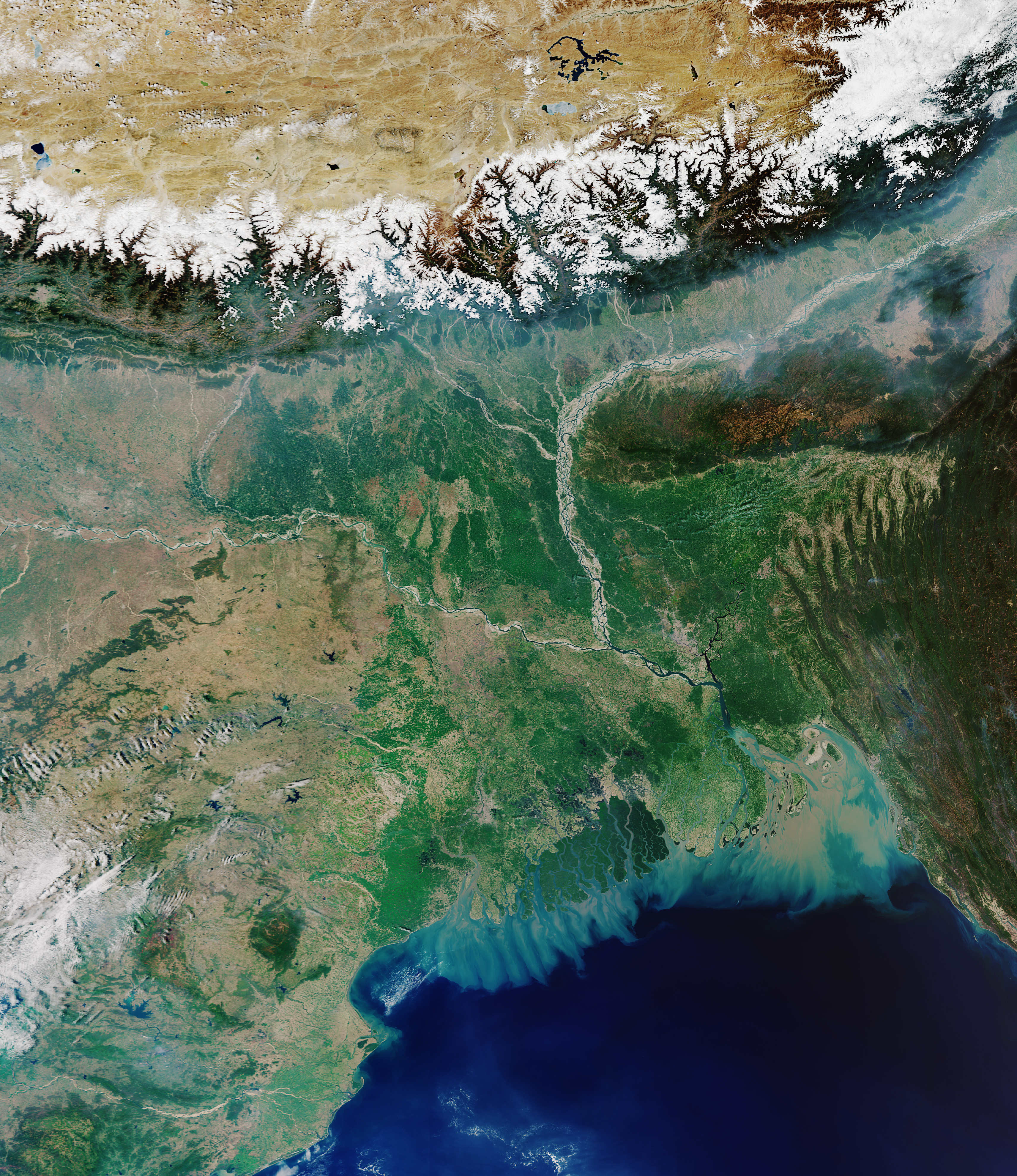
| image_map | Indo-Gangetic Plain.png |
| map_caption | Map of the Indo-Gangetic Plain |
| subdivision_type | Country |
| subdivision_name | India, Pakistan, Bangladesh, Nepal |
| area_total_km2 | 700000 |
The Indo-Gangetic Plain, also known as the North Indian Plain or the Indus-Gangetic Plain, is a fertile plain spanning 700000 km2 across the northern and north-eastern part of the Indian subcontinent. It encompasses northern and eastern India, eastern Pakistan, southern Nepal, and almost all of Bangladesh. It is named after the two major river systems that drain the region–Indus and Ganges.
It stretches from the Himalayas in the north to the northern edge of the Deccan Plateau in the south, and extends from North East India in the east to the Iranian border in the west. The region is home to many major cities and nearly one-seventh of the world's population. As the region was formed by the deposits of the three major rivers–Indus, Ganges and Brahmaputra, the plains consists of the world's largest expanse of uninterrupted alluvium. Due to its rich water resources, it is one of the world's most densely populated and intensely farmed areas.
History
The region was home to the Indus Valley Civilisation in 3000 BCE, which was one of the earliest human settlements in the Indian subcontinent. During the Vedic period (c. 1500 – 600 BCE), the region was referred to as "Aryavarta" (Land of the Aryans). According to Manusmṛti (2.22), 'Aryavarta' is "the tract between the Himalaya and the Vindhya ranges, from the Eastern Sea (Bay of Bengal) to the Western Sea (Arabian Sea)". The region was part of what was historically referred to as Hindustan, a term used to refer to the whole of the Indian subcontinent. The term "Hindustani" is also commonly used to refer to the people, music, and culture of the region.
The fertile terrain facilitated the rise and expansion of various empires such as the Mauryas, Kushan, Guptas, all of whom had their demographic and political centers in the Indo-Gangetic plain. The Maurya Empire existed from 4th to 2nd century BCE and unified most of the Indian subcontinent into one state, and was the largest empire ever to exist on the Indian subcontinent. The Kushan Empire expanded out of what is now Afghanistan into the northwest of the Indian subcontinent in the middle of the 1st century CE. Maritime trade along the Silk Road flourished during the period. The Gupta period existed from the 4th to 7th century CE and is noted for its arts, architecture and science.
In the 12th century CE, much of the region was ruled by the Rajputs. In 1191 CE, the Rajput king Prithviraj Chauhan unified several Rajput states and defeated the invading army of Shihabuddin Ghori in the First Battle of Tarain. However, Shihabuddin defeated the Rajputs in the Second Battle of Tarain, which led to the rise of the Delhi Sultanate in the region in the 13th century CE. In 1526 CE, Babur swept across the Khyber Pass and established the Mughal Empire, which ruled for almost the next three centuries.
The Maratha Empire founded by Chatrapati Shivaji, briefly captured the region in the early 18th century CE. The Sikh Empire was established by Ranjit Singh around the same time in the north western part of the region. The Europeans arrived in the end of the 15th century CE in peninsular India. The English East India company's in the Battle of Plassey (1757) and Battle of Buxar (1764) consolidated the company's power in the lower Gangetic plain. With the defeat of the Marathas, the entire region came under the control of British Raj and remained same until the Indian Independence in 1947.
Geology

The plains were named after the two major river systems that drain the region–Indus and Ganges. The region was formed as a result of continuous deposition of silt by the major river systems of Indus, Ganges and Brahmaputra in the depression that existed between the Himalayas in the north and Deccan Plateau in the south. There are different theories about how the depression was formed. Darashaw Wadia, said the depression was a furrow that existed since the formation of the plateau in the south and the mountains in the north. Edward Suess suggested that the depression was a large syncline that was formed when the southward advance of the Himalayas was blocked by the Indian landmass.
Sydney Burrard opined that the region was a deep rift that existed in the Earth's crust, which was subsequently filled with alluvium. He also pointed out the existence of other rift valleys in the Himalayan and Deccan plateau region. However, geologists such as Ferdinand Hayden and Richard Oldham have rejected this stating that there is no evidence of existence of a rift valley and that the existence of such a large rift valley is not possible. According to the recent research, sediment deposited at the bed of the pre-historic Tethys Sea folded towards the northern end due to the northward drift of the Indian plate and a trough was formed later due to the emergence of the Himalayas in the north. Beneath the silt deposition, the region rests on hard crystalline rocks which connect the Himalayan region with the peninsula. As the region was formed by the deposits of major rivers, the plains consists of the world's largest expanse of uninterrupted alluvium.
Geography

The fertile plains span 700000 km2 across the northern and north-eastern part of the Indian subcontinent. It encompasses northern and eastern India, eastern Pakistan, southern Nepal, and almost all of Bangladesh. Its stretches from the Himalayas in the north to the Vindhyas and Satpura and the Chota Nagpur Plateau in the south in the south, and extends from North East India in the east to the Iranian border in the west. The region is home to many major cities and nearly one-seventh of the world's population. In India, it mainly encompasses the states and union territories of Rajasthan in the west, Punjab, Haryana, Chandigarh, and Delhi in the north west, Uttar Pradesh in the north, Bihar and West Bengal in the east, and Assam in the north east.
The Indo-Gangetic Plain is divided into two drainage basins by the Delhi Ridge, which is a northern extension of the Aravalli Hills. The western part is drained by the Indus, and the eastern part consists of the Ganga–Brahmaputra river systems. The plains encompassed four distinct geographical regions:
- Bhabar: It is a narrow region about 7-15 km wide, located immediately below the foothills of the Himalayas. The stretch is highly porous and is largely made up of stones and rocks carried by the rivers. Most streams disappear underground in the region.
- Terai: It is the second strip that lies next to the Bhabar region. The region is largely made up of new silt deposited by the streams and rivers which reappear. It receives heavy rains for most of the year and consists of thick wet evergreen vegetation.
- Bangar: The third strip consists of older alluvium deposited by the rivers and forms the major fertile region of the flood plains. It also consists of laterite deposits.
- Khadir: The last region encompasses low-lying areas south of the Bangar belt. It is largely composed of new silt carried by the rivers while flowing through the upper part of the plains.
Hydrography and climate
The region is drained by three major river systems and has a high ground water table. Due to its rich water resources and fertile alluvial soil, it is one of the world's most densely populated and intensely farmed areas. The eastern part of the plain receives heavy rainfall during the monsoon after summer, which commonly results in floods and inundations. The rainfall decreases from the east towards the west with the western region encompassing drier areas such as the Thar desert.
Sub-divisions
The region can be sub-divided into various geographical units such as the Sindh Plains, and the Indus Delta in Pakistan; Rajasthan Plain, and Punjab-Haryana Plain in India and Pakistan, Ganga Plain in India and Bangladesh, Brahmaputra Valley in India, Terai region in Nepal, and the Ganges-Brahmaputra Delta in India and Bangladesh.
Sindh Plains


The Sindh Plains forms the western part of the plains and encompasses the Sindh region of Pakistan to the west of the Thar Desert with the Punjab Plains in the north and the Indus River Delta in the south. The region receives about 13 in of rain annually, mostly from June to September. The economy is largely based on agriculture.
Indus Delta
The Indus River Delta encompasses the region where the Indus River flows into the Arabian Sea. Most of the delta lies in the southern Sindh province of Pakistan with a small portion in the Kutch region of India. The delta covers an area of about 41,440 km2, and is approximately 210 km across where it meets the sea. The climate is arid, the region receives only 25 and of rainfall. Since the 1940s, the delta has received less water as a result of large-scale irrigation works capturing large amounts of the Indus water before it reaches the delta. The region is home to the largest arid mangrove forests in the world. The population of the active part of the delta was estimated at 900,000 in 2003 with fishing being the major industry.
Rajasthan Plain
The Rajasthan Plains form the western extreme of the plains in India and is mostly composed of Thar Desert, which occupies an area of 200000 km2 stretching across 650 km. About three-fourth of the plains lie in India and rest in Pakistan. In India, two-thirds of the region is part of western Rajasthan, extending to the west of Aravalli Hills and rest form parts of Haryana, Punjab and Gujarat. The region has an average elevation of 325 m which reduces from east to west, reaching about 150 m towards the Indus delta and the Rann of Kutch. The western part of the region is covered by shifting sand dunes (dharian) and the eastern part of the region (Rajasthan Bagar) is rocky. The region is largely arid with seasonal streams uch as Luni supporting limited agriculture.
Punjab and Haryana Plain
The Punjab-Haryana Plain lies to the east and north east of the Rajasthan Plain. It extends for a length of 640 km in a north west to south east orientation till the Aravalli Hills and is about 300 km wide stretching from Haryana in India into Pakistan's Punjab Province. The elevation varies from 275 m in the north to 176 m in the south west. The left quarter of the region is drained mainly by the tributaries of Indus–Ravi, Beas, and Sutlej and the Yamuna waters a small portion on the eastern border. The in-between land which encompasses the city of Delhi, largely consists of no major streams except the seasonal Ghaggar River, and Sahibi River. The region has a humid subtropical climate with dry winters and receives the major part of rainfall during the south west monsoon between July and September.
Ganga Plain

The Ganga Plain forms the largest sub-unit of the plains and encompasses an area of 375000 km2 across the states of Uttar Pradesh, Bihar, and West Bengal. The Ganges along with its tributaries such as the Yamuna, Gomti, Ghagara, Gandak, Chambal, Kosi, and Sone drain the region. The various rivers and streams originating from both the Himalayas and the Deccan Plateau contribute to fertile soil in the region. The region gently slopes towards the south east and consists of three regions: Upper, Middle and Lower Ganga Plains. The Upper Ganga Plain stretches 149000 km2 from the Shivalik range in the north and the Deccan Plateau in the south with the Yamuna River forming the rough western boundary. The region extends 550 km in the north–south direction and is about 380 km wide with an average elevation of 100–300 m.
The Middle Ganga Plain stretches to the east of the Upper Ganga plain and forms part of eastern Uttar Pradesh and Bihar. It covers an area of 144,000 km2, stretching 330 km in north–south direction and 600 km in the east–west direction. The elevation varies from 100 m in the western boundary to 30 m towards the south east. This plain is largely drained by Ghaghara, Gandak and Kosi rivers. The Lower Ganga Plain includes parts of Bihar, West Bengal and most of Bangladesh. It stretches for 81000 km2 along a 580 km stretch from the foothills of the Himalayas in the north to the Bay of Bengal in the south, and extends between the Chota Nagpur Plateau in the west and Bangladesh's eastern boundary with India. The average elevation is 50 m along the western boundary.
Brahmaputra Valley
The Brahmaputra Valley largely covers the Indian state of Assam and is an eastern extension of the plains. It stretches from the Eastern Himalayas in Arunachal Pradesh in the north, to the Garo-Khasi-Jaintia and Mikir Hills in the south. It has the Patkai and Naga Hills to the east and the boundary of the Lower Ganga Plain to the west. The region covers an estimated 56000 km2 and is watered by Brahmaputra and its tributaries. The elevation varies from 130 m in the east to 30 m in the west.
Ganges-Brahmaputra Delta
The Ganges-Brahmaputra Delta is the river delta formed by the Ganges and Brahmaputra rivers when they enter the Bay of Bengal. Spread over the Bengal region, consisting of Bangladesh and the Indian state of West Bengal, it is the world's largest river delta and is one of the most fertile regions of the plains. The delta stretches from about 260 km from the Hooghly River in the west to the Meghna River in the east. It encompasses an area of more than 100000 km2 with two-thirds of it in Bangladesh. It is also one of the most densely populated regions in the world with more than 130 million inhabitants. The area is prone to heavy tropical cyclones. Agriculture and fishing form important part of the economy in the region.
Notes
References
Bibliography
References
- (23 July 2015). "The Oxford Handbook of Indian Foreign Policy". [[Oxford University Press]].
- (2006). "Temperate Horticulture: Current Scenario". New India Publishing.
- (31 May 2020). "Oceanic Islam: Muslim Universalism and European Imperialism". [[Bloomsbury Publishing]].
- Mark, Joshua J.. "Indus Valley Civilization".
- Gopal, Madan. (1990). "India through the ages". Publication Division, Ministry of Information and Broadcasting, Government of India.
- [[Michael Cook (historian). Michael Cook]] (2014), ''Ancient Religions, Modern Politics: The Islamic Case in Comparative Perspective'', Princeton University Press, p. 68: "Aryavarta ... is defined by Manu as extending from the Himalayas in the north to the Vindhyas of Central India in the south and from the sea in the west to the sea in the east."
- (2019). "Mapping Place Names of India". Taylor & Francis.
- "India". CIA – The World Factbook.
- "Hindustani Classical Music". Indian Melody.
- (December 2006). "East–West Orientation of Historical Empires". Journal of World-Systems Research.
- (1999). "The Cambridge History of Ancient China: From the Origins of Civilization to 221 BC". [[Cambridge University Press]].
- (1986). "Indian Sculpture: Circa 500 B.C.–A.D. 700". University of California Press.
- "Gupta dynasty: empire in 4th century".
- "The Islamic World to 1600: Rise of the Great Islamic Empires (The Mughal Empire)".
- Pearson, M.N.. (February 1976). "Shivaji and the Decline of the Mughal Empire". The Journal of Asian Studies.
- Capper, J.. (1918). "Delhi, the Capital of India". Asian Educational Services.
- Sen, S.N.. (2010). "An Advanced History of Modern India". Macmillan India.
- Singh, Gulcharan. (July 1981). "Maharaja Ranjit Singh and the Principles of War". USI Journal.
- Grewal, J.S.. (1990). "The Sikhs of the Punjab". Cambridge University Press.
- Glenn Ames. (2012). "Portugal and its Empire, 1250–1800 (Collected Essays in Memory of Glenn J. Ames).: Portuguese Studies Review, Vol. 17, No. 1". Trent University Press.
- (2004). "A History of Modern India, 1480–1950". Anthem Press.
- "Indo Gangetic Plain". [[University Grants Commission (India).
- "Indo Gangetic Plain".
- (August 2016). "Production and Technological Gaps in Middle Indo-Gangetic Plains". [[Indian Council of Agricultural Research]].
- Geological Survey of India. (1872). "Records of the Geological Survey of India, Volumes 5–7". Government of India, 1872.
- Lindsay Brown, Amelia Thomas. (2008). "Rajasthan, Delhi and Agra". Lonely Planet, 2008.
- Dinerstein, E., Loucks, C. (2001). {{WWF ecoregion
- (20 July 2021). "Seasonal distribution and drivers of surface fine particulate matter and organic aerosol over the Indo-Gangetic Plain". Atmospheric Chemistry and Physics.
- (3 April 2020). "On the widespread enhancement in fine particulate matter across the Indo-Gangetic Plain towards winter". Scientific Reports.
- (11 April 2009). "Water and the Laws in India". SAGE Publications.
- (1894). "The Indus Delta Country: A Memoir, Chiefly on Its Ancient Geography and History". Kegan Paul, Trench, Trübner & Co..
- "Hazard & Risk Atlases". PMDH.
- (9 March 2014). "Sindh must exploit potential for fruit production". The Nation, 2014.
- "Dates in Sindh". SALU Press.
- "Indus Delta, Pakistan". [[World Wide Fund for Nature]].
- Altaf A. Memon. (14–19 May 2005). "World Water & Environmental Resources Congress 2005". [[American Society of Civil Engineers]].
- "Indus River Delta". [[World Wide Fund for Nature]].
- (5 May 2020). "Ignored by Pakistan, the Indus delta is being lost to the sea".
- Peter J. Hogarth. (2007). "The biology of mangroves and seagrasses". [[Oxford University Press]].
- (May 2003). "Indus Delta, Pakistan: economic costs of reduction in freshwater flow". [[International Union for Conservation of Nature]].
- (21 June 1987). "Life in Bangladesh Delta: On the Edge of Disaster". [[The New York Times]].
- (25 April 2017). "Where Is The Largest Delta In The World?".
- "Ganges delta".
- "Ganges-Brahmaputra Delta". Delta alliance.
- "History and Society/Disasters/Cyclone Deaths".
- Bowden, Rob. (2003). "The Ganges". Heinemann-Raintree Library.
This article was imported from Wikipedia and is available under the Creative Commons Attribution-ShareAlike 4.0 License. Content has been adapted to SurfDoc format. Original contributors can be found on the article history page.
Ask Mako anything about Indo-Gangetic Plain — get instant answers, deeper analysis, and related topics.
Research with MakoFree with your Surf account
Create a free account to save articles, ask Mako questions, and organize your research.
Sign up freeThis content may have been generated or modified by AI. CloudSurf Software LLC is not responsible for the accuracy, completeness, or reliability of AI-generated content. Always verify important information from primary sources.
Report