From Surf Wiki (app.surf) — the open knowledge base
Hunyad County
County of the Kingdom of Hungary
County of the Kingdom of Hungary
| Field | Value |
|---|---|
| native_name | |
| conventional_long_name | Hunyad County |
| common_name | Hunyad |
| subdivision | County |
| nation | the Kingdom of Hungary |
| (1265–1526) | |
| County of the Eastern Hungarian Kingdom | |
| (1526–1570) | |
| County of the Principality of Transylvania | |
| (1570–1867) | |
| County of the Kingdom of Hungary | |
| (1867–1920) | |
| year_start | 1265 |
| event_end | Treaty of Trianon |
| date_end | 4 June 1920 |
| image_coat | Coa_Hungary_County_Hunyad_(history).svg |
| image_map | Hunyad vármegye Magyarországon.svg |
| capital | Déva |
| coordinates | |
| stat_area1 | 7809 |
| stat_pop1 | 340100 |
| stat_year1 | 1910 |
| today | Romania |
| footnotes | Deva is the current name of the capital. |
(1265–1526) County of the Eastern Hungarian Kingdom (1526–1570) County of the Principality of Transylvania (1570–1867) County of the Kingdom of Hungary (1867–1920) Hunyad (today mainly Hunedoara) was an administrative county (comitatus) of the Kingdom of Hungary, of the Eastern Hungarian Kingdom and of the Principality of Transylvania. Its territory is now in Romania in Transylvania. The capital of the county was Déva (present-day Deva).
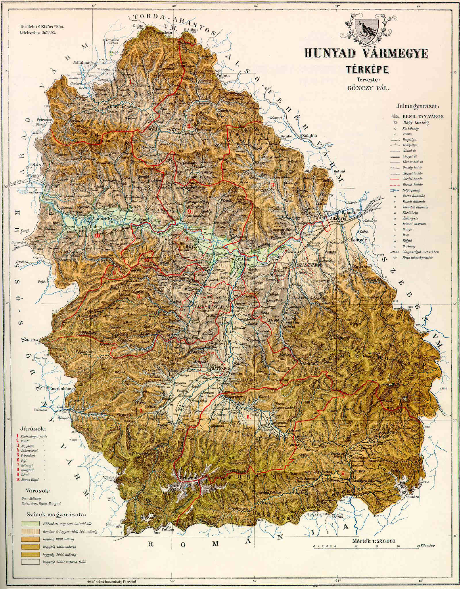
Geography
After 1876, Hunyad county shared borders with Romania and the Hungarian counties Krassó-Szörény, Arad, Torda-Aranyos, Alsó-Fehér and Szeben. Its area was 7,809 km2 around 1910.
Etymology
The toponym Hunyad most likely comes from the Hungarian huny verb, meaning 'to close' or 'to die'. According to linguist Géza Kuun, the name may keep the memory of the Huns.
History


The first known civilization living on the territory were the Scythian Agathyrsi and Sigynnae. Later the Dacians under their leader Burebista established solid control over the territory, but were conquered and massacred by the Roman Empire. Hunyad was part of Roman Dacia for a short time, but by the 3rd century it was occupied by the Goths, later by the Vandals and Gepids. The nomadic Avars conquered Transylvania in 567, and remained the ethnic majority even after the collapse of their khaganate. The Igech, Szerekes, Andos and Zeyk noble families are all of Avar origin, along with the name of the river Zsil.
Hunyad county was formed in the Middle Ages. It was first attested in 1265 as Hungnod by the Papal Quitrent Register.
The battle between John Hunyadi and Mezid Bey, fought within the Kingdom of Hungary: Older historiography places it at Szeben in Transylvania, while modern historiography locates the battle at the Iron Gate Pass (Vaskapu in Hungarian) in Hunyad county, southwestern Transylvania.
In 1876, when the administrative structure of Transylvania was changed, its territory was modified to include about two thirds of the former Zaránd County (Brád/Brad and Körösbánya/Baia de Criș districts) and the Saxon seat of Broos/Orăștie. In 1920, by the Treaty of Trianon, the county became part of Romania. Most of its territory lies in the present Romanian county Hunedoara; a strip in the east is now part of Alba and a strip in the west is now part of Caraș-Severin County (the commune Băuţar).
Demographics

| Census | Total | Romanian | Hungarian | German | Other or unknown | 1880 | 1890 | 1900 | 1910 |
|---|---|---|---|---|---|---|---|---|---|
| 248,464 | 217,414 (90.28%) | 12,278 (5.10%) | 6,968 (2.89%) | 4,166 (1.73%) | |||||
| 267,895 | 238,486 (89.02%) | 17,167 (6.41%) | 8,047 (3.00%) | 4,195 (1.57%) | |||||
| 303,838 | 257,013 (84.59%) | 32,316 (10.64%) | 9,189 (3.02%) | 5,320 (1.75%) | |||||
| 340,135 | 271,675 (79.87%) | 52,720 (15.50%) | 8,101 (2.38%) | 7,639 (2.25%) |
| Census | Total | Eastern Orthodox | Greek Catholic | Roman Catholic | Calvinist | Jewish | Lutheran | Other or unknown | 1880 | 1890 | 1900 | 1910 |
|---|---|---|---|---|---|---|---|---|---|---|---|---|
| 248,464 | 177,725 (71.53%) | 48,381 (19.47%) | 11,883 (4.78%) | 6,568 (2.64%) | 1,996 (0.80%) | 1,799 (0.72%) | 112 (0.05%) | |||||
| 267,895 | 190,018 (70.93%) | 50,520 (18.86%) | 15,121 (5.64%) | 7,351 (2.74%) | 2,470 (0.92%) | 2,202 (0.82%) | 213 (0.08%) | |||||
| 303,838 | 204,350 (67.26%) | 55,116 (18.14%) | 24,993 (8.23%) | 11,398 (3.75%) | 4,056 (1.33%) | 3,269 (1.08%) | 656 (0.22%) | |||||
| 340,135 | 217,425 (63.92%) | 60,024 (17.65%) | 34,668 (10.19%) | 16,675 (4.90%) | 5,679 (1.67%) | 4,110 (1.21%) | 1,554 (0.46%) |
Subdivisions

In the early 20th century, the subdivisions of Hunyad County were:
| Districts (járás) | District | Capital | Urban districts (rendezett tanácsú város) |
|---|---|---|---|
| Algyógy | Algyógyalfalu (now Geoagiu) | ||
| Brád | Brád (now Brad) | ||
| Déva | Déva (now Deva) | ||
| Hátszeg | Hátszeg (now Hațeg) | ||
| Kőrösbánya | Kőrösbánya (now Baia de Criș) | ||
| Marosillye | Marosillye (now Ilia) | ||
| Petrozsény | Petrozsény (now Petroșani) | ||
| Puj | Puj (now Pui) | ||
| Szászváros | Szászváros (now Orăștie) | ||
| Vajdahunyad | Vajdahunyad (now Hunedoara) | ||
| Déva (now Deva) | |||
| Hátszeg (now Hațeg) | |||
| Szászváros (now Orăștie) | |||
| Vajdahunyad (now Hunedoara) |
Notes
Sources
References
References
- (1902). "Hunyadvármegye története". Irodalmi Szemle.
- (1902). "Hunyadvármegye története". Irodalmi Szemle.
- Tarján M., Tamás. "Hunyadi János legyőzi a törököket Szebennél". Rubicon (Hungarian Historical Information Dissemination).
- Bánlaky, József. "A magyar nemzet hadtörténelme".
- Pálosfalvi, Tamás. (2001). "Az 1442. márciusi török hadjárat – Adalékok Hunyadi János első törökellenes harcaihoz". Magyar Tudományos Akadémia Bölcsészettudományi Kutatóközpont Történettudományi Intézet [The Hungarian Academy of Sciences – Research Centre for the Humanities – Institute of History].
- Weiss, David. (2020). "The Ottoman campaign in Wallachia and the Battle on the River Ialomița (1442)".
- Ágoston, Gábor. (April 2025). "Oszmán hódítók és az "átkozott Jankó"". Rubicon Historical Magazine.
- Fedeles, Tamás. (April 2025). "Csillag születik – Hunyadi törökverő nimbusza". Rubicon Historical Magazine.
- "Az 1881. év elején végrehajtott népszámlálás főbb eredményei megyék és községek szerint rendezve, II. kötet (1882)". library.hungaricana.hu.
- "A Magyar Korona országainak helységnévtára (1892)". library.hungaricana.hu.
- "A MAGYAR KORONA ORSZÁGAINAK 1900". library.hungaricana.hu.
- "KlimoTheca :: Könyvtár". Kt.lib.pte.hu.
This article was imported from Wikipedia and is available under the Creative Commons Attribution-ShareAlike 4.0 License. Content has been adapted to SurfDoc format. Original contributors can be found on the article history page.
Ask Mako anything about Hunyad County — get instant answers, deeper analysis, and related topics.
Research with MakoFree with your Surf account
Create a free account to save articles, ask Mako questions, and organize your research.
Sign up freeThis content may have been generated or modified by AI. CloudSurf Software LLC is not responsible for the accuracy, completeness, or reliability of AI-generated content. Always verify important information from primary sources.
Report