From Surf Wiki (app.surf) — the open knowledge base
Hlavenec
| Field | Value |
|---|---|
| name | Hlavenec |
| settlement_type | Municipality |
| image_skyline | Hlavenec letecky.JPG |
| image_caption | Aerial view |
| image_flag | Flag of Hlavenec.jpeg |
| image_shield | Coats of arms Hlavenec.jpeg |
| subdivision_type | Country |
| subdivision_name | |
| subdivision_type1 | Region |
| subdivision_name1 | Central Bohemian |
| subdivision_type2 | District |
| subdivision_name2 | Prague-East |
| pushpin_map | Czech Republic |
| pushpin_relief | 1 |
| pushpin_map_caption | Location in the Czech Republic |
| coordinates | |
| established_title | First mentioned |
| established_date | 1386 |
| area_total_km2 | 14.72 |
| elevation_m | 195 |
| population_as_of | 2025-01-01 |
| population_footnotes | |
| population_total | 481 |
| population_density_km2 | auto |
| timezone1 | CET |
| utc_offset1 | +1 |
| timezone1_DST | CEST |
| utc_offset1_DST | +2 |
| postal_code_type | Postal code |
| postal_code | 294 74 |
| website |
Hlavenec is a municipality and village in Prague-East District in the Central Bohemian Region of the Czech Republic. It has about 500 inhabitants.
Etymology
The name is a diminutive form of the personal name Hlaven.
Geography
Hlavenec is located about 19 km northeast of Prague. It lies in a flat landscape in the Polabí lowlands, on the border between the Jizera Table and Central Elbe Table. The highest point is the hill Kobylí hlava at 215 m above sea level.
History
The first written mention of Hlavenec is from 1386. It was probably founded together with Kostelní Hlavno and Sudovo Hlavno. The village was owned by the Lords of Michalovice and later was annexed to the Brandýs estate. In 1547, the estate was acquired by the Habsburg family and Hlavenec became known for the imperial game park.
Demographics
|1869|382 |1880|412 |1890|406 |1900|439 |1910|457 |1921|466 |1930|440 |1950|377 |1961|362 |1970|284 |1980|274 |1991|277 |2001|311 |2011|373 |2021|434
Transport
The D10 motorway from Prague to Turnov runs along the eastern municipal border.
Sights
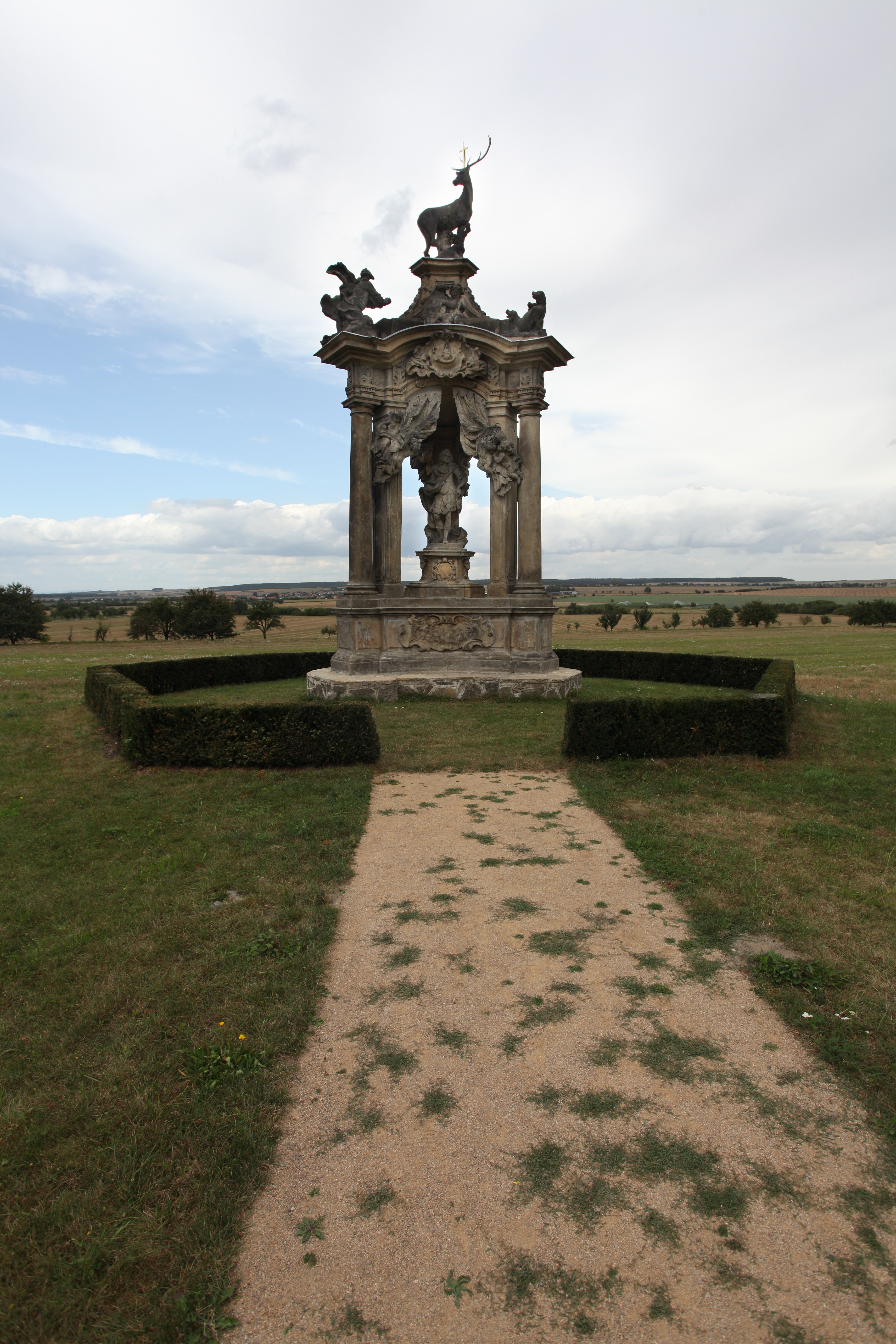
The most important monument is the memorial of Emperor Charles VI. It was made by Matthias Braun in 1724–1725 according to the design by František Maxmilián Kaňka.
References
References
- (2025-05-16). "Population of Municipalities – 1 January 2025". [[Czech Statistical Office]].
- Profous, Antonín. (1947). "Místní jména v Čechách I: A–H".
- "O Hlavenci". Obec Hlavenec.
- (2015-12-21). "Historický lexikon obcí České republiky 1869–2011". [[Czech Statistical Office]].
- (2021-03-27). "Population Census 2021: Population by sex". [[Czech Statistical Office]].
- "Památky". Obec Hlavenec.
This article was imported from Wikipedia and is available under the Creative Commons Attribution-ShareAlike 4.0 License. Content has been adapted to SurfDoc format. Original contributors can be found on the article history page.
Ask Mako anything about Hlavenec — get instant answers, deeper analysis, and related topics.
Research with MakoFree with your Surf account
Create a free account to save articles, ask Mako questions, and organize your research.
Sign up freeThis content may have been generated or modified by AI. CloudSurf Software LLC is not responsible for the accuracy, completeness, or reliability of AI-generated content. Always verify important information from primary sources.
Report