From Surf Wiki (app.surf) — the open knowledge base
Hinatuan
Municipality in Surigao del Sur, Philippines
Municipality in Surigao del Sur, Philippines
| Field | Value | |
|---|---|---|
| name | ||
| image_flag | Flag_of_Hinatuan,_Surigao_del_Sur.png | |
| flag_size | 120x80px | |
| image_seal | Hinatuan-official-seal.png | |
| seal_size | 100x80px | |
| image_map | ||
| map_caption | ||
| mapframe | yes | |
| pushpin_map | Philippines | |
| pushpin_label_position | right | |
| pushpin_map_caption | Location within the | |
| coordinates | ||
| settlement_type | ||
| subdivision_type | Country | |
| subdivision_name | Philippines | |
| subdivision_type1 | Region | |
| subdivision_name1 | ||
| subdivision_type2 | Province | |
| subdivision_name2 | ||
| official_name | ||
| etymology | ||
| named_for | ||
| subdivision_type3 | District | |
| subdivision_name3 | ||
| established_title | Founded | |
| established_date | ||
| parts_type | Barangays | |
| parts_style | para | |
| p1 | (see Barangays) | |
| leader_title | Mayor | |
| leader_name | Tito A. Cañedo III | |
| leader_title1 | Vice Mayor | |
| leader_name1 | Joan M. Garay | |
| leader_title2 | Representative | |
| leader_name2 | Alexander T. Pimentel | |
| leader_title3 | Councilor | |
| leader_title4 | Electorate | |
| leader_name4 | voters (electorate_point_in_time}} | ) |
| government_type | ||
| government_footnotes | ||
| elevation_m | ||
| elevation_footnotes | ||
| area_footnotes | ||
| area_total_km2 | ||
| population_footnotes | ||
| population_total | ||
| population_as_of | ||
| population_density_km2 | auto | |
| population_blank1_title | Households | |
| population_blank1 | ||
| timezone | PST | |
| utc_offset | +8 | |
| postal_code_type | ZIP code | |
| postal_code | ||
| postal2_code_type | ||
| postal2_code | ||
| area_code_type | ||
| area_code | ||
| website | ||
| demographics_type1 | Economy | |
| demographics1_title1 | ||
| demographics1_info1 | ||
| demographics1_title2 | Poverty incidence | |
| demographics1_info2 | % () | |
| demographics1_title3 | Revenue | |
| demographics1_info3 | ||
| demographics1_title4 | Revenue rank | |
| demographics1_title5 | Assets | |
| demographics1_info5 | ||
| demographics1_title6 | Assets rank | |
| demographics1_title7 | IRA | |
| demographics1_title8 | IRA rank | |
| demographics1_title9 | Expenditure | |
| demographics1_info9 | ||
| demographics1_title10 | Liabilities | |
| demographics1_info10 | ||
| demographics_type2 | Service provider | |
| demographics2_title1 | Electricity | |
| demographics2_info1 | ||
| demographics2_title2 | Water | |
| demographics2_title3 | Telecommunications | |
| demographics2_title4 | Cable TV | |
| blank_name_sec1 | ||
| blank_info_sec1 | ||
| blank1_name_sec1 | Native languages | |
| blank1_info_sec1 | ||
| blank2_name_sec1 | Crime index | |
| blank1_name_sec2 | Major religions | |
| blank2_name_sec2 | Feast date | |
| blank3_name_sec2 | Catholic diocese | |
| blank4_name_sec2 | Patron saint |
Hinatuan is a municipality in the province of Surigao del Sur, Philippines. According to the 2020 census, it has a population of 43,841 people.
Hinatuan is approximately 44 kilometers (27 miles) north of Bislig, a city in the same province and 132.7 km (approximately 82.5 miles) north of Tandag, the provincial capital.
History
Pre-Spanish Era
The history of Hinatuan in the annals of historical heritage can be traced back from the time of the Spaniards in this part of Mindanao. The intermingling of tribes such as the Manobos, the Mansakas, Subanons and the Mandayas through assimilation and amalgamation leads to the final unification of a group of people who settled in the old town site known as Da-an Lungsod. Being the first and the earliest settlement, it was later identified as part of the province of Caraga under the administration of the politico - militar of Encomienda Bislig.
The name Hinatuan, originally derived from the word "Hatud" and later called "Hatudan" which was handed down from generation to generation through the oral version. These words have two versions - "Hatud" in the native language is simply known in English as "bring." In fact, fishing is the major occupation of the inhabitants. To denote a place, a suffix "-an" was added to "Hatud" to become "Hatudan".
Spanish Era
The place used to be a pathway where dead bodies of people being transferred to another place and that's why it called "hinatudan" which translates to "a place where (something) is brought". Right until in 1856, the town was transferred to its present site, formerly known as "Hinatudan" now known as Hinatuan as ordered by the higher Spanish authorities. A political government was set up with Raymundo Bandola, the first captain known as defender of the town against the Moro piracy. He was followed by Capitanes Edobigito Lindo, Atanacio de Castro, Tomas Luna, Fernando Nazareno and Teodoro Villaluz. Eugenio Villaluz was accredited the last capitan under the Spanish regime, the first and last captain under the First Philippine Republic, and the first presidential appointee under the American regime. These mentioned capitanes contributed much to the building of the physical set up of the town.
The appointed presidents following Eugenio Villaluz were : Mariano Verano, Pablo Evangelio, Nicomedes Villaluz and Ex-Captain Fernando Nazareno. Domingo Balbuena was the first president - elect and followed by Florencio Villaluz, Antonio Picazales, Victoriano Evangelio, Modesto Raura and Damian Siano. Again, these town executives were responsible for the expansion of the town to a larger area.
Japanese Era
World War II broke out. A few months later, a strong typhoon hit Hinatuan. Heavy damages inflected to both private and public properties especially to buildings, coconut plantations and other potential crops, forest reserves, and machineries and equipment of the Portlamon Lumber Company. Guerrilla activities then sprung up to lessen the influence and strength of the Armed Forces of the Empire of Japan and to prepare the people for liberation of the country by the allied forces.
Modern day
After the war, Elpedio Chavez was appointed mayor of the town. He was later followed by the first-elect, Mayor Tito Cañedo, Sr., under the Republic of the Philippines. He helped much in the rehabilitation and reconstruction of the town. He was followed by Mayor Joaquin Villaluz, Segundo Cuyno, Sr., Candelario Viola, Sr., Jose Pepino, Sr., the mayor under the Martial Law period, LADP scholar Atty. Candelario J. Viola, Jr., Cristina M. Camba, Dr. Alicia V. Momongan, Shem G. Garay and the incumbent Mayor Atty. Tito A. Cañedo III.
Hinatuan was the epicenter of a magnitude 7.6 earthquake on 2 December 2023. It damaged or destroyed nearly 10% of the town's houses. The town's mayor reported that about 41,000 of the town's 43,000 residents were affected.
Geography
Barangays
Hinatuan is politically subdivided into 24 barangays. Each barangay consists of puroks, while some have sitios.
- Baculin
- Bigaan
- Cambatong
- Campa
- Dugmanon
- Harip
- La Casa (Poblacion)
- Loyola
- Maligaya
- Bitoon (formerly pagtigi-an)
- Pocto
- Port Lamon
- Roxas
- San Juan
- Sasa
- Tagasaka
- Tagbobonga
- Talisay
- Tarusan
- Tidman
- Tiwi
- Zone I Benigno Aquino (Poblacion)
- Zone II Santo Niño (Poblacion)
- Zone III Maharlika (Poblacion)
Climate
| Jan record high C = 35.2 | Feb record high C = 33.5 | Mar record high C = 33.5 | Apr record high C = 36.1 | May record high C = 36.6 | Jun record high C = 36.2 | Jul record high C = 37.9 | Aug record high C = 37.2 | Sep record high C = 37.0 | Oct record high C = 36.2 | Nov record high C = 36.0 | Dec record high C = 35.2 | year record high C = 37.9 | Jan record low C = 17.2 | Feb record low C = 18.1 | Mar record low C = 18.2 | Apr record low C = 18.4 | May record low C = 20.3 | Jun record low C = 20.2 | Jul record low C = 19.0 | Aug record low C = 19.0 | Sep record low C = 19.1 | Oct record low C = 19.9 | Nov record low C = 19.0 | Dec record low C = 18.8 | year record low C = 17.2 | archive-url = https://web.archive.org/web/20220308093343/https://pubfiles.pagasa.dost.gov.ph/pagasaweb/files/cad/CLIMATOLOGICAL%20NORMALS%20(1991-2020)/HINATUAN.pdf#toolbar=0&navpanes=0 | archive-date = March 8, 2022 | access-date = August 5, 2024}} | archive-url = https://web.archive.org/web/20181014230737/https://pubfiles.pagasa.dost.gov.ph/pagasaweb/files/cad/CLIMATOLOGICAL%20EXTREMES%20%28as%20of%202023%29/Hinatuan.pdf | archive-date = October 14, 2018 | access-date = October 14, 2018}}
Demographics
Economy
Tourism
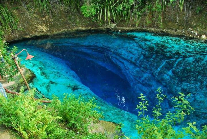
Clear blue waters of the underground river in Barangay Talisay, Hinatuan, popularly called as the "Hinatuan Enchanted River" is a known attraction among tourists both locally and internationally.
References
References
- {{DILG detail
- National Earthquake Information Center. (2 December 2023). "M 7.6 - Mindanao, Philippines". [[United States Geological Survey]].
- (5 December 2023). "DSWD DROMIC Report #2 on the Mw 7.4 Earthquake Incident in Hinatuan, Surigao del Sur as of 04 December 2023, 6PM".
- (4 December 2023). "11,000 families in Hinatuan affected by strong Surigao quake: mayor". ABS-CBN.
This article was imported from Wikipedia and is available under the Creative Commons Attribution-ShareAlike 4.0 License. Content has been adapted to SurfDoc format. Original contributors can be found on the article history page.
Ask Mako anything about Hinatuan — get instant answers, deeper analysis, and related topics.
Research with MakoFree with your Surf account
Create a free account to save articles, ask Mako questions, and organize your research.
Sign up freeThis content may have been generated or modified by AI. CloudSurf Software LLC is not responsible for the accuracy, completeness, or reliability of AI-generated content. Always verify important information from primary sources.
Report