From Surf Wiki (app.surf) — the open knowledge base
Harrachov

| Field | Value |
|---|---|
| name | Harrachov |
| settlement_type | Town |
| image_skyline | Harrachov z.jpg |
| image_caption | Panoramic view |
| image_flag | Harrachov vlajka.jpg |
| image_shield | Harrachov znak.jpg |
| subdivision_type | Country |
| subdivision_name | |
| subdivision_type1 | Region |
| subdivision_name1 | Liberec |
| subdivision_type2 | District |
| subdivision_name2 | Jablonec nad Nisou |
| pushpin_map | Czech Republic |
| pushpin_relief | 1 |
| pushpin_map_caption | Location in the Czech Republic |
| coordinates | |
| leader_title | Mayor |
| leader_name | Tomáš Vašíček |
| established_title | First mentioned |
| established_date | 1720 |
| area_total_km2 | 36.63 |
| elevation_m | 665 |
| population_as_of | 2025-01-01 |
| population_footnotes | |
| population_total | 1388 |
| population_density_km2 | auto |
| timezone1 | CET |
| utc_offset1 | +1 |
| timezone1_DST | CEST |
| utc_offset1_DST | +2 |
| postal_code_type | Postal code |
| postal_code | 512 46 |
| website |
Harrachov (; ) is a town in Jablonec nad Nisou District in the Liberec Region of the Czech Republic, close to the border with Poland. It has about 1,400 inhabitants. It is known as one of the most popular Czech ski resorts.
Administrative division
Harrachov consists of four municipal parts (in brackets population according to the 2021 census):
- Harrachov (503)
- Mýtiny (16)
- Nový Svět (788)
- Ryžoviště (39)
Geography
Harrachov is located about 18 km east of Jablonec nad Nisou, on the border with Poland. It lies in the Giant Mountains. The highest point is the mountain Luboch at 1296 m above sea level. Part of the municipal territory belongs to Krkonoše National Park.
The Mumlava River flows through the town. Its confluence with the Jizera is situated on the municipal border. On the Mumlava there is the Mumlava Waterfall, the biggest and one of the most famous waterfalls in the Czech Republic. It has a flow rate of 800 L/s and a height of 8.9 m.
Climate
|Jan record high C = 10.9 |Feb record high C = 14.9 |Mar record high C = 20.0 |Apr record high C = 27.0 |May record high C = 28.6 |Jun record high C = 32.7 |Jul record high C = 33.6 |Aug record high C = 34.1 |Sep record high C = 31.0 |Oct record high C = 23.7 |Nov record high C = 17.5 |Dec record high C = 11.4 |year record high C = 34.1 |Jan record low C = -27.7 |Feb record low C = -24.0 |Mar record low C = -23.0 |Apr record low C = -13.9 |May record low C = -6.0 |Jun record low C = -3.5 |Jul record low C = 0.2 |Aug record low C = -0.5 |Sep record low C = -5.0 |Oct record low C = -10.1 |Nov record low C = -18.6 |Dec record low C = -23.0 |year record low C = -27.7
History
Harrachov was established in the 17th century, after a glassworks was founded in the area of Ryžoviště, and originally was called just Dörf (German for 'little village'). During the rule of Count Ferdinand Bonaventura Harrach (1701–1706), the settlement was renamed Harrachsdorf in his honor. The first written mention of Harrachov is from 1720. After a glassworks was founded also in the area of Nový Svět in 1711, the importance of Harrachov grew. The settlements of Nový Svět and Ryžoviště were founded around the glassworks in the mid-18th century.
Since the end of the 19th century, Harrachov has been known for its glass production, textile industry, and mining. At the beginning of the 20th century, industrial production was bolstered by the construction of a cog railway line between Bohemian Tanvald via the Izera railway down to Silesian Hirschberg (present-day Jelenia Góra).
After World War II, the Silesian lands in the north fell to the Polish People's Republic according to the Potsdam Agreement and the border was closed. The German population was expelled and its property seized according to the Beneš decrees.
In 1958, the Communist governments of Czechoslovakia and Poland arranged a territorial exchange. Since the railway station located here was unusable for Poland after the interruption of cross-border traffic (the line to Jelenia Góra returned to Czechoslovak territory in a short section) and the local small settlements were almost inaccessible from the Polish side, the territories was exchanged. Czechoslovakia acquired the area around former Strickerhäuser (, present-day Mýtiny). Poland was compensated by land in western Giant Mountains. In this way Harrachov acquired a railway station.
In 1921, the originally independent municipalities of Nový Svět and Rýžoviště joined Harrachov. In 1961, Mýtiny joined Harrachov.
From 1 January 2021, Harrachov is no longer a part of Semily District and belongs to Jablonec nad Nisou District.
Demographics
|1869|1788 |1880|1945 |1890|1750 |1900|1762 |1910|1656 |1921|1410 |1930|1731 |1950|2013 |1961|1282 |1970|1249 |1980|1428 |1991|1667 |2001|1757 |2011|1643 |2021|1346
Transport

The I/10 road (part of the European route E65 from Prague) passes through the town.
Harrachov is located on the railway line from Liberec to Szklarska Poręba.
There are three borders crossings with Poland: the railway crossing Harrachov / Jakuszyce, the road border crossing Harrachov / Jakuszyce, and the pedestrian border crossing Harrachov / Polana Jakuszycka.
Sport
Harrachov is one of the most popular Czech ski resorts including the internationally used Čerťák ski jumping hill (including flying hill); several winter sport events take place in Harrachov regularly. The whole region is increasingly important for alpine tourism in Central Europe.
Sights
The most valuable building is the glass factory, founded in 1712. It is one of the longest-running glassworks in Bohemia that still uses most of the uniquely preserved historical machinery, which makes it an important technical monument. Its best-preserved part is the grinding plant, which is protected as a national cultural monument.
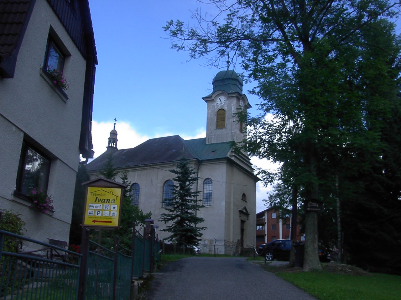
The main landmark of Harrachov is the Church of Saint Wenceslaus. It was built in the Neoclassical style in 1822–1828, on the site of a chapel from 1730 and a wooden church from 1788. The local glass factory took part in the decoration. The interior is equipped with a glass altar.
Twin towns – sister cities
Harrachov is twinned with:
- CZE Frenštát pod Radhoštěm, Czech Republic
References
References
- (2025-05-16). "Population of Municipalities – 1 January 2025". [[Czech Statistical Office]].
- (2022). "Public Census 2021 – basic data". [[Czech Statistical Office]].
- (2017-06-07). "Nejvyšší a největší vodopády ČR". Rekordy přírody.
- "Teplota vzduchu v jednotlivé kalendářní dny". Czech Hydrometeorological Institute.
- "Průměrná teplota vzduchu v jednotlivé měsíce v jednotlivé roky". Czech Hydrometeorological Institute.
- "Srážkové úhrny v jednotlivé měsíce v jednotlivé roky". Czech Hydrometeorological Institute.
- "Množství nového sněhu v jednotlivé měsíce v jednotlivé roky". Czech Hydrometeorological Institute.
- "Průměrná relativní vlhkost vzduchu v jednotlivé měsíce v jednotlivé roky". Czech Hydrometeorological Institute.
- "Délka slunečního svitu v jednotlivé měsíce v jednotlivé roky". Czech Hydrometeorological Institute.
- "Územní plán Harrachov". Město Harrachov.
- (2015-12-21). "Historický lexikon obcí České republiky 1869–2011". Czech Statistical Office.
- "Obecně o novém zákonu č. 51/2020 Sb.". [[Ministry of the Interior (Czech Republic).
- (2015-12-21). "Historický lexikon obcí České republiky 1869–2011". [[Czech Statistical Office]].
- (2021-03-27). "Population Census 2021: Population by sex". [[Czech Statistical Office]].
- "Sklárna". National Heritage Institute.
- "Kostel sv. Václava". National Heritage Institute.
- "O městě". Město Harrachov.
This article was imported from Wikipedia and is available under the Creative Commons Attribution-ShareAlike 4.0 License. Content has been adapted to SurfDoc format. Original contributors can be found on the article history page.
Ask Mako anything about Harrachov — get instant answers, deeper analysis, and related topics.
Research with MakoFree with your Surf account
Create a free account to save articles, ask Mako questions, and organize your research.
Sign up freeThis content may have been generated or modified by AI. CloudSurf Software LLC is not responsible for the accuracy, completeness, or reliability of AI-generated content. Always verify important information from primary sources.
Report