From Surf Wiki (app.surf) — the open knowledge base
Hannington, Wiltshire
Village in Wiltshire, England
Village in Wiltshire, England
| Field | Value |
|---|---|
| official_name | Hannington |
| country | England |
| region | South West England |
| static_image_name | Hannington Hall, Hannington, Swindon (1) - geograph.org.uk - 624422.jpg |
| static_image_caption | Hannington Hall |
| population | 243 |
| population_ref | (in 2021) |
| os_grid_reference | SU175933 |
| coordinates | |
| post_town | SWINDON |
| postcode_area | SN |
| postcode_district | SN6 |
| dial_code | 01793 |
| constituency_westminster | Swindon North |
| civil_parish | Hannington |
| unitary_england | Swindon |
| lieutenancy_england | Wiltshire |
| website |
Hannington is a village and civil parish in Wiltshire, England, about 2 mi north-west of Highworth, within the Borough of Swindon. The parish includes the hamlets of Hannington Wick (north of Hannington village) and Swanborough (south, on the border with Highworth parish). The River Thames forms both the northern boundary of the parish and the county boundary with Gloucestershire.
John Marius Wilson of the Imperial Gazetteer of England and Wales in 1870 described the village of Hannington as:A village and a parish in Highworth district, Wilts. The village stands 2 miles W by N of Highworth, 2 S of the river Thames at the boundary with Gloucester, and 7 NE of Swindon Junction r. station; is a pretty place, built in the form of the letter Y; and has a post office under Swindon.
Demographics
Population
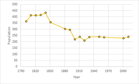
The parish of Hannington had a population of 240 at the 2011 census. 433 people lived in Hannington in 1841. Numbers then steadily declined, and since the 1940s the parish population has plateaued around the 250 mark.
Occupations

The occupations recorded for the parish in 1881 are shown in the graph (left). They were dominated by agriculture with 46 people, almost all male, while those employed in domestic service were almost all female.
Hannington Hall
Hannington Hall is a Grade II* listed country house built in 1653, which has been a centrepiece of the village since Sir Thomas Freke commissioned and paid for its construction. The grounds of the hall are dotted with buildings associated with the running of the estate such as the Victorian stable block.
Parish church

Today, the church is within the benefice of Highworth with Sevenhampton and Inglesham and Hannington, centred on St Michael's church at Highworth.
Transport

The minor road running through the village connects to the B4019 Blunsdon-Highworth road to the south, giving access to the M4 motorway via the A419. The road north through Hannington Wick continues to Kempsford, and another minor road leads north-west to Castle Eaton.
The village has been without access to the rail network since 1962 when the Highworth branch line closed following declining passenger numbers. The branch from to Highworth was opened in 1883, over forty years after the main line was built through Swindon. station was about a mile south-east of the village, near the Blunsdon to Highworth road; there were other intermediate stations at Stratton and Stanton Fitzwarren.
Notable people
- Thomas Freke (1660–1721)
References
References
- "Hannington: population statistics".
- Marius, John. (1870–1872). "Imperial Gazetteer of England and Wales". A. Fullerton & Co..
- "Hannington Census Information". Wiltshire Council.
- "Occupation data classified into the 24 1881 'Orders', plus sex".
- {{National Heritage List for England entry
- {{National Heritage List for England
- (10 February 2009). "Hannington Conservation Area Appraisal and Management Plan".
- (2021). "Wiltshire". [[Yale University Press]].
- "St John the Baptist, Hannington, Wiltshire". King's College London.
- {{National Heritage List for England
- "Our Churches".
- "Geograph:: Disused station platform, Hannington... (C) Vieve Forward".
- G, Heathcliffe. (1984). "Highworth Light Railway".
- (1896). "Ordnance Survey One-inch sheet 252: Swindon".
- "FREKE, Thomas II (1660-1721), of Hannington, Wilts. {{!}} History of Parliament Online".
This article was imported from Wikipedia and is available under the Creative Commons Attribution-ShareAlike 4.0 License. Content has been adapted to SurfDoc format. Original contributors can be found on the article history page.
Ask Mako anything about Hannington, Wiltshire — get instant answers, deeper analysis, and related topics.
Research with MakoFree with your Surf account
Create a free account to save articles, ask Mako questions, and organize your research.
Sign up freeThis content may have been generated or modified by AI. CloudSurf Software LLC is not responsible for the accuracy, completeness, or reliability of AI-generated content. Always verify important information from primary sources.
Report