From Surf Wiki (app.surf) — the open knowledge base
Gyftokampos
Gyftokampos () is an area ιn the Zagori region (Epirus region), 58 km north of Ioannina. Its name is derived from the Greek "gyftos" (γύφτος), gypsy and "kampos" () that means "field", and could be rendered in English translation as "gypsy lea". There used to be a hamlet called Nouka on this location which was also used by the Sarakatsani as pasture grounds. The area, located at the base of Mt Tymfi, has traditionally belonged to the village of Skamneli and it forms part of the municipality of Tymfi.
History
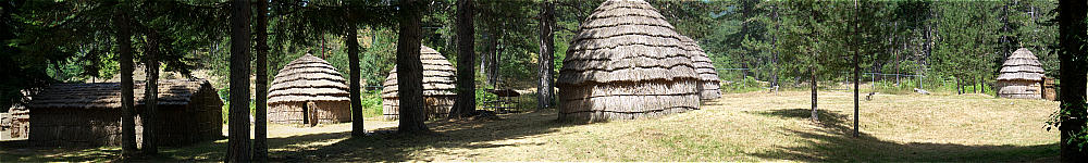
Until the early 20th century, the area was open and used as a grazing ground by the Sarakatsani . It has become gradually wooded by coniferous trees, including impressive Scots pines. Huts of Sarakatsani were in use until the 1990s. Today an open-air "museum" with typical Sarakatsani huts and animal enclosures has been built. The area is used for an annual Sarakatsani festival in the first week of August.
Sources
- www.timfi.gov.gr (in Greek)
el:Γυφτόκαμπος Ιωαννίνων
This article was imported from Wikipedia and is available under the Creative Commons Attribution-ShareAlike 4.0 License. Content has been adapted to SurfDoc format. Original contributors can be found on the article history page.
Ask Mako anything about Gyftokampos — get instant answers, deeper analysis, and related topics.
Research with MakoFree with your Surf account
Create a free account to save articles, ask Mako questions, and organize your research.
Sign up freeThis content may have been generated or modified by AI. CloudSurf Software LLC is not responsible for the accuracy, completeness, or reliability of AI-generated content. Always verify important information from primary sources.
Report