From Surf Wiki (app.surf) — the open knowledge base
Gulf Islands National Seashore
American seashore along the Gulf of Mexico

American seashore along the Gulf of Mexico
| Field | Value |
|---|---|
| name | Gulf Islands National Seashore |
| iucn_category | V |
| photo | Gulf Islands NS.jpg |
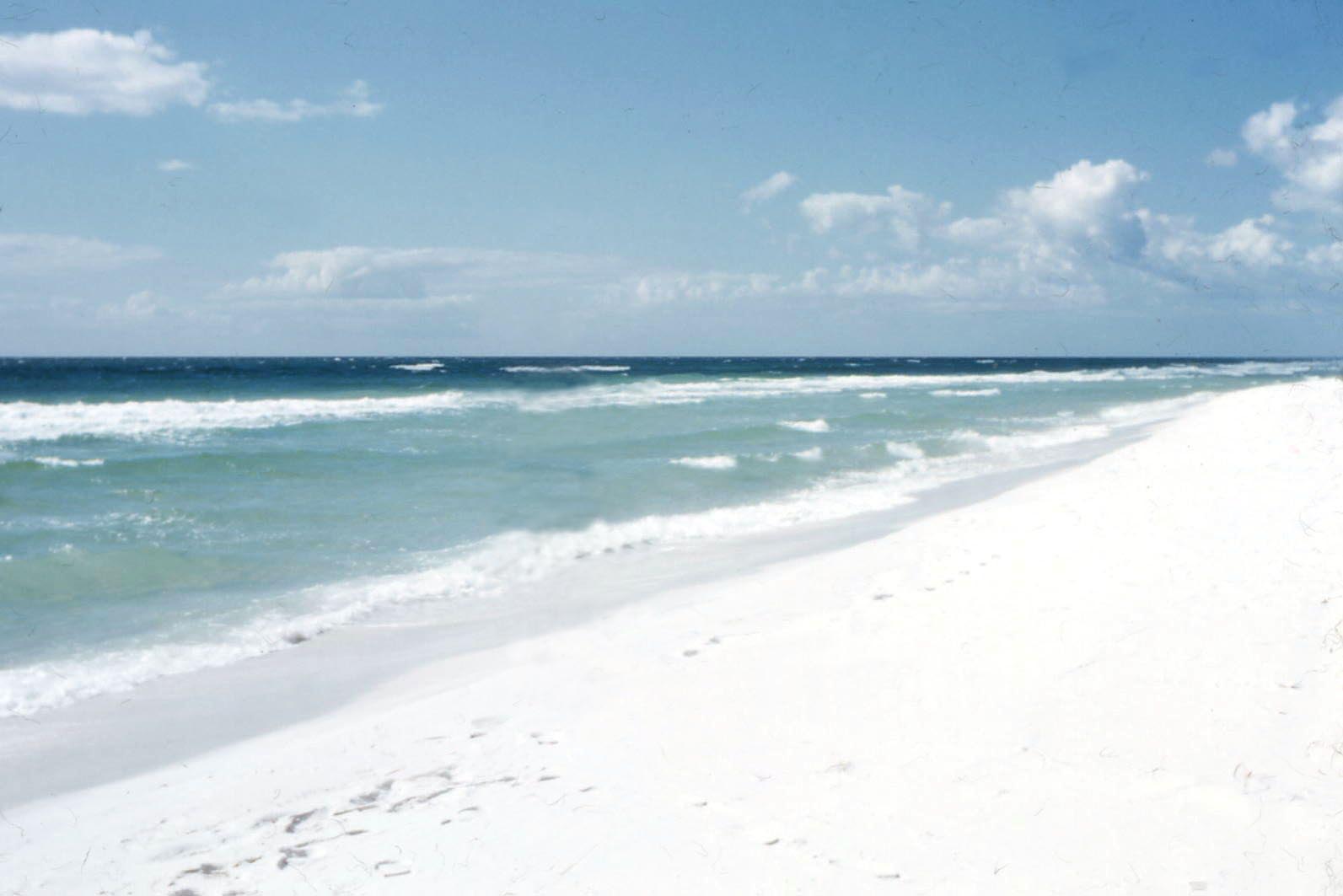
| photo_caption | Gulf Islands National Seashore, near Pensacola |
| map | Florida#USA |
| relief | 1 |
| map_caption | Gulf Islands National Seashore |
| location | Escambia / Santa Rosa / Okaloosa counties, Florida; Baldwin County and Mobile County, Alabama; and Jackson / Harrison counties, Mississippi; USA |
| nearest_city | Mobile, Alabama, Pensacola, FL (Fort Barrancas) |
| Navarre, FL (Santa Rosa Island area) | |
| Gulf Breeze, FL (Naval Live Oaks area) | |
| Destin, FL (Okaloosa Island area) | |
| Pascagoula, MS (Mississippi area) | |
| coordinates | |
| area_acre | 135457.89 |
| area_ref | |
| 99083.64 acre federal | |
| established | January 8, 1971 |
| visitation_num | 8,277,857 |
| visitation_year | 2023 |
| visitation_ref | |
| governing_body | U.S. National Park Service |
| website | Gulf Islands National Seashore |
Navarre, FL (Santa Rosa Island area) Gulf Breeze, FL (Naval Live Oaks area) Destin, FL (Okaloosa Island area) Pascagoula, MS (Mississippi area) 99083.64 acre federal
Gulf Islands National Seashore is an American national seashore that offers recreation opportunities and preserves natural and historic resources along the Gulf of Mexico barrier islands of Florida, Alabama, and Mississippi. In 2024, it was the sixth-most visited unit of the National Park Service.
The protected regions include mainland areas and parts of seven islands. Some islands along the Alabama coast were originally considered for inclusion, but none are part of the National Seashore.
The Florida District of the seashore features offshore barrier islands with sparkling white quartz sand beaches (along miles of undeveloped land), historic fortifications, and nature trails. The Perdido Key Historic District preserves shore batteries active in World War I and World War II. Mainland features near Pensacola, Florida, include the Naval Live Oaks Reservation, beaches, and military forts. All Florida areas are accessible by automobile.
The Mississippi District of the seashore features natural beaches, historic sites, wildlife sanctuaries, islands accessible only by boat, bayous, nature trails, picnic areas, and campgrounds. The Davis Bayou Area is the only portion of the National Seashore in Mississippi that is accessible by automobile. Petit Bois, Horn, East Ship, West Ship, and Cat islands are accessible only by boat. The 4080 acre Gulf Islands Wilderness offers special protection within the seashore to parts of Petit Bois Island and Horn Island, Mississippi.
Considerable damage to public infrastructure occurred as a result of storms during the 2004 and 2005 Atlantic hurricane seasons. In subsequent years, infrastructure was fully repaired. All roadways, parking areas, campgrounds, and visitor centers have been repaired and are fully operational. A few trails and associated boardwalks and dune crossovers were still under repair as of late 2010, especially near the Fort Pickens campground.
Hurricane Sally hit the area in September 2020 causing massive damage to the Gulf Islands Seashores. Perdido Key was hit with flooding waters that flattened out some of the dunes along Perdido Key. Johnson Beach National Seashore, part of the Gulf Islands National Seashore at the east end of the island, was hit particularly hard. Many of the dunes were flattened and the end of the island was gorged forming 3 small isolated islands off the tip. Restoration projects bring in sand and vegetation to restore storm damage, though it can be a long process with subsequent storms and strong winds.
Entrance fees are charged at the entrance to the Fort Pickens area at Pensacola Beach, as well as the Johnson Beach Area at Perdido Key in Florida. The typical automobile entrance fee is US$25, good for seven days. Annual passes can be purchased for US$45.
Islands

Principal islands in the seashore (from east to west):
- Santa Rosa Island - Florida
- Perdido Key - Florida
- Petit Bois Island - Mississippi
- West Petit Bois Island (formerly known as Sand Island) - Mississippi
- Horn Island - Mississippi
- East Ship Island - Mississippi
- West Ship Island - Mississippi
- Cat Island - Mississippi
History
The national seashore was authorized on January 8, 1971, and is administered by the National Park Service. The wilderness area was designated on November 10, 1978. Santa Rosa Island had been previously protected as a national monument from 1939 to 1946.
The Deepwater Horizon oil spill, beginning on April 20, 2010, released masses of oil and tar which began washing ashore, in varying amounts, along the Gulf Islands National Seashore on June 1, 2010. On June 23, 2010, wave after wave of oil pools and globs began covering the beaches on Santa Rosa Island, "Pools of oil wash ashore on Pensacola Beach", Tampa Bay Online (TBO), 23 June 2010, webpage: TBO-30. resulting in a fishing and swimming ban. The oil-spill disaster affected every large island in the group.
Day use areas
There are 6 distinct areas of the seashore in Florida for visitors:
- Johnson Beach area on Perdido Key
- Fort Barrancas area on the Naval Air Station in Pensacola
- Fort Pickens area on East Pensacola Beach
- Gulf Breeze area on Gulf Breeze
- Santa Rosa Island area on West Pensacola Beach
- Okaloosa Island area on Fort Walton Beach
Visitor centers
Four visitor centers, staffed by National Park personnel, are located within Gulf Islands National Seashore. Two are located in Florida, and one is located in Mississippi.
Florida Visitor Centers
- Fort Barrancas Visitor Center (located aboard Naval Air Station Pensacola, Florida)
- Fort Pickens Discovery Center, Pensacola Beach, Florida Mississippi Visitor Centers
- William M. Colmer Visitor Center (Davis Bayou Area), Ocean Springs, Mississippi
- Near Fort Massachusetts
Camping
Two developed campgrounds are located in the National Seashore. Primitive camping is also permitted in designated areas.
In Florida, the Pickens Campground is a developed one and provides water and electrical hookups for recreational vehicles and tents. Roads are paved throughout the campground, as well as each campsite. The environment is characterized by sand scrub oaks, small brackish ponds, and a remnant pine forest on a barrier island between Pensacola Bay and the Gulf of Mexico. Central restrooms and showers are available. A campground store reopened in late 2010 (after being closed following storm damage from Hurricanes Ivan and Dennis in 2004 and 2005, respectively). There are no sewer hookups at the campsites; however, a dump station is available. The campground is located approximately 1.5 mi from Fort Pickens itself.
In Mississippi, the Davis Bayou Campground is developed, providing water and electrical hookups for recreational vehicles and tents. Roads are paved throughout the campground, as well as each campsite. The environment is characterized by an oak and pine forest adjacent to a brackish bayou connected to Mississippi Sound. Central restrooms and showers are available. There are no sewer hookups at the campsites; however, a dump station is available. The campground is located at the end of roadway leading through the Davis Bayou Area.
Primitive camping is permitted on several of the barrier islands. Boating or hiking in is required. Such camping is allowed on Perdido Key, Florida (east of Johnson Beach), and on government-owned properties on Petit Bois, Horn, East Ship, and Cat islands in Mississippi.
Geology
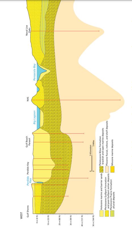
The barrier islands started forming 4500–5400 years ago. On the north side of the islands, the beaches are broad, while on the south side, the beaches include 2 m high dunes on average, but with some reaching 6 m. The white quartz sands originated from the Appalachian Mountains. The surface geology consists mainly of Holocene marine, beach and dune sands. On Santa Rosa Island, these lie unconformably on Pleistocene formations deposited during the Sangamonian Marine Isotope Stage 5, when the sea level was 3 – above the present level. This includes the Gulfport Formation, a barrier complex with shallow nearshore, beach and dune sands, the Prairie Formation, deposited in nearshore marine and estuarine-lagoonal brackish environments, and the Biloxi Formation, consisting of floodplain alluvial deposits. Below these formations are the Pliocene Pensacola Clay, the Oligocene Tampa Member of the Arcadia Formation, and the Oligocene Chickasawhay Limestone. On Horn Island, the Holocene deposits overlay Miocene formations that includes the Pascagoula Formation, consisting of fluvial, estuarine, and nearshore marine (undifferentiated) deposits, the Hattiesburg Formation, consisting of fluvial, estuarine, and nearshore marine (undifferentiated) deposits, and the Catahoula Formation.
Climate
| Gulf Islands National Seashore | 52| 55| 3.2 | 48| 55| 9 | 59| 66| 5.2 | 68| 73| 9 | 72| 81| 4.7 | 75| 81| 7.4 | 77| 81| 12 | 75| 82| 7.8 | 75| 81| 6.9 | 66| 73| 2.8 | 63| 66| 3.3 | 57| 63| 5.4
References
References
- "Annual Park Ranking Report for Recreation Visits in: 2023". National Park Service.
- Robinson, Kevin. "Perdido Keys?! Hurricane Sally cuts eastern tip of barrier island into three sections".
- "Gulf Islands National Seashore {{!}} Florida Smart".
- (2019). "Gulf Islands National Seashore Geologic Resources Inventory Report Natural Resource Report NPS/NRSS/GRD/NRR—2019/1986". U.S. Department of the Interior, National Park Service.
- "NASA Earth Observations Data Set Index". NASA.
This article was imported from Wikipedia and is available under the Creative Commons Attribution-ShareAlike 4.0 License. Content has been adapted to SurfDoc format. Original contributors can be found on the article history page.
Ask Mako anything about Gulf Islands National Seashore — get instant answers, deeper analysis, and related topics.
Research with MakoFree with your Surf account
Create a free account to save articles, ask Mako questions, and organize your research.
Sign up freeThis content may have been generated or modified by AI. CloudSurf Software LLC is not responsible for the accuracy, completeness, or reliability of AI-generated content. Always verify important information from primary sources.
Report