From Surf Wiki (app.surf) — the open knowledge base
Green Mountain National Forest
National Forest in Vermont, US
National Forest in Vermont, US
| Field | Value |
|---|---|
| name | Green Mountain National Forest |
| photo | Hapgood Pond - Flickr - USDAgov.jpg |
| photo_caption | Green Mountain National Forest in October 2011 |
| map | USA#Vermont |
| relief | 1 |
| map_caption | Location in the United States##Location in Vermont |
| mapframe | yes |
| mapframe-zoom | 7 |
| mapframe-wikidata | yes |
| location | Vermont, United States |
| nearest_city | Rutland |
| coordinates | |
| area_acre | 399151 |
| area_ref | federal |
| 421889 acre other | |
| established | April 25, 1932 |
| governing_body | U.S. Forest Service |
| website | Green Mountain & Finger Lakes National Forests |
| mapframe-zoom = 7 | mapframe-wikidata = yes 421889 acre other
Green Mountain National Forest is a national forest located in Vermont, a temperate broadleaf and mixed forest typical of the New England/Acadian forests ecoregion. The forest supports a variety of wildlife, including beaver, moose, coyote, black bear, white-tailed deer, wild turkey, and ruffed grouse. The forest, being situated in Vermont's Green Mountains, has been referred to as the granite backbone of the state.
Established in 1932 due to uncontrolled overlogging, fire and flooding, the forest originally consisted of 102100 acre; however, only 1842 acre were federally owned, while the remaining 100,258 acre within the national forest boundary were not federally owned or administered. , the forest boundaries included 821040 acre, of which 399151 acre were federally owned and administered. GMNF is one of only two national forest areas in New England, the other area being the White Mountain National Forest in New Hampshire.
In descending order of land area, GMNF is located in parts of Bennington, Addison, Rutland, Windham, Windsor, and Washington counties.
The forest contains three nationally designated trails, including parts of the Appalachian Trail and the Long Trail, as well as the Robert Frost National Recreation Trail. The forest also includes three alpine ski areas, seven Nordic ski areas, and approximately 900 mi of multiple-use trails for hiking, cross country skiing, snowmobiling, horseback riding, and bicycling.
The forest benefited from the American Reinvestment and Recovery Act of 2009. Forest revenue is generated by recreation fees (such as at Mount Snow, Stratton Mountain and Bromley Mountain ski areas) and timber sales. About 42 acres were set aside for forest regeneration in 2009. Planned expenditures include road construction, recreation and heritage, and wildlife management. Projects in the latter category include: land/water modification in support of ruffed grouse, wild turkeys, bear, trout, salmon, Bicknell's thrush, and the plant Jacob's ladder. The emerald ash borer is a threat to Vermont's trees.
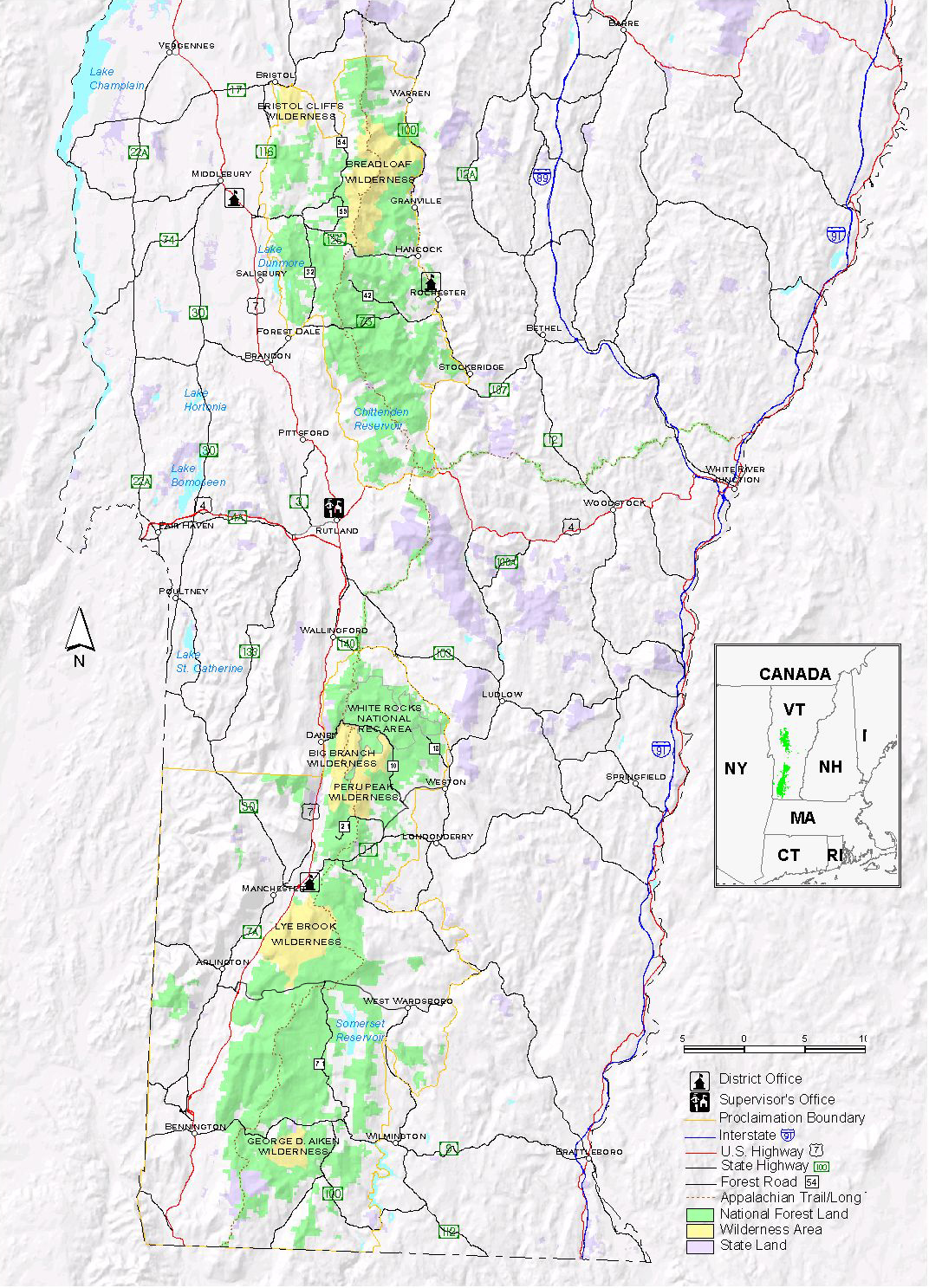
Wilderness areas
There are eight officially designated wilderness areas in the Green Mountain National Forest (from north to south):
| Approximate area | Created by | acres | ha |
|---|---|---|---|
| Bristol Cliffs Wilderness | 3750 acre | Eastern Wilderness Areas Act of 1975 | |
| Breadloaf Wilderness | 24986 acre | Vermont Wilderness Act of 1984 | |
| Joseph Battell Wilderness | 12336 acre | New England Wilderness Act of 2006 | |
| Big Branch Wilderness | 6725 acre | Vermont Wilderness Act of 1984 | |
| Peru Peak Wilderness | 7825 acre | Vermont Wilderness Act of 1984 | |
| Lye Brook Wilderness | 18122 acre | Eastern Wilderness Areas Act of 1975 | |
| Glastenbury Wilderness | 22400 acre | New England Wilderness Act of 2006 | |
| George D. Aiken Wilderness | 4800 acre | Vermont Wilderness Act of 1984 |
Each of these wilderness areas is wholly located in Vermont and is managed by the United States Forest Service as part of the National Wilderness Preservation System. As such, these areas are off-limits to all motorized and mechanical vehicles, including bicycles.
Recreation areas
There are two officially designated recreation areas in the Green Mountain National Forest (from north to south):
| Approximate area | Created by | acres | ha |
|---|---|---|---|
| Moosalamoo National Recreation Area | 15857 acre | New England Wilderness Act of 2006 | |
| White Rocks National Recreation Area | 36400 acre | Vermont Wilderness Act of 1984 |
The latter includes both the Big Branch Wilderness and Peru Peak Wilderness within its boundaries.
References
References
- (January 2012). "Land Areas of the National Forest System". U.S. Forest Service.
- "The National Forests of the United States". ForestHistory.org.
- (2007-04-25). "Green Mountain and Finger Lakes National Forests". Outdoor.com.
- "Staff".
- [https://web.archive.org/web/20150122201215/http://www.fs.usda.gov/main/greenmountain/about-forest "About The Green Mountain & Finger Lakes National Forests"] (archive). ''fs.usda.gov''. [[United States Department of Agriculture]], [[United States Forest Service. Forest Service]].
This article was imported from Wikipedia and is available under the Creative Commons Attribution-ShareAlike 4.0 License. Content has been adapted to SurfDoc format. Original contributors can be found on the article history page.
Ask Mako anything about Green Mountain National Forest — get instant answers, deeper analysis, and related topics.
Research with MakoFree with your Surf account
Create a free account to save articles, ask Mako questions, and organize your research.
Sign up freeThis content may have been generated or modified by AI. CloudSurf Software LLC is not responsible for the accuracy, completeness, or reliability of AI-generated content. Always verify important information from primary sources.
Report