From Surf Wiki (app.surf) — the open knowledge base
Greater Houston
.jpg)
| Field | Value | |||||||
|---|---|---|---|---|---|---|---|---|
| name | Greater Houston | |||||||
| official_name | Houston–Pasadena–The Woodlands, Texas | |||||||
| metropolitan statistical area | ||||||||
| settlement_type | Metropolitan statistical area | |||||||
| image_skyline | {{multiple image | |||||||
| border | infobox | |||||||
| total_width | 290 | |||||||
| image_style | border:1; | |||||||
| perrow | 1/2/1 | |||||||
| image1 | Downtown Houston, TX Skyline - 2018.jpg | |||||||
| image2 | Anadarko, The Woodlands, Texas.jpg | |||||||
| image3 | Sugarland Town Square.jpg | |||||||
| image4 | Galveston, Texas 2022 panorama.jpg | |||||||
| image_caption | From top to bottom, left to right: Houston, The Woodlands, Sugar Land, and Galveston | |||||||
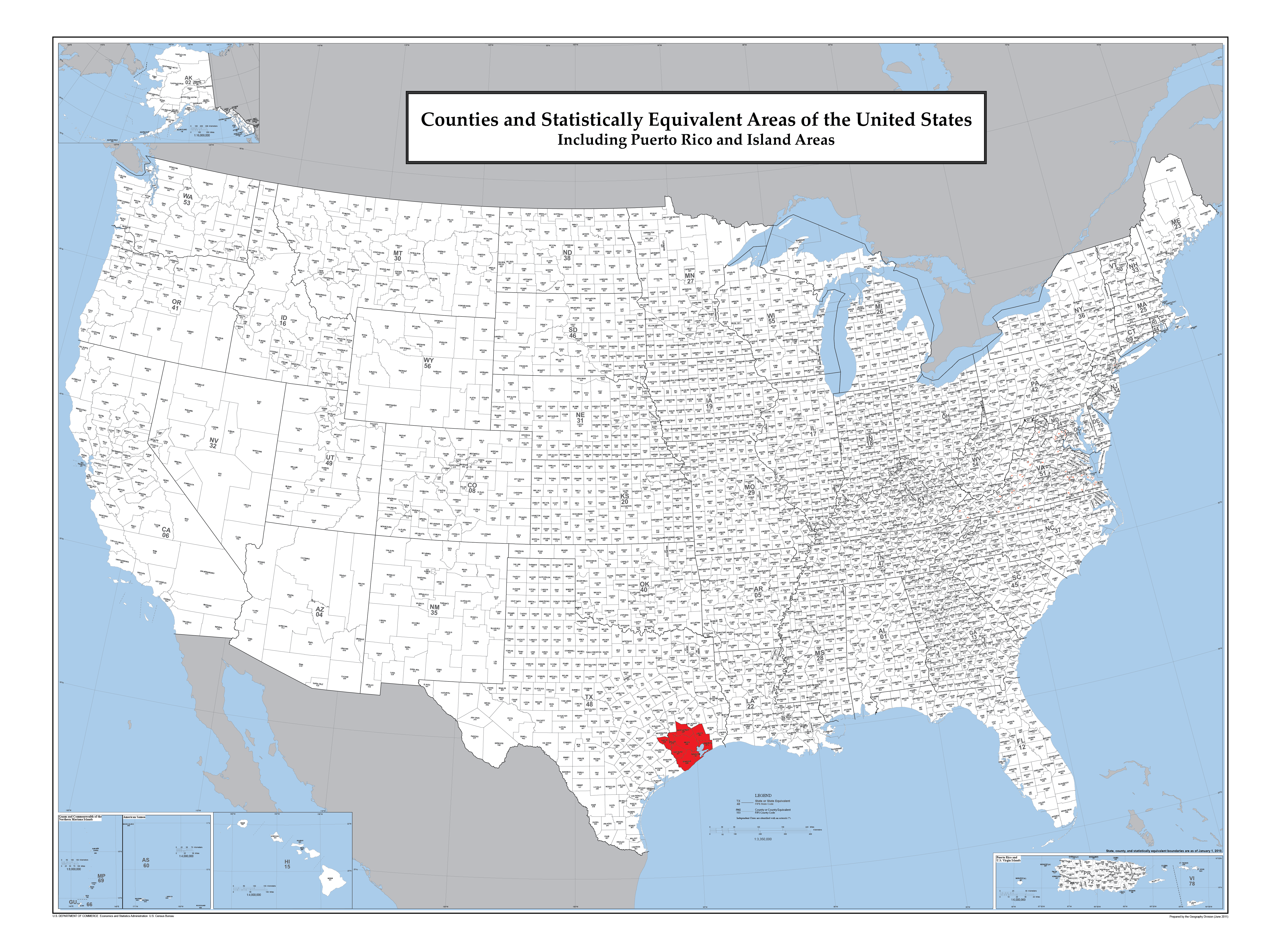
| image_map | {{maplink | frame=yes | zoom=7 | plain=yes | frame-align=center | frame-width=300 | frame-height=300 | frame-coord= |
| type1 | shape | id1=Q108386 | title1=Austin County | stroke-color1=#03202F | stroke-width1=0.5 | fill1=#03202F | fill-opacity1=0.4 | |
| type2 | shape | id2=Q27034 | title2=Brazoria County | stroke-color2=#03202F | stroke-width2=0.5 | fill2=#03202F | fill-opacity2=0.4 | |
| type3 | shape | id3=Q26598 | title3=Chambers County | stroke-color3=#03202F | stroke-width3=0.5 | fill3=#03202F | fill-opacity3=0.4 | |
| type4 | shape | id4=Q26895 | title4=Fort Bend County | stroke-color4=#03202F | stroke-width4=0.5 | fill4=#03202F | fill-opacity4=0.4 | |
| type5 | shape | id5=Q26587 | title5=Galveston County | stroke-color5=#03202F | stroke-width5=0.5 | fill5=#03202F | fill-opacity5=0.4 | |
| type6 | shape | id6=Q26676 | title6=Harris County | stroke-color6=#03202F | stroke-width6=0.5 | fill6=#03202F | fill-opacity6=0.4 | |
| type7 | shape | id7=Q26719 | title7=Liberty County | stroke-color7=#03202F | stroke-width7=0.5 | fill7=#03202F | fill-opacity7=0.4 | |
| type8 | shape | id8=Q26756 | title8=Montgomery County | stroke-color8=#03202F | stroke-width8=0.5 | fill8=#03202F | fill-opacity8=0.4 | |
| type9 | shape | id9=Q111744 | title9=San Jacinto County | stroke-color9=#03202F | stroke-width9=0.5 | fill9=#03202F | fill-opacity9=0.4 | |
| type10 | shape | id10=Q26701 | title10=Waller County | stroke-color10=#03202F | stroke-width10=0.5 | fill10=#03202F | fill-opacity10=0.4 | |
| type11 | shape | id11=Q26883 | title11=Walker County | stroke-color11=#156000 | stroke-width11=0.5 | fill11=#156000 | fill-opacity11=0.4 | |
| type12 | shape | id12=Q483916 | title12=Wharton County | stroke-color12=#BD000A | stroke-width12=0.5 | fill12=#BD000A | fill-opacity12=0.4 | |
| type13 | shape | id13=Q485910 | title13=Matagorda County | stroke-color13=#4B006E | stroke-width13=0.5 | fill13=#4B006E | fill-opacity13=0.4 | |
| type14 | shape | id14=Q156444 | title14=Washington County | stroke-color14=#FF9200 | stroke-width14=0.5 | fill14=#FF9200 | fill-opacity14=0.4 | |
| type15 | shape | id15=Q16555 | title15=City of Houston | stroke-color15=#A71930 | stroke-width15=0.5 | fill15=#A71930 | fill-opacity15=0.5 | |
| map_alt | Map of Greater Houston | |||||||
| map_caption | Interactive Map of Houston–Pasadena, TX CSA | |||||||
| subdivision_type | Country | |||||||
| subdivision_name | [[File:Flag of United States.svg | border | 23px]] United States | |||||
| subdivision_type1 | State | |||||||
| subdivision_name1 | [[File:Flag of Texas.svg | border | 23px]] Texas | |||||
| parts_type | Principal cities | |||||||
| parts_style | list | |||||||
| p1 | Houston | |||||||
| p2 | The Woodlands | |||||||
| p3 | Sugar Land | |||||||
| p4 | Baytown | |||||||
| p5 | Conroe | |||||||
| p6 | Galveston | |||||||
| unit_pref | ||||||||
| area_total_km2 | ||||||||
| area_land_km2 | ||||||||
| area_urban_km2 | 4,299.4 | |||||||
| area_metro_km2 | 26,061 | |||||||
| area_metro_sq_mi | 10,062 | |||||||
| population_as_of | 2020 | |||||||
| population_footnotes | ||||||||
| population_note | MSA/CSA = 2020, Urban = 2010 | |||||||
| population_density_km2 | 1,150.0 | |||||||
| population_density_sq_mi | 2,978.5 | |||||||
| population_urban | 5,853,575(5th) | |||||||
| population_blank1_title | MSA | |||||||
| population_blank1 | 7,796,182 (5th) | |||||||
| population_blank2_title | CSA | |||||||
| population_blank2 | 7,824,643 (9th) | |||||||
| demographics_type2 | GDP | |||||||
| demographics2_footnotes | ||||||||
| demographics2_title1 | MSA | |||||||
| demographics2_info1 | $696.999 billion (2023) | |||||||
| timezone | CST | |||||||
| utc_offset | -6 | |||||||
| timezone_DST | CDT | |||||||
| utc_offset_DST | -5 | |||||||
| elevation_min_m | 0 | |||||||
| elevation_min_ft | 0 | |||||||
| elevation_max_m | 131 | |||||||
| elevation_max_ft | 430 | |||||||
| area_code | 361, 409, 713/281/832/346, 936, 979 | |||||||
| area_code_type | Area codes |
metropolitan statistical area
Greater Houston, designated by the United States Office of Management and Budget as Houston–Pasadena–The Woodlands, is the fifth-most populous metropolitan statistical area in the United States, encompassing ten counties along the Gulf Coast in Southeast Texas. As of 2025, it has a population of 7,824,643.
The region of approximately 10000 sqmi centers on Harris County, the third-most populous county in the U.S., which contains the city of Houston, with a population of more than 2.3 million as of 2010. Greater Houston is part of the Texas Triangle megaregion along with the Dallas–Fort Worth metroplex, Greater Austin, and Greater San Antonio. Greater Houston also serves as a major anchor and economic hub for the Gulf Coast. Its Port of Houston is the largest port in the United States and the 16th-largest in the world.
Greater Houston has historically been among the fastest-growing metropolitan areas in the United States; it was the fastest-growing in absolute terms during the 2013–2014 census year, adding 156,371 people. The area grew 25.2%, adding over 950,000 people, between 1990 and 2000 in comparison to a 13.2% increase in the national population over the same period. Between 2000 and 2007, the area added over 910,000 people. The Greater Houston Partnership projected the metropolitan area would add between 4.1 and 8.3 million new residents between 2010 and 2050.
Greater Houston has the seventh-highest metropolitan-area gross domestic product in the United States, valued at $551 billion in 2023. A major trade center anchored by the Port of Houston, the region has the highest trade export value of all metropolitan areas, at over $180 billion in 2024, accounting for 9% of all U.S. exports. As of 2024, Greater Houston is home to the headquarters of 24 Fortune 500 companies, ranking third among all metropolitan statistical areas.{{Cite web|title=Fortune 500 Companies
Geography
According to the City of Houston, the Houston–Pasadena–The Woodlands metropolitan statistical area has a total area of 10,062 square miles (26,060 km2), which is slightly smaller than the U.S. state of Massachusetts and slightly larger than Maryland. The U.S. Office of Management and Budget combines the Houston–Pasadena–The Woodlands metropolis with four micropolitan statistical areas (Bay City, Brenham, El Campo, and Huntsville) to form the Houston–Pasadena, TX combined statistical area.
The metropolitan area is located in the Gulf Coastal Plains biome, and its vegetation is classified as temperate grassland. Much of the urbanized area was built on forested land, marshes, swamp, or prairie, remnants of which can still be seen in surrounding areas. Of particular note is the Katy Prairie to the west, the Big Thicket to the northeast, and the Galveston Bay ecosystem to the south. Additionally, the metropolitan region is crossed by a number of creeks and bayous, which provide essential drainage during rainfall events; some of the most notable waterways include Buffalo Bayou (upon which Houston was founded), White Oak Bayou, Brays Bayou, Spring Creek, and the San Jacinto River. The upper drainage basin of Buffalo Bayou is impounded by two large flood control reservoirs, Barker Reservoir and Addicks Reservoir, which provide a combined 400,000 acre-ft of storage during large rainfall events and cover a total land area of 26100 acre. Greater Houston's flat topography, susceptibility to high-intensity rainfall events, high level of impervious surface, and inadequately-sized natural drainage channels make it particularly susceptible to catastrophic flooding events.
Geology
Underpinning Greater Houston's land surface are unconsolidated clays, clay shales, and poorly cemented sands up to several miles deep. The region's geology developed from stream deposits formed from the erosion of the Rocky Mountains. These sediments consist of a series of sands and clays deposited on decaying organic matter that, over time, transformed into oil and natural gas. Beneath these tiers is a water-deposited layer of halite, a rock salt. The porous layers were compressed over time and forced upward. As it pushed upward, the salt dragged surrounding sediments into dome shapes, often trapping oil and gas that seeped from the surrounding porous sands. This thick, rich soil also provides a good environment for rice farming in suburban outskirts into which the city of Houston continues to grow near Katy. Evidence of past rice farming is even still evident in developed areas as an abundance of rich, dark, loamy topsoil exists.
The Greater Houston region is generally earthquake-free. While the city of Houston contains over 150 to 300 active surface faults with an aggregate length of up to 310 mile, the clay below the surface precludes the buildup of friction that produces ground-shaking in earthquakes. These faults generally move at a smooth rate in what is termed "fault creep".
Climate
List of hurricanes
A number of tropical storms and hurricanes have hit the metropolitan area, including:
- 1900 Galveston Hurricane, which devastated Galveston and was the deadliest natural disaster in United States history, killing between 8,000 and 12,000.
- Hurricane Carla (1961), which was the most recent Category 4 hurricane to strike Texas until Harvey in 2017.
- Hurricane Alicia (1983), which struck the area as a Category 3, and was at the time, the costliest Atlantic hurricane.
- Tropical Storm Allison (2001), until Harvey, which brought the worst flooding in Houston history and was the first tropical storm to be retired.
- Hurricane Rita (2005), which triggered one of the largest evacuations in United States history in the wake of Hurricane Katrina.
- Hurricane Ike (2008), which brought devastating storm surge to the coast and wind damage into the city.
- Hurricane Harvey (2017), which brought devastating flooding that resulted in excess of $100 billion in damages to Southeast Texas.
- Tropical Storm Imelda (2019) caused widespread flooding around Houston and surrounding areas.
- Hurricane Nicholas (2021), did moderate damage, and brought wind and rain to the area.
- Hurricane Beryl (2024), brought strong winds and significant rainfall, causing devastating damage in Houston. | Dec record low F = 9 | Nov record low F = 25 | Oct record low F = 33 | Sep record low F = 50 | Aug record low F = 66 | Jul record low F = 64 | Jun record low F = 56 | May record low F = 44 | Apr record low F = 36 | Feb record low F = 14 | Mar record low F = 22 | Jan record low F = 10 | Dec record high F = 84 | Apr record high F = 94 | Nov record high F = 90 | Oct record high F = 96 | Sep record high F = 108 | Aug record high F = 106 | Jul record high F = 104 | Jun record high F = 105 | May record high F = 100 | Mar record high F = 96 | Feb record high F = 87 | Jan record high F = 85
Metropolitan communities

Counties
As defined by the U.S. Office of Management and Budget, the metropolitan area of Houston–Pasadena–The Woodlands encompasses ten counties in Southeast Texas. They are listed below:
- Austin County
- Brazoria County
- Chambers County
- Fort Bend County
- Galveston County
- Harris County
- Liberty County
- Montgomery County
- San Jacinto County
- Waller County
Communities
Main article: List of cities and towns in Greater Houston
Eight principal communities are designated within the Greater Houston metropolitan area. The Woodlands is a census-designated place; the rest are cities. They are listed below:
- Houston (2,325,502)
- Pasadena (154,193)
- The Woodlands (116,278)
- Sugar Land (118,600)
- Conroe (98,081)
- Baytown (77,024)
- Galveston (50,457)
- Texas City (55,667)
Other communities:
- Pearland (122,149)
- League City (106,244)
- Missouri City (76,500)
- Spring (CDP) (62,569)
Demographics
Greater Houston 2011 estimate }}
| County | 2020 census | 2010 census | Change | Area | Density |
|---|---|---|---|---|---|
| Austin County | 646.51 sqmi | ||||
| Brazoria County | 1357.70 sqmi | ||||
| Chambers County | 597.14 sqmi | ||||
| Fort Bend County | 861.48 sqmi | ||||
| Galveston County | 378.36 sqmi | ||||
| Harris County | 1703.48 sqmi | ||||
| Liberty County | 1158.42 sqmi | ||||
| Montgomery County | 1041.73 sqmi | ||||
| San Jacinto County | 569.24 sqmi | ||||
| Waller County | 513.43 sqmi | ||||
| Total | 8258.25 sqmi |

Numerically, Greater Houston is the second fastest growing metropolitan area in the U.S. There were a total of 7,122,240 residents within the Greater Houston metropolitan area as of 2020, according to the United States Census Bureau. In 2010, Greater Houston had 5,920,416 residents and in 2000, it had a population of 4,177,646. Another 2010 estimate determined the population increased to 5,920,487. Of the population an estimated 575,000 were undocumented immigrants according to 2014 estimates.
In 2020, Greater Houston's racial makeup was 41% White (non-Hispanic white 34%), 20% Black and African American, 8% Asian and 3% from two or more races; additionally, 37% of the metropolitan population were Hispanic and Latino Americans of any race. Among its metropolitan population, roughly 23.4% were foreign-born. The largest foreign-born population came from Latin America, followed by Asia, Africa, Europe and other parts of North America. The metropolitan statistical area was classified as one of the largest regions where the three largest minority groups were highly represented. In 2018, its racial makeup had an estimated 35.5% Anglo American, 20% Black and African American, 7.6% Asian American and 2.1% other races; approximately 37.6% were Hispanic or Latino American of any race. Nearly one in four Greater Houstonians were foreign-born in 2018 and a quarter of all refugees settled in Texas lived in the region.
According to the 2019 American Community Survey, the median household income was $69,193 and the per capita income was $35,190. Roughly 13% of the metropolis lived at or below the poverty line. As of 2011, Greater Houston has four of Texas's 10 wealthiest communities, which include the wealthiest community, Hunters Creek Village, the fourth-wealthiest community, Bunker Hill Village, the fifth-wealthiest community, West University Place, and the sixth-wealthiest community, Piney Point Village.

Greater Houston's religious community is predominantly Christian and the second-largest metropolitan area that identifies with the religion in Texas after Dallas–Fort Worth (73%). In 2012, the city of Houston proper ranked the ninth most religious city in the U.S.
.jpg)
Within the Greater Houston metropolitan area, the Catholic Church is the largest single Christian denomination as of a 2014 study by the Pew Research Center. Catholics in Houston are primarily served by the Roman Catholic Archdiocese of Galveston–Houston. Following, the body of Evangelical Protestantism was the second largest according to this study; Baptists dominated the Evangelical Protestant demographic. Mainline Protestantism, led by Methodists, was the third largest Christian group.
In a separate study by the Association of Religion Data Archives in 2020, the Catholic Church numbered 1,299,901 for the metropolitan area; by 2020, the second-largest single Christian denomination (Southern Baptists) numbered 800,688; following, non-denominational Protestant churches represented the third-largest Christian cohort at 666,548.
Altogether, however, Baptists of the Southern Baptist Convention, the American Baptist Association, American Baptist Churches USA, Full Gospel Baptist Church Fellowship, National Baptist Convention USA and National Baptist Convention of America, and the National Missionary Baptist Convention numbered 926,554. Non-denominational Protestants, the Disciples of Christ, Christian Churches and Churches of Christ, and the Churches of Christ numbered 723,603 altogether according to the 2020 study.
Within the Eastern Christian tradition, there were 3,617 Coptic Orthodox Christians, 1,746 Eritrean Orthodox and 850 Ethiopian Orthodox, 6,209 Greek Orthodox, 2,405 Malankara Orthodox Syrians, 641 American Orthodox, and 1,058 Serbian Orthodox in the metropolis.
According to the Pew Research Center's 2014 study, non-Christian religions collectively made up 7% of the religious metropolitan population. The largest non-Christian religion was Judaism. According to the study, 20% of Greater Houston was irreligious and 2% were atheist. The Association of Religion Data Archives 2020 study determined there were 7,061 Conservative Jews and 3,050 Orthodox Jews; there were 11,481 Reform Jews throughout the area. There were an estimated 123,256 Muslims, 51,567 Hindus and Yoga practitioners, and 20,281 Buddhists.
Economy

Among the 10 most populous metropolitan areas in the U.S., Greater Houston ranked first in employment growth rate and second in nominal employment growth. In 2006, the Greater Houston metropolitan area ranked first in Texas and third in the U.S. within the category of "Best Places for Business and Careers" by Forbes.
The Houston–The Woodlands-Sugar Land area's gross metropolitan product (GMP) in 2005 was $308.7 billion, up 5.4% from 2004 in constant dollars—slightly larger than Austria's gross domestic product. By 2012, the GMP had risen to $449 billion, the fourth-largest of any metropolitan area in the United States. Only 26 countries other than the United States had a GDP exceeding Greater Houston's GAP.{{cite web |access-date=October 8, 2013
The area's economic activity is centered in the city of Houston, the county seat of Harris County. Houston is second to New York City in Fortune 500 headquarters. The city has attempted to build a banking industry, but the companies originally started in Houston have since merged with other companies nationwide. Banking, however, is still vital to the metropolitan region.
Galveston Bay and the Buffalo Bayou together form one of the most important shipping hubs in the world. The Port of Houston, the Port of Texas City, and the Port of Galveston are all major seaports located in this Greater Houston area. The area is also one of the leading centers of the energy industry, particularly petroleum processing, and many companies have large operations in this region. The metropolitan area also comprises the largest petrochemical manufacturing area in the world, including for synthetic rubber, insecticides, and fertilizers. The area is also the world's leading center for building oilfield equipment. Greater Houston is also a major center of biomedical research, aeronautics, and high technology.

Much of the metro area's success as a petrochemical complex is enabled by its busy man-made Houston Ship Channel. Because of these economic trades, many residents have moved to the Houston area from other U.S. states, as well as hundreds of countries worldwide. Unlike most places, where high fuel prices are seen as harmful to the economy, they are generally seen as beneficial for Houston, as many are employed in the energy industry. Baytown, Pasadena, La Porte, and Texas City have some of the area's largest petroleum/petrochemical plants, though major operations can be found in Houston, Anahuac, Clute, and other communities. Galveston has the largest cruise-ship terminal in Texas (and the 12th-largest in the world). The island, as well the Clear Lake area, are major recreation and tourism areas in the region.
Houston is home to the Texas Medical Center—the largest medical center in the world. Galveston is home to one of only two national biocontainment laboratories in the United States.
The University of Houston System's annual impact on the Houston-area's economy equates to that of a major corporation: $1.1 billion in new funds attracted annually to the Houston area, $3.13 billion in total economic benefit, and 24,000 local jobs generated. This is in addition to the 12,500 new graduates the UH System produces every year who enter the workforce in Houston and throughout Texas. These degree-holders tend to stay in Houston; after five years, 80.5% of graduates are still living and working in the region.
Sugar Land is home to the second-largest economic activities and fifth-largest city in the metropolitan area. It has the most important economic center in Fort Bend County. The city holds the Imperial Sugar (its namesake), Nalco Champion, and Western Airways headquarters. Engineering firms and other related industries have managed to take the place as an economic engine.
Sports
Major professional teams
| Club | Sport | Founded | League | Venue |
|---|---|---|---|---|
| [[File:John_Mallee_and_Jose_Altuve_May_2014.jpg | 120px]] | |||
| Houston Astros | Baseball | 1962 | MLB | Daikin Park |
| [[File:James_Harden_(30735342912).jpg | 120px]] | |||
| Houston Rockets | Basketball | 1967 | NBA | Toyota Center |
| [[File:Andre_Johnson_2010.jpg | 120px]] | |||
| Houston Texans | Football | 2002 | NFL | NRG Stadium |
| [[File:Minnesota United - Houston Dynamo - TCF Bank Stadium - Minneapolis - MLS (39977875910).jpg | 120px]] | |||
| Houston Dynamo | Men's soccer | 2005 | MLS | Shell Energy Stadium |
| [[File:Allysha Chapman - Defender, Houston Dash (21055004615).jpg | 120px]] | |||
| Houston Dash | Women's soccer | 2014 | NWSL | Shell Energy Stadium |
| [[File:Houston SaberCats vs Old Glory DC.jpg | 120px]] | |||
| Houston SaberCats | Rugby Union | 2018 | MLR | Aveva Stadium |
Minor league and semipro teams
| Club | Sport | Founded | League | Venue |
|---|---|---|---|---|
| Houston Energy | Football | 2001 | WPFL | The Rig |
| Houston Roughnecks | Football | 2018 | XFL | TDECU Stadium |
| Houston Red Storm | Basketball | 2006 | ABA | John H. Reagan HS |
| Sugar Land Space Cowboys | Baseball | 2022 | Pacific Coast League | Constellation Field |
| Houston Dutch Lions | Soccer | 2011 | PDL | HDLFC Soccer Complex |
| Houston Aces | Women's soccer | 2012 | UWS | Carl Lewis Stadium |
| Houston Hotshots | Indoor soccer | 2015 | PASL | TBD |
| Houston Havoc | Ultimate | 2023 | UFA | Aveva Stadium |
College sports (Division I)
Greater Houston is home to five NCAA Division I programs, with four located within Houston proper. The University of Houston and Rice University play in Division I-A (FBS). The University of Houston plays in the Big 12 Conference, while Rice belongs to the American Athletic Conference. Both schools were once part of the Southwest Conference. Texas Southern University and Prairie View A&M University, which are members of the Southwestern Athletic Conference, plays in Division I-AA (FCS). Houston Christian University (formerly Houston Baptist University) currently plays in Division I (FCS), mainly in the Southland Conference. Rice and Houston Christian are widely noted for their student-athlete graduation rates, which number at 91% for Rice (tied for highest in the nation according to a 2002 Sports Illustrated issue on best college sports programs) and 80% for HBU.
| School | Founded | Nickname | Conference |
|---|---|---|---|
| [[File:2019 State Fair Classic 32 (Prairie View on offense).jpg | 120px]] | ||
| Prairie View A&M University | 1876 | Prairie View A&M Panthers | Southwestern Athletic Conference |
| [[File:College football - Rice Owls vs Texas Longhorns.jpg | 120px]] | ||
| Rice University | 1912 | Rice Owls | Conference USA |
| [[File:SouthernvsTSU101919-29 (48969534107).jpg | 120px]] | ||
| Texas Southern University | 1927 | Texas Southern Tigers | Southwestern Athletic Conference |
| [[File:Grant Stuard - Houston Cougars football vs. Cincinnati Bearcats.jpg | 120px]] | ||
| University of Houston | 1927 | Houston Cougars | Big 12 Conference |
| [[File:HBU Basketball CIMG8372.JPG | 120px]] | ||
| Houston Christian University | 1960 | Houston Christian Huskies | Southland Conference |
Events
Houston is or has been home to various nationally known sporting events. The most notable is the Houston Livestock Show and Rodeo, which is the world's largest livestock exhibition and rodeo event. Other events of importance on greater Houston include the Shell Houston Open (a PGA Tour event), the U.S. Men's Clay Court Championships (ATP tour), the Houston Marathon, and the Texas Bowl college football bowl game. From 1959 to 1987, Houston hosted the Bluebonnet Bowl. Houston has also played host to three Super Bowls (VIII, XXXVIII, LI), the 1968, 1986, and 2004 MLB All-Star Games, the 2022, 2021, 2019, 2017, 2005 World Series, and the 1989, 2006, 2013 NBA All-Star Games. Houston has also played host to various high school and college sporting events, including the Big 12 Championship Game and hosted the 2011 NCAA Men's Final Four, 2010 NCAA Men's Regional Finals, and 2010 MLS All-Star Game. Houston has held two WrestleMania events, WrestleMania X-Seven and WrestleMania XXV, which is considered the biggest pro-wrestling event of the year, seen as the Super Bowl of pro-wrestling. Houston was also considered a candidate for the 2012 and 2016 Olympic Games.
Higher education

Several private institutions of higher learning—ranging from liberal arts colleges to a nationally recognized Tier One research university—are located within the metropolitan area. The University of St. Thomas is the only Catholic institution of higher education in Houston. Houston Christian University, located in the Sharpstown area, was founded in 1960. Rice University is one of the leading teaching and research universities of the United States and consistently ranks among the nation's top 20 universities by U.S. News & World Report.
Three community college districts exist with campuses in and around Houston. The Houston Community College System serves most of Houston. The northwestern through northeastern parts of the metropolitan area are served by various campuses of the Lone Star College System, while the southeastern portion of the city and some surrounding areas are served by San Jacinto College.
Eastern portions of the area and small sections of the city are served by Lee College. Portions of Fort Bend County are served by Wharton County Junior College. Portions of Galveston County are served by College of the Mainland and Galveston College. Portions of Brazoria County are served by Alvin Community College and Brazosport College. Blinn College serves portions of Austin County. The Houston Community College and Lone Star College systems are within the 10 largest institutions of higher learning in the United States.
Politics
Politically, the Greater Houston area has historically been divided between areas of strength of the Republican and Democratic parties.
Democrats are also stronger in the more liberal Neartown area, which is home to a large artist and LGBT community, and Alief, which houses a sizable Asian American population. In 2008, almost every county in the region voted for Republican John McCain; only Harris County was won by Democratic candidate Barack Obama, by a small margin (51%–49%). Galveston has long been a staunch Democratic stronghold, with the most active Democratic county establishment in the state.
United States Congress
| Senators | Name | Party | First elected | Level | Representatives | Name | Party | First elected | Area(s) of Greater Houston represented |
|---|---|---|---|---|---|---|---|---|---|
| Senate Class 1 | Ted Cruz | Republican | 2012 | Junior Senator | |||||
| Senate Class 2 | John Cornyn | Republican | 2002 | Senior Senator | |||||
| District 2 | Dan Crenshaw | Republican | 2018 | Kingwood portion of Houston, Spring, northeast Harris County (including Baytown, Humble and La Porte), western and southern Liberty County | |||||
| District 7 | Lizzie Pannill Fletcher | Democratic | 2018 | West Houston, Memorial Villages, Bellaire, West University Place, west and northwest Harris County | |||||
| District 8 | Morgan Luttrell | Republican | 2022 | Polk and San Jacinto counties; northern Montgomery County; southern Walker County; western Harris County | |||||
| District 9 | Al Green | Democratic | 2004 | Alief, Southwest Houston, Houston's Southside, portions of Fort Bend County (Mission Bend, eastern portion of Stafford, northern and eastern portions of Missouri City, county's entire share of Houston) | |||||
| District 10 | Michael McCaul | Republican | 2004 | Northwest Harris County; Austin and Waller counties; most of the Greater Katy area | |||||
| District 18 | Vacant | N/A | N/A | Downtown Houston, Bush IAH, northwest and northeast Houston, inner portions of Houston's Southside | |||||
| District 22 | Troy Nehls | Republican | 2020 | most of Fort Bend County (Sugar Land, Rosenberg, the southern portion of Greater Katy, plus western and southern portions of Missouri City), northern Brazoria County (including Pearland), portions of Galveston County (La Marque), southern and central Pasadena, Deer Park, parts of Clear Lake City | |||||
| District 29 | Sylvia Garcia | Democratic | 2018 | East Houston, northern Pasadena, Galena Park, Channelview (all Harris County) | |||||
| District 36 | Brian Babin | Republican | 2014 | Southeastern and eastern parts of Harris County (including the Lyndon B. Johnson Space Center) |
Texas Legislature
Texas Senate
| District | Name | Party | First elected | Area(s) of Greater Houston represented |
|---|---|---|---|---|
| 3 | Robert Nichols | Republican | 2006 | |
| 4 | Brandon Creighton | Republican | 2014 | |
| 5 | Charles Schwertner | Republican | 2012 | |
| 6 | Carol Alvarado | Democratic | 2018 | |
| 7 | Paul Bettencourt | Republican | 2015 | |
| 11 | Larry Taylor | Republican | 2013 | |
| 13 | Borris Miles | Democratic | 2017 | |
| 15 | Molly Cook | Democratic | 2024 | |
| 17 | Joan Huffman | Republican | 2008 | |
| 18 | Lois Kolkhorst | Republican | 2015 |
Texas House of Representatives
| District | Name | Party | First elected | Area(s) of Greater Houston represented |
|---|---|---|---|---|
| 3 | Cecil Bell Jr. | Republican | 2012 | |
| 15 | Steve Toth | Republican | 2018 | |
| 16 | Will Metcalf | Republican | 2014 | |
| 18 | Janis Holt | Republican | 2024 | |
| 23 | Terri Leo-Wilson | Republican | 2022 | |
| 24 | Greg Bonnen | Republican | 2012 | |
| 25 | Cody Vasut | Republican | 2020 | |
| 26 | Matt Morgan | Republican | 2024 | |
| 27 | Ron Reynold | Democratic | 2010 | |
| 28 | Gary Gates | Republican | 2020 | |
| 29 | Jeffrey Barry | Republican | 2024 | |
| 76 | Suleman Lalani | Democratic | 2022 | |
| 85 | Stan Kitzman | Republican | 2022 | |
| 126 | Sam Harless | Republican | 2018 | |
| 127 | Charles Cunningham | Republican | 2022 | |
| 128 | Briscoe Cain | Republican | 2016 | |
| 129 | Dennis Paul | Republican | 2014 | |
| 130 | Tom Oliverson | Republican | 2016 | |
| 131 | Alma Allen | Democratic | 2004 | |
| 132 | Mike Schofield | Republican | 2014 | |
| 133 | Mano DeAyala | Republican | 2022 | |
| 134 | Ann Johnson | Democratic | 2020 | |
| 135 | Jon Rosenthal | Democratic | 2018 | |
| 137 | Gene Wu | Democratic | 2012 | |
| 138 | Lacey Hull | Republican | 2020 | |
| 139 | Charlene Ward Johnson | Democratic | 2024 | |
| 140 | Armando Walle | Democratic | 2008 | |
| 141 | Senfronia Thompson | Democratic | 1972 | |
| 142 | Harold Dutton Jr. | Democratic | 1984 | |
| 143 | Ana Hernandez | Democratic | 2005 | |
| ; | 144 | Mary Ann Perez | Democratic | 2017 |
| 145 | Christina Morales | Democratic | 2018 | |
| 146 | Lauren Ashley Simmons | Democratic | 2024 | |
| 147 | Jolanda Jones | Democratic | 2022 | |
| 148 | Penny Morales Shaw | Democratic | 2020 | |
| 149 | Hubert Vo | Democratic | 2004 | |
| 150 | Valoree Swanson | Republican | 2016 |
| Year | DEM | GOP | Others |
|---|---|---|---|
| 2024 | 45.1% 1,305,209 | 53.4% 1,544,755 | 1.4% 41,837 |
| 2020 | 49.8% 1,330,116 | 48.8% 1,302,436 | 1.4% 36,931 |
| 2016 | 47.4% 991,171 | 48.4% 1,012,507 | 4.3% 89,327 |
| 2012 | 43.6% 811,798 | 55.2% 1,027,708 | 1.3% 23,530 |
| 2008 | 45.6% 823,491 | 53.6% 967,233 | 0.7% 13,508 |
| 2004 | 41.0% 664,498 | 58.4% 947,144 | 0.7% 10,635 |
| 2000 | 40.0% 571,677 | 57.4% 818,742 | 2.6% 37,095 |
| 1996 | 43.2% 524,035 | 50.6% 614,174 | 6.2% 75,696 |
| 1992 | 36.9% 485,614 | 43.1% 566,917 | 19.9% 261,767 |
| 1988 | 41.9% 464,661 | 57.2% 633,685 | 0.9% 10,405 |
| 1984 | 37.5% 435,551 | 62.2% 721,871 | 0.3% 3,141 |
| 1980 | 38.5% 361,817 | 57.6% 541,762 | 3.9% 37,116 |
| 1976 | 48.1% 421,617 | 51.0% 446,420 | 0.9% 7,603 |
| 1972 | 36.6% 265,828 | 62.9% 457,043 | 0.5% 3,466 |
| 1968 | 39.4% 236,209 | 40.8% 244,601 | 19.8% 118,699 |
| 1964 | 61.1% 297,393 | 38.7% 188,335 | 0.2% 1,099 |
| 1960 | 47.5% 198,877 | 50.1% 209,747 | 2.4% 10,122 |
Culture
Houston's concentration of consular offices ranks third in the nation and first in the South, with 90 countries represented. The city of Houston is considered a major center of Black and African American political power, education, economic prosperity, and culture, often called the new black mecca after Atlanta, Georgia. Houston and its metropolitan area also has a sizable Hispanic and Latin American community. CNN/Money and Money magazine have recognized cities in the Greater Houston area the past three years as part of its "100 Best Places to Live in the United States". In 2005, Sugar Land, southwest of Houston in northeast Fort Bend County, was ranked 46th in the nation, and one of only three Texas cities among the Top 100. In 2006, the magazine recognized Sugar Land again, this time as the third-best city on its list. Also making the 2006 list were League City (65th) in northern Galveston County and The Woodlands (73rd) in southern Montgomery County. In 2007, another Houston suburb, Friendswood, made the list ranked 51st in the nation. The 2006 list only includes cities with at least 50,000 residents, and the 2007 list contains only cities with less than 50,000 residents.
Greater Houston is widely noted for its ethnic diversity and strong international community. In its 2010 publication "Urban Elite", A.T. Kearney added the city to their list of the 65 most important world cities and ranks Houston 35th, as "...a magnet for a diverse population and business services...". The Globalization and World Cities Study Group and Network ranks Houston as a Beta- World City, "an important world city instrumental to linking their region or state to the world economy."
Media
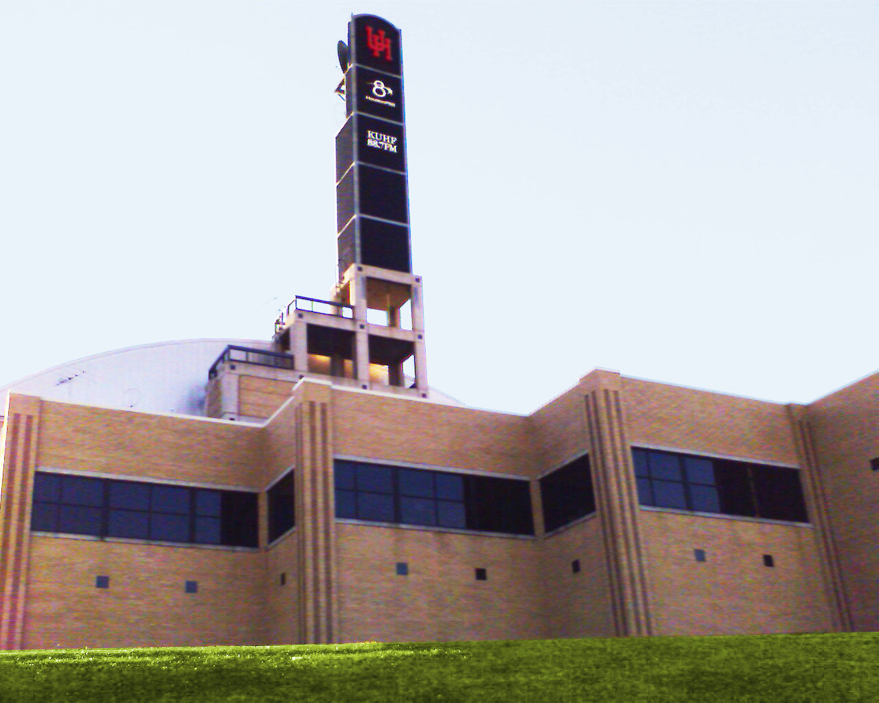
Houston–The Woodlands–Sugar Land metropolitan area is served by a public television station and one public radio station. KUHT (HoustonPBS) is a PBS member station and is the first public television station in the United States. Houston Public Radio is listener-funded radio and comprises one NPR member station, KUHF (KUHF News). The University of Houston System owns and holds broadcasting licenses to KUHT and KUHF. The stations broadcast from the Melcher Center for Public Broadcasting, located on the campus of the University of Houston. The metropolitan area is also served by ABC 13 (KTRK-TV) and Fox 26 (KRIV-TV), owned-and-operated stations of ABC and Fox, and NBC and CBS affiliates KPRC 2 and KHOU 11.
The Houston area is served by the Houston Chronicle, its only major daily newspaper with wide distribution. The Hearst Corporation, which owns and operates the Houston Chronicle, bought the assets of the Houston Post—its long-time rival and main competition—when Houston Post ceased operations in 1995. The Houston Post was owned by the family of former Lieutenant Governor Bill Hobby of Houston. The only other major publication to serve the city is the Houston Press—a free alternative weekly with a weekly readership of more than 300,000.
The Galveston County Daily News, founded in 1842, is that city's primary newspaper and the oldest continuously printed newspaper in Texas. It currently serves as the newspaper of record for Galveston, as well as Galveston County. Radio station KGBC, on air since 1947, has also served as a local media outlet.
Transportation
Highways
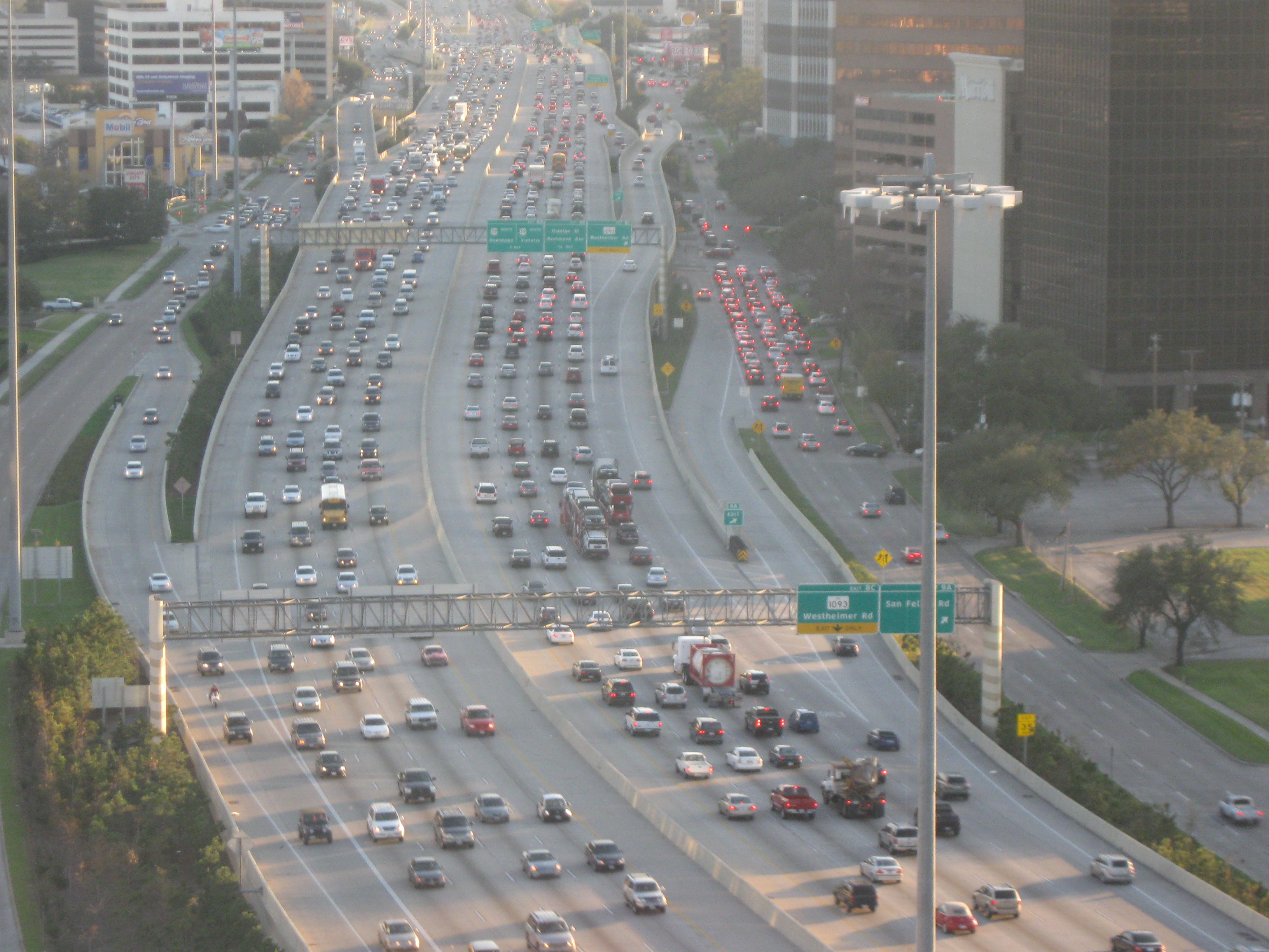
Greater Houston's freeway system includes 3448 mi of freeways and expressways in the 7 counties that constitute TxDOT's Houston District, which are Brazoria, Fort Bend, Galveston, Harris, Montgomery, and Waller Counties. The State of Texas plans to spend $65 billion on Houston area highways by 2025. Houston freeways are heavily traveled and often under construction to meet the demands of continuing growth.
The Greater Houston area has a hub-and-spoke freeway structure with multiple loops. The innermost is Interstate 610, forming a roughly 42 mi-circumference loop around downtown. The nearly square Loop 610 is quartered into "North Loop", "South Loop", "West Loop", and "East Loop". The roads of Beltway 8 and their freeway core, the Sam Houston Tollway, are the next loop, at a diameter around 83 mi. A planned highway project, State Highway 99 (the Grand Parkway), will form the third loop outside of Houston. Currently, a completed portion of State Highway 99 runs clockwise from I-69/US 59 in Sugar Land, southwest of Houston to State Highway 146 in Baytown, east of Houston and was completed in 2022. When completed in the future, I-69 will start at the Mexico–US border, go through the Greater Houston area, and continue on to Michigan at the Canada–US border. All of I-69 has been completed in the Greater Houston area and is co-signed with U.S. Highway 59. Interstate 45, which starts at State Highway 75 in Dallas provides transport from Houston to Dallas.
Mass transit
![]]{{See also](https://upload.wikimedia.org/wikipedia/commons/9/97/METRORail_4.jpg)
The Metropolitan Transit Authority of Harris County (METRO) provides public transportation in the form of buses, light rail, high-occupancy vehicle (HOV) lanes, and paratransit to fifteen municipalities throughout the Greater Houston area and parts of unincorporated Harris County. As of 2016, METRO's service area covers 1303 mi2 containing a population of 3.6 million.
The Woodlands Express provides a park and ride service for transit between The Woodlands and Houston.
Some areas in east Harris County are served by Harris County Transit.
Airports
Houston's largest airport George Bush Intercontinental Airport, is located in north Houston. It is the second largest hub for United Airlines.
In 2010, Continental Airlines moved its headquarters from downtown Houston to downtown Chicago upon its merger with United Airlines. The southeast of Houston has William P. Hobby Airport, the second-largest commercial passenger airport. Houston's third-largest airport is Ellington Field, which houses several National Guard and Air National Guard units, as well as a United States Coast Guard air station and the Lyndon B. Johnson Space Center's fleet of jets that are used to train astronauts. Sugar Land has the Sugar Land Regional Airport, which is the fourth-largest airport in the metropolitan area. Both Sugar Land Regional and Ellington Field serve as reliever airports for the Houston Airport System.
Intercity rail
Amtrak provides intercity rail service to the Houston station.
Intercity bus
Greyhound Bus Lines operates services from three bus stations in the City of Houston:
- Houston Greyhound Station at 2121 South Main Street
- Americanos U.S. L.L.C. (Houston Southeast) at 7218 Harrisburg Boulevard.
- Agencia Autobuses (Houston Southwest) at 6590 Southwest Freeway In addition, Greyhound operates services from two stops
- Houston Aau
- Houston (Amtrak station) Greyhound also operates services to stops within other cities in the Greater Houston area, including:
- Angleton (at Save Step Food Mart)
- Baytown (at Baytown Travel Express)
- Conroe (at Shell)
- Katy (at Sunmart Texaco)
- Prairie View (at Unco Food Store)
- Rosenberg (at Shell-McDonald's)
Three Megabus stations additionally serve the Houston area:
- Downtown – a parking lot located at 815 Pierce Street across the street from METRO's Downtown Transit Center
- Northwest Houston – a Shell gas station located at 13250 FM 1960
- Katy Mills Mall – at Entrance 5, 5000 Katy Mills Circle
Notes
References
References
- "OMB Bulletin No. 20-01: Revised Delineations of Metropolitan Statistical Areas, Micropolitan Statistical Areas, and Combined Statistical Areas, and Guidance on Uses of the Delineations of These Areas".
- "U.S. Census website". [[United States Census Bureau]].
- "Total Gross Domestic Product for Houston-The Woodlands-Sugar Land, TX (MSA)". [[Federal Reserve Bank of St. Louis]].
- (2023-07-21). "OMB Bulletin No. 23-01".
- (March 25, 2025). "Metropolitan and Micropolitan Statistical Areas Population Totals: 2020-2024". [[United States Census Bureau]], Population Division.
- "Growth Challenges and Opportunities in the Texas Triangle".
- [https://www.census.gov/popest/cities/tables/SUB-EST2009-01.csv] [http://webarchive.loc.gov/all/20101017143254/http%3A//www%2Ecensus%2Egov/popest/cities/tables/SUB%2DEST2009%2D01%2Ecsv Archived copy] at the [[Library_of_Congress]] (October 17, 2010).
- "World Port Rankings 2016".
- (March 26, 2015). "CENSUS: FLORIDA CITY TOPS LIST OF FASTEST-GROWING AREAS". Associated Press.
- [http://recenter.tamu.edu/data/popm00/pcbsa26420.html Houston-Sugar Land-Baytown, TX Metropolitan Statistical Area (CBSA) Population and Components of Change] {{webarchive. link. (January 25, 2009)
- (April 2017). "Metro Houston Population Forecast".
- (December 4, 2024). "Gross Domestic Product by Metropolitan Area, 2023".
- (March 2025). "U.S. Exports by Metropolitan Area, 2024".
- Trulia. "America's Most Diverse Neighborhoods And Metros".
- "Facts Flier".
- (2023-07-21). "OMB Bulletin No. 23-01".
- (August 2009). "2009 Master Plan: Addicks and Barker Reservoirs".
- Vartabedian, Ralph. (2017-08-29). "For years, engineers have warned that Houston was a flood disaster in the making. Why didn't somebody do something?". Los Angeles Times.
- "TSHA {{!}} Rice Culture".
- "USGS Miscellaneous Field Studies Map 1136".
- [http://www.gcags2006.com/ABSTRACTS/abstract.engelkemeir.et al.pdf Mapping Active Faults in the Houston area Using LIDAR]{{dead link. (September 2017)
- [http://www.geotecheng.com/gd_geological_faults_enlarged_map.html Principal Active Faults. Houston Area, Texas] {{webarchive. link. (December 5, 2009 . ''U.S. Department of Agriculture, 1984.'')
- (2008-12-30). "Weather Stats".
- "U.S. Census website". United States Census Bureau.
- [https://www.thewoodlandstownship-tx.gov/DocumentCenter/View/12189/Demographics_123117_FINAL THE WOODLANDS, TEXAS DEMOGRAPHICS] {{Webarchive. link. (November 9, 2018 , The Howard Hughes Corporation, January 1, 2018.)
- (April 11, 2023). "Houston region saw second-largest population surge in U.S. In 2021-2022, census analysis finds".
- Reyes, Kyle Bentle, Jonathon Berlin, Cecilia. (April 18, 2019). "Charts of metro areas that gained and lost the most people and how the Chicago area compares".
- "P2 Hispanic or Latino, and Not Hispanic or Latino by Race".
- "Houston Facts: 2020".
- (2017-02-13). "More Than One Million Undocumented People Live In Houston and Dallas Combined".
- Frey, William H.. (2019-08-29). "Six maps that reveal America's expanding racial diversity".
- "Houston holds some of Texas most wealthiest communities".
- "Religion in America: U.S. Religious Data, Demographics and Statistics".
- (2015-07-29). "Dallas Has the Most Christians".
- Balke, Jeff. (2012-05-29). "Texas Number 14 on List of Most Christian States, Houston Ninth Most Religious Among Cities".
- "Maps and data files for 2020".
- (September 7, 2012). "Facts and Figures – Greater Houston Partnership".
- Badenhausen, Kurt. (May 4, 2006). "Best Places For Business And Careers". Forbes.
- (2013-11-06). "U.S. Bureau of Economic Analysis (BEA)".
- (2025). "Facts and Figures; Greater Houston Partnership".
- (December 7, 2020). "Amazon Announces New Fulfillment Center in Missouri City, TX {{!}} Amazon.com, Inc. – Press Room".
- "Houston Facts: 2020".
- {{Handbook of Texas
- Olien, Roger M.. "Oil and Gas Industry".
- Weisman (2007), p. 132.
- Russo, Gene. (June 18, 2009). "Texas-sized challenge". Nature Publishing Group (a division of Macmillan).
- "Overview of the Port of South Louisiana". Port of South Louisiana.
- (September 2010). "Bay Area Overview". Bay Area Houston Economic Partnership.
- "Houston Texas Medical Center – Greater Houston Partnership".
- "Welcome to Galveston National Laboratory".
- TRESAUGUE, Matthew. (May 17, 2006). "Study suggests UH degrees are crucial economic factor". Houston Chronicle.
- "The Economic Impact of Higher Education on Houston: A Case Study of the University of Houston System". University of Houston System.
- Genessy, Jody. (September 6, 2007). "H-E-L-P! Is it 1-AA, FBS, FCS or LOL".
- (November 21, 2011). "HBU Accepts Invitation to Join Southland Conference".
- Bonnin, Richard. "Carnegie Foundation Gives University of Houston its Highest Classification for Research Success, Elevating UH to Tier One Status". University of Houston.
- (January 21, 2011). "UH achieves Tier One status in research". Houston Business Journal.
- (January 18, 2011). "UH takes big step up to Tier One status". Houston Chronicle.
- Khator, Renu. (October 4, 2011). "State of the University: Fall 2011". University of Houston.
- "Rice University, Best Colleges 2009". U.S. News & World Report.
- "Election maps".
- "County Results - Election Center 2008 - Elections & Politics from CNN.com". CNN.
- "Galveston County Democratic Party".
- "Houston International Protocol Alliance".
- Graves, Earl G. Sr.. (December 8, 2016). "Join us in Houston, America's Next Great Black Business Mecca".
- Haley, John H.. (Summer 1993). "Reviewed Work: ''[[Black Dixie: Afro-Texan History and Culture in Houston]]'' by Howard Beeth, Cary D. Wintz". [[The Georgia Historical Quarterly]].
- Casey, Rick. "[http://www.chron.com/disp/story.mpl/metropolitan/casey/7538687.html City Hall Latino win may end up as a loss instead]," ''[[Houston Chronicle]]''. April 28, 2011. Retrieved on June 6, 2011. "The biggest factor is that while Houston is now about 44 percent Hispanic, only about half are citizens of voting age. Many are not citizens, especially in the Gulfton and Spring Branch areas."
- "Best Places to Live 2006". CNN.
- "The Urban Elite: The A.T. Kearney Global Cities Index 2010".
- (April 13, 2010). "GaWC – The World According to GaWC 2008". Lboro.ac.uk.
- "Houston Press: About Us". Houston Press.
- "The Galveston County Daily News". Galvestondailynews.com.
- Jones, Leigh. (March 10, 2009). "Island radio station making a comeback". The Galveston County Daily News.
- (2016). "Gulf Coast Regionally Coordinated Transportation Plan – 2016 Transportation Resource Inventory Update".
- Partain, Claire. (February 1, 2023). "How to take The Woodlands Express to and from your downtown commute".
- "Houston, TX Train Station (HOS) – Amtrak".
- "Bus Station Locator – Greyhound".
- "Bus Station Locator – Greyhound".
- "Bus Station Locator – Greyhound".
- (September 2017)
- "Bus Station Locator – Greyhound".
- "Bus Station Locator – Greyhound".
- "Bus Station Locator – Greyhound".
- "Bus Station Locator – Greyhound".
- "Bus Station Locator – Greyhound".
- "Bus Station Locator – Greyhound".
This article was imported from Wikipedia and is available under the Creative Commons Attribution-ShareAlike 4.0 License. Content has been adapted to SurfDoc format. Original contributors can be found on the article history page.
Ask Mako anything about Greater Houston — get instant answers, deeper analysis, and related topics.
Research with MakoFree with your Surf account
Create a free account to save articles, ask Mako questions, and organize your research.
Sign up freeThis content may have been generated or modified by AI. CloudSurf Software LLC is not responsible for the accuracy, completeness, or reliability of AI-generated content. Always verify important information from primary sources.
Report