From Surf Wiki (app.surf) — the open knowledge base
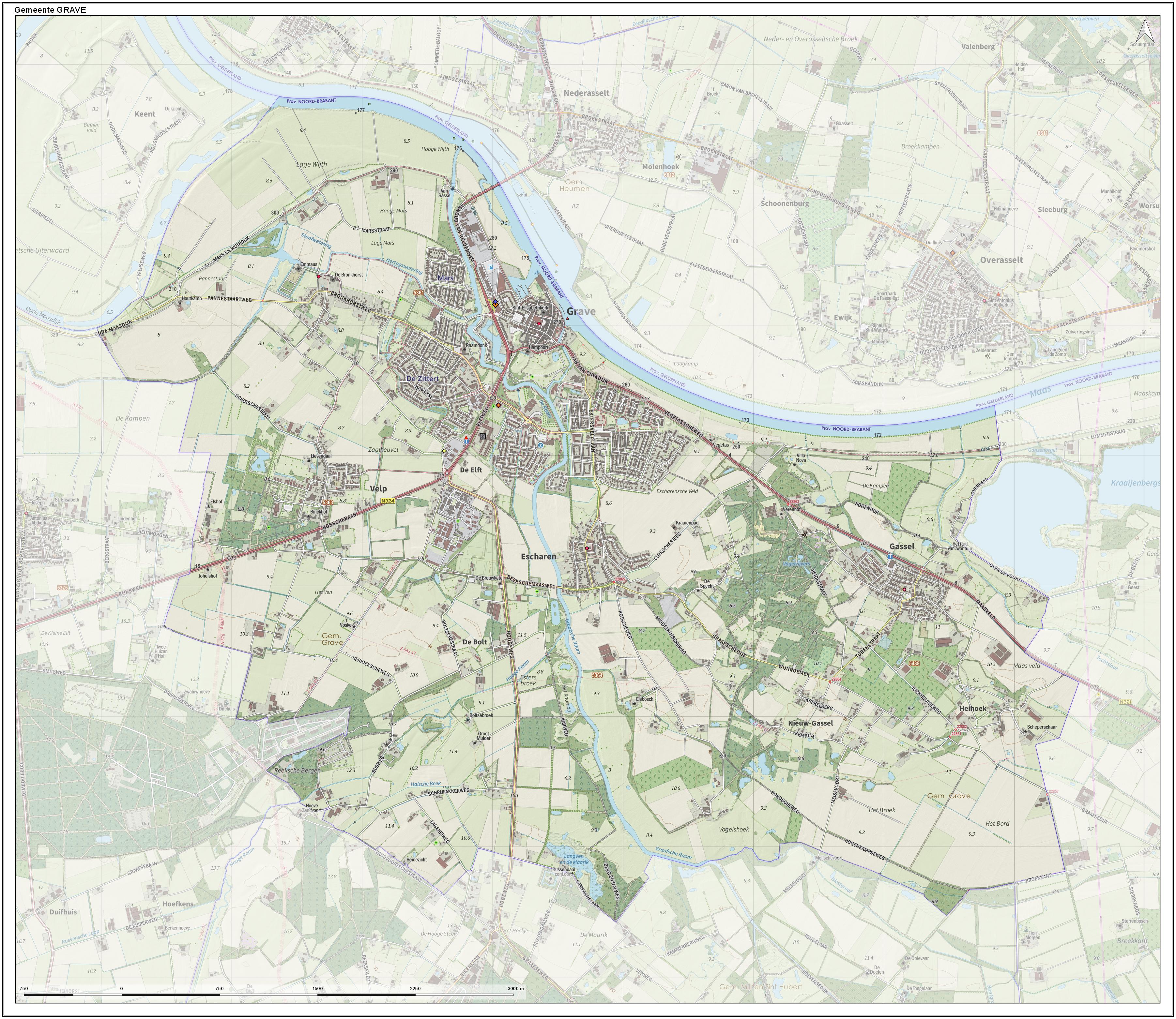
Grave, Netherlands
| Field | Value |
|---|---|
| name | Grave |
| settlement_type | City and former municipality |
| image_skyline | Grave skyline maaskade.jpg |
| image_caption | Grave town centre |
| image_flag | Grave vlag.svg |
| flag_size | 100x67px |
| image_shield | Coat of arms of Grave.svg |
| shield_size | 100x80px |
| image_map | Map - NL - Municipality code 0786 (2009).svg |
| map_alt | Highlighted position of Grave in a municipal map of North Brabant |
| map_caption | Location of the former municipality of Grave in North Brabant |
| pushpin_map | Netherlands North Brabant#Netherlands |
| pushpin_mapsize | 250 |
| pushpin_map_caption | Location in the province of North Brabant in the Netherlands |
| coordinates | |
| subdivision_type | Country |
| subdivision_name | Netherlands |
| subdivision_type1 | Province |
| subdivision_name1 | North Brabant |
| subdivision_type2 | Municipality |
| subdivision_name2 | Land van Cuijk |
| unit_pref | Metric |
| area_footnotes | |
| area_total_km2 | 3.24 |
| elevation_footnotes | |
| elevation_m | 10 |
| population_footnotes | |
| population_total | 8,580 |
| population_as_of | 2021 |
| population_density_km2 | auto |
| timezone | CET |
| utc_offset | +1 |
| timezone_DST | CEST |
| utc_offset_DST | +2 |
| postal_code_type | Postcode |
| postal_code | 5360–5361 |
| area_code_type | Area code |
| area_code | 0486 |
| website |
Grave (; formerly De Graaf) is a city and former municipality in the Dutch province of North Brabant. The former municipality had a population of in . Grave is a member of the Dutch Association of Fortified Cities.
The former municipality included the following towns: Grave (capital), Velp, Escharen and Gassel.
Grave, Boxmeer, Cuijk, Mill en Sint Hubert, and Sint Anthonis merged into the new municipality of Land van Cuijk on 1 January 2022.
History
Grave received city rights in 1233.
The former municipality of Grave was formed in the Napoleonic era (1810) and coincided with the fortified Grave and immediate surroundings. The history of the town was thus linked to that of the place.
This changed in 1942. Then there was a reclassification place where the municipality Grave was expanded with the previously independent municipalities Velp and Escharen. Moreover, in 1994 the neighboring municipality of Beers was abolished and a part thereof, the parish Gassel, was also added to the municipality Grave.
Popular attractions
Near to Grave lies a bridge, now called John S. Thompsonbrug, built in 1929. It is the northern connection to Gelderland, spanning the river Maas. The bridge was one of the key strategic points in Operation Market Garden; the city was liberated at 17 September 1944, suffering very little damage. The bridge was named in 2004 after Lieutenant John S. Thompson of the US Army's 82nd Airborne Division, who commanded the platoon of the 82nd Airborne Division that captured the bridge.
The Hampoort is the old entrance to the city, and it is still largely intact and can be visited.
Notable people
Nobility
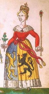
- Mary of Guelders ( in Grave – 1463), the queen consort of Scotland as the wife of King James II of Scotland, served as regent of Scotland from 1460 to 1463
- Adolf, Duke of Guelders (1438 in Grave – 1477) Duke of Guelders & Count of Zutphen 1465–1471
- Charles II, Duke of Guelders (1467 in Grave – 1538) member of the House of Egmond who ruled as Duke of Guelders and Count of Zutphen from 1492 to 1538
- Anna van Egmont (1533 in Grave – 1558) a wealthy Dutch heiress, the first wife of William the Silent, Prince of Orange
- Louise van der Nooth (1630s in Grave – 1654) a maid of honour and favorite of Queen Christina of Sweden
Others
- Johann Weyer (1515 in Grave – 1588) Dutch physician, occultist and demonologist, disciple and follower of Heinrich Cornelius Agrippa
- Charles de Thierry (1793 in Grave – 1864) an adventurer in New Zealand
- Jan Pieter van Suchtelen (1751 in Grave – 1836) general in the Russian army during the Russo-Swedish War (1808–1809)
- Johan Stein (1871 in Grave – 1951) Dutch astronomer and a member of the Society of Jesus
Images
Image:2006-05-17 13.37 Grave, brug over de Maas.JPG|Bridge: John S. Thompsonbrug Image:Grave, straatzicht Brugstraat 2-10 bij Oranjehotel foto1 2010-04-10 11.02.jpg|Houses in centre Image:Grave vistrap inlaat scheepswerf.jpg|Fish ladder and shipyard Image:Grave canal lock.jpg|Canal lock
References
References
- "Postcodetool for 5361CV". Het Waterschapshuis.
- "Kerncijfers wijken en buurten 2021".
This article was imported from Wikipedia and is available under the Creative Commons Attribution-ShareAlike 4.0 License. Content has been adapted to SurfDoc format. Original contributors can be found on the article history page.
Ask Mako anything about Grave, Netherlands — get instant answers, deeper analysis, and related topics.
Research with MakoFree with your Surf account
Create a free account to save articles, ask Mako questions, and organize your research.
Sign up freeThis content may have been generated or modified by AI. CloudSurf Software LLC is not responsible for the accuracy, completeness, or reliability of AI-generated content. Always verify important information from primary sources.
Report