From Surf Wiki (app.surf) — the open knowledge base
Goulais River
River in Ontario, Canada
River in Ontario, Canada
| Field | Value |
|---|---|
| name | Goulais River |
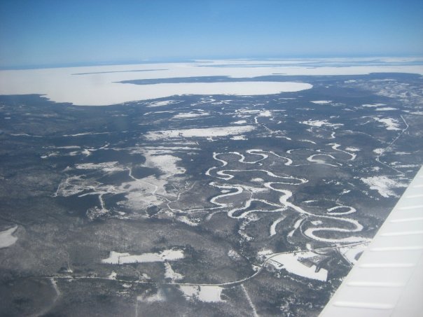
| image | Goulais River.JPG |
| pushpin_map | Ontario |
| subdivision_name1 | Canada |
| subdivision_type2 | Province |
| subdivision_name2 | Ontario |
| subdivision_type3 | District |
| subdivision_name3 | Algoma |
| length | 70 km |
| discharge1_location | Kirby's Corner |
| discharge1_avg | 31.9 m3/s |
| mouth | Goulais Bay |
| mouth_location | Goulais and District |
| mouth_coordinates | |
| mouth_elevation | 183 m |
| basin_size |
The Goulais River (Pronounced: goo-lee) is a river in northern Ontario, Canada, which rises in the Algoma highlands and empties into Goulais Bay on eastern Lake Superior near Sault Ste. Marie, Ontario. It is one of the largest tributaries on the eastern lake, draining an area of approximately 2000 km2.
The river and its tributaries were used to transport logs to local sawmills during the second half of the 19th century. The Algoma Central Railway travels up the river valley on its way to the Agawa canyon.
At one time, the river was an important spawning area for lake sturgeon. However, logging operations, fishing and the installation of an electric barrier to prevent sea lampreys from travelling upstream (removed in 1960) have reduced sturgeon activity in the river.
The river is used for recreational canoeing, kayaking, and swimming, and the headwaters and parts of the river have been protected by the Goulais River Provincial Park.
The river's name is thought to come from the French word goulet or "narrow passage", which is also the source of the English words "gully" and "gullet". The French called the area at the river's mouth Anse de la pêche or "Fish Inlet".
The Goulais River is a popular yellow pickerel fishing area. The river is also home to bass, brook trout, and other species.
Goulais River Provincial Park
Since 2003, a 5086 ha section of the river is protected in the Goulais River Provincial Park. It is a waterway park consisting of a strip of land along both shores of the river. Some of its features includes shoreline wetlands, falls, a lake section, and stretches through talus slopes and bedrock resembling rock gardens. It is home to a self-sustaining brook trout population.
As a non-operating park, there are no visitor facilities and services.
The park is part of the Algoma Headwaters Signature Site, that also includes the Algoma Headwaters Provincial Park, Aubinadong-Nushatogaini Rivers Provincial Park, and the Ranger North Conservation Reserve.
References
References
- (5 April 2006). "Everything you need to know about the Goulais River".
- "Monthly Discharge Data for GOULAIS RIVER NEAR KIRBY'S CORNER (02BF014) [ON]". Environment Canada.
- {{cite cgndb. FBIQX. Goulais River
- {{cite cgndb. FIDNE. Goulais River Provincial Park
- "Goulais River". Ontario Parks.
- (March 2007). "Algoma Headwaters Signature Site Management Plan". Ontario Ministry of the Environment, Conservation and Parks.
This article was imported from Wikipedia and is available under the Creative Commons Attribution-ShareAlike 4.0 License. Content has been adapted to SurfDoc format. Original contributors can be found on the article history page.
Ask Mako anything about Goulais River — get instant answers, deeper analysis, and related topics.
Research with MakoFree with your Surf account
Create a free account to save articles, ask Mako questions, and organize your research.
Sign up freeThis content may have been generated or modified by AI. CloudSurf Software LLC is not responsible for the accuracy, completeness, or reliability of AI-generated content. Always verify important information from primary sources.
Report