From Surf Wiki (app.surf) — the open knowledge base
Glenorchy, New Zealand
| Field | Value |
|---|---|
| name | Glenorchy |
| settlement_type | Town |
| image_skyline | Glenorchy wharf and red shed at Lake Wakatipu.jpg |
| image_caption | Boatshed near wharf |
| mapframe | yes |
| mapframe-zoom | 6 |
| coordinates | |
| subdivision_type | Country |
| subdivision_name | New Zealand |
| subdivision_type1 | Region |
| subdivision_name1 | Otago |
| subdivision_type2 | Territorial authority |
| subdivision_name2 | Queenstown Lakes District |
| subdivision_type3 | Ward |
| subdivision_name3 | Queenstown-Wakatipu Ward |
| seat_type | Electorates |
| seat | |
| leader_title | Territorial authority |
| leader_name | Queenstown-Lakes District Council |
| leader_title1 | Regional council |
| leader_name1 | Otago Regional Council |
| leader_title2 | Mayor of Queenstown-Lakes |
| leader_name2 | |
| leader_title3 | Southland MP |
| leader_name3 | |
| leader_title4 | Te Tai Tonga MP |
| leader_name4 | |
| population_as_of | |
| population_footnotes | |
| population_total | |
| population_density_km2 | auto |
| area_footnotes | |
| area_total_km2 | 3.93 |
| established_title | Surveyed |
| established_date | 1864 |
| timezone1 | NZST |
| utc_offset1 | +12 |
| timezone1_DST | NZDT |
| utc_offset1_DST | +13 |
| postal_code_type | Postcode |
| postal_code | 9372 |
| area_code_type | Area code |
| area_code | 03 |
| blank_name | Local iwi |
| blank_info | Ngāi Tahu |
| mapframe-zoom = 6
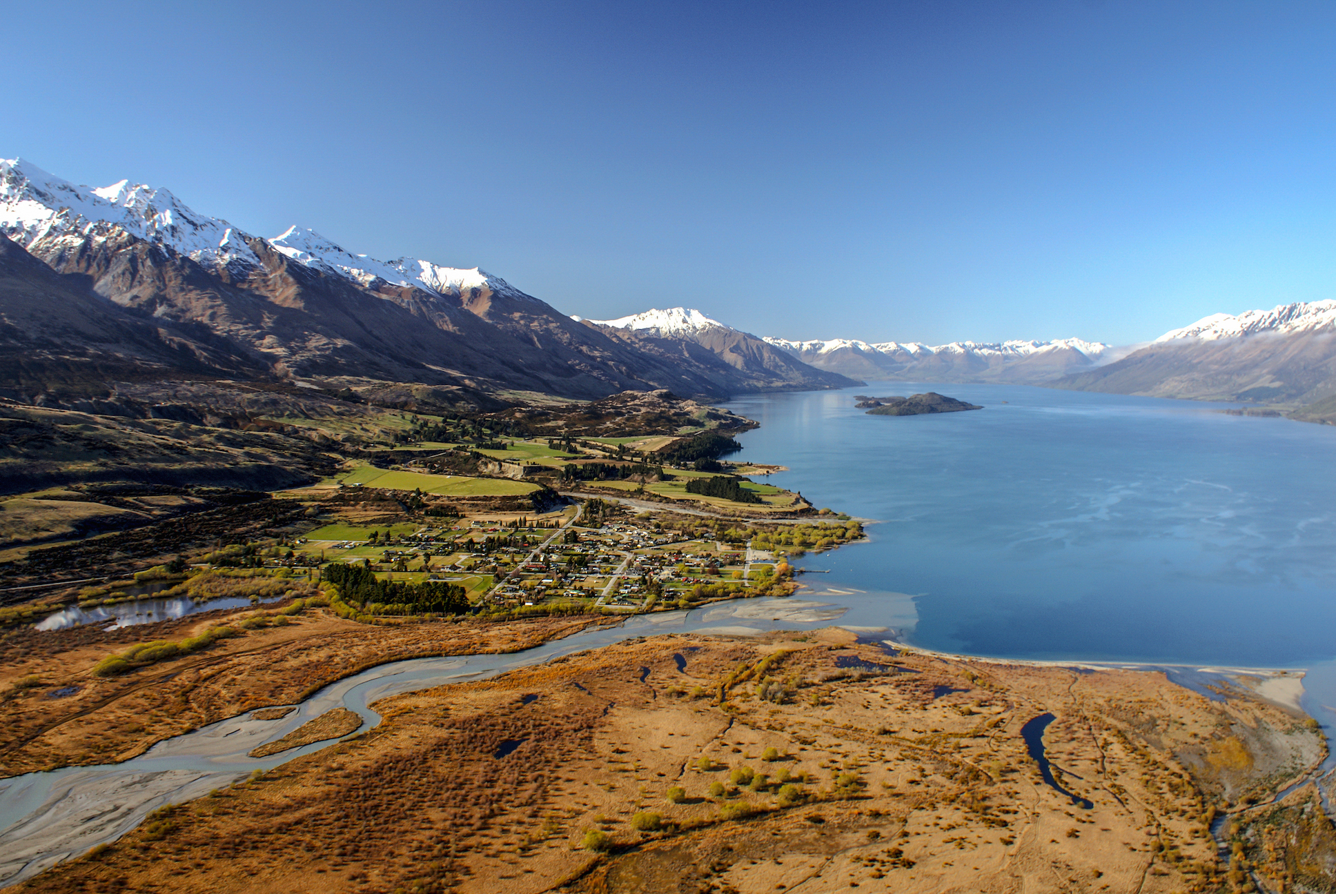
Glenorchy is a small settlement at the northern end of Lake Wakatipu in the South Island region of Otago, New Zealand. It is approximately 45 km by road or boat from Queenstown, the nearest large town. There are two pubs, a café and a range of small shops in the town catering mainly to tourists but also to the small resident population. There is also a small airstrip which caters to small planes.
The locality of Paradise is nearby.
The Dart River / Te Awa Whakatipu and Rees River flow into the head of Lake Wakatipu at Glenorchy, and Blanket Bay, an indentation in the coast of Lake Wakatipu, is just to the south of the settlement.
Naming
Glenorchy was named after Glen Orchy, a valley in Argyll, Scotland.
Demographics
Glenorchy is described by Statistics New Zealand as a rural settlement. It covers 3.93 km2 and had an estimated population of as of with a population density of people per km2. It is part of the much larger Glenorchy statistical area.
Glenorchy settlement had a population of 318 at the 2018 New Zealand census, an increase of 57 people (21.8%) since the 2013 census, and an increase of 126 people (65.6%) since the 2006 census. There were 129 households, comprising 159 males and 159 females, giving a sex ratio of 1.0 males per female, with 39 people (12.3%) aged under 15 years, 63 (19.8%) aged 15 to 29, 183 (57.5%) aged 30 to 64, and 33 (10.4%) aged 65 or older.
Ethnicities were 91.5% European/Pākehā, 6.6% Māori, 1.9% Pasifika, 3.8% Asian, and 3.8% other ethnicities. People may identify with more than one ethnicity.
Although some people chose not to answer the census's question about religious affiliation, 69.8% had no religion, 21.7% were Christian, 0.9% were Buddhist and 2.8% had other religions.
Of those at least 15 years old, 75 (26.9%) people had a bachelor's or higher degree, and 27 (9.7%) people had no formal qualifications. 36 people (12.9%) earned over $70,000 compared to 17.2% nationally. The employment status of those at least 15 was that 198 (71.0%) people were employed full-time, 36 (12.9%) were part-time, and 6 (2.2%) were unemployed.
Glenorchy statistical area
The Glenorchy statistical area also includes Paradise and covers 1464.37 km2. It had an estimated population of as of with a population density of people per km2.
The statistical area had a population of 450 at the 2018 New Zealand census, an increase of 87 people (24.0%) since the 2013 census, and an increase of 177 people (64.8%) since the 2006 census. There were 177 households, comprising 222 males and 225 females, giving a sex ratio of 0.99 males per female. The median age was 40.2 years (compared with 37.4 years nationally), with 51 people (11.3%) aged under 15 years, 84 (18.7%) aged 15 to 29, 261 (58.0%) aged 30 to 64, and 48 (10.7%) aged 65 or older.
Ethnicities were 92.0% European/Pākehā, 5.3% Māori, 2.0% Pasifika, 3.3% Asian, and 3.3% other ethnicities. People may identify with more than one ethnicity.
The percentage of people born overseas was 35.3, compared with 27.1% nationally.
Although some people chose not to answer the census's question about religious affiliation, 66.7% had no religion, 24.7% were Christian, 1.3% were Buddhist and 2.0% had other religions.
Of those at least 15 years old, 105 (26.3%) people had a bachelor's or higher degree, and 36 (9.0%) people had no formal qualifications. The median income was $38,000, compared with $31,800 nationally. 69 people (17.3%) earned over $70,000 compared to 17.2% nationally. The employment status of those at least 15 was that 276 (69.2%) people were employed full-time, 60 (15.0%) were part-time, and 6 (1.5%) were unemployed.
.jpg)
Activities
Glenorchy is a popular tourist spot, close to many tramping tracks. It lies near the borders of Mount Aspiring National Park and Fiordland National Park. The Routeburn Track, one of the New Zealand Great Walks can be accessed by passing through Glenorchy. Lesser known tracks such as the Greenstone and Caples Tracks and the Rees and Dart Tracks can also be accessed.
Some of the activities that can be experienced in or near Glenorchy include: canyoning, fly fishing, jet boating, horse riding, kayaking, mountain biking, skiing, snowboarding, skydiving and boating. Just past the Glenorchy Golf Club is a circular public boardwalk which passes through the Glenorchy Lagoon and is a popular short walk (3.2 km) for tourists and locals.
Dark sky sanctuary
Main article: Tāhuna Glenorchy Dark Sky Sanctuary
On 25 February 2025, DarkSky International announced the certification of the Tāhuna Glenorchy Dark Sky Sanctuary. This was the culmination of five years of work by a team within the Glenorchy Heritage and Museum Group. One of the attractions of the sanctuary is that it is amongst the few places on land where the core of the Milky Way can be seen, but the Aurora Australis can also be seen.
Film location
Films
- The local scenery was used as one of the settings in the first of Peter Jackson's The Fellowship of the Ring (2001), the first film in his Lord of the Rings series. Lothlórien, Orthanc, and the scene where Boromir was slain and leant near a tree were a few that were shot in nearby Paradise.
- Vertical Limit (2000), The Chronicles of Narnia: Prince Caspian (2008), and X-Men Origins: Wolverine (2009) were also filmed in the area.
- Other films that did location shots in Glenorchy and the surrounding area are Race for the Yankee Zephyr (1981) and The Water Horse (2007).
Television
- The 2013 BBC television miniseries Top of the Lake was also filmed in the area and was set in and around Paradise. While Queenstown is referred to during the series, Glenorchy doubles as the fictitious town of Laketop.
Education
Glenorchy School is a co-educational state primary school for Year 1 to 8 students, with a roll of as of . The first school in the area opened in 1884 at Kinloch, and another opened in 1888 on the road to Paradise. The present school opened near Buckleburn in 1911, and moved to its current site in 1939.
Climate
|access-date = 19 May 2024 |archive-date = 27 November 2015 |archive-url = https://web.archive.org/web/20151127002612/http://cliflo.niwa.co.nz/ |url-status = live
| Jan record high C = 18.8 | Feb record high C = 21.9 | Mar record high C = 15.5 | Apr record high C = 12.6 | May record high C = 12.6 | Jun record high C = 9.3 | Jul record high C = 8.8 | Aug record high C = 7.8 | Sep record high C = 9.4 | Oct record high C = 13.3 | Nov record high C = 15.7 | Dec record high C = 19.8 | year record high C = 21.9 |Jan record low C = -11.6 |Feb record low C = -8.4 |Mar record low C = -9.1 |Apr record low C = -17.0 |May record low C = -18.5 |Jun record low C = -18.7 |Jul record low C = -18.9 |Aug record low C = -18.4 |Sep record low C = -16.9 |Oct record low C = -14.2 |Nov record low C = -13.2 |Dec record low C = -10.4 |year record low C = -18.9 |access-date = 19 May 2024 |archive-date = 27 November 2015 |archive-url = https://web.archive.org/web/20151127002612/http://cliflo.niwa.co.nz/ |url-status = live |access-date = 6 Aug 2024}}
Blanket Bay
Blanket Bay, located just to the south of Glenorchy, is the site of the settlement's airstrip. The bay's name dates from the shearing of sheep in the area by 19th-century farmers, who would shelter in rudimentary tents close to the bay's shore made from blankets.
References
References
- "Address & Postcode Finder". New Zealand Post.
- (1978). "Shadows on the Hill". A.H. & A.W. Reed Ltd.
- "ArcGIS Web Application".
- {{NZ census 2018. 7027927 and 7027928
- {{NZ census 2018. Glenorchy (346000). glenorchy. Glenorchy
- Destination Queenstown, [https://www.queenstownnz.co.nz/listing/glenorchy-lagoon-walkway/9102/ Glenorchy Lagoon Walkway] {{Webarchive. link. (27 March 2024 , accessed 28 March 2024)
- Chortos, Natasha. (3 February 2025). "Tāhuna Glenorchy becomes New Zealand’s fifth International Dark Sky Sanctuary". [[DarkSky International]].
- "Our Team".
- (4 February 2025). "A new dark sky sanctuary". [[The Southland Times]].
- Herbert, Delphine. (4 February 2025). "Land at head of Lake Whakatipu becomes official International Dark Sky Sanctuary".
- (January 25, 2013). "Elisabeth Moss, ''Top of the Lake'' interview". Vulture.
- "Glenorchy School Ministry of Education School Profile". [[Ministry of Education (New Zealand).
- "Glenorchy School Education Review Office Report". [[Education Review Office]].
- "Glenorchy School Since 1884". Glenorchy School.
- "[https://blanketbay.com/about/history/ History]", ''blanketbay.com''. Retrieved 8 December 2024.
This article was imported from Wikipedia and is available under the Creative Commons Attribution-ShareAlike 4.0 License. Content has been adapted to SurfDoc format. Original contributors can be found on the article history page.
Ask Mako anything about Glenorchy, New Zealand — get instant answers, deeper analysis, and related topics.
Research with MakoFree with your Surf account
Create a free account to save articles, ask Mako questions, and organize your research.
Sign up freeThis content may have been generated or modified by AI. CloudSurf Software LLC is not responsible for the accuracy, completeness, or reliability of AI-generated content. Always verify important information from primary sources.
Report