From Surf Wiki (app.surf) — the open knowledge base
Garland County, Arkansas
County in Arkansas, United States

County in Arkansas, United States
| Field | Value |
|---|---|
| county | Garland County |
| state | Arkansas |
| seal | Official Seal of Garland County, Arkansas.png |
| founded year | 1873 |
| founded date | April 5 |
| seat wl | Hot Springs |
| largest city wl | Hot Springs |
| area_total_sq_mi | 735 |
| area_land_sq_mi | 678 |
| area_water_sq_mi | 57 |
| area percentage | 7.7% |
| population_as_of | 2020 |
| population_total | 100180 |
| pop_est_as_of | 2024 |
| population_est | 99902 |
| density_sq_mi | auto |
| web | http://www.garlandcounty.org/ |
| ex image | Garland County Courthouse 003.jpg |
| ex image cap | Garland County Courthouse |
| district | 4th |
| time zone | Central |
| named for | Augustus Hill Garland |
Garland County is a county located in the U.S. state of Arkansas. As of the 2020 census, the population was 100,180. The county seat is Hot Springs.
Garland County comprises the Hot Springs, Arkansas Metropolitan Statistical Area. The county includes Hot Springs National Park, the only national park in the state of Arkansas as well as the first property to be protected under federal legislation. A law was passed in 1832 supported by President Andrew Jackson to preserve this area, even before Arkansas was admitted as a state.
History
This area was occupied by the historic Natchitoches people, who frequented the hot springs for their healing powers. Their ancestors among regional indigenous peoples had been coming to this area for thousands of years before their time.
After acquiring the Louisiana Territory in 1803, which had been controlled by French and Spanish officials, President Thomas Jefferson requested William Dunbar, a planter and amateur scientist of Natchez, Mississippi, to explore this area. Dunbar led small group of a dozen soldiers and friend George Hunter, a chemist, to the Ouachita Mountains to report on the Indian tribes, minerals, and springs. They reached Hot Springs in December 1804, where they found a basic cabin used by visitors to the springs.
The first European-American settler was Jean Pierre Emanuel Prudhomme, a descendant of French colonists. An owner of a plantation at Red River, Prudhomme was suffering from illness and sought relief from the springs. In 1807 he built the first permanent European house by the springs, living here for two years. Isaac Cates and John Percival, two trappers from Alabama, joined him. Percival foresaw a great potential for the area and built log cabins in order to rent to visitors to the springs.
In 1828, Ludovicus Belding came with wife and children to visit the hot springs. After a few months they built a small hotel for the visitors of the springs.
In 1832 President Andrew Jackson signed legislation to protect the hot springs area for recreational use by American citizens as Hot Springs Reservation, the first time such action was taken. This was four years before Arkansas became a state, on June 15, 1836. A dispute among original settlers and their descendants over control of the property was settled by the US Supreme Court in 1877 in favor of the federal government. Hot Springs National Park was established in 1921 and is managed by the National Park Service.
Garland County is Arkansas' 68th county, formed during the Reconstruction era on April 5, 1873, from portions of Hot Spring, Montgomery, and Saline counties. It was named for Augustus H. Garland, eleventh governor of Arkansas. It is the only county in the United States with this name.
Geography
According to the U.S. Census Bureau, the county has a total area of 735 sqmi, of which 678 sqmi is land and 57 sqmi (7.7%) is water.
Transit
- Hot Springs Intracity Transit
Major highways
- [[Image:US 70.svg|20px]] U.S. Highway 70
- [[Image:US 270.svg|25px]] U.S. Highway 270
- [[Image:Arkansas 5.svg|20px]] Highway 5
- [[Image:Arkansas 7.svg|20px]] Highway 7
- [[Image:Arkansas 88.svg|20px]] Highway 88
Adjacent counties
- Perry County (north)
- Saline County (east)
- Hot Spring County (south)
- Montgomery County (west)
- Yell County (northwest)
National protected areas
- Hot Springs National Park
- Ouachita National Forest (part)
Demographics
| align-fn = center 1790–1960 1900–1990 1990–2000 2010
2020 census
As of the 2020 census, the county had a population of 100,180. The median age was 45.6 years. 20.4% of residents were under the age of 18 and 24.4% of residents were 65 years of age or older. For every 100 females there were 93.7 males, and for every 100 females age 18 and over there were 90.5 males age 18 and over.
The racial makeup of the county was 78.7% White, 8.1% Black or African American, 0.8% American Indian and Alaska Native, 1.0% Asian, 0.1% Native Hawaiian and Pacific Islander, 3.4% from some other race, and 8.0% from two or more races. Hispanic or Latino residents of any race comprised 7.0% of the population.
66.2% of residents lived in urban areas, while 33.8% lived in rural areas.
There were 42,997 households in the county, of which 25.5% had children under the age of 18 living in them. Of all households, 44.3% were married-couple households, 18.7% were households with a male householder and no spouse or partner present, and 30.0% were households with a female householder and no spouse or partner present. About 31.4% of all households were made up of individuals and 15.6% had someone living alone who was 65 years of age or older.
There were 52,326 housing units, of which 17.8% were vacant. Among occupied housing units, 67.6% were owner-occupied and 32.4% were renter-occupied. The homeowner vacancy rate was 2.3% and the rental vacancy rate was 11.2%.
2000 census
As of the 2000 United States census, there were 88,068 people, 37,813 households, and 25,259 families residing in the county. The population density was 130 /mi2. There were 44,953 housing units at an average density of 66 /mi2. The racial makeup of the county was 88.85% White, 7.80% Black or African American, 0.61% Native American, 0.50% Asian, 0.03% Pacific Islander, 0.72% from other races, and 1.49% from two or more races. 2.56% of the population were Hispanic or Latino of any race.
There were 37,813 households, out of which 25.10% had children under the age of 18 living with them, 53.20% were married couples living together, 10.10% had a female householder with no husband present, and 33.20% were non-families. 28.80% of all households were made up of individuals, and 13.50% had someone living alone who was 65 years of age or older. The average household size was 2.28 and the average family size was 2.78.
In the county, the population was spread out, with 21.30% under the age of 18, 7.30% from 18 to 24, 25.20% from 25 to 44, 25.10% from 45 to 64, and 21.20% who were 65 years of age or older. The median age was 42 years. For every 100 females there were 94.40 males. For every 100 females age 18 and over, there were 90.80 males.
The median income for a household in the county was $31,724, and the median income for a family was $38,079. Males had a median income of $28,117 versus $20,421 for females. The per capita income for the county was $18,631. About 10.50% of families and 14.60% of the population were below the poverty line, including 22.70% of those under age 18 and 8.60% of those age 65 or over.
Communities
Cities
- Hot Springs (county seat)
- Mountain Pine
Towns
- Fountain Lake
- Lonsdale
Census-designated places
- Crystal Springs
- Hot Springs Village
- Lake Hamilton
- Pearcy
- Piney
- Rockwell
Unincorporated communities
- Bear
- Jessieville
- Royal
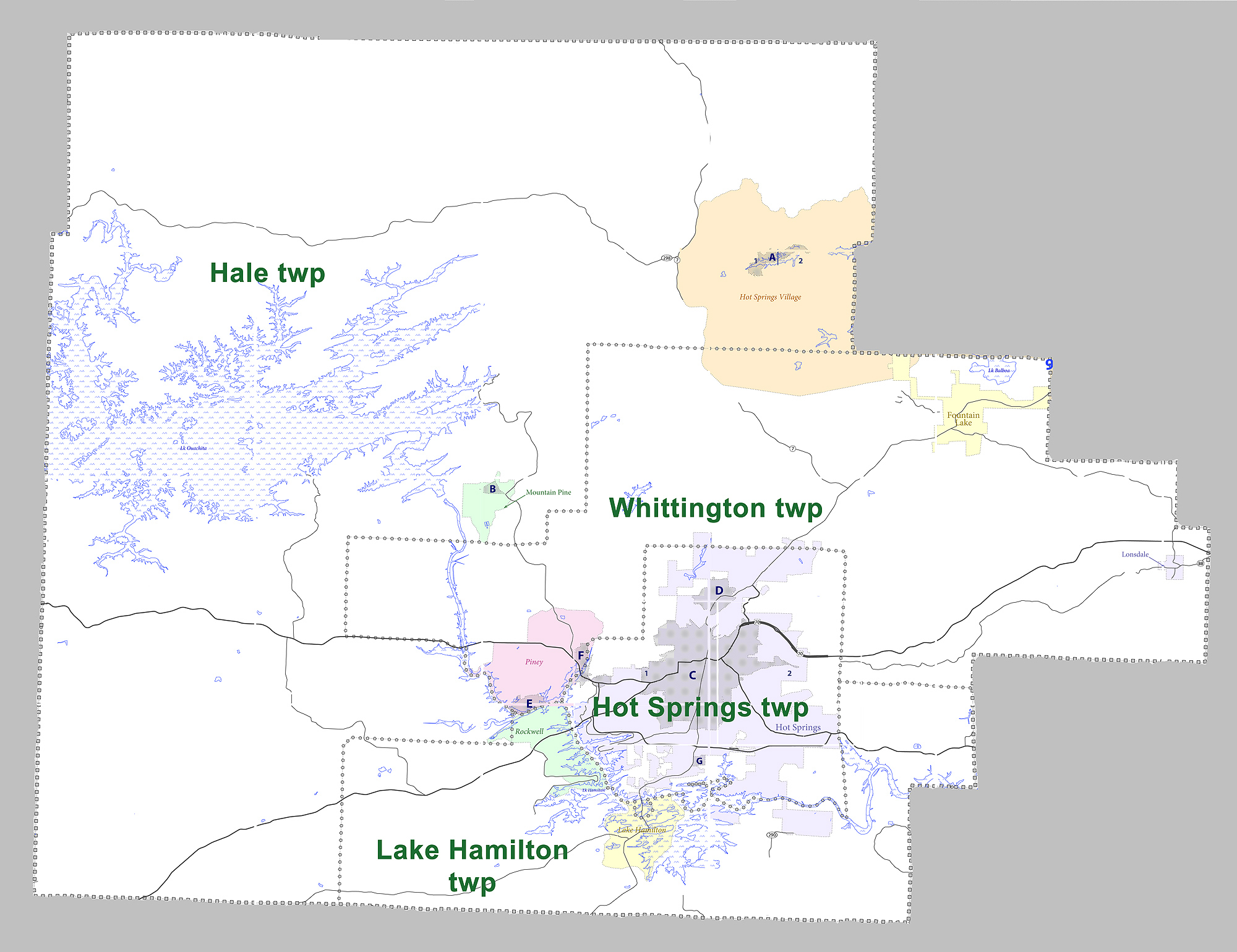
Townships
|access-date = August 14, 2011 |url-status = dead |archive-url = https://web.archive.org/web/20121019144704/http://www2.census.gov/geo/pvs/bas/bas11/st05_ar/cou/c05051_garland/BAS11C20505100000_000.pdf |archive-date = October 19, 2012
| Township | FIPS code | ANSI code | |||||||||||
|---|---|---|---|---|---|---|---|---|---|---|---|---|---|
| (GNIS ID) | Population | ||||||||||||
| center(s) | Pop. | ||||||||||||
| (2010) | Pop. | ||||||||||||
| density | |||||||||||||
| (/mi2) | Pop. | ||||||||||||
| density | |||||||||||||
| (/km2) | Total area | ||||||||||||
| (mi2) | Total area | ||||||||||||
| (km2) | Land area | ||||||||||||
| (mi2) | Land area | ||||||||||||
| (km2) | Water area | ||||||||||||
| (mi2) | Water area | ||||||||||||
| (km2) | Geographic coordinates | ||||||||||||
| Hale | Mountain Pine, most of CDP Hot Springs Village, small part of CDP Rockwell | 16,142 | 41.99 | 16.21 | 428.979 sqmi | 384.389 sqmi | 44.590 sqmi | ||||||
| Hot Springs | most of Hot Springs | 41,479 | 801.70 | 309.54 | 54.073 sqmi | 51.739 sqmi | 2.334 sqmi | ||||||
| Lake Hamilton | CDP Lake Hamilton, most of CDP Rockwell | 20,534 | 260.45 | 100.56 | 86.717 sqmi | 78.839 sqmi | 7.878 sqmi | ||||||
| Whittington | Fountain Lake, Lonsdale, CDP Piney, part of CDP Hot Springs Village, small part of Hot Springs | 17,599 | 108.09 | 41.73 | 164.852 sqmi | 162.814 sqmi | 2.038 sqmi | ||||||
| Source: |
Government and politics
Government
The county government is a constitutional body granted specific powers by the Constitution of Arkansas and the Arkansas Code. The quorum court is the legislative branch of the county government and controls all spending and revenue collection. Representatives are called justices of the peace and are elected from county districts every even-numbered year. The number of districts in a county vary from nine to fifteen, and district boundaries are drawn by the county election commission. The Garland County Quorum Court has thirteen members. Presiding over quorum court meetings is the county judge, who serves as the chief operating officer of the county. The county judge is elected at-large and does not vote in quorum court business, although capable of vetoing quorum court decisions.
| Position | Officeholder | Party |
|---|---|---|
| County Judge | Darryl Mahoney | Republican |
| County Clerk | Sarah Smith | Republican |
| Circuit Clerk | Kristie Womble-Hughes | Republican |
| Sheriff | Mike McCormick | Republican |
| Treasurer | Vivian Thomas | (Unknown) |
| Collector | Rebecca D. Talbert | Republican |
| Assessor | Shannon Sharp | Republican |
| Coroner | Jayson Neighbors | (Unknown) |
The composition of the Quorum Court following the 2024 elections is 12 Republicans and 1 Democrat. Justices of the Peace (members) of the Quorum Court following the elections are:
- District 1: Micah Braughton (R)
- District 2: Thomas J. Anderson (D)
- District 3: Susan Garner Jones (R)
- District 4: Jimmy Young (R)
- District 5: Ralf Bailes (R)
- District 6: Ben Hooten (R)
- District 7: Dayton Myers (R)
- District 8: Alan M. Floyd (R)
- District 9: Brian A. Peters (R)
- District 10: Debbie McGrew (R)
- District 11: Ronald T. Hunter (R)
- District 12: Jeremy W. Brown (R)
- District 13: Ralph Edds (R)
Additionally, the townships of Garland County are entitled to elect their own respective constables, as set forth by the Constitution of Arkansas. Constables are largely of historical significance as they were used to keep the peace in rural areas when travel was more difficult. The township constables as of the 2024 elections are:
- Hale: Jason Brasfield (R)
- Hot Springs: Jim Kerr (R)
- Lake Hamilton: Steve Thacker (R)
- Whittington: John McCaleb (R)
Politics
Over the past few election cycles Garland County has trended heavily towards the GOP. The last Democrat to carry this county was Arkansas “favorite son” Bill Clinton in 1996.
References
References
- "Census - Geography Profile: Garland County, Arkansas". [[United States Census Bureau]].
- "Find a County". National Association of Counties.
- [http://www.rootsweb.ancestry.com/~artttp/garland/index.html "Garland County: History"], Rootsweb
- on, Best Books. (April 27, 2018). "Arkansas: A Guide to the State". Best Books on.
- "The National Parks: Index 2009–2011". National Park Service.
- "Garland County - Encyclopedia of Arkansas".
- "Profile for Baxter County, Arkansas, AR". ePodunk.
- Gannett, Henry. (1905). "The Origin of Certain Place Names in the United States". Govt. Print. Off..
- (August 22, 2012). "2010 Census Gazetteer Files". United States Census Bureau.
- "Annual Estimates of the Resident Population for Counties: April 1, 2020 to July 1, 2023". United States Census Bureau.
- "U.S. Decennial Census". United States Census Bureau.
- "Historical Census Browser". University of Virginia Library.
- (March 27, 1995). "Population of Counties by Decennial Census: 1900 to 1990". United States Census Bureau.
- (April 2, 2001). "Census 2000 PHC-T-4. Ranking Tables for Counties: 1990 and 2000". United States Census Bureau.
- "State & County QuickFacts". United States Census Bureau.
- (2021). "2020 Decennial Census Demographic Profile (DP1)".
- (2021). "2020 Decennial Census Redistricting Data (Public Law 94-171)".
- (2023). "2020 Decennial Census Demographic and Housing Characteristics (DHC)".
- "U.S. Census website". [[United States Census Bureau]].
- "Arkansas: 2010 Census Block Maps - County Subdivision". [[United States Census Bureau]].
- "Quorum Courts".
- "Office of County Judge".
- "Garland {{!}} Association of Arkansas Counties".
- "Departments {{!}} Garland County, AR".
- (June 27, 2022). "2022 General Election: County, District Officials". Association of Arkansas Counties.
- "Justices of the Peace {{!}} Garland County, AR".
- (2015-06-26). "Contestation and Competitiveness in State Supreme Court Elections, 1946–2013". Cambridge University Press.
- "Garland County, Arkansas, elections, 2024".
- "What is a Constable?".
- "Dave Leip's Atlas of U.S. Presidential Elections".
This article was imported from Wikipedia and is available under the Creative Commons Attribution-ShareAlike 4.0 License. Content has been adapted to SurfDoc format. Original contributors can be found on the article history page.
Ask Mako anything about Garland County, Arkansas — get instant answers, deeper analysis, and related topics.
Research with MakoFree with your Surf account
Create a free account to save articles, ask Mako questions, and organize your research.
Sign up freeThis content may have been generated or modified by AI. CloudSurf Software LLC is not responsible for the accuracy, completeness, or reliability of AI-generated content. Always verify important information from primary sources.
Report