From Surf Wiki (app.surf) — the open knowledge base
Ganarew
Village in Herefordshire, England
Village in Herefordshire, England
| Field | Value |
|---|---|
| country | England |
| official_name | Ganarew |
| coordinates | |
| population | 171 |
| population_ref | (2011) |
| unitary_england | Herefordshire |
| region | West Midlands |
| lieutenancy_england | Herefordshire |
| constituency_westminster | Hereford and South Herefordshire |
| post_town | Monmouth |
| postcode_area | NP |
| postcode_district | NP25 |
| dial_code | 01600 |
| static_image_name | House at Ganarew - geograph.org.uk - 1203834.jpg |
| static_image_width | 250 |
| static_image_caption | Ganarew Manor |
Ganarew (from Welsh: Genau'r Rhiw; 'Gana-rhiw', and 'Gan y rew') is a village and small civil parish in south Herefordshire, England near the River Wye and the border with Wales. The village is located 0.62 mi southwest of the village of Whitchurch on the main A40 road, and lies within the electoral ward of Kerne Bridge. The village is about 2 mi from Monmouth and 8 mi from Ross-on-Wye. It contains the Church of St Swithin and Ganarew Manor.
History
The name Gana-rhiw, now Ganarew, may derive from the Briton "gan", from genau, meaning "a mouth or opening of a pass"; "rhiw" is a Welsh word for "hill" or "slope".
The Imperial Gazetteer of 1855 recorded Ganarew's population as 147, and that it was 835 acre in size. In 1868, the National Gazetteer noted that there was an observatory, 70 ft high, on the summit of nearby Little Doward Hill (or Ganarew Hill), from the top of which a view could be obtained of the Bristol Channel. By 1904, The Survey Gazetteer recorded the population as 132, and that there were 848 acre.
Legend
King Vortigern is said to have made his last stand against Aurelius at Ganarew. Lawman calls it a castle on Cloard Hill in the district of Hergin, and has Vortigern dying after the castle was besieged and fired by Aurelianus and Uther Pendragon.
A cave, at nearby Little Doward, known as "King Arthur's Cave" can be explored, making it unique amongst candidates for the Arthurian cave legend. Helen Hill Miller in her 1969 The Realms of Arthur, suggests a military use for the cave, arguing that the cave's "recesses penetrate very far into the hill, and could hide a substantial force". The cave has a parallel with Cadbury Castle in that it is a cave within a hillfort. It was first inhabited in the Old Stone Age and is thus older than any other Arthurian site.
Geography
Ganarew is located in the far south of Herefordshire, just across the border from Wales. Ganarew is located about 2 mi from Monmouth and 8 mi from Ross-on-Wye. The River Wye flows to the southeast of the village. Little Doward and Great Doward lie to the east. Woods in the area include Sanger Wood, Millennium Wood, Hazel Wood and Goldsmith's Wood to the south.
Notable landmarks
Church of St Swithin
Main article: Church of St Swithin, Ganarew
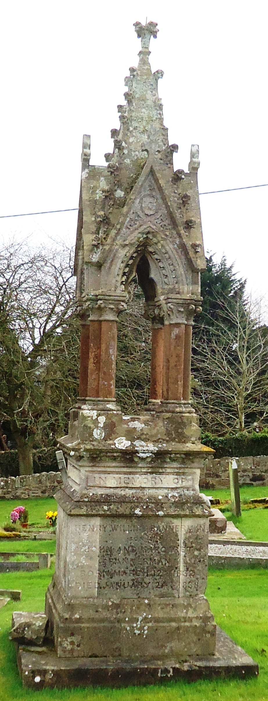
The parish church, which is within the Church of England Diocese of Hereford, is dedicated to St Swithin. A Grade II listed building, it was rebuilt in about 1850 by John Prichard. The graveyard contains a Gothic pinnacle memorial to the Bannerman family who lived nearby at Wyastone Leys.
Ganarew Manor
The manor dates from the 17th century, with mid-19th and early-20th-century alterations. The house is of stone with a slate roof, the 20th century extensions including a two-storey block with a bay window and a gabled porch. The manor was the home of Sir Colin Sheperd, former Member of Parliament for Hereford and is a Grade II listed building. The gate to the manor, with accompanying piers, is also a Grade II listed structure.
Ancient monuments
The Church of St Swithin churchyard contains a standing stone cross, of stepped form, which is a scheduled historical monument. It is principally medieval with some later additions and includes the foundation, the base of two steps and a socket stone. The shaft, knop and head are modern.
Other ancient monuments are noted by English Heritage at Ganarew Cross, and at Little Doward camp, the remains of an Iron Age hillfort. The Wye Valley Walk passes close to the south of the camp.
Transport
In 1755 a road was constructed from Monnow Bridge to Gan y rew. In the late 18th century, the turnpike route to Ross in the area of Ganarew Hill was described as being in such bad condition that it was a travel danger. The Hereford Trust took over road work for the section between Old Forge and Ganarew in 1819. Plans in the early 19th century to build a connecting road between St. Weonards and Ganarew were not carried out.
References
References
- "Civil Parish population 2011".
- Blackie, Walter Graham. (1855). "The imperial gazetteer: a general dictionary of geography, physical, political, statistical and descriptive ...". Blackie.
- Murray, John. (1872). "A handbook for travellers in Gloucestershire, Worcestershire, and Herefordshire ...". J. Murray.
- [http://www.genuki.org.uk/big/eng/HEF/Ganarew/Gaz1868.html "Extract from National Gazetteer, 1868" at genuki.org.uk]
- Bartholomew, John George. (1904). "The survey gazetteer of the British Isles, topographical, statistical, and commercial: compiled from the 1901 census and the latest official returns". G. Newnes, limited.
- [http://www.vortigernstudies.org.uk/artcit/caerdoward.htm "Caer Guorthegirn", by Robert Vermaat, at vortigernstudies.org.uk]
- [http://www.vortigernstudies.org.uk/artgue/guestjakejoe2.htm "Arthur's Cave near Little Doward, Ganarew", by Joe Boyles and Jake Livingston, at vortigernstudies.org.uk]
- Murray, John. (1872). "A Handbook for Travellers in Gloucestershire, Worcestershire, and Herefordshire ...". J. Murray.
- "Maps". [[Google Maps]].
- [http://www.achurchnearyou.com/ganarew-st-swithin/ "Ganarew: St Swithin, Ganarew" at achurchnearyou.com]
- "Church of St Swithin, Ganarew". British Listed Buildings.
- (1934). "An inventory of the historical monuments in Herefordshire". H. M. Stationery off., printed by William Clowes & sons, ltd..
- Pevsner, Nikolaus. (1963). "Herefordshire". Yale University Press.
- {{NHLE
- Good Stuff IT Services. (3 July 1985). "The Manor House - Ganarew - Herefordshire - England". British Listed Buildings.
- (9 June 2011). "Open Garden at The Manor House, Ganarew - St Michael's Hospice | Specialist palliative care for life-limiting conditions". St-michaels-hospice.org.uk.
- Good Stuff IT Services. (3 July 1985). "The Manor House - Ganarew - Herefordshire - England". British Listed Buildings.
- Good Stuff IT Services. (3 July 1985). "Gate Piers and Gate to Manor House - Ganarew - Herefordshire - England". British Listed Buildings.
- {{NHLE
- {{NHLE
- {{NHLE
- link. (9 June 2011)
- Hurley, Heather. (30 September 2007). "The Old Roads of South Herefordshire". Fineleaf Editions.
This article was imported from Wikipedia and is available under the Creative Commons Attribution-ShareAlike 4.0 License. Content has been adapted to SurfDoc format. Original contributors can be found on the article history page.
Ask Mako anything about Ganarew — get instant answers, deeper analysis, and related topics.
Research with MakoFree with your Surf account
Create a free account to save articles, ask Mako questions, and organize your research.
Sign up freeThis content may have been generated or modified by AI. CloudSurf Software LLC is not responsible for the accuracy, completeness, or reliability of AI-generated content. Always verify important information from primary sources.
Report