From Surf Wiki (app.surf) — the open knowledge base
Gabriola Island
| Field | Value | |
|---|---|---|
| <!-- Basic info ----------------> | official_name | Gabriola Island |
| settlement_type | Island | |
| motto | ||
| image_skyline | Taylor_Bay_Gabriola.JPG | |
| image_caption | Beach at Descanso Bay | |
| image_flag | Gabriola Island Flag.jpg | |
| flag_size | 150px | |
| image_map | {{superimpose | |
| base | Gulf Islands map 2.png | |
| base_width | 300px | |
| float | Cercle rouge 100%.svg | |
| float_width | 45px | |
| x | 28 | y = 28 |
| pushpin_map | Vancouver Island#British Columbia | |
| pushpin_label_position | ||
| pushpin_map_caption | Location of Gabriola, near Vancouver Island | |
| pushpin_mapsize | ||
| subdivision_type | Country | |
| subdivision_name | Canada | |
| subdivision_type1 | Province | |
| subdivision_name1 | British Columbia | |
| subdivision_type2 | Regional district | |
| subdivision_name2 | Nanaimo | |
| subdivision_name3 | ||
| leader_title | ||
| leader_title1 | ||
| established_title | ||
| established_date | ||
| area_total_km2 | 57.6 | |
| area_land_km2 | ||
| area_water_km2 | ||
| population_as_of | 2021 | |
| population_total | 4500 | |
| population_density_km2 | 78.1 | |
| <!-- General information ---------------> | timezone | Pacific Time Zone |
| utc_offset | −8 | |
| timezone_DST | Pacific Daylight Time | |
| utc_offset_DST | −7 | |
| coordinates | ||
| elevation_footnotes | ||
| elevation_m | ||
| postal_code_type | Postal code span | |
| postal_code | V0R | |
| area_code | Area code 250 |
Gabriola Island is one of the Gulf Islands in the Strait of Georgia in British Columbia (BC), Canada. It is about 5 km east of Nanaimo on Vancouver Island, to which it is linked by a 20-minute ferry service. It has a land area of about 57.6 km2 and a resident population of 4,500.
Gabriola has public beaches and forests, shopping centres, restaurants, a library, an elementary school and a museum. It is known as the Isle of the Arts due to its high percentage of working artists, and its many cultural events include annual festivals related to art, poetry, gardens, music, boating and fishing. The Gabriola Arts Council produces three large annual events: the Isle of the Arts Festival (April), Cultivate Arts Festival (Summer) and Thanksgiving Studio Tour (October).
History
Pre-contact
Gabriola is part of the traditional territory of the Snunéymux{{cite web | access-date = 2008-04-15 }} (of whose name the nearby city of Nanaimo was given an anglicized form{{cite web | access-date = 2008-04-15 | archive-url = https://web.archive.org/web/20080411185747/http://nanaimo-info.com/gpage.html7.html | archive-date = 11 April 2008 | url-status = dead
The pre-contact population of Gabriola is difficult to estimate, but in mid-Marpole times—between about AD 1 and 1000—several thousand people lived in the village at Senewélets or more commonly known as, False Narrows, the site of today's El Verano Drive. Archaeologists have found that infant mortality at that time was surprisingly low and that the population was well adapted to its environment. Other smaller villages on Gabriola were scattered around the coast. After contact, and perhaps as early as AD 1500, the population of the Snunéymux declined drastically from smallpox and other diseases brought to North America by Europeans.{{cite journal | last = Littlefield | first = Lorraine
The island is famous for its petroglyphs, which, while commonly believed to be thousands of years old, are almost impossible to date. Because they are carved in relatively soft sandstone, they are eroding rapidly.
Post-contact
The first European visit to Gabriola was by the Spanish schooner Santa Saturnina under José María Narváez in 1791. Narváez is said to have given the name Punta de Gaviola to the southeastern end of the island. It may also have been Juan Francisco de la Bodega y Quadra, rather than Narváez, who bestowed the name. Over time, "Gaviola" may have been corrupted into "Gabriola" and applied to the whole island. Gaviola is sometimes said to be a misspelling of gaviota ("seagull"), but it may refer to the Spanish surname Gaviola.
In 1792, the island was again visited by a Spanish expedition, under Galiano and Valdés. Galiano and Valdés stayed at Pilot Bay for several days, to repair their vessels and explore the vicinity of what is now Nanaimo. They called the anchorage Cala del Descanso ("Cove of Rest"). Galiano stayed at the island for four days and while there, encountered several Indians and engaged in limited trading. Galiano also found an abandoned Indian village. This site was later wrongly identified as the present Descanso Bay by British cartographers. The British expedition of George Vancouver may also have visited the island very briefly in 1792.{{cite journal
By 1874, 17 settlers were working the land on Gabriola, and two-thirds of those had First Nations wives and young families. Portuguese settler John Silva, for whom Silva Bay was named, married "Louise," the daughter of a Cowichan chief, in 1873. Three of their sons volunteered to fight in the First World War; one was killed, another wounded. The name of Frank Silva, missing in action on Vimy Ridge in 1917, is inscribed on the Vimy Memorial in France.
In 1891, the population of the Gabriola Island subdistrict was of 125. In the early 20th century, the population of Gabriola grew slowly. By the 1950s, fewer than 400 people lived full-time on the island. Electricity came to Gabriola in 1955, but even then the population grew only about one percent a year until the 1970s. In roughly the next 10 years, the population tripled, in part due to hippie immigration from the United States. By the mid-1980s, the population was 2,000, half the current figure.
In summer, the island's population greatly increases. Even in the first half of the 20th century, families came from Nanaimo or Vancouver to estivate, spending weeks or months living a simpler, rural life on the island. In the 21st century, about 2,000 estivators come to Gabriola each year for the sun, music, art, and relaxed pace, and they raise the population temporarily to about 6,000.
Apart from farming, Gabriola experienced industrial development in the 20th century. A brickyard produced 80,000 high-quality bricks a day in the early part of the century, and they were sent principally to Victoria and Vancouver.{{cite journal
Geography
Gabriola, part of the Regional District of Nanaimo, is the most northerly of the Southern Gulf Islands in the Strait of Georgia between mainland BC to the east and Vancouver Island to the west. The Gulf Islands are an archipelago consisting of hundreds of islands of various sizes stretching from the San Juan Islands in the United States to the Northern Gulf Islands, north of Gabriola. The biggest of the Southern Gulf Islands are Gabriola Island, Galiano Island, Penelakut Island, North and South Pender Island, Saltspring Island, Saturna Island, Thetis Island, and Valdes Island.
The Southern Gulf Islands consist mainly of former seabed sediments crumpled and gradually thrust upward by tectonic plate movement approximately 55 to 42 million years ago.{{cite web | title = Geological History of Vancouver Island | publisher = Capital Regional District | url = http://www.crd.bc.ca/watersheds/protection/geology-processes/geologicalhistoryVI.htm | access-date = 2007-07-30 }} Subsequent periods of glaciation scraped away topsoil and some of the bedrock. During the peak of the Fraser Glaciation, 30,000 to 11,000 years ago, Gabriola was covered with ice up to 2 km thick.{{cite journal | last = Doe | first = Nick
Gabriola is about 14 km long by 4.2 km wide on average with a land area of 57.6 km2.{{cite web | title = Gabriola Island Trust Area, Nanaimo B Regional District Electoral Area, British Columbia | publisher = Statistics Canada | access-date = 2007-07-29 }} The topography varies from flat sandy beaches at sea level to forested hills rising to 160 m on Stoney Ridge in the centre of the island.
Gabriola lies about 5 km east of Nanaimo, the second largest city on Vancouver Island, to which it is linked by BC Ferries. The ferry, which takes 20 minutes for the crossing, runs almost hourly from 6:15 a.m, starting at the Gabriola side, to about 11:00 p.m. ,from Nanaimo, daily. Residents of Gabriola who work or attend high school in Nanaimo use the ferry to commute. Gabriola may also be reached by float plane or small boat.
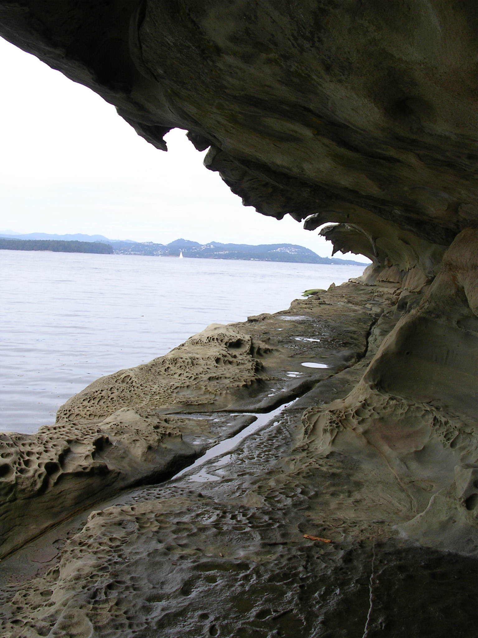
The island has three provincial parks—Gabriola Sands Provincial Park on the northwest shore, Sandwell Provincial Park on the northeast shore, and Drumbeg Provincial Park on the east shore—as well as Descanso Bay Regional Park and an adjacent community park near the ferry terminal. Large coastal sandstone formations known as the Malaspina Galleries are preserved in this community park. The formations were named after the 18th-century Spanish explorer Alejandro Malaspina.
Demographics
The population of Gabriola rose by 15 percent, from 3,522 to 4,050, between 2001 and 2006. This growth rate was higher than that for BC as a whole, which grew at a rate of 5.3 percent. The population density was 70.3 /km2 in 2006 compared to 4.4/km2 (11.4 mi2) for all of BC.
The total number of private dwellings on Gabriola was 2,744 in 2006, of which 1,998 were occupied by the usual residents. The median age of the population was 52.9 years compared to the BC median of 40.8. Of the total population, 1,960 were male and 2,090 were female.
Climate
Under the Köppen climate classification, the island has a cool summer Mediterranean climate due to its dry summers.{{cite journal | access-date = 2012-08-23
|Jan record high C = 14.5 |Feb record high C = 15.0 |Mar record high C = 20.5 |Apr record high C = 25.0 |May record high C = 31.0 |Jun record high C = 30.0 |Jul record high C = 32.0 |Aug record high C = 31.0 |Sep record high C = 30.0 |Oct record high C = 24.0 |Nov record high C = 18.0 |Dec record high C = 13.5 |year record high C = 32.0 |Jan record low C = -16.0 |Feb record low C = -12.0 |Mar record low C = -6.0 |Apr record low C = -4.0 |May record low C = -2.0 |Jun record low C = 2.0 |Jul record low C = 4.0 |Aug record low C = 4.5 |Sep record low C = 0.0 |Oct record low C = -4.5 |Nov record low C = -14.0 |Dec record low C = -15.0 |year record low C = -16.0
Community
Island festivals include the annual Isle of the Arts Festival in April, Cultivate Festival in July, and the Thanksgiving Studio Tour, all three events produced by the Gabriola Arts Council. The Concert on the Green and the Annual Salmon Barbecue occur in August. From May to October, the great Saturday Market at the Agricultural Hall features local produce and baked goods from the island, as well as crafts and high-quality artwork. [[Habonim Dror] Camp Miriam, a Jewish summer camp, operates on the island from the end of June through the end of August.

Gabriola and surrounding islands have more than 70 known petroglyphs – sandstone carvings, some of which may be as old as 2,000 years or more. A small park at the Gabriola Museum contains reproductions of some of these petroglyphs.
Flora and fauna
Plants which are common to the island include the trees Douglas fir, grand fir, Rocky Mountain juniper, Western hemlock, Western red cedar, arbutus, Garry oak, big leaf maple, red alder, and Pacific dogwood; the shrubs Oregon grape and red-flowering currant; the perennial bulb small camas (common camas); the semi-aquatic or terrestrial herb Western skunk cabbage (swamp lantern); and the evergreen perennial Western sword fern.{{cite web | access-date = 2008-04-10}}
Marine species near Gabriola include orcas (killer whales), sea lions, seals, otters, oysters, mussels, clams, basket cockles, moon snails, whelks, wolf eels, Pacific herring, octopuses, and salmon. Deer and raccoons are among the island's more common land animals.
In the winter months Gabriola is visited by many species of waterfowl such as the scoter, bufflehead, Barrow's goldeneye, and harlequin duck. Shorebirds such as the black turnstone and ruddy turnstone frequent the island as do garden birds such as the ruby-crowned kinglet, golden-crowned kinglet, thrushes, warblers, pileated woodpeckers, and flickers. The bald eagle, common raven, European starling, peafowl and feral turkey are common year round. The Nanaimo–Gabriola area is populated by over 250 bird species, some of which are migratory species traversing the Pacific Flyway while others are year-round residents{{cite web |access-date=2007-07-31 |archive-url=https://web.archive.org/web/20070928042557/http://www.getawaybc.com/story.cgi?id=2570&keyword=gabriola |archive-date=28 September 2007 |url-status=dead
References
References
- (2022-02-09). "Profile table, Census Profile, 2021 Census of Population – Gabriola Island Trust Area, Island trust (IST) [Designated place], British Columbia". Government of Canada.
- (1989). "Senewélets: culture history of the Nanaimo Coast Salish and the False Narrows Midden". Royal British Columbia Museum.
- {{BCGNIS. 5212. Gabriola Island
- Kendrick, John. (1990). "The Voyage of ''Sutil'' and ''Mexicana'', 1792: The last Spanish exploration of the Northwest Coast of America". The Arthur H. Clark Company.
- (1999). "Spanish Contact: 1791 and 1792". Gabriola Historical and Museum Society.
- (2007). "History of Fort Langley". Fort Langley BIA.
- (2005). "Nanaimo Free Press: Gabriola Island". Gabriola Historical & Museum Society.
- "Portuguese Pioneers of BC".
- "Family histories of early settlers on Gabriola Island".
- Government of Canada (Department of Agriculture, Census Branch). ''[https://publications.gc.ca/collections/collection_2016/statcan/CS98-1891-1.pdf Census of Canada, 1890-1891]'', 1893, table 2.
- "Gabriola Co-op Radio". Gabriola Co-op Radio.
- [http://www.fao.org/docrep/006/ad652e/ad652e07.htm Global Ecological Zoning for the Global Forest Resources Assessment 2000]
- link. (16 December 2012 , retrieved 23 August 2012)
- (2007). "Gabriola Petroglyphs". Gabriola Historical and Museum Society.
- "Gabriola Island". Shangaan Webservices, Inc.
- McInnes {{!}}, Sharon. (2015-01-28). "Celebrating the Birds of Gabriola".
This article was imported from Wikipedia and is available under the Creative Commons Attribution-ShareAlike 4.0 License. Content has been adapted to SurfDoc format. Original contributors can be found on the article history page.
Ask Mako anything about Gabriola Island — get instant answers, deeper analysis, and related topics.
Research with MakoFree with your Surf account
Create a free account to save articles, ask Mako questions, and organize your research.
Sign up freeThis content may have been generated or modified by AI. CloudSurf Software LLC is not responsible for the accuracy, completeness, or reliability of AI-generated content. Always verify important information from primary sources.
Report