From Surf Wiki (app.surf) — the open knowledge base
Frisco, Utah

| Field | Value |
|---|---|
| name | Frisco, Utah |
| settlement_type | Ghost town |
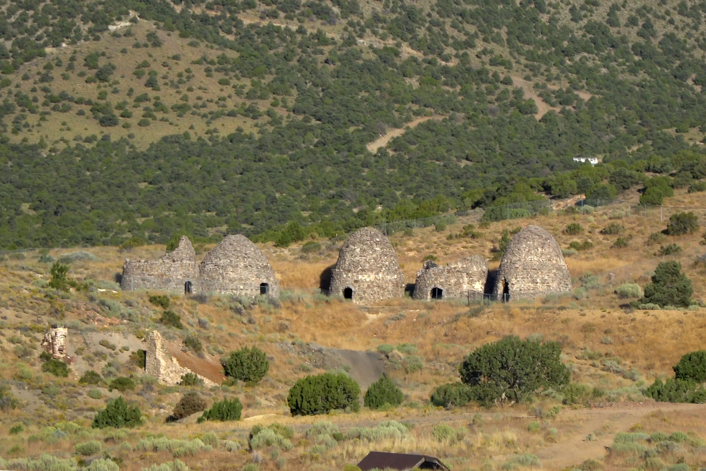
| image_skyline | FriscoGhostTown.jpg |
| image_caption | Remains of Frisco. The charcoal kilns in the background are listed on the National Register of Historic Places. |
| pushpin_map | Utah#USA |
| pushpin_label | Frisco |
| pushpin_label_position | right |
| map_caption | Location of Frisco in Utah |
| subdivision_type | Country |
| subdivision_name | United States |
| subdivision_type1 | State |
| subdivision_name1 | Utah |
| subdivision_type2 | County |
| subdivision_name2 | Beaver |
| established_title | Established |
| established_date | 1879 |
| named_for | San Francisco Mountains |
| extinct_title | Abandoned |
| extinct_date | 1929 |
| elevation_footnotes | |
| elevation_ft | 6421 |
| elevation_m | 1957 |
| coordinates | |
| blank_name | GNIS feature ID |
| blank_info | 1437563 |
Frisco is a ghost town in Beaver County, Utah, United States. It was an active mining camp from 1879 to 1929. At its peak in 1885, Frisco was a thriving town of 6,000 people.
History
Frisco developed as the post office and commercial center for the San Francisco Mining District, and was the terminus of the Utah Southern Railroad extension from Milford. The Horn Silver Mine was discovered in 1875, and had produced $20,267,078 worth of ore by 1885. By 1885, over $60,000,000 worth of zinc, copper, lead, silver, and gold had been transported from Frisco from the many mines in the area.
With 23 saloons, Frisco was known as the wildest town in the Great Basin. Murder was common, and drinking water had to be freighted in.
Frisco's fortunes changed suddenly on February 13, 1885, when the Horn Silver Mine caved in completely. It was an unconventional mine, an open pit 900 ft deep braced with timbers, and could have collapsed at any time.
In 1905 a Mormon ward was organized, but in 1911, with the closing of many of the mines, so many church members had left that the ward was discontinued. After many years of desertion, another company made an attempt to mine here in 2002.

Geography
Frisco is located at . Its elevation is 6500 ft.
Demographics
The peak population was nearly 6,000.
| Year | Population |
|---|---|
| 1880 | 800 |
| 1900 | 500 |
| 1912 | 150 |
| 1918 | 300 |
| 1922–1923 | 100 |
| 1927–1928 | 100 |
References
References
- {{gnis. 1437563. Frisco
- (April 2005). "Frisco, Utah - Ghost town with a ten year high". legendsofamerica.com.
- Notarianni, Philip F.. (1994). "Utah History Encyclopedia". University of Utah Press.
- "Frisco, Utah the Ghost Town".
- Carr, Stephen L.. (1986). "The Historical Guide to Utah Ghost Towns". Western Epics.
- Thompson, George A.. (November 1982). "Some Dreams Die: Utah's Ghost Towns and Lost Treasures". Dream Garden Press.
- Jenson, Andrew. (1941). "Encyclopedic History of The Church of Jesus Christ of Latter-day Saints". Deseret news Press.
- Buchanan, Joseph F.. (1996-06-06). "Utah Almanac D-H". Utah Almanac.
This article was imported from Wikipedia and is available under the Creative Commons Attribution-ShareAlike 4.0 License. Content has been adapted to SurfDoc format. Original contributors can be found on the article history page.
Ask Mako anything about Frisco, Utah — get instant answers, deeper analysis, and related topics.
Research with MakoFree with your Surf account
Create a free account to save articles, ask Mako questions, and organize your research.
Sign up freeThis content may have been generated or modified by AI. CloudSurf Software LLC is not responsible for the accuracy, completeness, or reliability of AI-generated content. Always verify important information from primary sources.
Report