From Surf Wiki (app.surf) — the open knowledge base
Fremont County, Iowa
County in Iowa, United States
County in Iowa, United States
| Field | Value |
|---|---|
| county | Fremont County |
| state | Iowa |
| ex image | FREMONT COUNTY COURTHOUSE.jpg |
| ex image cap | Fremont County Courthouse |
| founded | 1847 |
| seat wl | Sidney |
| largest city wl | Sidney |
| area_total_sq_mi | 517 |
| area_land_sq_mi | 511 |
| area_water_sq_mi | 5.5 |
| area percentage | 1.1 |
| population_as_of | 2020 |
| population_total | 6605 |
| pop_est_as_of | 2024 |
| population_est | 6494 |
| density_sq_mi | auto |
| time zone | Central |
| web | https://www.fremontcountyia.gov/ |
| district | 3rd |
| named for | John C. Fremont |
| footnotes | * Iowa county number 36 |
Fremont County is a county located in the U.S. state of Iowa. As of the 2020 census the population was 6,605, making it the state's seventh-least populous county. The county seat and the largest city is Sidney. The county was formed in 1847 and named for the military officer John C. Frémont.
Geography
According to the United States Census Bureau, the county has a total area of 517 sqmi, of which 511 sqmi is land and 5.5 sqmi (1.1%) is water.
Major highways
- [[File:I-29.svg|x20px]] Interstate 29
- [[File:US 59.svg|x20px]] U.S. Highway 59
- [[File:US 275.svg|x20px]] U.S. Highway 275
- [[File:Circle sign 2.svg|x20px]] Iowa Highway 2
- [[File:Elongated circle 333.svg|x20px]] Iowa Highway 333
Adjacent counties
- Mills County (north)
- Page County (east)
- Atchison County, Missouri (south)
- Otoe County, Nebraska (southwest)
- Cass County, Nebraska (northwest)
History
Fremont County was impacted by the 2019 Midwestern U.S. floods. Buyouts are under discussion for residents in Hamburg and McPaul.
On April 17, 2025, several homes and businesses Fremont County were damaged by an intense hailstorm. The hail was caused by a larger storm system that spawned a tornado in southwestern Iowa.
Demographics
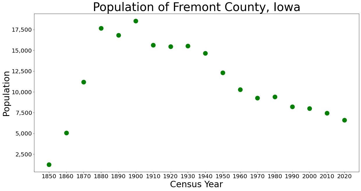
|align-fn=center 1790–1960 1900–1990 1990–2000 2010–2020
2020 census

As of the 2020 census, the county had a population of 6,605 and a population density of . The median age was 45.7 years, 22.5% of residents were under the age of 18, and 23.2% of residents were 65 years of age or older. For every 100 females there were 101.4 males, and for every 100 females age 18 and over there were 99.6 males age 18 and over.
95.65% of the population reported being of one race. The racial makeup of the county was 93.9% White, 0.2% Black or African American, 0.3% American Indian and Alaska Native, 0.2% Asian, 0.1% Native Hawaiian and Pacific Islander, 1.1% from some other race, and 4.3% from two or more races. Hispanic or Latino residents of any race comprised 2.9% of the population.
0.1% of residents lived in urban areas, while 99.9% lived in rural areas.
There were 2,720 households in the county, of which 26.3% had children under the age of 18 living in them. Of all households, 53.2% were married-couple households, 18.5% were households with a male householder and no spouse or partner present, and 20.4% were households with a female householder and no spouse or partner present. About 27.5% of all households were made up of individuals and 13.6% had someone living alone who was 65 years of age or older.
There were 3,110 housing units, of which 12.5% were vacant. Among occupied housing units, 77.3% were owner-occupied and 22.7% were renter-occupied. The homeowner vacancy rate was 2.6% and the rental vacancy rate was 5.4%.
2010 census
The 2010 census recorded a population of 7,441 in the county, with a population density of . There were 3,431 housing units, of which 3,064 were occupied.
2000 census
As of the census of 2000, there were 8,010 people, 3,199 households, and 2,242 families residing in the county. The population density was 16 /mi2. There were 3,514 housing units at an average density of 7 /mi2. The racial makeup of the county was 98.01% White, 0.04% Black or African American, 0.24% Native American, 0.24% Asian, 0.96% from other races, and 0.51% from two or more races. 2.17% of the population were Hispanic or Latino of any race.
There were 3,199 households, out of which 30.20% had children under the age of 18 living with them, 58.90% were married couples living together, 8.20% had a female householder with no husband present, and 29.90% were non-families. 26.30% of all households were made up of individuals, and 14.90% had someone living alone who was 65 years of age or older. The average household size was 2.45 and the average family size was 2.93.
In the county, the population was spread out, with 25.10% under the age of 18, 6.00% from 18 to 24, 24.30% from 25 to 44, 24.70% from 45 to 64, and 19.80% who were 65 years of age or older. The median age was 41 years. For every 100 females there were 95.50 males. For every 100 females age 18 and over, there were 91.80 males.
The median income for a household in the county was $38,345, and the median income for a family was $46,547. Males had a median income of $30,822 versus $23,003 for females. The per capita income for the county was $18,081. About 6.50% of families and 9.50% of the population were below the poverty line, including 11.40% of those under age 18 and 10.70% of those age 65 or over.
Communities
Cities
- Farragut
- Hamburg
- Imogene
- Randolph
- Riverton
- Shenandoah (part)
- Sidney
- Tabor
- Thurman
Census-designated places
- Anderson
- Bartlett
- Percival
Other unincorporated places
- Civil Bend
- McPaul
Townships
Fremont County is divided into thirteen townships:
- Benton
- Fisher
- Green
- Locust Grove
- Madison
- Monroe
- Prairie
- Riverside
- Riverton
- Scott
- Sidney
- Walnut
- Washington
Population ranking
The population ranking of the following table is based on the 2020 census of Fremont County.
† county seat
| Rank | City, town, etc. | Municipal type | Population (2020 Census) |
|---|---|---|---|
| 1 | † Sidney | City | 1,070 |
| 2 | Hamburg | City | 890 |
| 3 | Tabor (partially in Mills County) | City | 928 (1,014 total) |
| 4 | Farragut | City | 490 |
| 5 | Riverton | City | 245 |
| 6 | Randolph | City | 189 |
| 7 | Thurman | City | 167 |
| 8 | Percival | CDP | 53 |
| 9 | Imogene | City | 39 |
| 10 | Anderson | CDP | 37 |
| 11 | Bartlett | CDP | 5 |
| 12 | Shenandoah (mostly in Page County) | City | 0 (4,925 total) |
Politics
Prior to 1944, Fremont County was a swing county in presidential elections, voting for the national winner in every election from 1912 to 1940. Starting with the 1944 election, the county has become a Republican Party stronghold, only failing to back a Republican presidential candidate in 1964 amidst Lyndon B. Johnson's national landslide.
Education
School districts include:
- Fremont-Mills Community School District
- Hamburg Community School District
- Shenandoah Community School District
- Sidney Community School District
Former school districts:
- Farragut Community School District - Involuntarily dissolved on July 1, 2016.
References
References
- "Iowa County Names and Numbers". Iowa Department of Administrative Services.
- "2020 Census State Redistricting Data". United states Census Bureau.
- "Find a County". [[National Association of Counties]].
- Gannett, Henry. (1905). "The Origin of Certain Place Names in the United States". Govt. Print. Off..
- (February 12, 2011). "US Gazetteer files: 2010, 2000, and 1990". [[United States Census Bureau]].
- Norvell, Kim. (October 9, 2019). "205 days and counting: For western Iowa, recovery from historic flooding remains a long way off".
- First Alert 6. (April 17, 2025). "Fremont homes, businesses suffer serious hail damage".
- Sydejko, Jason. (April 18, 2025). "Iowa weather: Recapping Thursday night's storms that brought tornadoes, large hail".
- "County Population Totals and Components of Change: 2020-2024".
- "U.S. Decennial Census". United States Census Bureau.
- (2007). "Historical Census Browser". University of Virginia Library.
- Forstall, Richard L.. (April 20, 1995). "Population of Counties by Decennial Census: 1900 to 1990". United States Census Bureau.
- "Census 2000 PHC-T-4. Ranking Tables for Counties: 1990 and 2000". United States Census Bureau.
- "U.S. Census Bureau QuickFacts: Fremont County, Iowa".
- (2021). "2020 Decennial Census Demographic Profile (DP1)".
- (2021). "2020 Decennial Census Redistricting Data (Public Law 94-171)".
- (2023). "2020 Decennial Census Demographic and Housing Characteristics (DHC)".
- "Population & Housing Occupancy Status 2010". [[United States Census Bureau]] American FactFinder.
- "U.S. Census website". [[United States Census Bureau]].
- Leip, David. "Dave Leip's Atlas of U.S. Presidential Elections".
- Geography Division. (December 18, 2020). "2020 Census - School District Reference Map: Fremont County, IA". [[United States Census Bureau]].
- Geography Division. (November 28, 2010). "2010 Census - School District Reference Map: Fremont County, IA". [[United States Census Bureau]].
- "Reorganization and Dissolution Action Since 1965-66". [[Iowa Department of Education]].
This article was imported from Wikipedia and is available under the Creative Commons Attribution-ShareAlike 4.0 License. Content has been adapted to SurfDoc format. Original contributors can be found on the article history page.
Ask Mako anything about Fremont County, Iowa — get instant answers, deeper analysis, and related topics.
Research with MakoFree with your Surf account
Create a free account to save articles, ask Mako questions, and organize your research.
Sign up freeThis content may have been generated or modified by AI. CloudSurf Software LLC is not responsible for the accuracy, completeness, or reliability of AI-generated content. Always verify important information from primary sources.
Report