From Surf Wiki (app.surf) — the open knowledge base
Fort Smith, Northwest Territories
| Field | Value |
|---|---|
| official_name | Fort Smith |
| native_name | Thebacha |
| settlement_type | Town |
| image_skyline | Salt River First Nation development property.JPG |
| motto | Perseverance |
| pushpin_map | Canada Northwest Territories#Canada |
| coordinates | |
| subdivision_type | Country |
| subdivision_name | Canada |
| subdivision_type1 | Territory |
| subdivision_name1 | Northwest Territories |
| subdivision_type2 | Region |
| subdivision_name2 | South Slave Region |
| subdivision_type3 | Electoral district |
| subdivision_name3 | Thebacha |
| subdivision_type4 | Census division |
| subdivision_name4 | Region 5 |
| established_title | Town |
| established_date | 1 October 1966 |
| leader_title | Mayor |
| leader_name | Dana Fergusson |
| leader_title1 | Senior administrative officer |
| leader_name1 | Tracy Thomas |
| leader_title2 | MLA |
| leader_name2 | Jay MacDonald |
| area_footnotes | (2021) |
| area_blank1_title | Population Centre |
| area_blank1_km2 | 2.04 |
| elevation_m | 205 |
| population_footnotes | |
| population_total | 2,248 |
| population_as_of | 2021 |
| population_density_km2 | 24.6 |
| population_blank1_title | Population Centre |
| population_blank1 | 1,749 |
| population_density_blank1_km2 | 855.8 |
| timezone | MST |
| utc_offset | −07:00 |
| timezone_DST | MDT |
| utc_offset_DST | −06:00 |
| postal_code_type | Postal code |
| postal_code | X0E 0P0 |
| area_code | 867 |
| blank_name | Telephone exchange |
| blank_info | 872 621 870 |
| blank1_name | GNBC Code |
| blank1_info | LAILN |
| blank2_name | Prices |
| blank3_name | - Living cost (2018) |
| blank3_info | 132.5 |
| blank4_name | - Food price index (2019) |
| blank4_info | 118.8 |
| blank5_name | Climate |
| blank5_info | Dfc |
| blank6_name | NTS Map |
| blank6_info | |
| website | |
| footnotes | Sources: |
| Department of Municipal and Community Affairs, | |
| Prince of Wales Northern Heritage Centre, | |
| Canada Flight Supplement | |
| 2018 figure based on Edmonton = 100 | |
| 2019 figure based on Yellowknife = 100 |
91.21| area_water_km2 = Department of Municipal and Community Affairs, Prince of Wales Northern Heritage Centre, Canada Flight Supplement 2018 figure based on Edmonton = 100 2019 figure based on Yellowknife = 100
Fort Smith ( "beside the rapids") is a town in the South Slave Region of the Northwest Territories (NWT), Canada. It is located in the southeastern portion of the Northwest Territories, on the Slave River and adjacent to the Alberta border along the 60th parallel north.
History
Fort Smith was founded around the Slave River. It served a vital link for water transportation between southern Canada and the western Arctic. Early fur traders found a portage route, long established by indigenous peoples, from what is now Fort Fitzgerald on the western bank of the Slave River to Fort Smith. This route allowed its users to bypass the four sets of impassable rapids (Cassette Rapids, Pelican Rapids, Mountain Rapids, and Rapids of the Drowned). The portage trail had been traditionally used for centuries by generations of local Indigenous peoples.
The make up of the Indigenous population of the region shifted as the fortunes of the tribes changed. By 1870, the Slavey had moved north and the Cree had occupied the Slave River Valley. The Chipewyan had also begun moving into the area.
Peter Pond of the North West Company was the first white trader recorded to have traveled on the Slave River and made contact with Indigenous peoples in this region. In the 1780s he established a post on Lake Athabasca called Fort Chipewyan, at the head of the Slave River.


Dominated by the activities of the Hudson's Bay Company, the fur trade penetrated more deeply into the Mackenzie River district in the 19th century. York boats were used to run the Slave River rapids and, where needed, small portages were established to bypass the most dangerous areas. Nonetheless, serious mishaps were bound to happen. This section of the Slave River became known as 'The Rapids of the Drowned'.
In 1872, the Hudson's Bay Company built an outpost called Smith's Landing (Fort Fitzgerald) at the most southern set of the Slave River rapids. In 1874, another outpost was constructed at the most northern set of rapids. It was called Fort Smith. Both posts were named in honour of Donald Alexander Smith, who in August 1897, was elevated to the Peerage of the United Kingdom as The 1st Baron Strathcona and Mount Royal.
In 1876, the Roman Catholic Mission was moved from Salt River to Fort Smith while the community was prospering.
In 1886, the Hudson's Bay Company launched the steam-propelled vessel SS Wrigley to run from Fort Smith to the Mackenzie River. The steamer ran the Slave River from Fort McMurray to the head of the rapids at Smith's Landing beginning in 1882.{{cite book In 1898, the Yukon Gold Rush brought many gold seekers over the portages and through Fort Smith. In 1908, a new HBC steamer paddlewheeler, SS Mackenzie River, was launched to operate on the Slave and Mackenzie rivers below Fort Smith (see boats of the Mackenzie River watershed).
In 1911, government was established in Fort Smith when Ottawa sent an Indian agent and a regional medical doctor, and the Royal Northwest Mounted Police opened a detachment. With these developments, Fort Smith became not only the transportation centre for the western Arctic but the administrative centre as well.
The mission sawmill produced lumber for the first hospital, St. Anne's, built in 1914 for the Grey Nuns. The sawmill also supplied the lumber for the first school, built in 1915. The Roman Catholic Mission also operated St. Bruno's Farm, which supplied produce, meat, and dairy products. Until it was closed in the 1920s, the farm supplied all the church's missions in the western Arctic. Its workers maintained a herd of more than 140 cattle.
Horse-drawn freight services were complemented by tractors in 1919, when the Alberta & Arctic Transportation Company, a subsidiary of Lamson & Hubbard Trading Company, commissioned two 75 hp tractors on the Slave River portage to haul commercial freight from one side of the rapids to the other.
With the discovery of oil at Norman Wells in 1920, a federal government administration building was constructed to house the new Northwest Territories branch and the first court of justice in the Mackenzie District. The Union Bank of Canada, making use of a tent, opened the first bank in the Northwest Territories in Fort Smith in June 1921.

In 1920 the Lamson & Hubbard Trading Company launched Distributor to service its trading posts along the Mackenzie River. This group was taken over by the HBC in 1924. By the 1930s, a significant part of the Fort Smith economy was centred around ship and barge building. The HBC and Northern Transportation Company Limited (NTCL) established shipyards below Fort Smith.
Wood Buffalo National Park was established in 1922; its operations and administration headquarters were in Fort Smith.
In 1924, Fort Smith received the first of the Northwest Territories and Yukon Radio System installed by the Royal Canadian Corps of Signals. In 1928, Fort Smith Airport was built.
The discovery of gold in Yellowknife in 1938 was a catalyst for an economic boost to Fort Smith, as many prospectors came passing through and bought supplies at the post. In the same year, an Anglican Mission house was built; a church was built in 1939.
In 1942–1943, Fort Smith played a small part in the war effort when huge armies raged across the globe in the Second World War. With a population of 250, Fort Smith hosted 2,000 United States Army soldiers who were en route to the Canol Oil Pipeline Project at Norman Wells and the Canol Road. They brought hundreds of barge loads of supplies; and in order to move these, they built a tractor road from Fort Smith to Hay River and even farther north.
The continued gold fever that fuelled Yellowknife's growth also stimulated the five-fold growth of Fort Smith's population in the decade following 1945. Government administrative facilities were increased to keep up with population needs and the village developed as a transportation hub for the Mackenzie District.
Fort Smith was incorporated as a village in 1964; two years later, with a population of 2,130, the village became a town on October 1, 1966. The all-weather road to Hay River was officially completed in 1966, permanently linking Fort Smith to the south.
The completion of a southern rail link to Hay River in 1964 meant that Fort Smith's role as the transportation hub was largely negated. Shipping operations on the Slave River ceased in 1968.
When Yellowknife was designated as the territorial capital in 1967, Fort Smith was kept as the administrative centre of the government of the Northwest Territories' vast region. See history of Northwest Territories capital cities.
On Friday August 9, 1968, disaster struck Fort Smith when a landslide some 3300 by broke away from the riverbank; it caused property damage and killed one person. The riverbank area has since been sloped to stabilize it. Reshaped as a gentle hillside, it is known as Riverbank Park, and features groomed trails, picnic areas, and a viewing platform to oversee the Rapids of the Drowned.
In 1970, the Adult Vocational Training Centre was opened. Its operations were later expanded and in 1981 it became Thebacha College. A few years later, Arctic College was created by the government of the Northwest Territories. The Thebacha Campus was home to government headquarters offices. In 1995, the college changed its name to Aurora College in order to allow Nunavut the use of the Arctic College name for their tribal college.
Today, Fort Smith's economy is based on the federal, territorial, and aboriginal governments, along with education and tourism. In 2008, interest began to develop to re-establish a portage route to supply the Fort McMurray oilsands operations by river.
Geography
The town is approximately 300 km southeast of Yellowknife, the territorial capital. The park headquarters for Wood Buffalo National Park is located in Fort Smith. The headquarters and Thebacha Campus of Aurora College is located in Fort Smith; it is the largest of the three campus locations in the Northwest Territories. Fort Smith is located in the South Slave Region (administrative) and Region 5, Northwest Territories (census division). The town was previously in the Fort Smith Region census division.
Fort Smith is accessible all year long via the Fort Smith Highway. A winter road operates for several months to connect Fort Smith to Fort Chipewyan and from there to Fort McMurray. An all-weather road named Pine Lake Road links Fitzgerald.
Climate
Fort Smith has a dry continental subarctic climate (Koppen: Dfc) with very long winters combined with warm but relatively short summers.
The highest temperature ever recorded in Fort Smith was 39.9 C on June 30, 2021. The coldest temperature ever recorded was -57.2 C on December 26, 1917. These are both the hottest and coldest temperatures ever recorded in the Northwest Territories.{{Citation
Demographics
|1941|531 |1951|442 |1956|1164 |1961|1681 |1966|2120 |1971|2364 |1976|2288 |1981|2298 |1986|2460 |1991|2480 |1996|2441 |2001|2185 |2006|2364 |2011|2496 |2016|2542 |2021|2248
In the 2021 Canadian census conducted by Statistics Canada, Fort Smith had a population of 2,248 living in 881 of its 1,009 total private dwellings, a change of from its 2016 population of 2,542. With a land area of 91.21 km2, it had a population density of in 2021.
|1996|2560 |1997|2548 |1998|2428 |1999|2452 |2000|2430 |2001|2328 |2002|2369 |2003|2438 |2004|2487 |2005|2444 |2006|2461 |2007|2506 |2008|2463 |2009|2498 |2010|2473 |2011|2575 |2012|2573 |2013|2580 |2014|2555 |2015|2516 |2016|2581 |2017|2562 |2018|2690 |2019|2639
Ethnicity
According to the 2016 census, the majority of people in Fort Smith (1,395) were Indigenous of which 740 were First Nations, 510 were Métis, 110 Inuit, and another 30 people gave multiple Indigenous responses.
| Panethnic group | 2021 | 2016 | 2011 | 2006 | 2001 | Pop. | % | Pop. | % | Pop. | % | Pop. | % | Pop. | % | Total responses | 2,210 | 2,500 | 2,015 | 2,310 | 2,160 | Total population | 2,248 | 2,542 | 2,496 | 2,364 | 2,185 |
|---|---|---|---|---|---|---|---|---|---|---|---|---|---|---|---|---|---|---|---|---|---|---|---|---|---|---|---|
| Indigenous | 1,395 | 1,650 | 1,325 | 1,460 | 1,300 | ||||||||||||||||||||||
| European | 710 | 785 | 645 | 780 | 810 | ||||||||||||||||||||||
| South Asian | 30 | 10 | 10 | 15 | 10 | ||||||||||||||||||||||
| Southeast Asian | 25 | 20 | 20 | 10 | 10 | ||||||||||||||||||||||
| African | 25 | 20 | 10 | 10 | 10 | ||||||||||||||||||||||
| East Asian | 20 | 10 | 10 | 20 | 35 | ||||||||||||||||||||||
| Middle Eastern | 0 | 10 | 0 | 20 | 10 | ||||||||||||||||||||||
| Latin American | 0 | 10 | 0 | 0 | 0 | ||||||||||||||||||||||
| Other / multiracial | 0 | 0 | 0 | 0 | 0 | ||||||||||||||||||||||
| Note: Totals greater than 100% due to multiple origin responses |
Language
The main languages are English, Chipewyan (Dene), Cree, Dogrib (Tłı̨chǫ), Slavey-Hare, Inuinnaqtun (Inuvialuktun) and Inuktitut.
Government
Local government consists of the Town of Fort Smith Council with 9 members (7 councillors, deputy mayor and mayor). The mayor works part-time and council is elected every three years. As of 2021 the current mayor of Fort Smith is Fred Daniels.
Fort Smith is represented by the Salt River First Nation #195 and are part of the Akaitcho Territory Government. As of June 2012, the Salt River First Nation had given the Akaitcho Territory Government the mandatory six months notice that they would be separating from the organization.
The Fort Smith Métis Council is the local representation for members of the Northwest Territory Métis Nation. In 1996, a framework agreement was signed with the government of the Northwest Territories and the government of Canada to commence negotiations on land, resources and self-government.
Attractions
Fort Smith is the home of the Northern Life Museum and the museum ship Radium King. Wood Buffalo National Park can also be accessed from Fort Smith.
Every year the South Slave Friendship Festival, a music and arts festival, occurs in Fort Smith, usually in August. Musicians and artists from across the Northwest Territories and many other faraway places come to interact with other artists and show off their talents to the public.
Many tourists come to see the world-class Slave River and many kayakers try its rapids.
Fort Smith Mission Park is a popular tourist attraction featuring historic buildings and a grotto from the Oblate Catholic Mission.
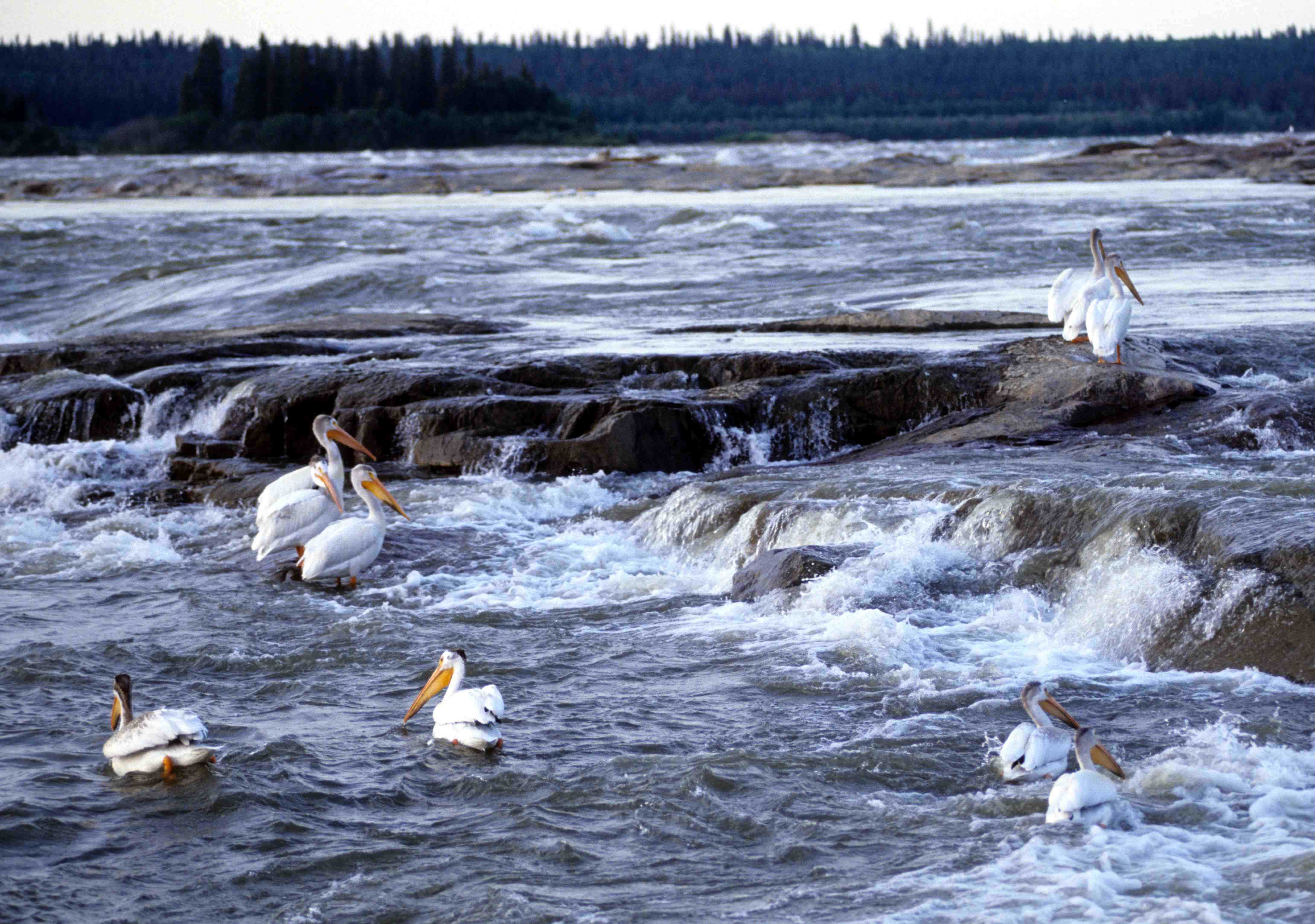
In the summer months, pelicans can be seen nesting on the various rapids near Fort Smith. Whooping cranes, an endangered species, also nest in the area during the summer and can be viewed via air charters as ground access is prohibited.
Education
There are a number of educational facilities in Fort Smith including Joseph Burr Tyrrell Elementary School, Paul William Kaeser High School and the Thebacha Campus of Aurora College.{{cite web | access-date = 2014-02-14}} Additionally, the main office of the South Slave Divisional Education Council is located in the town.{{cite web | access-date = 2014-02-14}}
Notable residents
- Mark Carney, 24th Prime Minister of Canada, former governor of the Bank of Canada and the Bank of England.
Notes
References
References
- {{Cite cgndb. LAILN. Fort Smith
- (September 2011). "Town of Fort Smith News (Volume 22)". Town of Fort Smith.
- {{MACANT. fort-smith. Fort Smith. 13 January 2014
- "Northwest Territories Official Community Names and Pronunciation Guide". Education, Culture and Employment, Government of the Northwest Territories.
- {{CFS
- "Fort Smith - Statistical Profile (2008-2019)". NWT Bureau of Statistics.
- Fort Smith (N.W.T.). Tourism Committee. (1979). "On the Banks of the Slave : a History of the Community of Fort Smith, Northwest Territories". Tourism Committee.
- [https://books.google.com/books?id=bp4xWM7K-FYC&dq=first+bank+fort+smith+nwt&pg=PA434 As Long as this Land Shall Last: A History of Treaty 8 and Treaty 11, 1870-1939]
- [http://www.rbc.com/history/quicktofrontier/union_bank_can-detail.html Union Bank of Canada, Fort Smith, North West Territories, 1921]
- ''On the Banks of the Slave: A History of the Community of Fort Smith, Northwest Territories''. Tourism Committee of Fort Smith, Department of Education Northwest Territories, 1979.
- "Map of Wood Buffalo National Park". Government of Canada.
- (March 31, 1954). "Ninth Census of Canada, 1951". [[Statistics Canada.
- (March 8, 1963). "1961 Census of Canada". [[Statistics Canada.
- (July 1973). "1971 Census of Canada". [[Statistics Canada]].
- (June 1977). "1976 Census of Canada: Population - Geographic Distributions". [[Statistics Canada]].
- (May 1992). "1981 Census of Canada: Census subdivisions in decreasing population order". [[Statistics Canada]].
- (September 1987). "1986 Census: Population - Census Divisions and Census Subdivisions". [[Statistics Canada]].
- (April 1992). "91 Census: Census Divisions and Census Subdivisions - Population and Dwelling Counts". [[Statistics Canada]].
- (April 1997). "96 Census: A National Overview - Population and Dwelling Counts". [[Statistics Canada]].
- (August 15, 2012). "Population and Dwelling Counts, for Canada, Provinces and Territories, and Census Subdivisions (Municipalities), 2001 and 1996 Censuses - 100% Data (Northwest Territories)". [[Statistics Canada]].
- (August 20, 2021). "Population and dwelling counts, for Canada, provinces and territories, and census subdivisions (municipalities), 2006 and 2001 censuses - 100% data (Northwest Territories)". [[Statistics Canada]].
- (March 4, 2014). "Corrections and updates: Population and dwelling count amendments, 2011 Census". [[Statistics Canada]].
- (February 8, 2017). "Census Profile, 2016 Census Fort Smith, Town [Census subdivision], Northwest Territories and Region 5, Region [Census division], Northwest Territories". [[Statistics Canada]].
- (August 2, 2024). "Census Profile, 2021 Census of Population Profile table Fort Smith, Town (T) Northwest Territories [Census subdivision] & Fort Smith Northwest Territories [Population centre]". [[Statistics Canada]].
- [https://www.statsnwt.ca/population/population-estimates/commtotals_2001-2017.xlsx Population Estimates By Community] from the GNWT
- Government of Canada, Statistics Canada. (2021-10-27). "Census Profile, 2016 Census".
- Government of Canada, Statistics Canada. (2015-11-27). "NHS Profile".
- Government of Canada, Statistics Canada. (2019-08-20). "2006 Community Profiles".
- Government of Canada, Statistics Canada. (2019-07-02). "2001 Community Profiles".
- "Official Voting Results Raw Data (poll by poll results in Fort Smith)". Elections Canada.
- "Mayor and Council". Fortsmith.ca.
- "Salt River First Nation". Srfn195.com.
- "First Nation Profiles Akaitcho Territory Government".
- (2008-09-05). "Akaitcho Territory Government". Daair.gov.nt.ca.
- (2012-06-30). "Salt River parting from Akaitcho First Nation". Cbc.ca.
- "Northwest Territory Métis Nation". Nwtmetisnation.ca.
- "Town of Fort Smith (attractions)".
- (2012-11-26). "UK Treasury Press Release". Hm-treasury.gov.uk.
- Tunney, Catharine. (9 March 2025). "Liberal Party chooses Mark Carney as new leader". [[CBC News]].
This article was imported from Wikipedia and is available under the Creative Commons Attribution-ShareAlike 4.0 License. Content has been adapted to SurfDoc format. Original contributors can be found on the article history page.
Ask Mako anything about Fort Smith, Northwest Territories — get instant answers, deeper analysis, and related topics.
Research with MakoFree with your Surf account
Create a free account to save articles, ask Mako questions, and organize your research.
Sign up freeThis content may have been generated or modified by AI. CloudSurf Software LLC is not responsible for the accuracy, completeness, or reliability of AI-generated content. Always verify important information from primary sources.
Report