From Surf Wiki (app.surf) — the open knowledge base
Fort Erie, Ontario
Town in Ontario, Canada
Town in Ontario, Canada
| Field | Value |
|---|---|
| name | Fort Erie |
| official_name | Town of Fort Erie |
| settlement_type | Town (lower-tier) |
| image_skyline | Fort Erie, Ontario (2013).jpg |
| image_caption | Fort Erie |
| pushpin_map | CAN ON Niagara#Canada Southern Ontario |
| coordinates | |
| subdivision_type | Country |
| subdivision_name | Canada Canada |
| subdivision_type1 | Province |
| subdivision_type2 | Regional Municipality |
| subdivision_name1 | Ontario Ontario |
| subdivision_name2 | Niagara |
| established_title | Established |
| leader_title | Mayor |
| leader_name | Wayne Redekop |
| leader_title1 | Governing body |
| leader_name1 | Fort Erie Town Council |
| unit_pref | Metric |
| area_footnotes | |
| area_land_km2 | 166.27 |
| elevation_footnotes | tags-- |
| population_total | 30710 |
| population_as_of | 2016 |
| population_footnotes | |
| population_density_km2 | 184.7 |
| postal_code_type | Forward Sortation Area |
| postal_code | L2A, L0S 1B0, 1N0, 1R0, 1S0, 1S1 |
| area_codes | 905, 289, 365, and 742 |
| website | www.forterie.ca |
| leader_title2 | MP |
| leader_name2 | Fred Davies |
| leader_title3 | MPP |
| leader_name3 | Wayne Gates |
| timezone | EST |
| utc_offset | -5 |
| timezone_DST | EDT |
| utc_offset_DST | -4 |
| blank_name | Highways |
| blank_info | |
the town in Ontario
Fort Erie is a town in the Niagara Region of Ontario, Canada. The town is located at the south eastern corner of the region, on the Niagara River, directly across the Canada–United States border from Buffalo, New York, and is the site of Old Fort Erie which played a prominent role in the War of 1812.
Fort Erie is one of Niagara's fastest growing communities, and has experienced a high level of residential and commercial development in the past few years. Garrison Road (Niagara Regional Road 3) is the town's commercial corridor, stretching east to west through Fort Erie.
Fort Erie is also home to other commercial core areas (Bridgeburg, Ridgeway, Stevensville and Crystal Beach) as a result of the 1970 amalgamation of Bertie Township and the village of Crystal Beach with Fort Erie.
Crystal Beach Park occupied waterfront land at Crystal Beach, Ontario, from 1888 until the park's closure in 1989. The beach is part of Fort Erie.
History
During the American Revolution Fort Erie was used as a supply depot for British troops. After the war the territory of what is now the Town of Fort Erie was settled by soldiers demobilised from Butler's Rangers, and the area was named Bertie Township in 1784.
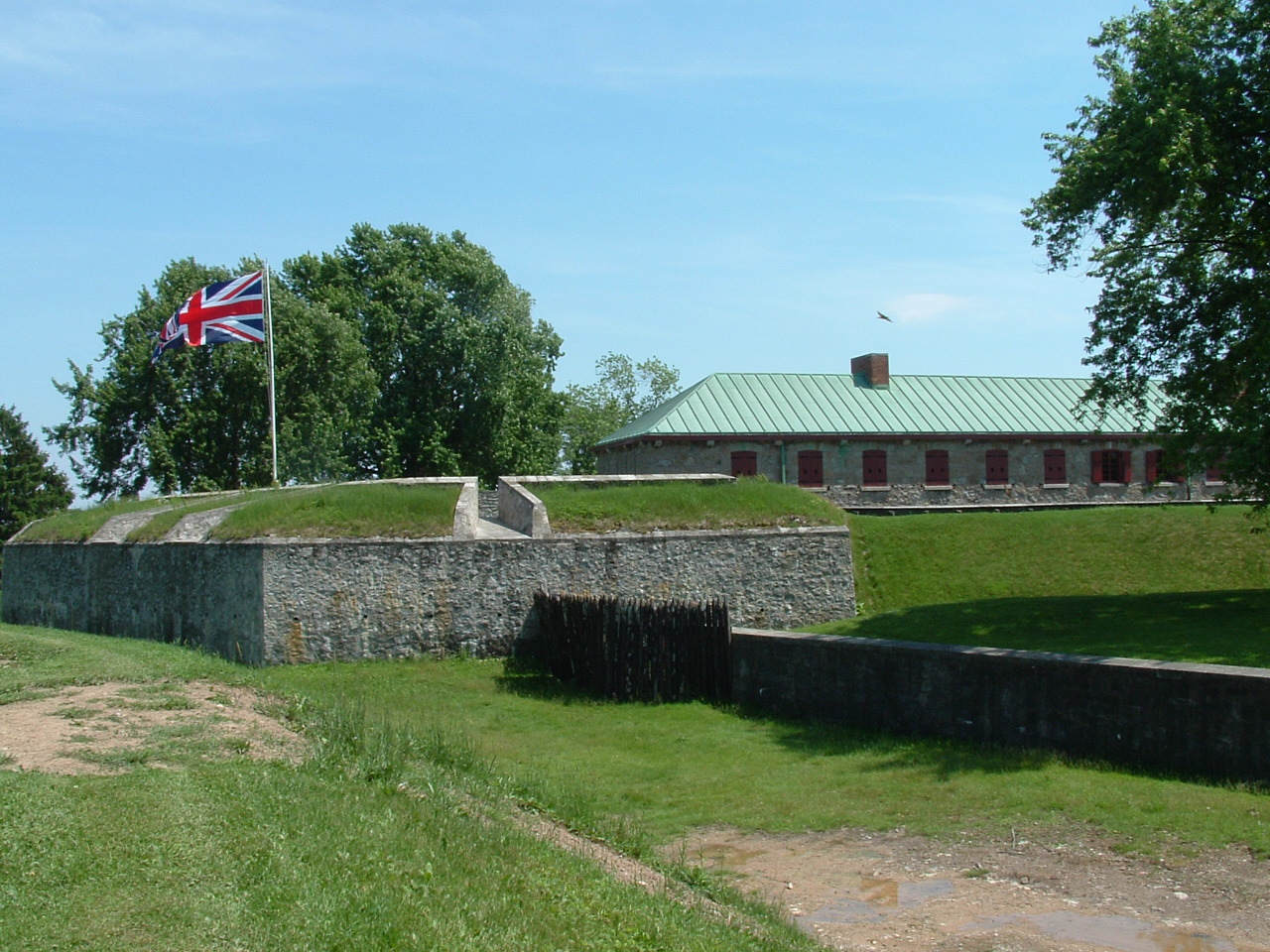
The original fort, built in 1764, was located on the Niagara River's edge below the present fort. It served as a supply depot and a port for ships transporting merchandise, troops and passengers via Lake Erie to the Upper Great Lakes. The fort was damaged by winter storms and in 1803, plans were made for a new fort on the higher ground behind the original. It was larger and made of flintstone but was not quite finished at the start of the War of 1812.
During the war, the Americans attacked Fort Erie twice in 1812, captured and abandoned it in 1813, and then recaptured it in 1814. The Americans held it for a time, breaking a prolonged British siege. Later they destroyed Fort Erie and returned to Buffalo in the winter of 1814.

While it was believed for many years that Fort Erie, particularly Bertie Hall, was an important stopping point on the Underground Railroad, there is no evidence of this being true. After a thorough investigation by Niagara Parks, no historical records were found that agreed with the local legend. The plaques which commemorated the false history were removed in 2021.
In 1866, during the Fenian raids, between 1,000 and 1,500 Fenians crossed the Niagara River, occupied the town and demanded food and horses. The only payment they were able to offer was Fenian bonds; these were not acceptable to the citizens. The Fenians then cut the telegraph wires and tore up some railway tracks. Afterwards, they marched to Chippewa and the next day to Ridgeway where they fought the Battle of Ridgeway, a series of skirmishes with the Canadian militia. The Fenians then returned to Fort Erie and fought the Battle of Fort Erie, defeating the Canadian militia. Fearing British reinforcements, they then decided to retreat to the U.S.
In 1869 the population was 1,000 and Fort Erie was served by the Grand Trunk and the Erie & Niagara railways. The Grand Trunk Railway built the International Railway Bridge in 1873, bringing about a new town, originally named Victoria and subsequently renamed to Bridgeburg, north of the original settlement of Fort Erie. By 1876, Ridgeway had an estimated population of 800, the village of Fort Erie has an estimated population of 1,200, and Victoria boasted three railway stations. By 1887, Stevensville had an estimated population of "nearly 600", Victoria of "nearly 700", Ridgeway of "about 600", and Fort Erie of "about 4,000".
In 1888, the amusement park at Crystal Beach opened. From 1910, the steamship (and until 1929, the steamship SS Americana) brought patrons from Buffalo until 1956. The park continued to operate until it closed in 1989. A gated community was built in this area.

In 1904, a group of speculators bought land at Erie Beach, planning to build an amusement park and other amenities, and sell lots around the park to vacationers from Buffalo. Erie Beach featured a hotel, a casino, a race track, regular ferry service from Buffalo and train service from the ferry dock in Fort Erie, and what was billed as the world's largest outdoor swimming pool. Erie Beach and Crystal Beach were in competition to provide bigger thrills to patrons, until Erie Beach went bankrupt during the Depression and closed down on Labour Day weekend, 1930.
The Niagara Movement meeting was held at the Erie Beach Hotel in 1905. The movement later led to the founding of the NAACP.
The Point Abino Light Tower was built by the Canadian government in 1918. The lighthouse has been automated in 1989. Since its decommissioning in 1995, the Point Abino Lighthouse was designated as a National Historic Site. The lighthouse is now owned by the Town of Fort Erie and is available for weekend tours in the summer.
On August 7, 1927, the Peace Bridge was opened between Fort Erie and Buffalo.
On January 1, 1932, Bridgeburg and Fort Erie amalgamated into a single town.
The ruins of Fort Erie remained until they were rebuilt through a depression era "work program" project, as a tourist attraction. Work started in 1937, and the fort was opened to the public in 1939.
In 1970, the provincial government consolidated the various villages in what had been Bertie Township, including the then town of Fort Erie, into the present Town of Fort Erie.
Geography
Fort Erie is optimally flat, but there are low sand hills, varying in height from 2 to, along the shore of Lake Erie, and a limestone ridge extends from Point Abino to near Miller's Creek, giving Ridgeway its name. The soil is shallow, with a clay subsoil.
The town's beaches on Lake Erie, most notably Erie Beach, Crystal Beach and Bay Beach are considered the best in the area and draw many weekend visitors from the Toronto and Buffalo, New York areas. While summers are enjoyable, winters can occasionally be fierce, with many snowstorms, whiteouts and winds coming off Lake Erie.
Communities
In addition to the primary urban core of Fort Erie, the town also contains the neighbourhoods of Black Creek, Bridgeburg/NorthEnd/Victoria, Crescent Park, Crystal Beach, Kraft, Point Abino, Ridgeway, Snyder, and Stevensville. Smaller and historical neighbourhoods include Amigari Downs, Bay Beach, Buffalo Heights, Douglastown, Edgewood Park, Erie Beach, Garrison Village, Mulgrave, Oakhill Forest, Ridgemount, Ridgewood, Rose Hill Estates, Thunder Bay, Walden, Wavecrest and Waverly Beach.
Fort Erie Secondary School and Ridgeway-Crystal Beach High School were two public high schools serving Fort Erie and area communities until September 2017. The two former schools were closed and merged into Greater Fort Erie Secondary School, located on Garrison Road.
Climate
|Jan record high C = 15.5 |Feb record high C = 19.5 |Mar record high C = 27.0 |Apr record high C = 32.0 |May record high C = 32.0 |Jun record high C = 34.0 |Jul record high C = 34.5 |Aug record high C = 35.5 |Sep record high C = 32.5 |Oct record high C = 29.5 |Nov record high C = 25.0 |Dec record high C = 18.0 |year record high C = 35.5 |Jan record low C = −28.5 |Feb record low C = −31.0 |Mar record low C = −25.5 |Apr record low C = −12.0 |May record low C = −4.5 |Jun record low C = 1.0 |Jul record low C = 5.5 |Aug record low C = 1.5 |Sep record low C = −1.0 |Oct record low C = −6.1 |Nov record low C = −15.5 |Dec record low C = −24.5 |year record low C = −31.0 | access-date = Mar 23, 2025}}
Demographics
|1871| 835 |1901| 890 |1911| 1146 |1921| 1546 |1931| 2383 |1941| 6566 |1951| 7572 |1961| 9027 |1971| 23113 |1981| 24096 |1991| 26006 |2001| 28143 |2006| 29925 |2011| 29960 |2016| 30710 |2021| 32901
In the 2021 Census of Population conducted by Statistics Canada, Fort Erie had a population of living in of its total private dwellings, a change of from its 2016 population of . With a land area of 166.24 km2, it had a population density of in 2021.
The median household income in 2015 for Fort Erie was $60,800, which was below the Ontario provincial average of $74,287.
| Canada 2006 Census | Population | % of Total Population | |
|---|---|---|---|
| Visible minority groupSource: | South Asian | 225 | |
| Chinese | 365 | ||
| Black | 300 | ||
| Filipino | 50 | ||
| Latin American | 410 | ||
| Arab | 40 | ||
| Southeast Asian | 45 | ||
| West Asian | 30 | ||
| Korean | 85 | ||
| Japanese | 20 | ||
| Other visible minority | 35 | ||
| Mixed visible minority | 20 | ||
| Total visible minority population | 1,620 | **** | |
| Aboriginal groupSource: | First Nations | 750 | |
| Métis | 150 | ||
| Inuit | 0 | ||
| Total Aboriginal population | 900 | **** | |
| White | 26,985 | ||
| *Total population* | *29,545* | *100%* |
Government
The Town Council consists of the Mayor and 6 ward councillors.
Town Council and municipal services are based at Town Hall at 1 Municipal Drive since 1996. The previous location at 200 Jarvis Street was used after the first town hall was vacated in 1985 and was home to Bridgeburg Town Hall. The first town hall is now a parking lot, with the World War 1 memorial moved to Mathers Park, and the second town hall is replaced by the Fort Erie Courthouse.
Fort Erie has a single member on Niagara Regional Council.
Attractions
- Fort Erie Race Track
- Old Fort Erie
- Point Abino Lighthouse
- Safari Niagara
Hiking
Fort Erie is the eastern terminus of the Friendship Trail, and the southern terminus of the Niagara River Recreation Pathway. Both trails are part of the Trans-Canada Trail system.
Parks
Mather Arch Park, located just to the south of the Peace Bridge, is on land donated by American citizen Alonzo C. Mather in tribute to the peace and friendship between Canada and the United States. The park contains Mather Arch, which was built largely due to donations by Mather, originally dedicated by the Niagara Parks Commission in 1939, and restored in 2000 as a millennium project. There is also a memorial statue to those from Fort Erie who died in World War I, World War II, and the Korean War.
Sports
| Team | League | Sport | Venue | Established | Championships |
|---|---|---|---|---|---|
| Fort Erie Meteors | Greater Ontario Junior Hockey League | Ice hockey | Fort Erie Leisureplex | 1957 | 0 (1 in previous leagues) |
| Fort Erie Cannons | Niagara District Baseball Association | Baseball | Oakes Park | 2005 | 2 |
Infrastructure
Transportation
Highways
Fort Erie has been the Niagara terminus of the Queen Elizabeth Way since 1937. Road traffic continues to Buffalo, New York across the Peace Bridge, which was built in 1927.
Fort Erie was the eastern terminus of King's Highway 3A from 1927 to 1929, and Ontario Highway 3 from 1929 until 1998, when the portion of Highway 3 within Fort Erie was downloaded to the Regional Municipality of Niagara and redesignated as Niagara Regional Road 3. Within Fort Erie, Highway 3 is named Garrison Road, and is the major east–west connection through the town. Dominion Road was designated as King's Highway 3C from 1934 until 1970, when it was downloaded to the newly formed Regional Municipality of Niagara and redesignated as Niagara Regional Road 1.
Fort Erie is the southern terminus of the Niagara Parkway, which extends from Fort Erie to Fort George.
Public transit
Public transit was provided by Fort Erie Transit, which operated buses in town and connected to other Niagara municipalities.
Niagara Region Transit operates a service from Niagara Falls into Fort Erie, connecting with the Fort Erie Leisureplex on Garrison Road.
Intercity transit
Private intercity coach services are primarily operated by Coach Canada/Megabus, with service to St. Catharines and Toronto. The terminus is located at Robo Mart, 21 Princess Street at Waterloo Street.
The International Railway Bridge was built in 1873, and connects Fort Erie to Buffalo, New York across the Niagara River.
There is currently no passenger rail service to Fort Erie. The nearest passenger rail stations are in Buffalo, New York and Niagara Falls, Ontario.
Waterways
Fort Erie is at the outlet of Lake Erie into the Niagara River. The lake and river serve as a playground for numerous personal yachts, sailboats, power boats and watercraft. There is a marina at the site of a former shipyard at Miller's Creek on the Niagara River, and a boat launch ramp in Crystal Beach.
Prior to the completion of the two bridges, passengers and freight were carried across the river by ferry.
From 1829, when the Welland Canal first opened, to 1833, when the cut was completed to Port Colborne, ship traffic between Lake Erie and Lake Ontario would transit the upper Niagara River.
Utilities
In order to reduce large-scale ice blockage in the Niagara River, with resultant flooding, ice damage to docks and other waterfront structures, and blockage of the water intakes for the hydro-electric power plants at Niagara Falls, the New York Power Authority and Ontario Power Generation have jointly operated the Lake Erie-Niagara River Ice Boom since 1964. The boom is installed on December 16, or when the water temperature reaches 4 C, whichever happens first. The boom is opened on April 1 unless there is more than 650 km2 of ice remaining in Eastern Lake Erie. When in place, the boom stretches 2,680 m from the outer breakwall at Buffalo Harbor almost to the Canadian shore near the ruins of the pier at Erie Beach in Fort Erie. Originally, the boom was made of wooden timbers, but these have been replaced by steel pontoons.
Notable people
- Randy Burridge, played over 700 games in the National Hockey League and was an All-Star in 1992
- Derek Clendening, Canadian writer
- Ernest Alexander Cruikshank, Brigadier General and historian
- Billy Dea, professional hockey player
- Michael Fonfara, keyboard player
- Paul Gardner, professional hockey player
- Paul Hellyer, engineer and politician
- Tim Hudak, politician, leader of the PC party in Ontario
- Douglas Kirkland, photographer
- James L. Kraft, entrepreneur and inventor
- Dan "DJ Shub" General, musician
- Shane Lindstrom (professionally known as Murda Beatz), record producer
- Matty Matheson, chef and internet personality
- Pierre Pilote, professional hockey player
- David Anthony Pizzuto, actor
- Brian Reid, historian
References
References
- [http://www12.statcan.gc.ca/census-recensement/2016/dp-pd/prof/details/page.cfm?Lang=E&Geo1=CSD&Code1=3526003&Geo2=PR&Code2=35&Data=Count&SearchText=Fort%20Erie&SearchType=Begins&SearchPR=01&B1=All&GeoLevel=PR&GeoCode=3526003&TABID=1 2016 Census Profile]
- "Crystal Beach".
- "Old Fort Erie History". Niagara Parks Commission.
- (2011). "Places of the Underground Railroad: A Geographical Guide". ABC-CLIO.
- Calarco, Tom. (2014). "The Search for the Underground Railroad". The History Press.
- (25 November 2021). "New Plaque In Front of Bertie Hall: A Local History Lesson, Updated".
- (2 September 2021). "Final remnant of Fort Erie’s false Black history removed".
- "The Fenian Raid 1866". The Queen's Own Rifles.
- (23 February 2012). "The Fenian Raid 1866". The Queen's Own Rifles of Canada Regimental Museum and Archives.
- For the figure of 850, see: H.W. Hemans to Lord Monck, telegram June 3, 1866, in [s.n.] ''Correspondence Relating to the Fenian Invasion and Rebellion of the Southern States'', Ottawa: 1869. p. 142; also Colonel Lowry, Report, June 4, 1866, ''Miscellaneous Records Relating to the Fenian Raids'', British Military and Naval Records "C" Series, RG8-1, Volume 1672; Microfilm reel C-4300, p. 282. (Public Archives of Canada)
- [https://sites.google.com/site/niagarasettlers2/bertie-township-abstracts Bertie Township]
- [https://sites.google.com/site/townshippapers/bertie-township-papers The Township Papers of Bertie Township, Welland County]
- "Crystal Beach Amusement Park".
- "S.S. Canadiana Facts".
- "Erie Beach Amusement Park".
- "Niagara Movement First Annual Meeting". University of Massachusetts.
- (September 5, 2017). "Smooth Start As Two High Schools Become One". District School Board of Niagara.
- (February 9, 2022). "Population and dwelling counts: Canada, provinces and territories, census divisions and census subdivisions (municipalities), Ontario". [[Statistics Canada]].
- (8 February 2017). "Fort Erie, Ontario - Income Profile".
- (13 March 2007). "Community Profiles from the 2006 Census". Statistics Canada - Census Subdivision.
- "Aboriginal Peoples - Data table". Statistics Canada.
- "About - Safari Niagara". Safari Niagara.
- "Historic Plaques & Markers". Niagara Park Commission.
- "Fort Erie Transit". Town of Fort Erie.
- "Leisureplex Fort Erie Bus Stop". Niagara Region.
- (November 1999). "Lake Erie–Niagara River Ice Boom Information Sheet". The International Niagara Board of Control of the International Joint Commission.
This article was imported from Wikipedia and is available under the Creative Commons Attribution-ShareAlike 4.0 License. Content has been adapted to SurfDoc format. Original contributors can be found on the article history page.
Ask Mako anything about Fort Erie, Ontario — get instant answers, deeper analysis, and related topics.
Research with MakoFree with your Surf account
Create a free account to save articles, ask Mako questions, and organize your research.
Sign up freeThis content may have been generated or modified by AI. CloudSurf Software LLC is not responsible for the accuracy, completeness, or reliability of AI-generated content. Always verify important information from primary sources.
Report