From Surf Wiki (app.surf) — the open knowledge base
Flathead County, Montana
County in Montana, United States
County in Montana, United States
| Field | Value |
|---|---|
| county | Flathead County |
| state | Montana |
| seal | Flathead County mt seal.jpg |
| founded year | 1893 |
| seat wl | Kalispell |
| largest city wl | Kalispell |
| area_total_sq_mi | 5256 |
| area_land_sq_mi | 5088 |
| area_water_sq_mi | 169 |
| area percentage | 3.2 |
| population_as_of | 2020 |
| population_total | 104357 |
| pop_est_as_of | 2024 |
| population_est | 114527 |
| population_density_sq_mi | auto |
| time zone | Mountain |
| web | flathead.mt.gov |
| ex image | Flathead County Courthouse July 2020.jpg |
| ex image cap | Flathead County Courthouse in Kalispell |
| district | 1st |
| named for | Flathead Indians |
- Montana county number 07
Flathead County is a county located in the U.S. state of Montana. At the 2020 census, its population was 104,357, making it the state's fourth most populous county. Its county seat is Kalispell. Its numerical designation (used in the issuance of license plates) is 7. Its northern border is on the state's north border, making it contiguous with the Canada–US border, facing British Columbia.
Flathead County comprises the Kalispell, Montana Micropolitan Statistical Area, with neighboring Lake County following soon after.
History
Flathead County was founded in 1893. Some sources cite the supposed practice of the Salish tribe flattening infants' heads as the origin of the name Flathead, but there is no record of Salish Indians ever having that appearance.
Geography
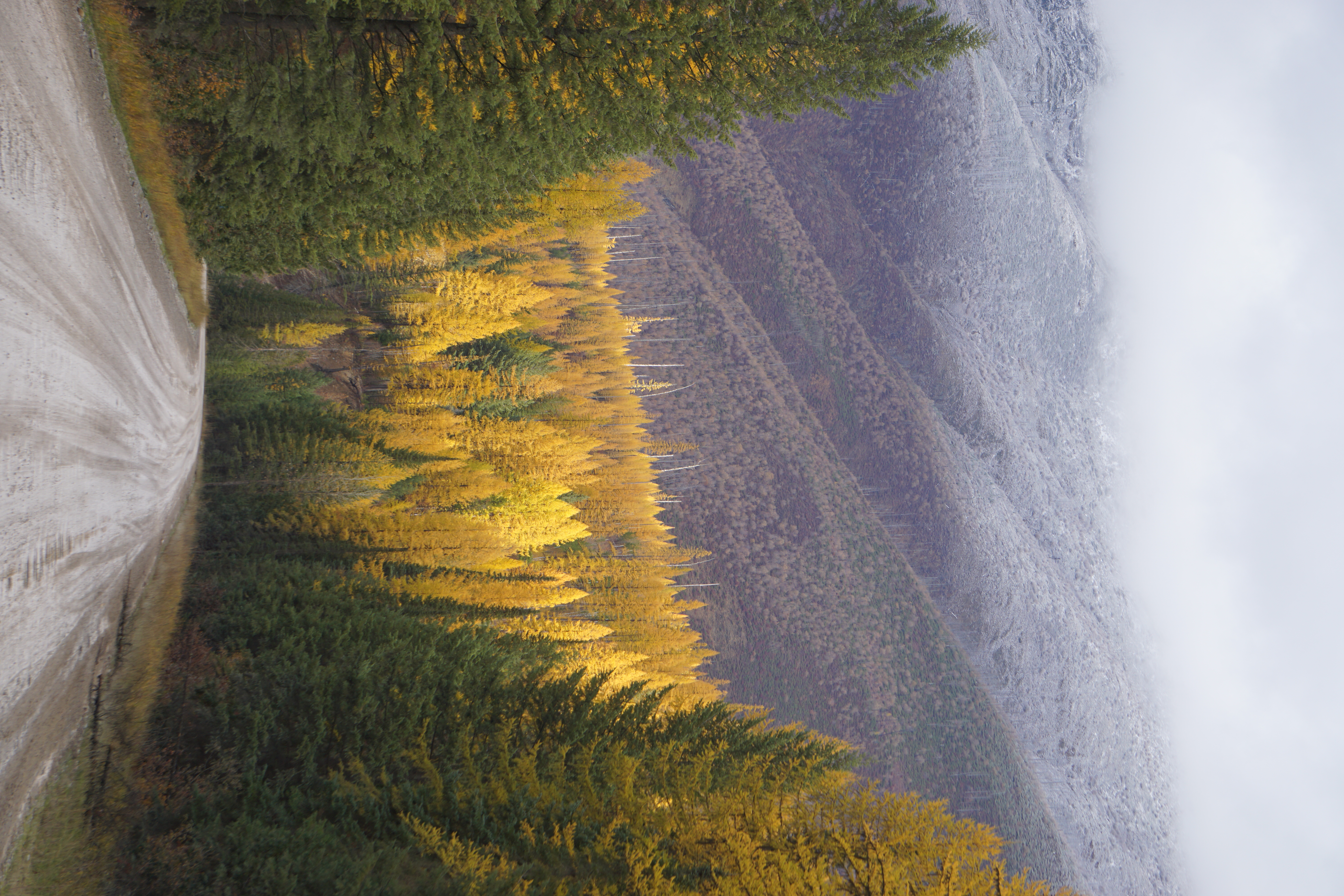
The county includes much of Flathead Lake, the Flathead Valley, and the Flathead River. These natural treasures were created by glacial activity which ended approximately 10,000 years ago. The Flathead Valley is the southern extension of a prominent valley called the Rocky Mountain Trench, which runs from the Yukon Territory in Canada as far south as Flathead Lake. The Trench in northwestern Montana was created by subsidence along a major extensional fault, which continues today. After the valley formed, glaciers flowing down the Trench from British Columbia, and into it from the surrounding mountain ranges left a flat valley floor and dammed the Flathead River drainage to create Flathead Lake. Several tribes have long used the Flathead Lake, and the Bitterroot Salish, Kootenai, and Pend d'Oreilles tribes are represented on the Flathead Reservation. The western part of Glacier National Park is located in the county.
According to the United States Census Bureau, the county has a total area of 5256 sqmi, of which 5088 sqmi is land and 169 sqmi (3.2%) is water. It is the third-largest county in Montana by land area and second-largest by total area.
Ecology
Wildlife includes bobcats, black bears, coyotes, deer, elk, grizzly bears, lynx, mountain lions, and wolves.
National protected areas
- Pacific Northwest National Scenic Trail (part)
- Flathead National Forest (part)
- Glacier National Park (part)
- Kootenai National Forest (part)
- Lolo National Forest (part)
- Lost Trail National Wildlife Refuge
Demographics
|align-fn=center 1790–1960 1900–1990 1990–2000 2010–2020
2020 census
As of the 2020 census, the county had a population of 104,357. Of the residents, 21.9% were under the age of 18 and 21.4% were 65 years of age or older; the median age was 42.9 years. For every 100 females there were 99.3 males, and for every 100 females age 18 and over there were 96.9 males. 48.5% of residents lived in urban areas and 51.5% lived in rural areas.
The racial makeup of the county was 90.7% White, 0.3% Black or African American, 0.9% American Indian and Alaska Native, 0.7% Asian, 1.0% from some other race, and 6.4% from two or more races. Hispanic or Latino residents of any race comprised 3.2% of the population.
There were 42,481 households in the county, of which 27.2% had children under the age of 18 living with them and 22.8% had a female householder with no spouse or partner present. About 27.2% of all households were made up of individuals and 12.7% had someone living alone who was 65 years of age or older.
There were 49,875 housing units, of which 14.8% were vacant. Among occupied housing units, 71.7% were owner-occupied and 28.3% were renter-occupied. The homeowner vacancy rate was 1.5% and the rental vacancy rate was 6.6%.
2010 census
As of the 2010 census, there were 90,928 people, 37,504 households, and 24,817 families living in the county. The population density was 17.9 PD/sqmi. There were 46,963 housing units at an average density of 9.2 /sqmi. The racial makeup of the county was 95.5% white, 1.1% American Indian, 0.6% Asian, 0.2% black or African American, 0.1% Pacific islander, 0.4% from other races, and 2.1% from two or more races. Those of Hispanic or Latino origin made up 2.3% of the population. In terms of ancestry, 28.1% were German, 15.0% were English, 14.8% were Irish, 9.3% were Norwegian, and 4.6% were American.
Of the 37,504 households, 29.5% had children under the age of 18 living with them, 52.8% were married couples living together, 8.7% had a female householder with no husband present, 33.8% were non-families, and 27.2% of all households were made up of individuals. The average household size was 2.40, and the average family size was 2.91. The median age was 41.2 years.
The median income for a household in the county was $44,998, and the median income for a family was $53,940. Males had a median income of $39,767 versus $28,026 for females. The per capita income for the county was $24,721. About 8.4% of families and 11.7% of the population were below the poverty line, including 17.8% of those under age 18 and 7.7% of those age 65 or over.
Politics
Along with Yellowstone County (home to Billings), Flathead County is one of Montana's more populous counties that leans heavily Republican. It has last voted Democratic in 1964, and has voted over 60% Republican in every presidential election since 1996 save 2008.
Infrastructure
- Kalispell Regional Medical Center is the county's largest hospital.
- North Valley Hospital is located in Whitefish
Flathead County Library System has 4 locations:
- Whitefish Library is separate
- 3 County Commissioner Districts
- 11 House Districts
- 7 Senate Districts
Communities
Cities
- Columbia Falls
- Kalispell (county seat)
- Whitefish
Census-designated places
- Batavia
- Bigfork
- Coram
- Essex
- Evergreen
- Forest Hill Village
- Helena Flats
- Hungry Horse
- Kila
- Lakeside
- Little Bitterroot Lake
- Marion
- Martin City
- Niarada
- Olney
- Pinnacle
- Polebridge
- Rhodes
- Snowslip
- Somers
- West Glacier
Other unincorporated communities
- Apgar Village
- Lake McDonald
Adjacent counties
- Regional District of East Kootenay, British Columbia – north
- Waterton Lakes National Park (Improvement District No. 4), Alberta – northeast
- Glacier County – east
- Pondera County – east
- Teton County – east
- Lewis and Clark County – southeast
- Powell County – southeast
- Missoula County – southeast
- Lake County – south
- Sanders County – southwest
- Lincoln County – west
Education
High school districts include:
- Bigfork High School District
- Columbia Falls High School District
- Flathead High School District
- Whitefish High School District
Elementary school districts include:
- Bigfork Elementary School District
- Cayuse Prairie Elementary School District
- Columbia Falls Elementary School District
- Creston Elementary School District
- Deer Park Elementary School District
- Fair-Mont-Egan Elementary School District
- Evergreen Elementary School District
- Helena Flats Elementary School District
- Kalispell Elementary School District
- Kila Elementary School District
- Marion Elementary School District
- Olney-Bissell Elementary School District
- Pleasant Valley Elementary School District
- Smith Valley Elementary School District
- Somers Elementary School District
- Swan River Elementary School District
- West Glacier Elementary School District
- West Valley Elementary School District
- Whitefish Elementary School District
Flathead Valley Community College is a tertiary institution.
Notable people
- Joe Bereta, member of the sketch comedy duo Barats and Bereta based in Spokane, Washington. Currently co-hosts SourceFed on YouTube.
- Frank Hagel, Western art painter
- Phil Jackson, NBA coach and player
- Dorothy M. Johnson, writer of Westerns
- Daniel Parker, wildlife sculptor
- Maury Povich, talk show host known for his TV show Maury
- Keith Regier, Montana state senator
- Alice Ritzman, LPGA golf professional
- Derek Skees, Montana state representative
- Michelle Williams, actress
In popular culture
Miami Herald columnist Dave Barry frequently cites the police blotter of the Flathead Beacon in Flathead County as a source of humorous material. It is written in a spare, surrealist style by local man Micah Drew, following the pattern set by earlier writers Christie Burns and Justin Franz.
References
References
- "State & County QuickFacts". United States Census Bureau.
- "Find a County". National Association of Counties.
- Gannett, Henry. (1905). "The Origin of Certain Place Names in the United States". Govt. Print. Off..
- (August 22, 2012). "2010 Census Gazetteer Files". United States Census Bureau.
- Long, Ben. (March 6, 2020). "Finding a Middle Ground on Wolves and Wolf Management".
- "County Population Totals and Components of Change: 2020-2024". United States Census Bureau.
- "U.S. Decennial Census". United States Census Bureau.
- "Historical Census Browser". University of Virginia Library.
- "Population of Counties by Decennial Census: 1900 to 1990". United States Census Bureau.
- "Census 2000 PHC-T-4. Ranking Tables for Counties: 1990 and 2000". United States Census Bureau.
- (2021). "2020 Decennial Census Redistricting Data (Public Law 94-171)". United States Census Bureau.
- (2021). "2020 Decennial Census Demographic Profile (DP1)". United States Census Bureau.
- (2023). "2020 Decennial Census Demographic and Housing Characteristics (DHC)". United States Census Bureau.
- Leip, David. "Atlas of US Presidential Elections".
- The leading "other" candidate, [[Progressive Party (United States, 1924–34). Progressive]] [[Robert M. La Follette. Bob La Follette]], received 2,537 votes, while the [[Workers Party of America. Workers Party]] candidate [[William Z. Foster. William Foster]] received 5 votes.
- "2020 CENSUS - SCHOOL DISTRICT REFERENCE MAP: Flathead County, MT". [[U.S. Census Bureau]].
- Read, Richard. (October 24, 2020). "Coronavirus bears down on a small Montana town". Los Angeles Times.
This article was imported from Wikipedia and is available under the Creative Commons Attribution-ShareAlike 4.0 License. Content has been adapted to SurfDoc format. Original contributors can be found on the article history page.
Ask Mako anything about Flathead County, Montana — get instant answers, deeper analysis, and related topics.
Research with MakoFree with your Surf account
Create a free account to save articles, ask Mako questions, and organize your research.
Sign up freeThis content may have been generated or modified by AI. CloudSurf Software LLC is not responsible for the accuracy, completeness, or reliability of AI-generated content. Always verify important information from primary sources.
Report