From Surf Wiki (app.surf) — the open knowledge base
Finnmarksvidda
Norwegian plateau

Norwegian plateau
| Field | Value |
|---|---|
| name | Finnmarksvidda |
| native_name | se |
| type | Plateau |
| photo | SUC50562.JPG |
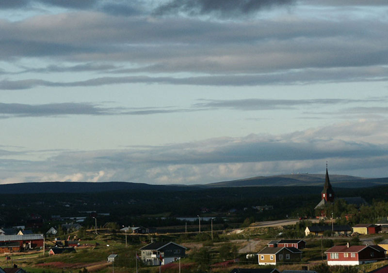
| photo_caption | The lowest elevations can be found in the eastern part of Finnmarksvidda, near Karasjok and Tana. River valleys in the area are only 100–250 m (300–800 ft) above sea level. |
| mapframe | yes |
| mapframe-zoom | 5 |
| mapframe-wikidata | yes |
| mapframe-caption | Interactive map of the lake |
| location | Finnmark, Norway |
| coordinates | |
| elevation | 300 to |
| area | 22000 km2 |
| mapframe-zoom = 5 | mapframe-wikidata = yes | mapframe-caption = Interactive map of the lake
Finnmarksvidda (; ) is Norway's largest plateau, with an area greater than 22000 km2. The plateau lies about 300 to above sea level. Approximately 36% of Finnmark lies on the Finnmarksvidda.
Geography
From Alta Municipality in the west to the Varanger Peninsula in the east it stretches for approximately 300 km, being at least that wide from north to south, extending into Finland. The southeastern part of the plateau is protected by the Anárjohka National Park. The 1409 km2 park opened in 1976.
Some circular lakes in Finnmarksvidda may be remnants of collapsed pingos that developed during cold periods of the last deglaciation.
Fauna and flora
The plateau includes extensive birch woods, pine barrens, bogs, and glacially formed lakes. Finnmarksvidda is situated north of the Arctic Circle and is best known as the land of the once nomadic Sami people and their reindeer herds. Their shelters in the tundra are still used in the winter time.
Climate
Finnmarksvidda, located in the interior of the county has a subarctic climate with the coldest winter temperatures in Norway: the coldest temperature ever recorded was -51.4 C in Karasjok on 1 January 1886. The climate of Kautokeino (307 m) represents the climate of the plateau.
Šihččajávri, 382m, is a weather station by the lake of the same name. It is situated high on the plateau and far inland, approximately 13 km from the E45 border crossing with Norway and Finland. | Jan record high C = 4.8 | Feb record high C = 5.6 | Mar record high C = 5.8 | Apr record high C = 12.8 | May record high C = 27.1 | Jun record high C = 34.3 | Jul record high C = 30.5 | Aug record high C = 28.8 | Sep record high C = 22.0 | Oct record high C = 13.0 | Nov record high C = 9.4 | Dec record high C = 5.5 | year record high C =
| Jan avg record high C = 0.8 | Feb avg record high C = 1.1 | Mar avg record high C = 2.7 | Apr avg record high C = 7.0 | May avg record high C = 16.1 | Jun avg record high C = 22.5 | Jul avg record high C = 23.6 | Aug avg record high C = 22.0 | Sep avg record high C = 16.2 | Oct avg record high C = 8.5 | Nov avg record high C = 2.2 | Dec avg record high C = 2.1 | year avg record high C = 25.1
| Jan avg record low C = -35.5 | Feb avg record low C = -34.3 | Mar avg record low C = -30.5 | Apr avg record low C = -24.2 | May avg record low C = -10.8 | Jun avg record low C = -1.1 | Jul avg record low C = 1.5 | Aug avg record low C = -2.1 | Sep avg record low C = -5.6 | Oct avg record low C = -18.1 | Nov avg record low C = -26.4 | Dec avg record low C = -31.7 | year avg record low C = -38.2
| Jan record low C = -45.5 | Feb record low C = -47.8 | Mar record low C = -42.6 | Apr record low C = -34.5 | May record low C = -24.5 | Jun record low C = -7.4 | Jul record low C = -3.2 | Aug record low C = -7.0 | Sep record low C = -15.4 | Oct record low C = -34.1 | Nov record low C = -38.9 | Dec record low C = -40.6 | year record low C =
| access-date = April 29, 2024}} |access-date= 11 Dec 2024}}
References
References
- "About Finnmark". Turistforeningen.
- Ryvarden, Leif. (2007). "Stabbursdalen, Øvre Pasvik og Øvre Anárjohka". Gyldendal.
- Svensson, Harald. (1976). "Pingo problems in the Scandinavian countries". [[Biuletyn Peryglacjalny]].
- "Stasjonsinformasjon". [[Norwegian Meteorological Institute]].
This article was imported from Wikipedia and is available under the Creative Commons Attribution-ShareAlike 4.0 License. Content has been adapted to SurfDoc format. Original contributors can be found on the article history page.
Ask Mako anything about Finnmarksvidda — get instant answers, deeper analysis, and related topics.
Research with MakoFree with your Surf account
Create a free account to save articles, ask Mako questions, and organize your research.
Sign up freeThis content may have been generated or modified by AI. CloudSurf Software LLC is not responsible for the accuracy, completeness, or reliability of AI-generated content. Always verify important information from primary sources.
Report