From Surf Wiki (app.surf) — the open knowledge base
Fayette County, Texas
County in Texas, United States

County in Texas, United States
| Field | Value |
|---|---|
| county | Fayette County |
| state | Texas |
| founded year | 1837 |
| seat wl | La Grange |
| largest city wl | La Grange |
| area_total_sq_mi | 960 |
| area_land_sq_mi | 950 |
| area_water_sq_mi | 9.8 |
| area percentage | 1.0 |
| census yr | 2020 |
| pop | 24435 |
| density_sq_mi | auto |
| time zone | Central |
| ex image | Fayette County La Grange Wiki (1 of 1).jpg |
| ex image size | 250 |
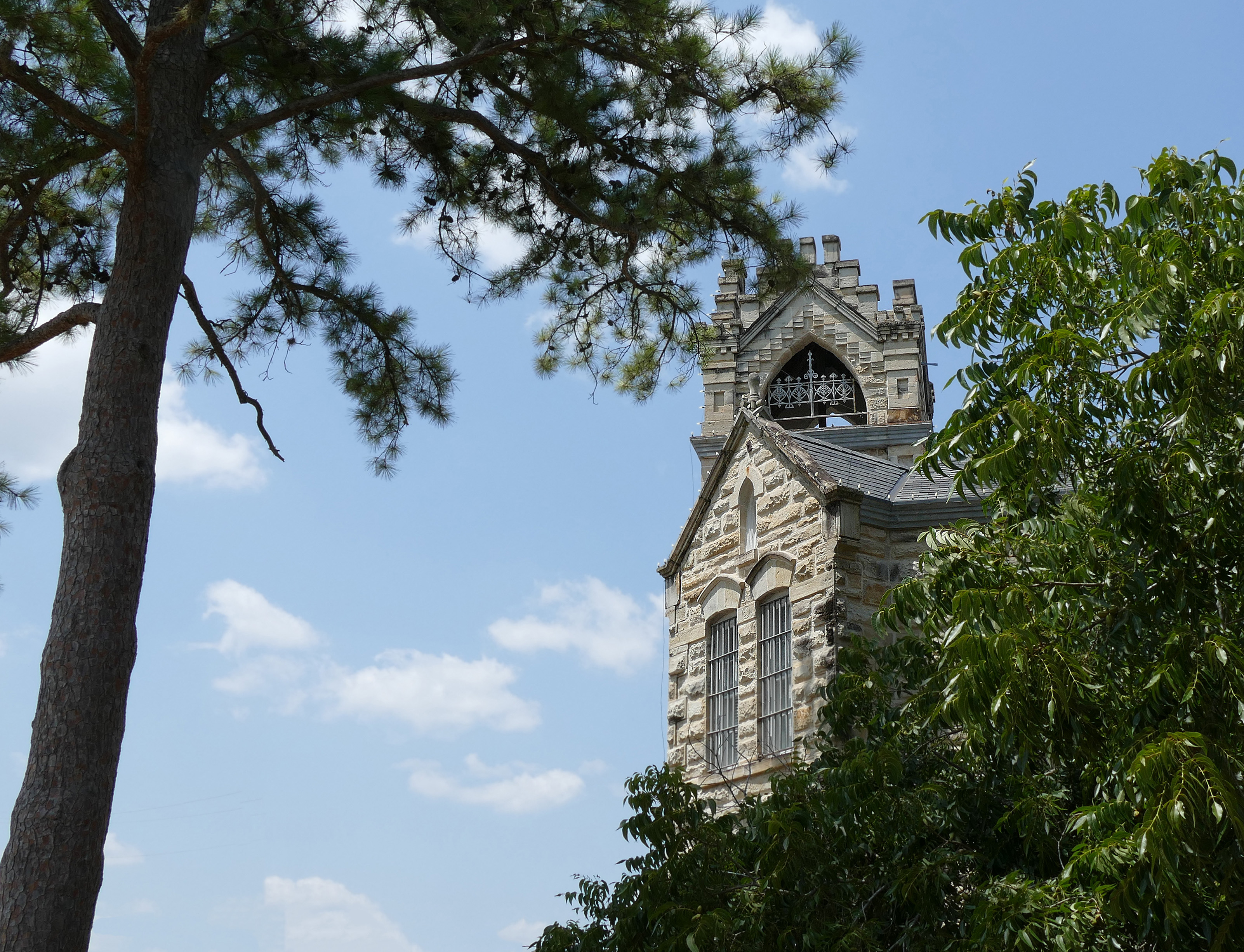
| ex image cap | The current Fayette County Courthouse in La Grange was finished in 1891. The Romanesque Revival-style building uses four types of native Texas stone to detail the exterior. |
| web | www.co.fayette.tx.us |
| named for | Marquis de la Fayette |
| district | 10th |
Fayette County is a county located in the U.S. state of Texas. As of the 2020 census, its population was 24,435. Its county seat is La Grange. The county was created in 1837 and organized the next year. Fayette County was settled by German and Czech emigrants in the mid 1830's. The county lies in the Texas German belt, a fragmented belt of German towns throughout central Texas.
History
Fayette County was established in 1837 from land given by Bastrop and Colorado Counties. It is named for the Marquis de Lafayette, a French nobleman who became an American Revolutionary War hero.
An early resident of Brazoria County and then Fayette County, Joel Walter Robison fought in the Texas Revolution and served in the Texas House of Representatives.{{cite web|url=https://tshaonline.org/handbook/online/articles/fro42
More than a dozen historic properties are listed on the National Register of Historic Places in Fayette County.
Fayette County is the location of the real Chicken Ranch, which was the basis of the musical play and feature film The Best Little Whorehouse in Texas.
Geography
According to the U.S. Census Bureau, the county has a total area of 960 sqmi, of which 9.8 sqmi (1.0%) are covered by water.
Adjacent counties
- Lee County (north)
- Washington County (northeast)
- Austin County (east)
- Colorado County (southeast)
- Lavaca County (south)
- Gonzales County (southwest)
- Caldwell County (west)
- Bastrop County (northwest)

Demographics
|align-fn=center 1850–2010 2010 2020
Racial and ethnic composition
| Race / Ethnicity (NH = Non-Hispanic) | title=P004: Hispanic or Latino, and Not Hispanic or Latino by Race – 2000: DEC Summary File 1 – Fayette County, Texas | url=https://data.census.gov/table?g=0500000US48149&tid=DECENNIALSF12000.P004 | website=United States Census Bureau | access-date= }} | title=P2 Hispanic or Latino, and Not Hispanic or Latino by Race – 2010: DEC Redistricting Data (PL 94-171) – Fayette County, Texas | url=https://data.census.gov/cedsci/table?q=p2&g=0500000US48149&tid=DECENNIALPL2010.P2 | website=United States Census Bureau}} | % 2000 | % 2010 |
|---|---|---|---|---|---|---|---|---|---|
| White alone (NH) | 17,271 | 18,038 | 17,041 | 79.21% | |||||
| Black or African American alone (NH) | 1,508 | 1,599 | 1,383 | 6.92% | |||||
| Native American or Alaska Native alone (NH) | 61 | 69 | 50 | 0.28% | |||||
| Asian alone (NH) | 49 | 61 | 67 | 0.22% | |||||
| Pacific Islander alone (NH) | 6 | 6 | 6 | 0.03% | |||||
| Other race alone (NH) | 8 | 25 | 72 | 0.04% | |||||
| Mixed or multiracial (NH) | 115 | 171 | 600 | 0.53% | |||||
| Hispanic or Latino (any race) | 2,786 | 4,585 | 5,216 | 12.78% | |||||
| Total | 21,804 | 24,554 | 24,435 | 100.00% |
2020 census
As of the 2020 census, the county had a population of 24,435. The median age was 49.1 years. 20.6% of residents were under the age of 18 and 27.4% of residents were 65 years of age or older. For every 100 females there were 95.0 males, and for every 100 females age 18 and over there were 93.7 males age 18 and over.
The racial makeup of the county was 74.8% White, 6.0% Black or African American, 0.7% American Indian and Alaska Native, 0.3% Asian,
20.5% of residents lived in urban areas, while 79.5% lived in rural areas.
There were 10,162 households in the county, of which 26.3% had children under the age of 18 living in them. Of all households, 54.6% were married-couple households, 16.9% were households with a male householder and no spouse or partner present, and 24.3% were households with a female householder and no spouse or partner present. About 28.4% of all households were made up of individuals and 16.5% had someone living alone who was 65 years of age or older.
There were 13,122 housing units, of which 22.6% were vacant. Among occupied housing units, 78.1% were owner-occupied and 21.9% were renter-occupied. The homeowner vacancy rate was 1.9% and the rental vacancy rate was 7.6%.
2000 census
As of the 2000 census, 21,804 people, 8,722 households, and 6,044 families resided in the county. The population density was 23 /mi2. The 11,113 housing units averaged 12 /mi2. The racial makeup of the county was 84.58% White, 7.01% African American, 0.36% Native American, 0.22% Asian, 6.72% from other races, and 1.11% from two or more races. About 12.78% of the population were Hispanic or Latino of any race; 34.9% were of German, 16.4% Czech, 7.6% American, and 5.3% English ancestry according to Census 2000.
Of the 8,722 households, 28.5% had children under 18 living with them, 58.0% were married couples living together, 7.8% had a female householder with no husband present, and 30.7% were not families. About 28.0% of all households were made up of individuals, and 16.4% had someone living alone who was 65 or older. The average household size was 2.44 and the average family size was 2.97.
In the county, the population was distributed as 23.2% under the age of 18, 7.0% from 18 to 24, 23.6% from 25 to 44, 24.2% from 45 to 64, and 22.0% who were 65 or older. The median age was 43 years. For every 100 females, there were 93.7 males. For every 100 females 18 and over, there were 91.0 males.
The median income for a household in the county was $34,526, and for a family was $43,156. Males had a median income of $29,008 versus $20,859 for females. The per capita income for the county was $18,888. About 8.10% of families and 11.40% of the population were below the poverty line, including 12.70% of those under age 18 and 13.50% of those age 65 or over.
Religion
Christianity is the number-one religion and Judaism is the second.
Transportation
Airport
The county owns Fayette Regional Air Center, in an unincorporated area west of LaGrange.
Major highways
- [[Image:I-10 (TX).svg|20px]] Interstate 10
- [[Image:US 77.svg|20px]] U.S. Highway 77
- [[Image:US 90.svg|20px]] U.S. Highway 90
- [[Image:US 290.svg|25px]] U.S. Highway 290
- [[Image:Texas 71.svg|20px]] State Highway 71
- [[Image:Texas 95.svg|20px]] State Highway 95
- [[Image:Texas 159.svg|20px]] State Highway 159
- [[Image:Texas 237.svg|20px]] State Highway 237
Media
Fayette County is home to three newspapers and two radio stations.
Newspapers
- Fayette County Record
-
- Schulenburg Sticker*
- Flatonia Argus
Radio
- KVLG/KBUK
- KTIMe
Communities
Cities
- Carmine
- Ellinger
- Fayetteville
- La Grange (county seat)
- Schulenburg
Towns
- Flatonia
- Round Top
Census-designated place
- Plum
Unincorporated communities
- Ammannsville
- Cistern
- Dubina
- Engle
- Freyburg
- High Hill
- Holman
- Hostyn
- Kirtley
- Ledbetter
- Muldoon
- Mullins Prairie
- Nechanitz
- O'Quinn
- Oldenburg
- Park
- Praha
- Rabbs Prairie
- Rek Hill
- Roznov
- Rutersville
- Swiss Alp
- Waldeck
- Walhalla
- Warda
- Warrenton
- West Point
- Willow Springs
- Winchester
- Winedale
Ghost towns
- Biegel
- Black Jack Springs
- Bluff
- Gay Hill
- Haw Creek
- Stella
Politics
At the presidential level, from 1912 through 1964, Fayette County, as was typical of the Solid South, voted predominantly for the Democratic candidate, even in 1928 with Al Smith the Democratic nominee, unlike most Texas counties. From 1972, the county has shifted to the Republican nominee.
Education
School districts:
- Fayetteville Independent School District
- Flatonia Independent School District
- Giddings Independent School District
- La Grange Independent School District
- Round Top-Carmine Independent School District
- Schulenburg Independent School District
- Smithville Independent School District
- Weimar Independent School District
Most of Fayette County is assigned to Blinn Junior College District. Austin Community College is the designated community college for portions of Fayette County in Smithville ISD.
References
References
- "Fayette County, Texas".
- "Find a County". National Association of Counties.
- (2008). "Texas: Individual County Chronologies". [[Newberry Library.
- "Fayetteville, Texas: A Historical Overview".
- "The German Influence in Texas: History and Cultural Impact".
- Gannett, Henry. (1905). "The Origin of Certain Place Names in the United States". Govt. Print. Off..
- Alvarez, Elizabeth Cruce. (November 8, 2011). "Texas Almanac 2012–2013". Texas A&M University Press.
- (August 22, 2012). "2010 Census Gazetteer Files". United States Census Bureau.
- "Decennial Census of Population and Housing by Decades". [[US Census Bureau]].
- "Texas Almanac: Population History of Counties from 1850–2010". Texas Almanac.
- "P004: Hispanic or Latino, and Not Hispanic or Latino by Race – 2000: DEC Summary File 1 – Fayette County, Texas".
- "P2 Hispanic or Latino, and Not Hispanic or Latino by Race – 2010: DEC Redistricting Data (PL 94-171) – Fayette County, Texas".
- "P2 Hispanic or Latino, and Not Hispanic or Latino by Race – 2020: DEC Redistricting Data (PL 94-171) – Fayette County, Texas".
- (2021). "2020 Decennial Census Demographic Profile (DP1)".
- (2021). "2020 Decennial Census Redistricting Data (Public Law 94-171)".
- (2023). "2020 Decennial Census Demographic and Housing Characteristics (DHC)".
- "U.S. Census website". [[United States Census Bureau]].
- Wilson, Reid. [https://www.washingtonpost.com/blogs/govbeat/wp/2014/06/04/the-second-largest-religion-in-each-state/?tid=trending_strip_5 The second-largest religion in each state], ''[[The Washington Post]]'', June 4, 2014.
- Leip, David. "Dave Leip's Atlas of U.S. Presidential Elections".
- (November 5, 2024). "2024 Senate Election (Official Returns)".
- Geography Division. (December 22, 2020). "2020 CENSUS - SCHOOL DISTRICT REFERENCE MAP: Fayette County, TX". [[U.S. Census Bureau]].
- [https://statutes.capitol.texas.gov/Docs/ED/htm/ED.130.htm Texas Education Code, Sec. 130.166. AUSTIN COMMUNITY COLLEGE DISTRICT SERVICE AREA. Sec. 130.168. BLINN JUNIOR COLLEGE DISTRICT SERVICE AREA.].
This article was imported from Wikipedia and is available under the Creative Commons Attribution-ShareAlike 4.0 License. Content has been adapted to SurfDoc format. Original contributors can be found on the article history page.
Ask Mako anything about Fayette County, Texas — get instant answers, deeper analysis, and related topics.
Research with MakoFree with your Surf account
Create a free account to save articles, ask Mako questions, and organize your research.
Sign up freeThis content may have been generated or modified by AI. CloudSurf Software LLC is not responsible for the accuracy, completeness, or reliability of AI-generated content. Always verify important information from primary sources.
Report