From Surf Wiki (app.surf) — the open knowledge base
Farah Province
Province of Afghanistan
Province of Afghanistan
| Field | Value |
|---|---|
| name | Farah |
| native_name | |
| native_name_lang | pa |
| settlement_type | Province |
| image_skyline | {{multiple image |
| border | infobox |
| perrow | 1/2/2/2/2 |
| total_width | 270 |
| image1 | Citadelo de Aleksandro la Granda en Farah, Afganio.jpg |
| image2 | Togj Bridge Extends GIRoA's Reach, Builds Capacity DVIDS325549.jpg |
| image3 | Afghans are destroying a poppy field.jpg |
| footer | From the top, Farah Citadel, Togj Bridge, Pur Chaman District}} |
| image_map | Farah in Afghanistan.svg |
| map_caption | Map of Afghanistan with Farah highlighted |
| coordinates | |
| coor_pinpoint | Capital |
| subdivision_type | Country |
| subdivision_name | Afghanistan |
| seat_type | Capital |
| seat | Farah |
| leader_title | Governor |
| leader_name | Noor Mohammad Rohani |
| leader_title1 | Deputy Governor |
| leader_name1 | Jihadiyar Sahib |
| leader_title2 | Police Chief |
| leader_name2 | Haji Sahib Masoom |
| unit_pref | Metric |
| area_total_km2 | 48470.9 |
| population_footnotes | |
| population_total | 573,146 |
| population_as_of | 2021 |
| population_density_km2 | auto |
| blank_name_sec1 | Main languages |
| blank_info_sec1 | Pashto |
| timezone1 | Afghanistan Time |
| utc_offset1 | +4:30 |
| postal_code_type | Postal code |
| postal_code | 31XX |
| iso_code | AF-FRA |
Farah (Pashto, Dari: ) is one of the 34 provinces of Afghanistan, located in the western part of the country on the border with Iran. It is a spacious and sparsely populated province, divided into eleven districts and contains hundreds of villages. It has a population of about 563,026, which is multi-ethnic and mostly a rural tribal society. The Pashtuns of Farah speak southern dialect (Kandahari Pashto) and mostly belongs to the Durrani clan of Pashtuns. The Farah Airport is located near the city of Farah, which serves as the capital of the province. Farah is linked with Iran via the Iranian border town of Mahirud. The famous tourism sites of the province include Pul Garden, New Garden, Kafee Garden, shrine of Sultan Amir and Kafer castle.https://tourism.gov.af/farah.php#:~:text=Pul%20Garden%2C%20New%20Garden%2C%20Kafee,sightseeing%20places%20of%20Farah%20province.&text=Weaving%20of%20carpet%20is%20one,exported%20it%20to%20Europe%20markets.
Geographically the province is approximately 48000 km2, roughly twice the size of Maryland, or half the size of South Korea. The province is bounded on the north by Herat, on the northeast by Ghor, the southeast by Helmand, the south by Nimroz, and on the west by Iran. It is the fourth largest province in Afghanistan by area, but the second least densely populated province.
History
Shahr-e Kohne ("Old City") or Fereydun Shahr ("City of Fereydoon") is located in Farah city. This ancient city is more than 3000 years old. It was one of the ancient places of the Persian kings, as Farah belonged historically to the Iranian empires. The name "Fereydun" here refers to a hero of the Persian epic Shahnameh.
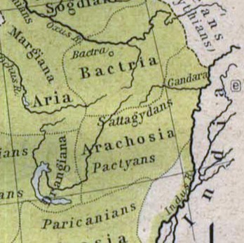
The territory was known around 500 BC as Drangiana, with Arachosia being to the east and Ariana to the north. It was part of the Median Empire followed by the Achaemenids. In 330 BC Alexander the Great took possession of the land and made it part of his empire. Upon Alexander's untimely death in 323 BC the region, along with the rest of his vast empire, was fought over by his generals all vying to be his successor. Eventually several of these were successful in carving out parts of Alexander's empire for themselves thereby becoming his official successors or Diadochi. One of these generals, Seleucus, made this region part of his domain giving it his name as the Seleucid Empire. They were replaced by other rulers and the area eventually fell to the Sassanids, then to the Arab Muslims. The Saffarids rose to power in 867 AD in Zaranj and made Farah part of their empire. By the 10th century the province became part of the Ghaznavid Empire, whose capital was located in Ghazni. They were replaced by the Ghurids and then after a century later the area saw the Mongol invasion.
The province was taken by Timur and eventually fell to the Safavid dynasty. It had been lost by the Safavids to the Uzbeks of Transoxiana, but was regained following a Safavid counter-offensive around 1600 CE, along with Herat and Sabzavar. In 1709, the Afghans gained independence from the Safavids and Farah became part of the Hotaki Empire. By 1747, it became part of Ahmad Shah Durrani's last Afghan empire. During the 19th century, the British army passed through the province to support Afghan forces in Herat Province against the invading Persians.
Following the Marxist revolution in 1978, Farah was one of the cities in which civilian massacres were carried out by the now-dominant Khalqi communists against their political, ethnic, and religious opponents. At the start of the 1980s, the majority of Farah was allied with the Harakat-i-Inqilab-i-Islami movement, but after 1981 the province split along linguistic lines, with Pashto-speaking opponents of the communist government remaining with Harakat, Group-e-Malema (Teacher Group) and Tajiks moving to the Jamiat-e Islami.
Following the 1992 collapse of the communist-backed Democratic Republic of Afghanistan, Farah Province, unlike many other provinces was relatively peaceful. Most of the Farah Mujahideen belonged to Harakat Islami of Malavi Khalas, Group-e-Malema (Teacher Group), Hizb-e-Islami and Jamiat Islami.
A 1995 Oxfam report lists Farah as "severely mined", and indicated that Farah was particularly problematic due to the wide variety of mine devices employed there, as well as usage of mines to deny access to irrigation systems. By late 1995, the stalemate broke as the Taliban counterattacked after Ismail Khan's failed drive to Kandahar, and all of Farah fell as the Taliban swept to take Herat on 5 September 1995.
Recent history up to 2009


Due to its isolation from the Taliban's area of focus, Farah exerted some small level of local control during Taliban rule. By the end of the Taliban period, there were eight United Nations Development Program (UNDP) schools, for both boys and girls, recognized and supported by the Taliban in Kandahar and Farah. UNDP noted that the local authorities in Farah were "particularly cooperative" on the subject.
Following the Coalition entry and union with the Northern Alliance after September 11, 2001, the Taliban withdrew from Farah due to the heavy Coalition aerial campaign, though ground troops were not sent to the province until some time later.
Farah witnessed heavy clashes after the US backed overthrow of the Taliban in 2001, and is being considered insecure, relative to many parts of the country. Although there was sporadic heavy combat in the Bala Baluk, Bakwa, Khak-e-Safid, Pusht-e-Road and Gulestan districts. Due to its proximity to the restive Helmand and Uruzgan provinces, Farah experienced problems with roaming insurgent gangs moving through the province and occupying parts of the province for brief periods of time. Incidents of this type have increased as Taliban fighters face heavy pressure from the International Security Assistance Force (ISAF) offensives in the south.
The roads in Farah province have seen massive improvement since May 2005 and are still being improved to date April 2006. The education system greatly improved and a large number of illegal weapons were collected and destroyed in the province as testimony to the Provincial Reconstruction Team. The United States built a base at Farah Airport, which is being expanded and also houses the Afghan National Security Forces (ANFS).
In May 2009, an American airstrike in the village of Granai in Bala Buluk District occurred that killed a large number of civilians. According to The New York Times, the villagers said that 147 were killed, an independent Afghan human rights group put the number of killed at 117. The Americans claimed the airstrike was targeting Taliban militants, but villagers said that the Taliban had left by the time the airstrike occurred. On May 19, the U.S. Ambassador to Afghanistan Karl Eikenberry visited Farah town to talk with the survivors. He promised that "the United States will work tirelessly with your government, army and police to find ways to reduce the price paid by civilians, and avoid tragedies like what occurred in Bala Baluk."
Administrative divisions

| District | Capital | title=Afghanistan: Verwaltungsgliederung (Provinzen und Bezirke) - Einwohnerzahlen, Grafiken und Karte | url=https://www.citypopulation.de/de/afghanistan/admin/ | website=citypopulation.de}} | Area in km2 | Pop. density |
|---|---|---|---|---|---|---|
| per km2 | Ethnic composition | |||||
| Anar Dara | 31,487 | 1,703 | 18 | 70% Tajiks, 30% Pashtuns. | ||
| Bakwa | 40,124 | 2,324 | 17 | 100% Pashtuns. | ||
| Bala Buluk | 80,778 | 5,525 | 15 | 95% Pashtuns, 5% Tajiks. | ||
| Farah | Farah | 128,047 | 3,588 | 36 | 85% Pashtuns, 10% Tajiks, 5% others. | |
| Gulistan | 49,025 | 6,576 | 7 | 80% Pashtuns, 20% Tajiks. | ||
| Khaki Safed | 34,277 | 1,938 | 18 | 99% Pashtuns, 1% Tajiks. | ||
| Lash Wa Juwayn | 31,621 | 5,323 | 6 | 50% Pashtuns, 50% Tajiks. | ||
| Pur Chaman | 60,450 | 6,188 | 10 | 95% Tajiks, 5% Pashtuns. | ||
| Pusht Rod | 45,969 | 327 | 141 | 99% Pashtuns, 1% Tajiks. | ||
| Qala-I-Kah/ | ||||||
| Pusht-e-Koh | 34,809 | 4,485 | 8 | 70% Pashtuns, 30% Tajiks. | ||
| Shib Koh | 26,439 | 2,928 | 9 | 70% Pashtuns, 15% Tajiks, 15% others. | ||
| Farah | 563,026 | 49,339 | 11 | 73.8% Pashtuns, 24.4% Tajiks, 1.8% others. |
Economy
Agriculture and mining
Farah's economy is overwhelmingly agricultural. The province has minerals such as gypsum, lime and construction stones, uranium ore, and copper. More than 1300 workers are employed by 15 manufacturing firms in the province. 74% of rural households reported either agriculture or livestock to be their main source of income and 24% reported that trade and service (including non-farm labor) to their main source of income.
Transportation
The Farah Airport is located next to the city of Farah and as of May 2014 had regularly scheduled flights to Herat.
The major road is Route 515 which connects Farah to the Ring Road between Herat and Kandahar. Both roads were improved in 2009 in coordination with several ISAF countries.
Demographics
Population
As of 2021, the total population of Farah province is about 573,146.
Ethnicity, languages and religion
Farah is predominately tribal and a rural society. Majority of the province is populated by Pashtuns, followed by Tajiks and Balochs. The Durrani Pashtuns, Nomads (Ghilji Pashtuns) and many other villagers are Pashtun tribes of the Noorzai, Barakzai, and Alizai. According to most recent estimates 80% of the Farah province are Pashtuns, 10% are Tajiks and 10% are Balochs.
| Ethnicity | Pashtun | Tajik/ | ||
|---|---|---|---|---|
| Farsiwan | Baloch | Other | Sources | Period |
| 2004–2021 | |
|---|---|
| (Islamic Republic) | |
| 75 – 80% | |
| 2021 DRC | |
| 2020 EU | |
| 2018 UN | |
| 2015 CP | |
| 2015 NPS | |
| 2012 CSSF | |
| 2011 USA | |
| 2009 ISW{{Cite web | title=Regional Command West |
| Legend: |
|---|
Education
The overall literacy rate (6+ years of age) fell from 28% in 2005 to 18% in 2011. The overall net enrollment rate (6–13 years of age) increased from 50% in 2005 to 68% in 2011.
Health
The percentage of households with clean drinking water increased from 3% in 2005 to 14% in 2011. 6% of births were attended to by a skilled birth attendant in 2011.
Culture

The tomb of Muhammad Jaunpuri is believed to be in Farah.
Notes
References
References
- (7 November 2021). "د نږدې شلو ولایاتو لپاره نوي والیان او امنیې قوماندانان وټاکل شول".
- . (April 2021). ["Estimated Population of Afghanistan 2021-22"](https://www.nsia.gov.af:8080/wp-content/uploads/2021/06/Estimated-Population-of-Afghanistan1-1400.pdf). *National Statistic and Information Authority (NSIA)*.
- "Farah – Program for Culture and Conflict Studies – Naval Postgraduate School".
- 0-521-20094-6, {{ISBN. 978-0-521-20094-3
- 0-521-39700-6, {{ISBN. 978-0-521-39700-1
- 0-85598-337-X, 9780855983376
- 1-85649-522-1, {{ISBN. 978-1-85649-522-6
- 1-876756-27-6, {{ISBN. 978-1-876756-27-7
- 1-4391-0946-X, 9781439109465
- 90-411-2191-9, {{ISBN. 978-90-411-2191-2
- Carlotta Grall. (May 14, 2009). "Afghan Villagers Describe Chaos of U.S. Strikes". The New York Times.
- Carlotta Grall. (May 19, 2009). "A Vow to Cut Afghan Civilian Deaths". The New York Times.
- "Afghanistan: Verwaltungsgliederung (Provinzen und Bezirke) - Einwohnerzahlen, Grafiken und Karte".
- (7 Jan 2005). "Anar Dara District Profile".
- (8 Nov 2004). "Bakwa District Profile".
- (28 Dec 2004). "Bala Bulok District Profile".
- (12 Sep 2004). "Farah City District Profile".
- (15 Oct 2004). "Gulistan District Profile".
- (11 Oct 2004). "Khak-e-Safid District Profile".
- (26 Jan 2005). "Lash o Jawain District Profile".
- (28 Oct 2004). "Purchaman District Profile".
- (22 Sep 2004). "Push-e-Rod District Profile".
- (2 Jan 2005). "Pusht-e-Koh District Profile".
- (3 Jan 2005). "Shib Koh District Profile".
- Bada, Ferdinand. (2019-04-15). "Natural Resources of Afghanistan".
- "National Area-Based Development Programme, Farah Provincial Profile".
- WFP, http://www.foodsecurityatlas.org/afg/country/provincial-Profile/Farah {{Webarchive. link. (2014-03-14)
- (February 3, 2009). "Province: Farah". [[Naval Postgraduate School]] (NPS).
- "فراه پایتخت".
- "Farah Provincial Overview". Naval Postgraduate School (NPS).
- "Provincial Development Plan, Farah Provincial Profile". Afghanistan Ministry of Rural Rehabilitation and Development and the United Nations Development Programme (UNDP).
- "Farah Naval Postgraduate School".
- (2021). "Afghanistan: Protection Monitoring Report Farah Province I December 2020 – February 2021".
- (2020). "Country Guidance: Afghanistan. Common analysis and guidance note". [[European Union Agency for Asylum]].
- Ramizpoor. (2018). "Afghan People’s Dialogue on Peace: Local Road Maps for Peace – Kabul and Surrounding Provinces". [[United Nations Assistance Mission in Afghanistan]].
- "Afghanistan National Drug Use Survey".
- "Farah - Program for Culture and Conflict Studies - Naval Postgraduate School".
- (2023-10-23). "State of Families CSSF Report: Farah, Afghanistan (2023)".
- (January 2011). "U.S. Army Afghanistan Smart Book, Third Edition".
- "Dai Kundi Province". Civil-Military Fusion Centre Archive.
This article was imported from Wikipedia and is available under the Creative Commons Attribution-ShareAlike 4.0 License. Content has been adapted to SurfDoc format. Original contributors can be found on the article history page.
Ask Mako anything about Farah Province — get instant answers, deeper analysis, and related topics.
Research with MakoFree with your Surf account
Create a free account to save articles, ask Mako questions, and organize your research.
Sign up freeThis content may have been generated or modified by AI. CloudSurf Software LLC is not responsible for the accuracy, completeness, or reliability of AI-generated content. Always verify important information from primary sources.
Report