From Surf Wiki (app.surf) — the open knowledge base
Elevation
Height of a geographic location above a fixed reference point

Height of a geographic location above a fixed reference point
The elevation of a geographic location is its height above or below a fixed reference point, most commonly a reference geoid, a mathematical model of the Earth's sea level as an equipotential gravitational surface (see Geodetic datum § Vertical datum). The term elevation is mainly used when referring to points on the Earth's surface, while altitude or geopotential height is used for points above the surface, such as an aircraft in flight or a spacecraft in orbit, and depth is used for points below the surface.

Elevation is not to be confused with the distance from the center of the Earth. Due to the equatorial bulge, the summits of Mount Everest and Chimborazo have, respectively, the largest elevation and the largest geocentric distance.
Aviation
In aviation, the term elevation or aerodrome elevation is defined by the ICAO as the highest point of the landing area. It is often measured in feet and can be found in approach charts of the aerodrome. It is not to be confused with terms such as the altitude or height.
Maps and GIS


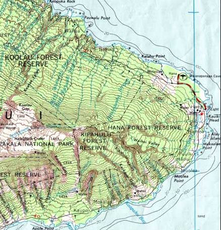
A topographical map is the main type of map used to depict elevation, often through contour lines. In a Geographic Information System (GIS), digital elevation models (DEM) are commonly used to represent the surface (topography) of a place, through a raster (grid) dataset of elevations. Digital terrain models are another way to represent terrain in GIS.
USGS (United States Geologic Survey) is developing a 3D Elevation Program (3DEP) to keep up with growing needs for high quality topographic data. 3DEP is a collection of enhanced elevation data in the form of high quality LiDAR data over the conterminous United States, Hawaii, and the U.S. territories. There are three bare earth DEM layers in 3DEP which are nationally seamless at the resolution of 1/3, 1, and 2 arcseconds.
References
References
- (1951). "AERODROMES". International Civic Aviation Organisation.
- Survey, U.S. Geological. "The National Map: Elevation".
This article was imported from Wikipedia and is available under the Creative Commons Attribution-ShareAlike 4.0 License. Content has been adapted to SurfDoc format. Original contributors can be found on the article history page.
Ask Mako anything about Elevation — get instant answers, deeper analysis, and related topics.
Research with MakoFree with your Surf account
Create a free account to save articles, ask Mako questions, and organize your research.
Sign up freeThis content may have been generated or modified by AI. CloudSurf Software LLC is not responsible for the accuracy, completeness, or reliability of AI-generated content. Always verify important information from primary sources.
Report