From Surf Wiki (app.surf) — the open knowledge base
El Hierro
Southwesternmost of the Canary Islands

Southwesternmost of the Canary Islands
| Field | Value |
|---|---|
| name | El Hierro |
| image_name | Santa Cruz de Tenerife SPOT 1320.jpg |
| image_size | 225 |
| map_image | Spain Canary Islands location map El Hierro.svg |
| map_caption | Location of El Hierro in the Canary Islands |
| nickname | Isla del Meridiano |
| location | Atlantic Ocean |
| coordinates | |
| archipelago | Canary Islands |
| area_km2 | 268.51 |
| area_footnotes | |
| highest_mount | Pico de Malpaso |
| elevation_m | 1501 |
| country | Spain |
| country_admin_divisions_title | Autonomous Community |
| country_admin_divisions | Canary Islands |
| country_admin_divisions_title_1 | Province |
| country_admin_divisions_1 | Santa Cruz de Tenerife |
| country_capital | Valverde |
| population | 11,659 |
| population_as_of | start of 2023 |
| density_km2 | 43.4 |
| languages | Spanish, specifically Canarian Spanish |
| timezone1 | WET |
| utc_offset1 | ±00:00 |
| timezone1_DST | WEST |
| utc_offset1_DST | +01:00 |
El Hierro (; ), nicknamed Isla del Meridiano (; ), is the southernmost and westernmost of the Canary Islands (an autonomous community of Spain), in the Atlantic Ocean off the coast of Africa, with a population of 11,659 (2023). Its capital is Valverde. At 268.51 km2, it is the second-smallest of the eight inhabited islands of the Canaries, with La Graciosa being the smallest.
Name
.jpg)
The name El Hierro, although spelled like the Spanish word for 'iron', is not related to that word. The H in the name of the metal is derived from the F of Latin ferrum (compare higo for 'fig'), a phonetic mutation that was complete by the end of the Middle Ages.
The confusion with the name of the metal had effects on the international naming of the island. As early as the 16th century, maps and texts called the island after the word for 'iron' in other languages: Portuguese Ferro, French l'île de Fer, and Latin Insula Ferri.
Nevertheless, the origin of the name ero or erro or yerro is not definitely known. It is thought to be derived from one of several words in the Guanche language of the pre-Hispanic inhabitants, known as Bimbaches. Juan de Abreu Galindo (in a manuscript translated and published by George Glas in 1764) gives the native name of the island as Esero (or Eseró), meaning 'strong'. Richard Henry Major, however, in notes on his translation of Le Canarien, observes that the Guanche word hero or herro, meaning 'cistern', could easily have lapsed into hierro by a process of folk etymology. It is believed that the Bimbaches had to construct cisterns to save fresh rainwater. The Gran diccionario guanche{{citation | title=Gran diccionario guanche : el diccionario de la lengua de los aborígenes canarios gives the meaning of the Guanche word hero in Spanish as "fuente" ('spring [water source]').
History

The ancient natives of the island, called Bimbaches, were subjected to Spanish rule by Jean de Béthencourt (d.1425) – more by the process of negotiation than by military action. Béthencourt had as his ally and negotiator Augeron, brother of the island's native monarch. Augeron had been captured years before by the Europeans and now served as mediator between the Europeans and the Guanches. In return for control over the island, Béthencourt promised to respect the liberty of the natives, but his son eventually broke his promise, selling many of the bimbaches into slavery. Many Frenchmen and Galicians subsequently settled on the island. There was a revolt of the natives against the harsh treatment of the governor Lázaro Vizcaíno, but it was suppressed.
Landslides and tsunami
There is evidence of at least three major landslides that have affected El Hierro in the last few hundred thousand years. The most recent of these was the 'El Golfo' landslide that occurred about 15,000 years ago, involving collapse of the northern flank of the island. The landslide formed the El Golfo valley and created a debris avalanche with a volume of 150–180 km3. Turbidite deposits related to this landslide have been recognized in drill cores from the Agadir Basin to the north of the Canary Islands. Detailed analysis of these deposits suggests that the slope failure did not occur as a single event but a series of smaller failures over a period of hours or days. Local tsunami are likely to have been triggered by these landslides but no evidence has been found to confirm this. [[File:Coast El Golfo.JPG|thumb|Coast El Golfo, El Hierro]]
2011 seismic activity
Main article: 2011–12 El Hierro eruption
The Instituto Vulcanológico de Canarias (Volcanological Institute of the Canary Islands) and National Geographic Institute's seismic monitoring station located in Valverde detected increased seismic activity beginning on 17 July 2011. by 27 July a further 320 earthquakes had been recorded. On 25 August there were reports that some horizontal deformation had been detected, but that there was no unusual vertical deformation. At that time, the total number of tremors had exceeded 4,000. Between 4;15 and 4:20 a.m. on 10 October 2011 the earthquake swarm changed behaviour and produced a harmonic tremor. Harmonic tremors are produced by magma movements and can indicate that an eruption has begun. Later the same day a small submarine eruption began, 7 km south of La Restinga. On 11 October the volcanic threat level at La Restinga was raised from "yellow" to "red" after minor rockfalls on the slopes above the town. Temporary evacuation of the 600 inhabitants was ordered and, despite a reduction in activity, they were still unable to return 20 days later. As of 7 November 2011 a confirmed surtseyan type of eruption phase has started at the fissure. On 4 December 2011 the eruption was ongoing with vigorous phreatic bubbles emerging. After the 2011 eruption, fossils of single-celled marine organisms were found in restingolites, a type of tephra, that were released into the water.
Climate
The precise climate of El Hierro depends on the area. The climate ranges are from subtropical Mediterranean (Csa / Csb) in the center of the island, to semi-arid (BSh) and to a desert climate (BWh) in coastal sections (according to the Köppen climate classification). It also has tropical climate (As) influences on some areas, as the coldest month average temperature does not fall below 18 C, but as precipitation is very low, the arid/semi-arid climate overlaps with the tropical climate, and therefore, its official classification according to AEMET is semi-arid or arid, depending on the exact area of the island. The temperatures are greatly influenced by the ocean. This is the climate chart from El Hierro Airport, which is the only airport in the island:
WMO ID: 60001; Climate ID: C929I; coordinates ; elevation: 32 m; 1991–2020 provisional normals, extremes 1973–present{{cite web |access-date = 14 December 2024 |archive-url = https://archive.today/20241128111913/https://opendata.aemet.es/opendata/sh/99e6e479 |archive-date = 2024-11-28}} |Jan record high C = 28.5 |Feb record high C = 29.4 |Mar record high C = 32.6 |Apr record high C = 33.2 |May record high C = 31.4 |Jun record high C = 32.0 |Jul record high C = 32.4 |Aug record high C = 33.8 |Sep record high C = 33.6 |Oct record high C = 35.4 |Nov record high C = 32.6 |Dec record high C = 28.3 |year record high C = 35.4 |Jan avg record high C = 23.8 |Feb avg record high C = 24.2 |Mar avg record high C = 25.4 |Apr avg record high C = 25.0 |May avg record high C = 26.1 |Jun avg record high C = 26.7 |Jul avg record high C = 27.6 |Aug avg record high C = 28.4 |Sep avg record high C = 28.8 |Oct avg record high C = 29.3 |Nov avg record high C = 27.3 |Dec avg record high C = 24.9 |year avg record high C = 30.8 |Jan avg record low C = 14.3 |Feb avg record low C = 14.3 |Mar avg record low C = 14.7 |Apr avg record low C = 15.2 |May avg record low C = 16.8 |Jun avg record low C = 18.5 |Jul avg record low C = 19.8 |Aug avg record low C = 20.8 |Sep avg record low C = 20.5 |Oct avg record low C = 19.1 |Nov avg record low C = 17.1 |Dec avg record low C = 15.6 |year avg record low C = 13.0 |Jan record low C = 8.0 |Feb record low C = 9.0 |Mar record low C = 9.2 |Apr record low C = 10.0 |May record low C = 10.0 |Jun record low C = 10.0 |Jul record low C = 14.0 |Aug record low C = 14.2 |Sep record low C = 15.2 |Oct record low C = 11.0 |Nov record low C = 12.0 |Dec record low C = 9.6 |year record low C = 8.0 |access-date = January 14, 2013}}{{cite web |access-date = 14 December 2024 |archive-url = https://archive.today/20241214151151/https://opendata.aemet.es/opendata/sh/0979bced |archive-date = 2024-12-14}}{{cite web |access-date = 14 December 2024 |archive-url = https://archive.today/20241214151046/https://opendata.aemet.es/opendata/sh/789b16c7 |archive-date = 2024-12-14}}{{cite web |access-date = 2024-11-13}} |access-date = 10 December 2024 |access-date = January 14, 2013 |archive-url = https://archive.today/20241214151451/https://www.aemet.es/es/serviciosclimaticos/datosclimatologicos/valoresclimatologicos?l=C929I&k=coo |archive-date = 2024-12-14}}}}
Note
Geography, flora and fauna

El Hierro's size and geography supports entirely endemic species including the critically endangered El Hierro giant lizard (Gallotia simonyi), for which there is a captive breeding programme, allowing its reintroduction.
The non-barren parts of the interior rely on relief precipitation, not much more than the average of 19 rainfall days per year, high relative humidity and geothermal springs. These non-arid parts have thermophilous (geothermal heat-liking) juniper clumps and a pine forest with other evergreens. In 2000, El Hierro was designated by UNESCO as a Biosphere Reserve, with 60% of its territory protected to preserve its natural and cultural diversity. Among cetaceans in these waters, it is notable that several species of lesser known beaked whales inhabit around the island.
Like the rest of the Canary Islands chain, El Hierro is volcanic and sharply mountainous. One eruption has to date been recorded on the island, but is not confirmed: from the Volcan de Lomo Negro vent in 1793, lasting a month. A submarine eruption occurred, however, offshore La Restinga village in 2011/2012. Except as landscaped at its harbour towns the shore is rocky and in places precipitous.
El Hierro is a 268.71 km2 island, formed late, about 1.2 million years ago after three successive eruptions, the island emerged from the ocean as a triangle of basaltic dykes topped with a volcanic cone more than 2,000 metres high. Continued activity resulted in the island expanding to have the largest number of volcanoes in the Canaries (over 500 cones, another 300 covered by more recent deposits), together with approximately 70 caves and volcanic galleries, including the Cueva de Don Justo whose collection of channels exceeds 6 km. Landslides, plant erosion and seasonal wind erosion have reduced the size and height of the island. The current highest point is in the middle of the island, in Malpaso, at 1501 m high.
Tourism and transportation

Like all of the Canary Islands, El Hierro is a tourist destination. It is served by a small airport—El Hierro Airport at Valverde—and a ferry terminal at Puerto de la Estaca, both of which connect to Tenerife. Though El Hierro has a Parador, hotel accommodations are generally in small family enterprises; as a UNESCO World Biosphere Reserve, El Hierro has limited construction to less than half of its total surface and buildings to two floors, maintaining its traditional look and social structure more than the other six major Canary Islands.
Political organization
The island is part of the province of Santa Cruz de Tenerife, and includes three municipalities:
| Name | Area | |||||
|---|---|---|---|---|---|---|
| (km2) | Census Population | Estimated | ||||
| Population | ||||||
| (2023) | 2001 | 2011 | 2021 | |||
| Frontera | 84.20 | 4,455 | 3,984 | 4,278 | 4,483 | |
| El Pinar | 80.66 | 0 | 1,750 | 1,936 | 2,027 | |
| Valverde | 103.65 | 4,227 | 4,992 | 5,076 | 5,149 | |
| Totals | 268.51 | 8,682 | 10,736 | 11,290 | 11,659 |
Valverde is situated in the northeast and Frontera in the west, both contain several villages.
The seat of the island government (cabildo insular) is in the town of Valverde, which houses approximately half of the island's population.
Migration
El Hierro and the Canaries have become bases for migration out of Africa. In early October 2023 boats carrying well over one thousand migrants had arrived within a few days many of them on "Spanish Lampedusa". "It is believed that the increase in arrivals in the Canary Islands is linked to the political and social crisis in Senegal."
The "Meridian Island"
Main article: Ferro Meridian
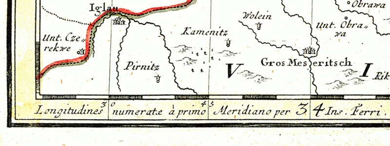
El Hierro was used in various parts of Europe for more than 500 years as the prime meridian, especially outside of the future British Empire. By the 2nd century CE, Ptolemy already considered a definition of the zero meridian based on the westernmost piece of land in the (known) world, giving a few maps with only positive, eastern longitudes.
In 1634, in France, as ruled by Louis XIII and his minister Richelieu, it was decided that Ferro's meridian should be used as a key reference of maps, in consideration of the island's historic meridian and status as the westernmost-known land of peoples of the 'Known World'. Flores Island is the westernmost Azore discovered by the Portuguese navigators in the early 15th century—after the First Voyage of Columbus in 1492 scholars and cartographers sometimes grouped them among the new world. The Paris elite considered El Hierro to be exactly 20° west of the Paris meridian (th of its relevant parallel of the globe).
Old international maps (outside of Anglo-North American realms) often have a common grid with Paris degrees at the top and Ferro degrees (offset by 20 from Paris) at the bottom. Louis Feuillée also worked on this problem in 1724.
Festivals
The most important festival of El Hierro is the Bajada de la Virgen de los Reyes, held every four years, on the first Saturday of July (the last occasion was in 2025, and the next will be in 2029). During the festival, the Virgin of the Kings (Virgen de los Reyes, patron saint of the island of El Hierro) is taken from her sanctuary in La Dehesa (in the municipality of La Frontera) and carried to the capital of the island, Valverde, making a tour of 44 kilometres and running through all the towns of El Hierro.
The annual festival of the Virgin is celebrated every September 24.
Natural symbols
Main article: List of animal and plant symbols of the Canary Islands
The official natural symbols associated with El Hierro are Gallotia simonyi machadoi (El Hierro giant lizard) and Juniperus phoenicea (Sabina).
File:Lagarto Gigante de El Hierro, Canarias, España.JPG|Gallotia simonyi machadoi File:El Hierro Sabinar.JPG|Juniperus phoenicea
Energy

According to the Ministry for Industry, Tourism and Commerce, El Hierro hopes to become the first island in the world to be self-sufficient for electrical energy. This will be achieved through a €54 million project combining a greater than 11-megawatt wind farm and two hydroelectric projects.
This hydro and wind-power project, created by the local Gorona del Viento El Hierro consortium with financial aid from the European Union, and officially inaugurated in 2015, consists of five E-70 wind turbines capable of producing 11.5 megawatts of wind power to supply electricity for approximately 11,000 residents, an additional number of tourists, and three water desalination facilities. The hybrid wind/pumped hydro storage system stores surplus wind power by pumping water up 700 metres (approximately 2,300 feet) to the crater of an extinct volcano. When winds are calm or when demand exceeds supply, water is released from the crater to generate 11.3 MW of electricity, filling a smaller artificial basin created at the bottom of the extinct volcano. Water in the lower basin is then pumped back up again to the upper reservoir when there is excess wind power.
The closed-loop hybrid wind/hydro system is expected to save approximately US$4M per year (calculated with January 2011 oil prices) previously spent on about 40,000 barrels of crude oil imported annually, attempting to make the island completely self-sufficient for electrical energy.
2016 was the first whole year for the power plant and it reached 40.7% of the total demand, reducing consumption of diesel by 6,000 tonnes. In 2017, the share climbed to 46.5%. The installation also powers a desalination plant that provides fresh water.
In early 2018, El Hierro covered its entire electricity demand between 25 January and 12 February with its renewable resource base, avoiding the use of polluting energy sources for more than 560 hours in 2018—and a total of almost 2,000 hours since it started operating.
Bimbache openART Festival
The Bimbache openART Festival and Global Initiative for Arts and Sustainability, founded in 2005 by German-born guitarist Torsten de Winkel and other community activists, is a non-profit effort at creating an interdisciplinary platform which seeks to bridge traditional divides, both on a musical and human level, in a globalizing world. The festival is a contribution of the international artist community to El Hierro's "Sustainable Island" program and collaborates with scientists and sustainability-oriented organizations from around the world.
El Hierro in literature
The island of Hierro is mentioned (1) in Umberto Eco's novel The Island of the Day Before (L'isola del giorno prima, 1994), about a 17th-century Italian nobleman trapped on an island on the International Date Line; (2) in Christopher Isherwood's short story "The Turn Round the World", collected in his Exhumations (1966); and (3) in the first chapter of Steven Callahan's (1986) maritime chronicle "Adrift", in which El Hierro is his final port of departure for an ill-fated Atlantic crossing.
Notes
References
- "Islas e islotes con superficie superior a 1 Km2". [[Instituto Geográfico Nacional (Spain).
- Instituto Nacional de Estadistica, Madrid, 2023.
- "Population referred to the January 1, 2018".
- Bory de Saint-Vincent, J.B.G.M.. (1803). "Essais sur les Isles Fortunées et l'antique Atlantide, ou Précis de l'histoire générale de l'archipel des Canaries". Baudouin.
- (1764). "The history of the discovery and conquest of the Canary islands". R. and J. Dodsley.
- (1872). "The Canarian, or, book of the conquest and conversion of the Canarians in the year 1402". Hakluyt Society.
- "History {{!}} portal".
- "El Hierro - Spain - tourist sights on the map".
- (2002). "Slope failures on the flanks of the western Canary Islands". Elsevier.
- (2006). "Submarine landslides: processes, triggers and hazard prediction". Royal Society.
- (26 July 2011). "Canary Islands Government Monitors El Hierro Earthquake Swarm". Sign of the Times.
- (27 July 2011). "More Than 720 Earthquakes Recorded On El Hierro In One Week". Reality-Choice.org.
- Martin, Daniel. (25 August 2011). "El enjambre sísmico de El Hierro suma más de 4.000 terremotos". [[Suite101]].
- (2012-06-30). "La erupción submarina de La Restinga en la isla de El Hierro, Canarias: Octubre 2011-Marzo 2012". [[Estudios Geológicos]].
- (10 October 2011). "Seismogram for El Hierro". [[Instituto Geográfico Nacional (Spain).
- (11 October 2011). "La erupción volcánica submarina de El Hierro libera magma y gases en el océano". [[El País]].
- (2015-11-01). "The 2011–2012 submarine eruption off El Hierro, Canary Islands: New lessons in oceanic island growth and volcanic crisis management". Earth-Science Reviews.
- (31 October 2011). "How not to handle a volcanic eruption". [[El País]].
- Hugh-Jones, Rob. (4 December 2011). "Canary Island volcano: A new island in the making?". [[BBC News]].
- "Fossils survive volcanic eruption to tell us about the origin of the Canary Islands".
- "Evolucion de los climas de Koppen en España: 1951-2020".
- "Biosphere Reserve Information, Spain, Isla de El Hierro". [[UNESCO]].
- (May 2007). "Los Zifios en las islas Canarias". Centro de Educacion Ambiental Municipal.
- (2021-01-01). "North-East Atlantic Islands: The Macaronesian Archipelagos". Academic Press.
- (26 May 2016). "The Geology of the Canary Islands - 1st Edition". Elsevier Science.
- (2002). "Canary Islands". Terra.
- "El Hierro, La isla, Geología". Cabildo de El Hierro.
- "Islas Canarias: Ferries – Fähren – Ferry". El Portal de la Isla de El Hierro.
- Estimate of 1 January 2023: from Instituto Nacional de Estadística, Madrid.
- Census of 1 November 2001: from Instituto Nacional de Estadística, Madrid.
- Census of 1 November 2011: from Instituto Nacional de Estadística, Madrid.
- Census of 1 January 2021: from Instituto Nacional de Estadística, Madrid.
- total included in figure for Frontera. The new Municipality of El Pinar was created in 2007 by splitting off the former southern portion of the Municipality of Frontera.
- red, ORF at/Agenturen. (2023-10-06). "Hohe Zahl an Geflüchteten überfordert kleine Kanaren-Insel".
- (2023-10-06). "Ten boats carrying nearly 900 migrants arrive in the Canary Islands this Friday".
- (2023-10-06). "Canary Islands appeal for help as 1,200 migrants arrive in 48 hours".
- (2023-10-06). "Canary Island El Hierro overwhelmed by the arrival of hundreds of migrants".
- (2008). "Canarias, otra mirada. Viajeros, exploradores y naturalistas. Cuaderno de Actividades". Fundación Canaria Orotava.
- [http://www.gobcan.es/boc/1991/061/001.html Ley 7/1991, de 30 de abril, de símbolos de la naturaleza para las Islas Canarias]
- Frayer, Lauren. (28 September 2014). "Tiny Spanish Island Nears Its Goal: 100 Percent Renewable Energy". [[NPR]].
- [http://www.insula-elhierro.com/english.htm El Hierro 100% RES web site with articles, animation and references to partner organizations] {{webarchive. link. (November 23, 2008)
- [http://old.insula.org/islandsonline/El%20Hierro-1.pdf Article titled "Sun, wind and water The new El Hierro island's allies" in pdf format] {{webarchive. link. (June 13, 2007)
- Cala, Andrés. (19 January 2011). "Tiny Spanish Island Has a Huge Stake in the Future". [[The New York Times]].
- Murray, James. (6 January 2014). "Wind power was Spain's top source of electricity in 2013". [[The Guardian]].
- (4 March 2018). "Gorona del Viento has the wind on its sails".
- [https://static1.squarespace.com/static/57766ea7d482e9b4340d1531/t/57f4eaaed482e9ea7f3ff323/1475668686930/El+Hierro+Wind-Pumped+hydro+power+station%2C+Alberto+Castaneda+Quintero.pdf EL HIERRO WIND-PUMPED HYDRO POWER STATION] page 15
- (6 January 2019). "El Hierro fourth quarter 2018 performance update".
This article was imported from Wikipedia and is available under the Creative Commons Attribution-ShareAlike 4.0 License. Content has been adapted to SurfDoc format. Original contributors can be found on the article history page.
Ask Mako anything about El Hierro — get instant answers, deeper analysis, and related topics.
Research with MakoFree with your Surf account
Create a free account to save articles, ask Mako questions, and organize your research.
Sign up freeThis content may have been generated or modified by AI. CloudSurf Software LLC is not responsible for the accuracy, completeness, or reliability of AI-generated content. Always verify important information from primary sources.
Report