From Surf Wiki (app.surf) — the open knowledge base
Egmanton
Village and civil parish in Nottinghamshire, England
Village and civil parish in Nottinghamshire, England
| Field | Value |
|---|---|
| country | England |
| coordinates | |
| official_name | Egmanton |
| population | 271 |
| population_ref | (2021) |
| static_image_caption | A view of Egmanton looking east from the church entrance gate |
| shire_district | Newark and Sherwood |
| shire_county | Nottinghamshire |
| region | East Midlands |
| constituency_westminster | Newark |
| post_town | NEWARK |
| postcode_district | NG22 |
| postcode_area | NG |
| dial_code | 01777 |
| os_grid_reference | SK 733687 |
| type | Village and civil parish |
| static_image_name | egmanton.jpg |
| mapframe | yes |
| mapframe-zoom | 12 |
| mapframe-point | none |
| static_image_2_caption | Parish map |
| area_total_sq_mi | 3.46 |
| london_distance_mi | 120 |
| london_direction | SSE |
| website |
| mapframe-zoom = 12 | mapframe-point = none
Egmanton is a small village and civil parish in Nottinghamshire, England, and is located one mile south of Tuxford and one mile north of Laxton. According to the 2001 census it has 254 inhabitants in 101 households in the civil parish, the population taken at the 2011 census went up to 286, and this fell to 271 for the 2021 census. The name derives from the Old English words for Ecgmund's farm/settlement.
The nearest larger towns are Retford and Newark-on-Trent. It is located approximately 35 metres above sea level.
It is part of the ward of Caunton in the administrative district of Newark and Sherwood District Council and the county of Nottinghamshire. It lies within the Parliamentary constituency of Newark.
Egmanton was mentioned in the Domesday Survey of 1086.
The amenities include an Anglican church, a village hall (formerly the old school) and a pub, 'The Old Plough'. The main economic activity in the village is farming.
Historical sites
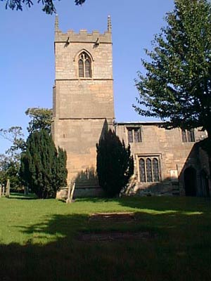
Egmanton Church – 'Our Lady of Egmanton Church'
Main article: Church of Our Lady of Egmanton
Egmanton church is best known for the Shrine of Our Lady of Egmanton contained within the church itself. A pilgrimage takes place throughout the year to commemorate the shrine.
Egmanton Castle

Egmanton Castle consists of the remains of a Motte and Bailey style castle. It is commonly known as Gaddick Hill.
Medieval fish ponds
To the west of the village off Kirton road are some earthworks which are the remains of medieval fish ponds, now dry, which were important to people in the Middle Ages.
Windmill
A tower windmill was located at the southern end of Mill Lane ().
Oil fields
Oil has been produced from the East Midlands oil fields since 1939 with some production wells located around Egmanton. Although many have now closed, some of these wells remain in production to this day. On a national scale the level of production was never significant.
References
References
- "UK Government Web Archive".
- "Civil Parish population 2011". Office for National Statistics.
- "Egmanton parish".
- "The Shrine of Our Lady of Egmanton {{!}} The Shrine of Our Lady of Egmanton".
- Tidswell, Emma. (2023-09-05). "Why Were Medieval Fishponds so Important?".
- Carmen. (2022-05-05). "Egmanton Conventional Oil Field, UK".
- "Star Energy".
This article was imported from Wikipedia and is available under the Creative Commons Attribution-ShareAlike 4.0 License. Content has been adapted to SurfDoc format. Original contributors can be found on the article history page.
Ask Mako anything about Egmanton — get instant answers, deeper analysis, and related topics.
Research with MakoFree with your Surf account
Create a free account to save articles, ask Mako questions, and organize your research.
Sign up freeThis content may have been generated or modified by AI. CloudSurf Software LLC is not responsible for the accuracy, completeness, or reliability of AI-generated content. Always verify important information from primary sources.
Report