From Surf Wiki (app.surf) — the open knowledge base
Egger Highlands, San Diego
Neighborhood in Southern San Diego
Neighborhood in Southern San Diego
| Field | Value | |
|---|---|---|
| name | Egger Highlands, San Diego | |
| official_name | Egger Highlands | |
| settlement_type | Community of San Diego | |
| image_skyline | Egger Highlands, San Diego, CA, USA - panoramio (2).jpg | |
| area_code | 619 | |
| postal_code | 92154 | |
| named_for | Robert Egger Sr. | |
| subdivision_type | Country | |
| subdivision_type1 | State | |
| subdivision_type2 | County | |
| subdivision_name | ||
| image_caption | The Salt Works Plant located on the North side of Egger Highlands. | |
| motto | ||
| pushpin_map | United States San Diego Southern | |
| pushpin_mapsize | ||
| pushpin_map_caption | Location within Southern San Diego | |
| coordinates | ||
| subdivision_name1 | California | |
| subdivision_name2 | Flag of San Diego County, California.png San Diego | |
| subdivision_type3 | City | |
| subdivision_name3 | Flag of San Diego, California.svg San Diego | |
| <!-- Smaller parts (e.g. boroughs of a city) and seat of government --> | established_date | |
| parts_style | ||
| parts | ||
| total_type | ||
| postal_code_type | ZIP code | |
| population_as_of | 2020 | |
| population_total | 12,102 | |
| elevation_m | 2 | |
| elevation_ft | 7 |
Default is list if up to 5 items, coll if more than 5--
Egger Highlands is a residential neighborhood in the southern section of downtown San Diego, California. It neighbors Palm City and Nestor to the east, San Diego Bay to the north, Imperial Beach to the southwest and Chula Vista to the northeast. Major thoroughfares include Coronado Avenue, Saturn Boulevard, and Palm Avenue.
History
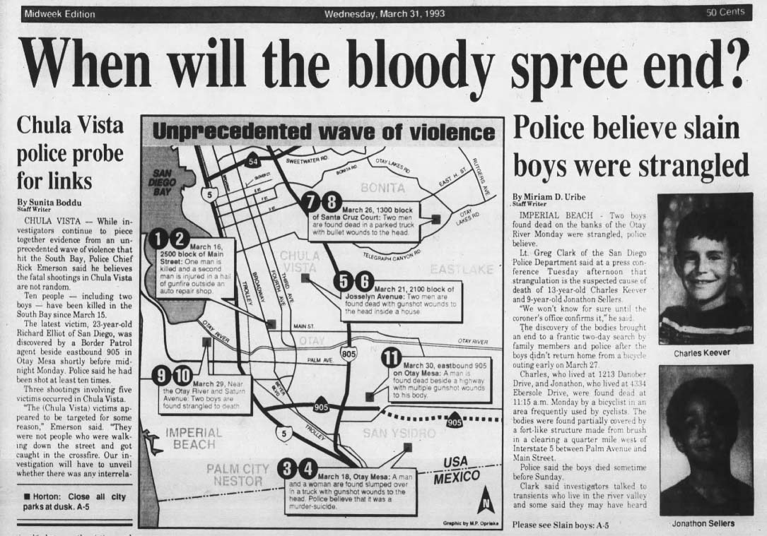
Egger Highlands is named for the Egger family, which donated land in 1946 to house St. Charles Catholic Church, the area's first Roman Catholic church. Egger Highlands, along with other portions of South San Diego, was annexed by the city of San Diego from San Diego County in 1957. In 1993, The murders of Charlie Keever and Jonathan Sellers were believed to have occurred on the Otay River Valley Bike Trail behind the Southland Shopping Center.
Facilities and landmarks
Egger Highlands is home to the Robert Egger, Sr. Community Park, located at Coronado Avenue and Saturn Boulevard.
Education
Private schools in Egger Highlands include the St. Charles School. The area is served by Sweetwater Union High School District and it currently houses just one Middle School which includes Mar Vista Academy.
References
References
- "Parish History". Saint Charles Catholic Church.
- [http://www.sandiego.gov/citycouncil/cd8/communities/eggerhighlands/index.shtml Egger Highlands], City of San Diego Communities
- Uribe, Miriam. "When will the bloody spree end?".
- "Home page". Saint Charles Catholic School.
This article was imported from Wikipedia and is available under the Creative Commons Attribution-ShareAlike 4.0 License. Content has been adapted to SurfDoc format. Original contributors can be found on the article history page.
Ask Mako anything about Egger Highlands, San Diego — get instant answers, deeper analysis, and related topics.
Research with MakoFree with your Surf account
Create a free account to save articles, ask Mako questions, and organize your research.
Sign up freeThis content may have been generated or modified by AI. CloudSurf Software LLC is not responsible for the accuracy, completeness, or reliability of AI-generated content. Always verify important information from primary sources.
Report