From Surf Wiki (app.surf) — the open knowledge base
Durham County, North Carolina
County in North Carolina, United States
County in North Carolina, United States
| Field | Value |
|---|---|
| county | Durham County |
| state | North Carolina |
| seal | Durham County Seal.png |
| founded | 1881 |
| named for | Bartlett Snipes Durham |
| seat wl | Durham |
| largest city wl | Durham |
| city type | community |
| area_total_sq_mi | 297.86 |
| area_land_sq_mi | 286.53 |
| area_water_sq_mi | 11.33 |
| area percentage | 3.80 |
| population_as_of | 2020 |
| population_total | 324833 |
| pop_est_as_of | 2024 |
| population_est | 343628 |
| density_sq_mi | auto |
| mapframe | yes |
| mapframe-marker | none |
| coordinates | |
| web | https://dconc.gov |
| ex image | Durham County Justice.JPG |
| ex image cap | Durham County Courthouse |
| logo | DCO Shield Color.png |
| district | 4th |
| time zone | Eastern |
| flag | Durham County Flag.gif |
| motto | "Live. Grow. Thrive." |
| mapframe-marker = none
Durham County is a county located in the U.S. state of North Carolina. As of the 2020 census, the population was 324,833, making it the sixth-most populous county in North Carolina. Its county seat is Durham, which is the only incorporated municipality predominantly in the county, though very small portions of cities and towns mostly in neighboring counties also extend into Durham County. The central and southern parts of Durham County are highly urban, consisting of the city as well as several unincorporated suburbs. Southeastern Durham County is dominated by the Research Triangle Park, most of which is in Durham County. The northern third of Durham County is rural in nature. Durham County is the core of the Durham–Chapel Hill, NC Metropolitan Statistical Area, which is also included in the Raleigh–Durham–Cary, NC Combined Statistical Area, which had an estimated population of 2,368,947 in 2023.
History
The county was formed on April 17, 1881, from parts of Orange County and Wake County, taking the name of its own county seat. In 1911, parts of Cedar Fork Township of Wake County were transferred to Durham County and became Carr Township.
Geography
According to the U.S. Census Bureau, the county has a total area of 297.86 sqmi, of which 286.53 sqmi is land and 11.33 sqmi (3.80%) is water.
State and local protected areas/sites
- Bennett Place State Historic Site
- Butner-Falls of Neuse Game Land (part)
- Duke Homestead and Tobacco Factory
- East Durham Historic District
- Eno River State Park (part)
- Falls Lake State Recreation Area (part)
- Historic Stagville
- Hollow Rock Nature Park (part)
- Horton Grove Nature Preserve
- Jordan Game Land (part)
- Little River Regional Park and Natural Area (part)
- Mason Farm Biological Reserve (part)
- Museum of Life and Science
- Rolling View State Recreation Area (part)
Major water bodies
- B. Everett Jordan Lake
- Crabtree Creek
- Ellerbe Creek
- Eno River
- Falls Lake
- Flat River
- Lake Michie
- Little River
- New Hope Creek
- Stirrup Iron Creek
Adjacent counties
- Person County – north
- Granville County – northeast
- Wake County – east-southeast
- Chatham County – south
- Orange County – west
Major highways
- (Durham)
- (to Orange County)
- (truck route)
Major infrastructure
- Durham Station
Demographics
|align-fn=center 1790–1960 1900–1990 1990–2000 2010–2020
2020 census
| Race / Ethnicity (NH = Non-Hispanic) | title=P004: Hispanic or Latino, and Not Hispanic or Latino by Race – 2000: DEC Summary File 1 – Durham County, North Carolina | url=https://data.census.gov/table/DECENNIALSF12000.P004?q=P004:+HISPANIC+OR+LATINO,+AND+NOT+HISPANIC+OR+LATINO+BY+RACE+[73]&g=050XX00US37063 | publisher=United States Census Bureau | access-date= }} | title=P2 Hispanic or Latino, and Not Hispanic or Latino by Race – 2010: DEC Redistricting Data (PL 94-171) - Durham County, North Carolina | url=https://data.census.gov/table/DECENNIALPL2010.P2?q=p2&g=050XX00US37063 | website=United States Census Bureau}} | % 2000 | % 2010 |
|---|---|---|---|---|---|---|---|---|---|
| White alone (NH) | 107,371 | 112,697 | 133,768 | 48.08% | |||||
| Black or African American alone (NH) | 87,516 | 100,260 | 109,225 | 39.19% | |||||
| Native American or Alaska Native alone (NH) | 531 | 722 | 704 | 0.24% | |||||
| Asian alone (NH) | 7,311 | 12,180 | 16,707 | 3.27% | |||||
| Pacific Islander alone (NH) | 65 | 135 | 83 | 0.03% | |||||
| Other race alone (NH) | 436 | 700 | 1,809 | 0.20% | |||||
| Mixed race or Multiracial (NH) | 3,045 | 4,816 | 12,433 | 1.36% | |||||
| Hispanic or Latino (any race) | 17,039 | 36,077 | 50,104 | 7.63% | |||||
| Total | 223,314 | 267,587 | 324,833 | 100.00% |
As of the 2020 census, there were 324,833 people, 134,653 households, and 75,291 families residing in the county. The median age was 35.0 years; 20.1% of residents were under the age of 18 and 13.8% of residents were 65 years of age or older. For every 100 females there were 91.0 males, and for every 100 females age 18 and over there were 88.3 males age 18 and over.
There were 134,653 households in the county, of which 26.7% had children under the age of 18 living in them. Of all households, 38.3% were married-couple households, 19.9% were households with a male householder and no spouse or partner present, and 34.4% were households with a female householder and no spouse or partner present. About 33.1% of all households were made up of individuals and 9.2% had someone living alone who was 65 years of age or older.
There were 144,559 housing units, of which 6.9% were vacant. Among occupied housing units, 52.2% were owner-occupied and 47.8% were renter-occupied. The homeowner vacancy rate was 1.5% and the rental vacancy rate was 6.9%.
The racial makeup of the county was 42.9% White, 34.1% Black or African American, 0.7% American Indian and Alaska Native, 5.2% Asian,
94.9% of residents lived in urban areas, while 5.1% lived in rural areas.
2000 census
At the 2000 census, there were 223,314 people, 89,015 households, and 54,032 families residing in the county. The population density was 769 /mi2. There were 95,452 housing units at an average density of 329 /mi2. The racial makeup of the county was 50.91% White, 39.46% Black or African American, 0.30% Native American, 3.29% Asian, 0.04% Pacific Islander, 4.21% from other races, and 1.80% from two or more races. 7.63% of the population were Hispanic or Latino of any race.
There were 89,015 households, out of which 29.10% had children under the age of 18 living with them, 42.00% were married couples living together, 14.80% had a female householder with no husband present, and 39.30% were non-families. 30.00% of all households were made up of individuals, and 7.00% had someone living alone who was 65 years of age or older. The average household size was 2.40 and the average family size was 2.99.
In the county, the age distribution was as follows: 22.90% under the age of 18, 12.80% from 18 to 24, 34.80% from 25 to 44, 19.80% from 45 to 64, and 9.70% who were 65 years of age or older. The median age was 32 years. For every 100 females there were 93.00 males. For every 100 females age 18 and over, there were 89.70 males.
The median income for a household in the county was $43,337, and the median income for a family was $53,223. Males had a median income of $35,939 versus $30,683 for females. The per capita income for the county was $23,156. About 9.80% of families and 13.40% of the population were below the poverty line, including 17.20% of those under age 18 and 12.30% of those age 65 or over.
Fertility rates
The fertility rates in Durham have remained relatively stable, with the fertility rates for females aged 15–44 between 2022 and 2024, being 53%, with women aged 30–34 making up approximately 91.1% of all births in Durham county. There have been about 20,604 births between 2022-2024.
Law and government
- 181 Deputies
- 211 Detention Officers
Durham County is a member of the regional Triangle J Council of Governments. Durham County is governed by a five-member board of county commissioners, currently consisting of Chair Brenda A. Howerton, Vice Chair Wendy Jacobs, Nimasheena Burns, Heidi Carter, and Nida Allam. All are elected concurrently, and each elected member serves a four-year term. The current sheriff, Clarence Birkhead, was elected in 2018 and is the county's first African American Sheriff to hold office.
Politics
Durham County is consistently one of the most Democratic counties in North Carolina, favoring Democrats in national, state, and local elections. It has only voted for the Republican candidate twice since 1884, in the Republican landslides of 1928 and 1972. George H. W. Bush is the last Republican to manage even 40 percent of the county's vote. Since the 1990s, Durham County has been one of the most Democratic urban counties in the South.
Communities
The city of Durham is the only incorporated municipality to predominantly exist within Durham County, and the only one whose urban core lies within the county, though small portions of municipalities from neighboring counties extend into Durham County, and the city of Durham also itself extends slightly into neighboring counties. All other towns and places within Durham County are unincorporated communities.
Cities
- Durham (county seat and largest community; small portions extend into Wake and Orange counties)
- Raleigh (mostly in Wake County)
Towns
- Chapel Hill (mostly in Orange County)
- Morrisville (mostly in Wake County)
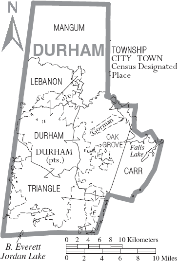
Townships
- Carr
- Durham
- Lebanon
- Mangum
- Oak Grove
- Triangle
Census-designated places
- Gorman
- Rougemont (small portions extend into neighboring Person County)
Unincorporated communities
- Bahama
- Bethesda
- Genlee
- Lowe's Grove
- Nelson
- Oak Grove
- Braggtown
Notable person
- Margaret O'Neal (1884–?), sharecropper
References
References
- "Find a County". National Association of Counties.
- (March 14, 2024). "Metropolitan and Micropolitan Statistical Areas Population Totals: 2020-2023". [[United States Census Bureau]], Population Division.
- (August 23, 2022). "2020 County Gazetteer Files – North Carolina". United States Census Bureau.
- "NCWRC Game Lands".
- "Hollow Rock Nature Park".
- (December 11, 2015). "Miles of Trails with More in the Making - Triangle Land Conservancy".
- "Little River Regional Park & Natural Area".
- "Mason Farm Biological Reserve - North Carolina Botanical Garden".
- "Rollingview at Falls Lake Durham, NC".
- "County Population Totals and Components of Change: 2020-2024". United States Census Bureau.
- "U.S. Decennial Census". United States Census Bureau.
- "Historical Census Browser". University of Virginia Library.
- (March 27, 1995). "Population of Counties by Decennial Census: 1900 to 1990". United States Census Bureau.
- (April 2, 2001). "Census 2000 PHC-T-4. Ranking Tables for Counties: 1990 and 2000". United States Census Bureau.
- "QuickFacts: Durham County, North Carolina". United States Census Bureau.
- "P004: Hispanic or Latino, and Not Hispanic or Latino by Race – 2000: DEC Summary File 1 – Durham County, North Carolina". [[United States Census Bureau]].
- "P2 Hispanic or Latino, and Not Hispanic or Latino by Race – 2010: DEC Redistricting Data (PL 94-171) - Durham County, North Carolina".
- "P2 Hispanic or Latino, and Not Hispanic or Latino by Race – 2020: DEC Redistricting Data (PL 94-171) - Durham County, North Carolina".
- (2021). "2020 Decennial Census Demographic Profile (DP1)".
- (2021). "2020 Decennial Census Redistricting Data (Public Law 94-171)".
- (2023). "2020 Decennial Census Demographic and Housing Characteristics (DHC)".
- "U.S. Census website". [[United States Census Bureau]].
- "General Fertility Rates".
- (2017). "Annual Report FY 2016-2017". Durham Sheriff.
- "Contact the Board of Commissioners {{!}} Durham County".
- Simmons, Taj. (December 3, 2018). "New Durham County Sheriff Takes Oath of Office".
- (November 4, 2022). "Anatomy of a swing state: What these 6 counties tell us about the upcoming NC election". The Charlotte Observer.
- Leip, David. "Dave Leip's Atlas of U.S. Presidential Elections".
- [http://www.raleighnc.gov/content/PlanLongRange/Documents/Maps/Raleigh_Durham_Annexation_Agreement_Lines.pdf Raleigh Durham Annexation Agreement Lines] {{webarchive. link. (October 19, 2011)
- "Federal Writers Project Papers".
This article was imported from Wikipedia and is available under the Creative Commons Attribution-ShareAlike 4.0 License. Content has been adapted to SurfDoc format. Original contributors can be found on the article history page.
Ask Mako anything about Durham County, North Carolina — get instant answers, deeper analysis, and related topics.
Research with MakoFree with your Surf account
Create a free account to save articles, ask Mako questions, and organize your research.
Sign up freeThis content may have been generated or modified by AI. CloudSurf Software LLC is not responsible for the accuracy, completeness, or reliability of AI-generated content. Always verify important information from primary sources.
Report