From Surf Wiki (app.surf) — the open knowledge base
Dukan Dam
Dam in Sulaymaniyah Governorate, Kurdistan Region
Dam in Sulaymaniyah Governorate, Kurdistan Region
| Field | Value |
|---|---|
| name | Dukan (Dokan) Dam |
| image | Dukan Dam.jpg |
| location_map | Iraq |
| coordinates | |
| dam_crosses | Little Zab |
| status | O |
| spillway_count | 2 |
| spillway_type | Service: Tunnel |
| Emergency: Bell-mouth | |
| spillway_capacity | Service: 2450 m3/s |
| Emergency: 1860 m3/s | |
| res_name | Lake Dukan |
| res_capacity_total | 6970000000 m3 |
| res_capacity_active | 6100000000 m3 |
| res_capacity_inactive | 790000000 m3 |
| res_catchment | 11690 km2 |
| res_surface | 270 km2 |
| res_elevation | 511 m |
| plant_hydraulic_head | 95 m (rated) |
| location | As Sulaymaniyah Governorate, Kurdistan Region |
| operator | Ministry of Water Resources |
| dam_length | 360 m |
| dam_height | 116.5 m |
| dam_width_crest | 6.2 m |
| dam_width_base | 34.3 m |
| dam_volume | 370000 m3 |
| dam_elevation_crest | 516 m |
| dam_type | Cylindrical arch |
| construction_began | 1954 |
| opening | 1959 |
| plant_turbines | 5 x 80 MW Francis-type |
| plant_capacity | 400 MW |
| plant_commission | 1979 |
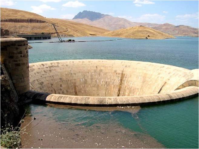
Emergency: Bell-mouth Emergency: 1860 m3/s The Dukan Dam (Sorani Kurdish: بەنداوی دووکان Arabic: سد دوكان) is a multi-purpose concrete arch dam in As Sulaymaniyah Governorate, Kurdistan Region of Iraq. It impounds the Little Zab, thereby creating Lake Dukan. The Dukan Dam was built between 1954 and 1959 whereas its power station became fully operational in 1979. The dam is 360 m long and 116.5 m high and its hydroelectric power station has a maximum capacity of 400 MW.
Project history
The Dukan Dam was built between 1954 and 1959 as a multi-purpose dam to provide water storage, irrigation and hydroelectricity. The design for the dam was carried out by the British engineering company Binnie & Partners (with Partner and third generation Binnie engineer Geoffrey Binnie the key engineer). Additional structural analysis was done for Binnie by his friends at Imperial College, Professor Pippard and Letitia Chitty, who "developed a stress analysis technique using relaxation methods and a rubber model to verify the design form."
Prior to the flooding of Lake Dukan, the area was subjected to archaeological research to investigate as many archaeological sites as possible. An archaeological survey in the Ranya Plain documented some 40 archaeological sites with evidence for occupation ranging from the sixth millennium BCE up to the present. Five of these sites were then excavated: Tell Bazmusian, ed-Dem, Kamarian, Qarashina and Tell Shemshara. The excavations at Tell Bazmusian revealed a temple dating to the second millennium BCE. At Tell Shemshara, an early-sixth millennium BCE village was excavated, as well as an early-second millennium BCE palace with a small archive of clay tablets. The inhabitants of some 50 villages in the flooded area, around 1,000–1,200 families, were resettled to the west of the lake. The power station was designed in 1973 by the Russian company Hydroproject and became operational in 1979.
In 1990 the dam was used to house a group of 'human shield' hostages. They were held initially at the guest lodge nearby, thereafter in the offices adjacent to the cafeteria inside the dam and later inside prefabricated huts on the top of the dam. The intention was to deter coalition air strikes in the upcoming 1991 Gulf war. They were released in December 1990 and returned home.
Due to lack of maintenance and repairs, the power station has underperformed and is now, after 30 years of service, due for replacement. In 2007, the World Bank began a US$40 million project to repair the Dokan and Darbandikhan Dams. Repairs to the Dokan Dam are expected to cost over $8 million and be complete in late 2012.
Characteristics of the dam

The Dukan Dam is a multi-purpose concrete arch dam abutted by gravity monoliths. It is 360 m long and 116.5 m high. At its base it is 32.5 m wide, tapering off to 6.2 m at the top. The combined maximum discharge of the dam is 4300 m3 per second. This is divided over a spillway tunnel with three radial gates having a combined maximum discharge of 2440 m3 per second, and an emergency bell mouth spillway with a capacity of 1860 m3 per second. Two irrigation outlets with a combined discharge of 220 m3 per second have not been operated over the last ten years. The powerhouse of five Francis units at 80 MW each releases between 110 and per second. Lake Dukan, the reservoir created by the Dukan Dam, has a surface area of 270 km2. Its anticipated capacity is 6.8 km3 with a maximum of 8.3 km3.
References
References
- (31 July 2006). "Dokan and Derbendikhan Dam Inspections". World Bank.
- (6 June 2003). "Iraqi Dam Assessments". United States Army, Corps of Engineers.
- Kliot, Nurit. (1994). "Water Resources and Conflict in the Middle East". Routledge.
- (1984). "Dokan hydroelectric station in Iraq". Power Technology and Engineering.
- Muir Wood, Sir Alan. (1990). "Biographical Memoirs of Fellows of the Royal Society: Geoffrey Morse Binnie (13 November 1908 - 5 April 1989)". Royal Society.
- Carlyle, Bill. (2008). "The Binnie heritage in dam engineering". Dams and Reservoirs.
- (1970). "Mounds in the Rania Plain and excavations at Tell Bazmusian (1956)". Sumer.
- (2001). "The Shemshara archives 1. The letters". Kongelige Danske videnskabernes selskab.
- Mortensen, Peder. (1970). "Tell Shimshara. The Hassuna period". Kongelige Danske videnskabernes selskab.
- (1996). "Encyclopedia of the modern Middle East". Macmillan Reference.
- (5 October 2021). "How a 'human shield' hostage and his reluctant captor became friends". ABC News.
- (2006). "Dokan and Derbandikhan Emergency Hydro Power Project". www.krg.org.
- "Dokan and Derbandikhan Emergency Hydro Power Project". World Bank.
- Iraqi Ministries of Environment, Water Resources and Municipalities and Public Works. (2006). "New Eden Master Plan for integrated water resources management in the marshlands areas". New Eden Group.
This article was imported from Wikipedia and is available under the Creative Commons Attribution-ShareAlike 4.0 License. Content has been adapted to SurfDoc format. Original contributors can be found on the article history page.
Ask Mako anything about Dukan Dam — get instant answers, deeper analysis, and related topics.
Research with MakoFree with your Surf account
Create a free account to save articles, ask Mako questions, and organize your research.
Sign up freeThis content may have been generated or modified by AI. CloudSurf Software LLC is not responsible for the accuracy, completeness, or reliability of AI-generated content. Always verify important information from primary sources.
Report