From Surf Wiki (app.surf) — the open knowledge base
Duck, North Carolina
| Field | Value | |
|---|---|---|
| official_name | Duck, North Carolina | |
| settlement_type | Town | |
| named_for | Duck | |
| image_skyline | Enjoy the Boardwalk.JPG | |
| imagesize | 270px | |
| image_alt | Boardwalk over Currituck Sound with reflecting sunlight | |
| image_caption | The boardwalk at Duck Town Park in 2009 | |
| image_flag | Duck, NC Town Flag.gif | |
| image_seal | Duck, NC Town Seal.png | |
| image_map | Dare County North Carolina incorporated and unincorporated areas Duck highlighted.svg | |
| mapsize | 270px | |
| map_caption | Location in Dare County, North Carolina | |
| pushpin_map | North Carolina#USA | |
| pushpin_label | Duck | |
| pushpin_relief | yes | |
| subdivision_type | Country | |
| subdivision_name | United States | |
| subdivision_type1 | State | |
| subdivision_name1 | North Carolina | |
| subdivision_type2 | County | |
| subdivision_name2 | Dare | |
| leader_title | Mayor | |
| established_title | Founded | |
| established_date | 1984 | |
| established_title1 | Incorporated | |
| established_date1 | 2002 | |
| unit_pref | Imperial | |
| area_footnotes | ||
| area_total_km2 | 9.64 | |
| area_land_km2 | 6.26 | |
| area_water_km2 | 3.38 | |
| area_total_sq_mi | 3.72 | |
| area_land_sq_mi | 2.42 | |
| area_water_sq_mi | 1.30 | |
| <!-- Population --> | population_as_of | 2020 |
| population_total | 742 | |
| population_density_km2 | 118.54 | |
| population_density_sq_mi | 306.99 | |
| <!-- General information --> | timezone | Eastern (EST) |
| utc_offset | −05:00 | |
| timezone_DST | EDT | |
| utc_offset_DST | −04:00 | |
| elevation_m | 2 | |
| elevation_ft | 7 | |
| coordinates | ||
| postal_code_type | ZIP Code | |
| postal_code | 27949 | |
| area_code_type | Area code | |
| area_code | 252 | |
| blank_name | FIPS code | |
| blank_info | 37-18060 | |
| blank1_name | GNIS feature ID (populated place) | |
| blank1_info | ||
| blank2_name | GNIS feature ID (town) | |
| blank2_info | ||
| website |
Duck is a town in Dare County, North Carolina, United States. As of the 2020 census, the population was 746. Duck is the northernmost incorporated town in Dare County and the Outer Banks' newest town, incorporated on May 1, 2002. Duck offers visitors outdoor recreational activities, summer events and concerts, watersports, fine dining, shopping, art galleries, and a nationally known jazz festival, as well as the 11 acre Town Park and soundside boardwalk.
History
On March 28, 2001, state representative William T. Culpepper III introduced the Duck Incorporation Bill in the North Carolina House of Representatives. The bill was passed on August 29, 2001. On November 6, 2001, voters voted in favor of incorporation, and Duck was incorporated as the sixth town in Dare County on May 1, 2002.
The Caffeys Inlet Lifesaving Station was listed on the National Register of Historic Places in January 1978.
Geography
Duck is located along the northern Outer Banks, between the Atlantic Ocean to the east and Currituck Sound to the west. According to the United States Census Bureau, the town has a total area of 9.6 km2, of which 6.3 sqkm is land and 3.4 sqkm, or 35.02% is water. Originally part of Currituck County to the north, the stretch of the Outer Banks which includes Duck was transferred to Dare County in the early 20th century. The region was named for the many ducks and waterfowl in the area.
According to the A. W. Kuchler U.S. potential natural vegetation types, Duck, North Carolina would have a dominant vegetation type of Live oak/Sea Oats Uniola paniculata (90) with a dominant vegetation form of Coastal Prairie (20).
Climate
The town of Duck marks the northernmost extent of hardiness zone 8b along the east coast of the United States.
| Climate data for Duck, North Carolina | Month | Jan | Feb | Mar | Apr | May | Jun | Jul | Aug | Sep | Oct | Nov | Dec | Year | Average sea temperature °F (°C) | Source: NOAA |
|---|---|---|---|---|---|---|---|---|---|---|---|---|---|---|---|---|
| 45 | ||||||||||||||||
| (7) | 44 | |||||||||||||||
| (7) | 46 | |||||||||||||||
| (8) | 59 | |||||||||||||||
| (15) | 67 | |||||||||||||||
| (19) | 74 | |||||||||||||||
| (23) | 71 | |||||||||||||||
| (22) | 74 | |||||||||||||||
| (23) | 75 | |||||||||||||||
| (24) | 69 | |||||||||||||||
| (21) | 59 | |||||||||||||||
| (15) | 52 | |||||||||||||||
| (11) | 61 | |||||||||||||||
| (16) |
Demographics
2020 census
| Race | Number | Percentage | White (non-Hispanic) | Asian | Other/Mixed | Hispanic or Latino |
|---|---|---|---|---|---|---|
| 697 | 93.94% | |||||
| 7 | 0.94% | |||||
| 22 | 2.96% | |||||
| 16 | 2.16% |
As of the 2020 United States census, there were 742 people, 288 households, and 202 families residing in the town.
Tourist attractions
The town park is a recreational facility with trails through the maritime forest and willow swamp. It also has an amphitheater, playground, picnic shelter, and public kayak/canoeing launch. The town has built a boardwalk which can be accessed from the park and through the commercial village. The boardwalk extends 0.78 mi along Currituck Sound. Duck's beach was named one of the "Top 15 Family-Friendly Beaches in America".
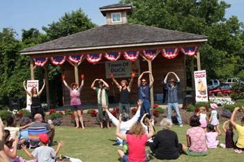
In October, Duck hosts its annual Jazz Festival. During the summer months, the town offers over 60 events and programs including Yoga on the Green, Movies on the Sound, a family magic show, live concerts and interactive theater. Programs are free and open to the public.
Government
In addition to traditional town council meetings, there are regularly scheduled meetings where the public can address issues before the council.
Duck is one of only a very few US municipalities that is an anti-bellwether, meaning it has voted for the losing candidate in each of the past 4 presidential elections. (Romney, Clinton, Trump, Harris).
Education
Residents are zoned to Dare County Schools. Zoned schools are Kitty Hawk Elementary School, First Flight Middle School, and First Flight High School. Prior to 2004, First Flight High zoned students were zoned to Manteo High School.
Notable residents
- Harold R. Story, US Army major general
References
References
- "ArcGIS REST Services Directory". United States Census Bureau.
- {{cite gnis
- {{cite gnis
- Outerbanks SEO. (2012). "Town of Duck North Carolina".
- {{NRISref. 2013a
- "U.S. Potential Natural Vegetation, Original Kuchler Types, v2.0 (Spatially Adjusted to Correct Geometric Distortions)".
- "North Carolina 2012 USDA Hardiness Zone Map". USDA.
- "Water Temperature Table of All Coastal Regions".
- "City and Town Population Totals: 2020-2021". US Census Bureau.
- "Census of Population and Housing". Census.gov.
- "Explore Census Data".
- "Town Park & Boardwalk". Town of Duck.
- Ferguson, J. (n.d.). Town council. Retrieved from http://www.townofduck.com/
- "Attendance Zone Information". [[Dare County Schools]].
- Freeman, Darren. (August 18, 2004). "NO LINES, NO CROWDS, JUST MORE SPACE". [[The Virginian-Pilot]].
- (10 September 1987). "Death Notice, Harold R. Story". [[Newsday]].
This article was imported from Wikipedia and is available under the Creative Commons Attribution-ShareAlike 4.0 License. Content has been adapted to SurfDoc format. Original contributors can be found on the article history page.
Ask Mako anything about Duck, North Carolina — get instant answers, deeper analysis, and related topics.
Research with MakoFree with your Surf account
Create a free account to save articles, ask Mako questions, and organize your research.
Sign up freeThis content may have been generated or modified by AI. CloudSurf Software LLC is not responsible for the accuracy, completeness, or reliability of AI-generated content. Always verify important information from primary sources.
Report