From Surf Wiki (app.surf) — the open knowledge base
Drin (river)
River in southeastern Europe
River in southeastern Europe
| Field | Value |
|---|---|
| name | Drin |
| native_name | |
| name_other | Drim |
| image | Drini River flowing in Shkodër.jpg |
| image_caption | Drin delta flowing through Shkodër |
| subdivision_type1 | Countries |
| subdivision_name1 | |
| subdivision_type3 | Region |
| subdivision_name3 | Southern Europe |
| subdivision_type5 | Cities |
| subdivision_name5 | |
| length_km | 285 |
| length_ref | |
| discharge1_location | the river mouth |
| discharge1_avg | 352 m3/s |
| discharge1_max | 1800 m3/s |
| source1 | White Drin at Zhleb Mountains near Radavc |
| source1_location | Kosovo, Peja District |
| source2 | Black Drin at Lake Ohrid near Struga |
| source2_location | North Macedonia, Struga Municipality |
| source_confluence | Near Kukës |
| source_confluence_location | Kukës County, Albania |
| mouth | Large Drin: Buna |
| Small Drin: Gulf of Drin | |
| mouth_location | Large Drin: Shkodër County |
| Small Drin: Lezhë County, Albania | |
| mouth_elevation | 5 m |
| progression | Adriatic Sea |
| basin_size_km2 | 19,686 |
| basin_size_ref | |
| tributaries_left | Black Drin, Mirusha, Prizren, Toplluha |
| tributaries_right | White Drin, Sateska, Radika, Perro, Bushtrica, White Drin: Peja, Deçan, Erenik, Black Drin: Valbona, Shala, Kir, Mertur |
Small Drin: Gulf of Drin Small Drin: Lezhë County, Albania
The Drin (; , Drini, ) or Drim (Serbian and , ), is a river in Southeastern Europe with two major tributaries – the White Drin and the Black Drin and two distributaries – one discharging into the Adriatic Sea, in the Gulf of Drin and the other into the Buna River. Its catchment area extends across Albania, Kosovo, Serbia, Greece, Montenegro and North Macedonia and is home to more than 1.6 million people. The river and its tributaries form the Gulf of Drin, an ocean basin that encompasses the northern Albanian Adriatic Sea Coast.
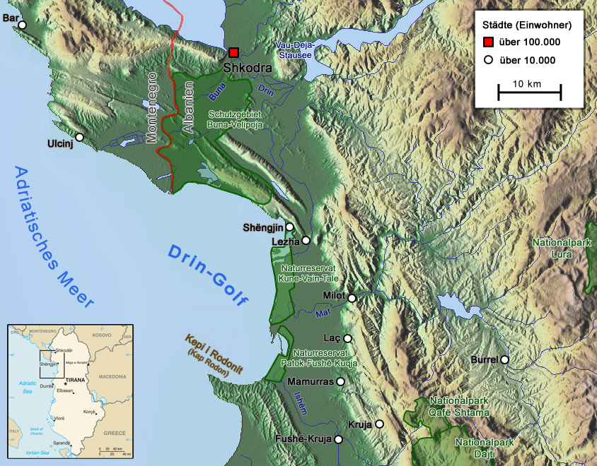
At 285 km long, the Drin is the longest river of Albania and its tributaries cross through both Kosovo and North Macedonia. Its northern tributary, the White Drin starts from the foothills of Žljeb, at White Drin Waterfall in west Kosovo, and flows generally south, whereas its southern tributary, the Black Drin originates from Ohrid lake in the town of Struga, North Macedonia and flows north. Both tributaries' confluence occurs near Kukës in northeast Albania and Drin then flows westwards through the Albanian Alps and Dukagjin Highlands, where three successive dams were erected between 1960s and late 1980s, forming 3 large artificial lakes. The Drin then passes Vau i Dejës and drains into the Adriatic Sea through its two distributaries in Buna river and west of Lezhë.
Located in the Balkan Peninsula at the crossroad of Europe and Asia, the river basin's varied climate and topography have shaped a vast array of flora and fauna. In addition, it has been recognized as one of the most important biodiversity hotspots in Europe. The Drin Delta is classified as an Important Bird Area of international importance by designation under the BirdLife International Convention.
Etymology
The name of the river is recorded in Ancient Greek as Drilon (Δρίλων) and in Latin as Drinus. The name is considered to be of Illyrian origin. The form Drin- has been evidenced by Pliny the Elder ( 1st century AD) and is most likely primary. The ancient name Drinus has undergone sound changes reaching the current Albanian form Drin through the evolution of Albanian sound changes. The Macedonian name of the river is Дрим, Drim. Homonym rivers are Drino between southern Albania and northwestern Greece, and Drina between Bosnia and Herzegovina and Serbia.
Geography
After the confluence of its two tributaries, near the town of Kukës in the northeast Albania, Drin flows west, passing through the Albanian Alps and Fierzë then upon reaching the Dukagjini highlands, flowing then to the south through Apripë e Gurit, Toplanë, Dushman, Koman, Vjerdhë Mazrrek, Rragam, and Pale Lalej. At Vau i Dejës, it enters the low Shkodër Field and splits into two distributaries. One empties into the Gulf of Drin into the Adriatic Sea southwest of Lezhë, forming the Mouth of Drin. The other empties into the Bojana River near the Rozafa Castle.
The Black Drin flows out from the Lake Ohrid near Struga through western North Macedonia and then eastern Albania. The White Drin originates from the Žljeb mountain, north of the town of Peja in the Dukagjin region of Kosovo, and flows from there through to Albania.
The basin encompasses the transboundary subbasins of Lake Shkodër (largest lake in Southern Europe), Lake Ohrid (one of the most ancient lakes in the World), Lake Prespa and Small Prespa Lake and also the tributaries, namely Black Drin, White Drin and Bojana River. All these subbasins and tributaries are home to numerous species of mammals, vascular plants, insects, amphibians, fish and birds.
Economy
Drin river contains the largest hydroelectric power station group in the Balkans regarding the installed capacity and reservoir capacity. The Drin is extremely important for the Albanian economy, especially for its electrical production. The three largest hydropower facilities produce 70.6% of Albania's electricity (approx. 1400MW of total installed capacity). North Macedonia has built two hydropower plants – Globocica (42 MW) and Spilje Hydro Power Plant (84 MW) on the Black Drin.
The artificial Lake Fierza created by the dam at Fierzë is the largest artificial lake in Albania with its surface of 73 km2. The second largest artificial lake is also built on this river. Vau i Dejës lake has an area of 25 km2. Construction of the Fierza power station caused some controversy in the 1980s. Without reaching any agreement, the Albanian government ordered the reservoir to be filled with water, which flooded some border areas of Kosovo, then part of Yugoslavia. The Yugoslav government protested, but no solution was agreed on. Thus, today, Lake Fierza is shared by Albania and Kosovo.
Watershed basin
| located within North Macedonia | located within Kosovo
Drin
Black Drin
- , Zalli i Bulqizës river
- (L): Banjë, Deshat, Gramë, Tepuz, Veleshicë, Prillushë and Tershan streams
- (R): Mur, Setë, Mollë and Lurë streams
- Lumë river
- Orgjost and Topojan streams
- Pecmarë, Vrulla e Shoshanit, Gashi and Tropojë streams
- Okol and Shtrazë streams
- Theth river
- Kaprej and Maja e Zezë streams
- Bigë, Gura e Lekajt, Kosan and Shehu i Abatit streams
- Stupje stream
- Lesniqe river
- (L): Curraj stream
- Kuç stream
- (R): Nikaj stream
History
The ancient name of the river was Drilon. The valley of the river was inhabited by several Illyrian peoples. It was probably dominated at some point and to some extent by the Enchele. The tribal territory of the Taulantii and of the Labeatae was most likely located near the river.
Annotations
Bibliography
References
References
- (2021). "Small Water Bodies of the Western Balkans". [[Springer Nature]].
- Kabo, Mevlan. (1990). "Gjeografia Fizike e Shqipërisë 1". Akademia e Shkencave e RPS të Shqipërisë.
- "ALBANIA".
- "HYDROLOGY OF THE TRANSBOUNDARY DRIN RIVER BASIN".
- "Drin".
- "Internationally Shared Surface Water Bodies in the Balkan Region".
- "Drin Basin".
- Elsie, Robert. (2010). "Historical Dictionary of Albania". [[Scarecrow Press]].
- Kabo, Mevlan. (1990). "Gjeografia Fizike e Shqipërisë 1". Akademia e Shkencave e RPS të Shqipërisë.
- "The natural wealth and legacy of the Drin River Basin: inspiring our collective actions".
- "Drin River Basin The blue heart of the Balkans".
- "Drini Delta".
- (31 January 2009). "Rivers of Europe". Academic Press.
- (2013). "A new freshwater snail genus (Hydrobiidae, Gastropoda) from Montenegro, with a discussion on gastropod diversity and endemism in Skadar Lake". ZooKeys.
- "Natural and Cultural Heritage of the Ohrid region".
- "Albania Upgrades Electrical Grid in the Balkans".
- (October 5, 2022). "Sustainable Nexus solutions for Drin river basin".
- Wilkes, J. J.. (1995). "The Illyrians". Blackwell Publishing.
- Tom Streissguth. (2011). "Albania in Pictures". Twenty-First Century Books.
This article was imported from Wikipedia and is available under the Creative Commons Attribution-ShareAlike 4.0 License. Content has been adapted to SurfDoc format. Original contributors can be found on the article history page.
Ask Mako anything about Drin (river) — get instant answers, deeper analysis, and related topics.
Research with MakoFree with your Surf account
Create a free account to save articles, ask Mako questions, and organize your research.
Sign up freeThis content may have been generated or modified by AI. CloudSurf Software LLC is not responsible for the accuracy, completeness, or reliability of AI-generated content. Always verify important information from primary sources.
Report