From Surf Wiki (app.surf) — the open knowledge base
Dras
| Field | Value |
|---|---|
| name | Dras |
| nickname | The Gateway to Ladakh |
| settlement_type | Town |
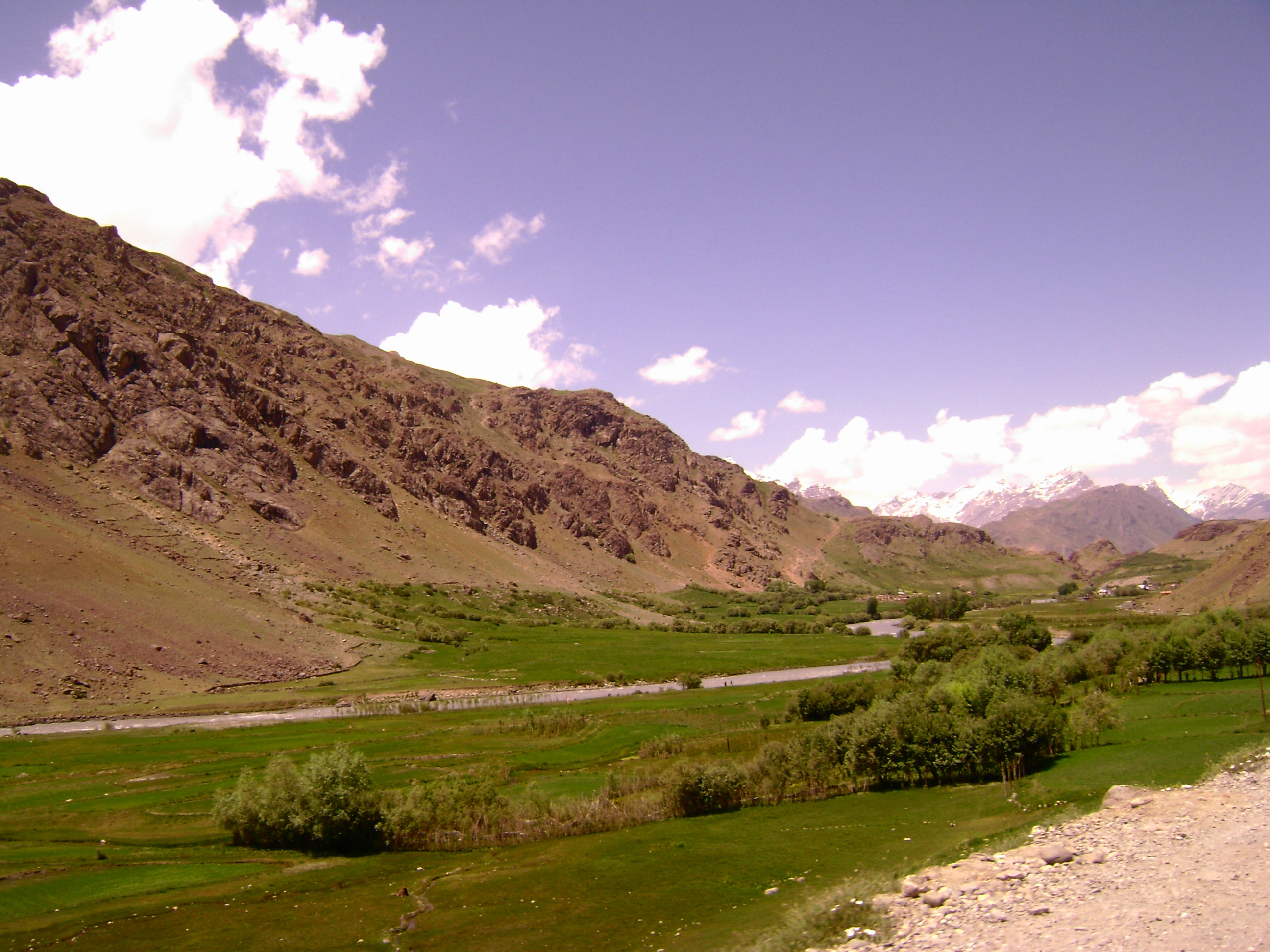
| image_skyline | Drass and Tololing Range.jpg |
| image_caption | View of Dras in Kargil district, Ladakh (India) |
| pushpin_map | India Ladakh#India |
| pushpin_relief | y |
| pushpin_label_position | right |
| pushpin_map_caption | Location in Ladakh, India |
| coordinates | |
| subdivision_type | Country |
| subdivision_name | India |
| subdivision_type1 | Union Territory |
| subdivision_name1 | Flag of Ladakh, India.svg Ladakh |
| subdivision_type2 | District |
| subdivision_name2 | Kargil |
| subdivision_type3 | Tehsil |
| subdivision_name3 | Dras |
| established_title | |
| unit_pref | Metric |
| elevation_footnotes | |
| elevation_m | 3300 |
| population_total | 21988 |
| population_density_km2 | auto |
| demographics_type1 | Languages |
| demographics1_title1 | Official |
| demographics1_title2 | Spoken |
| demographics1_info2 | Shina, Urdu, Purgi, Balti |
| timezone1 | IST |
| utc_offset1 | +5:30 |
| postal_code_type | PIN |
| postal_code | 194102 |
| registration_plate | LA-01 |
| website | |
| official_name | Drass |
| mapframe | yes |
| mapframe-wikidata | yes |
| mapframe-wikidata = yes
Dras (also spelt Drass, ISO transliteration: Drās), also known locally as Himababs, Hembabs, or Humas, is a town and hill station in Kargil district of the union territory of Ladakh in India. It is on the NH 1 between Zoji La pass and Kargil town. A tourist hub for its high-altitude trekking routes and tourist sites, it is often called "The Gateway to Ladakh". The government's official spelling of the town's name is "Drass".
Etymology
Traditionally, Dras is known as Hem-babs, which means "snow land"; the word "Hem" means snow. The average temperature of Dras in winter is −20 °C.
Geography
Dras is often called "The Gateway to Ladakh". It is at a height of 10800 ft. Dras lies in the centre of the valley of the same name. Dras is 140 km from Srinagar and 63 km from Sonmarg. Kargil town is 58 km from Dras on the national highway NH 1 from Srinagar to Leh.
History

In the princely state of Jammu and Kashmir (1846–1947), Dras was part of the Kargil tehsil of the Ladakh wazarat.
During the invasion by Pakistan in 1947-48, the reinforced Gilgit Scouts, having gone over to Pakistan, attacked the Kargil area on 10 May 1948. The Indian army, by then in charge of defending Kashmir, sent reinforcements. However, they could not reach Dras in time and Dras fell to the Gilgitis on 6 June 1948. Kargil and Skardu also fell in short order. In November 1948, the Indian Army launched Operation Bison, supported by tanks, and retook Dras and Kargil. Skardu, however, remained under the control of Pakistan. The 1949 ceasefire line runs 12 km north of Dras through Point 5353.
The ceasefire line was renamed the Line of Control in the 1972 Simla Agreement, in which India and Pakistan agreed to respect the line without prejudice to their stated positions.
However, in the early months of 1999, Pakistani soldiers masquerading as mujahideen, infiltrated the area and took control of the peaks overlooking Dras and the highway, in particular Tololing, 4 km from Dras, and Tiger Hill, 8 km from Dras. They directed artillery fire at Dras and the highway, leading to the Kargil War. The Indian army cleared the Tololing and Tiger Hill peaks by July 1999.
Climate
Dras is the coldest place in India, experiencing an altitude-influenced Continental Mediterranean climate (Köppen climate classification: Dsb). Winters are cold with average lows around −20 °C (−4 °F), and as low as −23 °C at the height of winter, which lasts from mid-October to mid-May. Summers start in June and go on up till early September, with average temperatures near 23 °C (74 °F) and little precipitation. Annual precipitation is almost entirely concentrated from December to May when Dras gets around 550 mm water equivalent of snowfall. There is a popular claim as well various signs/boards showing Dras being second coldest inhabited place in the world. However, there is no reliable weather data to substantiate the claim.{{climate chart |Dras |- 23|-8|96.5 |- 22|-6|99.6 |- 15|-1|137.1 |- 6|5|104.1 |1|14|60.9 |6|21|22.3 |9|24|15.2 |10|24|16.2 |5|20|17.7 |- 1|13|20.3 |- 10|4|32.5 |- 19|-3|53.3 |Jan record high C = 5 |Feb record high C = 6 |Mar record high C = 10 |Apr record high C = 18 |May record high C = 25 |Jun record high C = 30 |Jul record high C = 33 |Aug record high C = 31 |Sep record high C = 29 |Oct record high C = 25 |Nov record high C = 15 |Dec record high C = 9 |Jan record low C = -42 |Feb record low C = -43 |Mar record low C = -33 |Apr record low C = -25 |Jun record low C = -8 |Jul record low C = -5 |Aug record low C = -5 |Sep record low C = -5 |Oct record low C = -20 |Nov record low C = -29 |Dec record low C = -45 |year record low C = -48
Demographics
Ethnicity
The major ethnic groups are the Shina people, who speak the Indo-Aryan language Shina, and the Purigpa people, whose language, similar to Balti belong to the Tibetic group. Shina ethnic group forms majority of the population at around 65-70% while the Purgi/Balti ethnic group is a significant minority making up around 30-35% of the population. The local population is 64% male and 36% female. In total the population of Dras per the 2011 Census is 21988. Out of this, 14,731 are males while 7,257 are females. This block has 2,767 kids in the age bracket of 0–6 years. Among them 1,417 are boys and 1,350 are girls.
Religion
The population is 99% Muslim. The Shina people are mostly Sunni making up around 65-75% of the population while the Purigi/Balti people are mostly Shias forming 25-35% of the population. The Kashmiris are a very small minority and are Sunni Muslims. Islam first arrived to the region due to the influence of Kashmiri merchants. Drass is the only area (now a district) in Ladakh where Sunni Muslims comprise the majority of the population.
Culture
Many inhabitants of Dras cultivate primary crops like barley. The locals also raise livestock like cattle and ponies.
Common foods in the diet of the people include potatoes, barley, lamb, mutton and drinks like tea. Polo is a very popular pastime in Dras.
Tourism
Dras has been developed as a tourist destination since 1999, following the Kargil War, when visitors came to see the war zone. The 130-km road connecting the Gurez Valley to Mushkoh Valley in Kargil’s Drass Sector, connected by Kaobal Gali (4,166.9 metres, between Abdullum and Batokul), the highest pass in Gurez, is now open for tourists, offering a glimpse into the historic landscape of the Kargil War. These areas, once battlegrounds, hold significant importance in the Kargil conflict.{{cite web | access-date = 20 April 2025
In early 2025, high-speed public 4G/5G mobile and internet connectivity was made available by India.
References
Bibliography
References
- "Revenue Villages | District Kargil, Union Territory of Ladakh | India".
- Singh Negi, Sharad. (2002). "Cold Deserts of India". Indus Publishing.
- "Page on Dras from". ladakh-kashmir.com.
- "About District {{!}} District Kargil, Union Territory of Ladakh {{!}} India".
- Schuh, Dieter. (2014). "Drass".
- Swami, Praveen. (11 August 2000). "Pakistan still occupies key Dras point". The Hindu Business Line.
- "Climate of Jammu & Kashmir". India Meteorological Department.
- "Page 4. Rambirpur (Drass)". Censusindia.gov.in.
- Aabedi, Zain-ul-aabedin. (2009). "Emergence of Islam in Ladakh". Atlantic Publishers & Distributors.
- Keatinge, Hilary. (1993). "The Road to Leh".
- Bhan, Mona. (2013). "Counterinsurgency, Democracy, and the Politics of Identity in India: From Warfare to Welfare?". Routledge.
- [https://navbharattimes.indiatimes.com/india/troops-in-ladakh-get-4g-5g-connectivity-at-high-altitude-posts-even-up-to-siachen-glacier/articleshow/120434416.cms लद्दाख में सैनिकों को ऊंचाई वाली चौकियों पर मिली 4जी/5जी कनेक्टिविटी, सियाचिन ग्लेशियर तक सिग्नल], navbharattimes, 19 Apr 2025.
This article was imported from Wikipedia and is available under the Creative Commons Attribution-ShareAlike 4.0 License. Content has been adapted to SurfDoc format. Original contributors can be found on the article history page.
Ask Mako anything about Dras — get instant answers, deeper analysis, and related topics.
Research with MakoFree with your Surf account
Create a free account to save articles, ask Mako questions, and organize your research.
Sign up freeThis content may have been generated or modified by AI. CloudSurf Software LLC is not responsible for the accuracy, completeness, or reliability of AI-generated content. Always verify important information from primary sources.
Report