From Surf Wiki (app.surf) — the open knowledge base
Donegal, Pennsylvania
Borough in Pennsylvania, US
Borough in Pennsylvania, US
| Field | Value |
|---|---|
| official_name | Donegal, Pennsylvania |
| settlement_type | Borough |
| image_skyline | Main Street Donegal Pennsylvania.jpg |
| image_caption | Main Street |
| pushpin_map | Pennsylvania |
| pushpin_label_position | right |
| subdivision_type | Country |
| subdivision_name | United States |
| subdivision_type1 | State |
| subdivision_name1 | Pennsylvania |
| subdivision_type2 | County |
| subdivision_name2 | Westmoreland |
| government_type | Borough Council |
| leader_title | Mayor |
| established_title | Settled |
| established_date | 1796 |
| established_title1 | Incorporated |
| established_date1 | August 20, 1867 |
| unit_pref | Imperial |
| area_footnotes | |
| area_total_km2 | 0.59 |
| area_land_km2 | 0.59 |
| area_water_km2 | 0.00 |
| area_total_sq_mi | 0.23 |
| area_land_sq_mi | 0.23 |
| area_water_sq_mi | 0.00 |
| population_as_of | 2020 |
| population_footnotes | |
| population_total | 102 |
| population_density_km2 | 173.37 |
| population_density_sq_mi | 449.34 |
| timezone | Eastern (EST) |
| utc_offset | -5 |
| timezone_DST | EDT |
| utc_offset_DST | -4 |
| coordinates | |
| elevation_ft | 1834 |
| postal_code_type | Zip code |
| postal_code | 15628 |
| blank_name | FIPS code |
| blank_info | 42-19472 |
| image_map | File:Westmoreland County Pennsylvania Incorporated and Unincorporated areas Donegal Highlighted.svg |
| map_caption | Location of Donegal in Westmoreland County, Pennsylvania. |
:There are also three Donegal Townships in Pennsylvania.
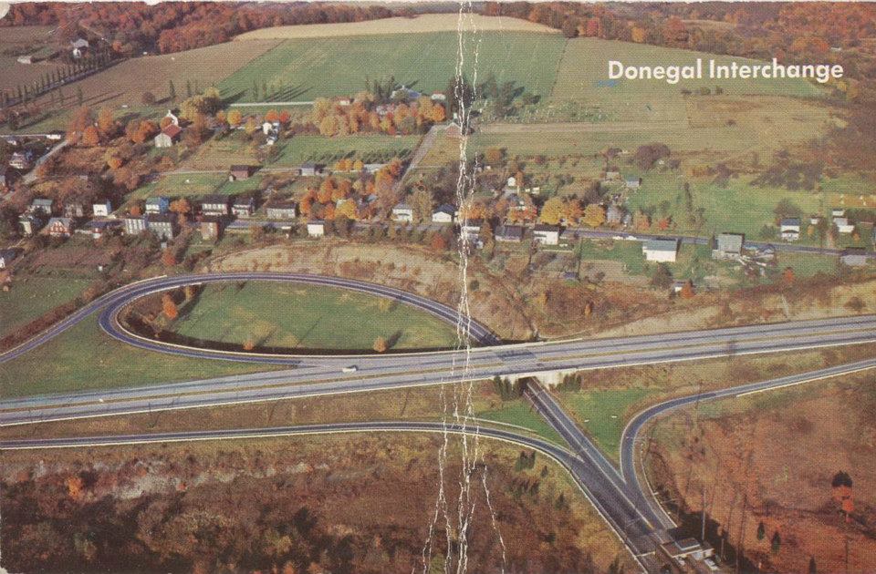
Donegal is a borough in Westmoreland County, Pennsylvania, United States. It is a distinct municipality from the adjacent Donegal Township. The population was 103 at the 2020 census. Donegal is best known as an exit on the Pennsylvania Turnpike with restaurants, gas stations, and two hotels for travelers.
It was named after the town and county of Donegal in Ireland.
Geography
Donegal is located at (40.111789, -79.381931).
According to the United States Census Bureau, the borough has a total area of 0.3 sqmi, all land.
Climate
|Jan record high F = 72 |Feb record high F = 75 |Mar record high F = 82 |Apr record high F = 90 |May record high F = 92 |Jun record high F = 95 |Jul record high F = 98 |Aug record high F = 98 |Sep record high F = 96 |Oct record high F = 86 |Nov record high F = 80 |Dec record high F = 74 |year record high F = 98 |Jan record low F = −22 |Feb record low F = −20 |Mar record low F = -13 |Apr record low F = 8 |May record low F = 16 |Jun record low F = 28 |Jul record low F = 35 |Aug record low F = 32 |Sep record low F = 22 |Oct record low F = 9 |Nov record low F = -6 |Dec record low F = −14 |year record low F = -22 | access-date = August 8, 2021}} | access-date = August 8, 2021}}
Demographics
As of the census of 2000, there were 165 people, 72 households, and 47 families residing in the borough. The population density was 519.1 PD/sqmi. There were 79 housing units at an average density of 248.5 /sqmi. The racial makeup of the borough was 98.79% White, and 1.21% from two or more races.
There were 72 households, out of which 26.4% had children under the age of 18 living with them, 54.2% were married couples living together, 9.7% had a female householder with no husband present, and 34.7% were non-families. 29.2% of all households were made up of individuals, and 9.7% had someone living alone who was 65 years of age or older. The average household size was 2.29 and the average family size was 2.83.
In the borough the population was spread out, with 21.8% under the age of 18, 10.3% from 18 to 24, 24.8% from 25 to 44, 27.3% from 45 to 64, and 15.8% who were 65 years of age or older. The median age was 41 years. For every 100 females, there were 81.3 males. For every 100 females age 18 and over, there were 81.7 males.
The median income for a household in the borough was $23,875, and the median income for a family was $25,417. Males had a median income of $32,000 versus $13,958 for females. The per capita income for the borough was $12,656. About 21.1% of families and 20.0% of the population were below the poverty line, including 18.9% of those under the age of eighteen and 17.1% of those 65 or over.
Education
Donegal has an elementary school for its children and for the children of several other area communities. As part of the Mount Pleasant Area School District, older students attend Mount Pleasant Area Junior/Senior High School.
Attractions
Donegal Township is home to a busy turnpike exchange that sees thousands of people every year. Most travelers are on their way to one of the many local attractions. Two of the main attractions are the 7 Springs Ski Resort and Hidden Valley Ski Resort. These resorts provide a steady winter income for many local businesses. There are also several Frank Lloyd Wright-designed homes within driving distance that can be toured, such as The Duncan House, Kentuck Knob, and Fallingwater. Fallingwater is located near Ohiopyle State Park, which offers a range of opportunities for outdoor recreation.

References
References
- "ArcGIS REST Services Directory". United States Census Bureau.
- "City and Town Population Totals: 2020—2021". US Census Bureau.
- Gannett, Henry. (1905). "The Origin of Certain Place Names in the United States". Govt. Print. Off..
- (2011-02-12). "US Gazetteer files: 2010, 2000, and 1990". [[United States Census Bureau]].
- "Census of Population and Housing". U.S. Census Bureau.
- "U.S. Census website". [[United States Census Bureau]].
- "Incorporated Places and Minor Civil Divisions Datasets: Subcounty Resident Population Estimates: April 1, 2010 to July 1, 2012". U.S. Census Bureau.
- "Census Population API". United States Census Bureau.
This article was imported from Wikipedia and is available under the Creative Commons Attribution-ShareAlike 4.0 License. Content has been adapted to SurfDoc format. Original contributors can be found on the article history page.
Ask Mako anything about Donegal, Pennsylvania — get instant answers, deeper analysis, and related topics.
Research with MakoFree with your Surf account
Create a free account to save articles, ask Mako questions, and organize your research.
Sign up freeThis content may have been generated or modified by AI. CloudSurf Software LLC is not responsible for the accuracy, completeness, or reliability of AI-generated content. Always verify important information from primary sources.
Report