From Surf Wiki (app.surf) — the open knowledge base
Ditton, Kent
Village in Kent, England

Village in Kent, England
| Field | Value |
|---|---|
| official_name | Ditton |
| country | England |
| region | South East England |
| static_image_name | Ditton Sign.jpg |
| static_image_width | 200 |
| static_image_alt | A photograph of a sign depicting an old church and ducks by a pond. The name of the village is shown above a row of flowers and fruit |
| static_image_caption | Ditton Village Sign |
| population | 4,786 |
| population_ref | (2011) |
| os_grid_reference | TQ 71038 58464 |
| london_distance_mi | 31 |
| london_direction | WNN |
| coordinates | |
| post_town | Aylesford |
| postcode_area | ME |
| postcode_district | ME20 |
| dial_code | 01732 |
| constituency_westminster | Chatham and Aylesford |
| civil_parish | Ditton |
| shire_district | Tonbridge and Malling |
| shire_county | Kent |
Ditton is a large village and civil parish in the borough of Tonbridge and Malling in Kent, England. The village is 4.6 mi west-northwest of Maidstone and 1.8 mi east of West Malling. The parish, which is long and narrow, straddles the A20 (the old Dover to London road), with farmland to the south and industry to the north. It lies in the Medway Valley, on the northern edge of the Kent Weald, and adjoins the ancient parishes of Larkfield, Aylesford and Barming. In 2011 it had a population of 4,786.
History
The origins of the village can be traced to the stream which runs through the parish and gave rise to many corn mills along its length. The earliest recorded mention of the village is in the Domesday Book of 1086. The village contains a number of listed buildings, which include a 12th-century church, an old mill house, and two oast houses.
More recently, ragstone and newsprint industries have developed and become essential sources of local employment. The population of the village snowballed with the overspill of housing from the nearby town of Maidstone. Today Ditton has a mixed agricultural and industrial economy, with a wide range of social and leisure facilities. In 2001 it had a population of 4,786.
|access-date=12 June 2011 |access-date = 12 June 2011 |url-status = dead |archive-url = https://web.archive.org/web/20110904201052/http://www.aylesford-newsprint.co.uk/ReportFiles/SHEF_2006.pdf |archive-date = 4 September 2011
Evidence of the early occupation of Ditton is scant. A Mesolithic tranchet axe, a sharpening flake, three microliths and 36 blades were found at Ditton, but the exact site of the find is now unknown.{{Citation |access-date = 27 June 2011 |access-date = 27 June 2011
An Anglo-Saxon spearhead was found in July 1962 by D. Tamkin in cutting through a natural knoll of sand on Messrs Reed's playing fields at Cobdown, Ditton. It is possible that the spearhead came from a grave on the top of the knoll, destroyed during the making or widening of the cutting.{{Citation |access-date = 27 June 2011 The first recorded mention of Ditton is in the Domesday Book, with an entry dated 1086. At that time the village had 31 dwellings.{{Citation |access-date=12 June 2011
There was another estate (manor) in the parish at that time called Sifletone, which also belonged to the Bishop of Baieux (Bayeux), and was entered into the Domesday Book: "Vitalis holds of the bishop (of Baieux) Sifletone. It was taxed at three yokes. The arable land is one carucate. In demesne, there is one carucate and a half, and six villeins, with one borderer, having half a carucate. There are six servants, and one mill of 10s. There are ten acres of meadow and thirty acres of pasture. In the time of the Confessor, it was worth 40 shillings when he received it four pounds, now 100 shillings. In the time of king Edward the Confessor, two men, Leuuin and Uluuin, held this land in coparcenary, and could turn themselves over with this land to whomever they would."
Thus there were three manors within the parish; Ditton Manor, with the appendant Brampton Manor, and Sifletone, all of which were owned by the Bishop of Bayeux at this time. The Bishop of Bayeaux was Odo, Earl of Kent, half brother of William the Conqueror. In 1082, after it was discovered that Odo planned a military expedition to Italy, he was imprisoned, and his estates (including Ditton, Brampton, and Sifletone) were confiscated to the Crown.{{Citation |access-date = 16 July 2011 |access-date=17 July 2011

Ditton has a ford which, along with St Peter's Ad Vincula's Church, is situated in a conservation area on the west of a large green. The church is dated to the 12th century with a later 14th-century tower, and the first bell of Ditton church was hung there in 1656. Ditton parish register has as its opening words, "The Register book of Ditton beginning Anno Dom. 1663. William Jole, rector, inducted Rector of Ditton, 1st August, Anno Dom. 1663." Also at the commencement, it is recorded, on 1 August 1711, that every acre of woodland in the parish of Ditton by immemorial custom pays tithe to the rector.{{Citation |access-date=16 July 2011}}
The north nave window has fragments of 14th-century glass, and the nave has a good selection of hanging wall monuments and a benefactions board. A lead plaque on the nave wall, removed from the tower roof in 1859, has a picture of a ship from Nelson's time scratched on it.{{Citation |access-date=14 June 2011}} The mill that was recorded in the Domesday Book, Church Mill, was located close to the ford and closed down around 1912.
In 1798 the parish was described in the following terms: "The high road from London, through Wrotham, to Maidstone, crosses the middle of it, at the thirty-first milestone; the village stands on it, and the church about a quarter of a mile further southward, on an ascent, beyond which, the parish reaches into the large tract of coppice woods, which extends as far as Teston and Barming. The stream from Bradborne Park runs through this parish and village, across the above road, and having turned two mills, one above and the other below it, runs on to the River Medway, which is the northern boundary of this parish, near the north-west extremity of which, on the road leading from Larkfield to Newhith, and not far distant from that hamlet and the river, is Borough Court. This parish is rather an obscure place, and has nothing further worthy of notice in it."
The three manors (estates) of Ditton, Brampton, and Sifletone were back in common ownership in the reign of Henry VII, when they belonged to "Thomas Leigh of Sibton in Liminge". The subsequent history of the manors is as follows:


The manor of Ditton included a mansion called Ditton Place, not to be confused with Ditton Court. Ditton Place was built in the late 16th century by the Brewer family and stood on the site now occupied by Troutbeck House.{{Citation |access-date=16 July 2011 |url-status=dead |archive-url=https://web.archive.org/web/20120430134621/http://www.old-maps.co.uk/maps.html |archive-date=30 April 2012 |access-date = 14 June 2011 |url-status = dead |archive-url = https://web.archive.org/web/20120319212430/http://www.npor.org.uk/Reporter/oct03/g1003.htm |archive-date = 19 March 2012 |access-date=16 July 2011
Ditton Court was located just to the west of St Peter's Church. Court is a term used widely in Kent in place of manor. Ditton Court was the seat of the Lord of the Manor of Ditton, but over the centuries most holders of the manor were possessed of landholdings elsewhere and held Ditton in absentia. When the lord was in attendance, it was often to preside over the manorial court, which decided local issues relating to land tenure, services owed to the lord by his tenants, and even petty crime. Ditton Court was demolished in 1972 to make way for a modern housing development that bears its name.
Brampton Manor probably stood on the site of the New Road Industrial Estate. After the manor was destroyed the site was known as Brampton Field, at least until the 18th century, and indeed one of the streets of the housing estate which covers the site today is named Brampton Field.{{Citation |access-date=14 June 2011
Sifflington Manor (Sifletone) was an estate within Ditton parish and appeared to have been incorporated into Ditton Manor at some stage before the 19th century.
.JPG)
A manor house, Borough Court (also known as Brooke Court), stood in the northernmost part of the parish; though it no longer exists it probably stood in the vicinity of the modern Aylesford Newsprint site. The Culpepper family of Aylesford owned the house during the reign of King Edward III (1327–1377). The High Sheriff of Kent in 1426–27, Walter Culpeper, was the owner until the house devolved onto his heirs, eventually passing to Richard Culpeper (later Sir Richard Culpepper) who also owned the manor house at Oxon Hoath. Sir Richard Culpepper died in 1484 without issue, and the house was divided amongst his three daughters, one of whom was Joyce Culpeper—whose daughter was Catherine Howard and would become the fifth wife of King Henry VIII. The house was then sold to Francis Shakerly who hailed from Shakerly, Kent.{{Citation |access-date = 14 June 2011 |url-status = dead |archive-url = https://web.archive.org/web/20110928001239/http://gen.culpepper.com/archives/uk/places/ditton.htm |archive-date = 28 September 2011
Notable people
- William Kempe, the parson of Ditton, was sued for £80 in 1534 for being absent from his parish and for taking a stipend for saying prayers for the souls of the dead (which was prohibited by a statute of 1529). Although Kempe admitted being absent, he claimed that he was chaplain to Baron John Zouche and thus entitled to receive two benefices.{{Citation |url=https://books.google.com/books?id=5TnQiAsgcdwC&dq=Ditton%2C+Kent&pg=PA201|title= Selling the Church: the English Parish in Law, Commerce, and Religion, 1350–1550 |access-date=14 June 2011|isbn= 9780807827437

- The Rev. John Young Stratton (1829/30 – 1905) was an author, essayist, social reformer, campaigner against rural poverty, and Rector of Ditton for 48 years. He is now remembered chiefly for his tireless campaigning to improve the lives of farm labourers and hop-pickers. In terms of the latter, the remaining hopper huts across Kent and further afield are a testament to his legacy. In 1868, he advocated for a system of national insurance to be administered through the Post Office, which closely resembles the modern welfare state. A highly respected figure, his obituary referred to him as “probably the best known clergyman in Mid-Kent” and “the Hoppers’ friend”. John Stratton was also responsible for the restoration and alteration of St Peter’s Church in 1860, under the supervision of Sir (George) Gilbert Scott.
- William Boghurst was an apothecary, and native, of Ditton, who remained in London during the Great Plague of 1665. During the plague, his medical practice expanded and he made his name. He stayed in the city throughout the epidemic, treating by his own account "40, 50 or 60 patients a day". By the end of the year his reputation was sufficient to attract offers from the corporation of Norwich, which tried to employ him when the infection reached there. He wrote a book about his experience which, although not printed at the time, was subsequently published in 1894 for the Epidemiological Society of London under the title Loimographia: an Account of the Great Plague of London in the year 1665.{{Citation |access-date=15 June 2011}} In later life his fortunes appear to have declined, as he could not afford the livery of his company in 1682. Boghurst died on 2 September 1685 aged 54 and was conveyed from London to be buried in the churchyard at Ditton.

-
Thomas Tilson was the rector of Ditton from 1679 to 1702 and was in correspondence with the Protestant cleric Richard Baxter. In one letter Tilson described how a woman from Rochester had gone to her father's house in West Malling where she died on 4 June 1691. While on her death bed, at two o'clock in the morning, she appeared as an apparition to a nurse in Rochester, some nine miles away, where her children were being looked after. It had been the dying woman's wish to see her children before she died, but she had been persuaded not to travel because of her ill health. Baxter included this account in his subsequent book The Certainty of the Worlds of the Spirits published in the same year.{{Citation |access-date=15 June 2011|isbn= 9780198185833 |access-date=16 July 2011|year=1798
-
Reverend Samuel Bishop (1731–95) was a poet, headmaster of Merchant Taylors' school and rector of Ditton. His posthumously published book entitled Poems (1796) was much admired and several times reprinted.{{Citation |access-date = 15 June 2011 |url-status = dead |archive-url = https://web.archive.org/web/20120315131346/http://spenserians.cath.vt.edu/authorrecord.php?action=GET&recordid=33134 |archive-date = 15 March 2012 |access-date= 24 June 2011 |archive-date= 15 March 2012 |archive-url= https://web.archive.org/web/20120315131337/http://spenserians.cath.vt.edu/CommentRecord.php?action=GET&cmmtid=9156 |url-status= dead

-
Thomas Golding, sheriff of Kent in 1703, was living in the nearby parish of Leybourne when he acquired Ditton Place in 1701. He had been the mortgagee of Thomas Brewer in respect of a number of properties when the latter defaulted. His arms were "argent, a cross voided between four lions passant, guardant gules" (a red hollow cross between four lions lying down with their heads and front paws up, on a white or silver background). He left Ditton Place to his nephew, another Thomas, who seems to have sold it and then repurchased it around 1735.{{Citation |access-date=17 June 2011}} The surname Golding is synonymous with a variety of hop known as Goldings and, although there has been some uncertainty as to who discovered the hop,{{Citation |access-date=15 June 2011}} evidence has more recently come to light suggesting it was almost certainly John GoldingJohn Golding (who died at Ditton place in 1807), the great-nephew of Thomas and the owner of Ditton Place.
-
Lt. Col. Clifford Sheldon, DSO, was joint managing and senior director of Reeds, the paper manufacturer, and was connected with that firm and its associated companies from 1911 until his death in 1950 at the age of 62 years. He gave his name to the Clifford Sheldon Club House, a converted oast house, which subsequently became the Manor and Greenside Oast.{{Citation |access-date=27 June 2011
-
Edward Humphreys, known as Punter Humphreys, who was born in Ditton in 1881, was an English professional cricketer who played first-class cricket for Kent County Cricket Club between 1899 and 1920. He played nearly 400 first-class matches and coached cricket after his retirement.
-
Charles Hooman, often known as Chubby Holman, was born in Ditton in 1887. He was an English amateur sportsman who played cricket for Oxford University and Kent County Cricket Club between 1907 and 1910. He won Blues for golf, rackets and cricket and later represented the Great Britain and Ireland golf team in the Walker Cup in 1922 and 1923. He served in the Royal Naval Reserve during World War I and the RAF Volunteer Reserve during World War II.
-
Barry Hawkins (born 23 April 1979) is an English professional snooker player from Ditton. He turned professional in 1996, rising to prominence in the 2004–05 snooker season, when he reached the last 16 of the 2004 UK Championship, the quarter-finals of the 2004 British Open, and the semi-finals of the 2005 Welsh Open. He has now spent twelve successive seasons ranked inside the top 32. He reached his first ranking final and won his first ranking title at the 2012 Australian Goldfields Open.
-
Simon Webley, the Anglican economist, research director of the Institute of Business Ethics, and former board member of the Centre for Policy Studies, is a long-term resident of the village.
-
Dr Daniel Morris (born 1970), scientist, specialising in synthetic polymers, was brought up in the village.
Turnpike

The current A20, which runs through the village, was once a turnpike, probably established between 1780 and 1820 to connect London with Dover. The Turnpike Act 1744 required that turnpike trusts set up milestones along these roads. A series of mileposts made in cast-iron appear on the stretch of road between Aylesford and Addington; at Ditton, Larkfield, and Ryarsh. The one at Larkfield is shown on an 1862 Ordnance Survey map, and the Ditton post is shown on a similar map of 1869. Both the Larkfield and Ditton posts are classed as Class II listed buildings.{{Citation |access-date=26 June 2011}}
Population
In 1663 the population was recorded as 218.{{Citation |access-date=14 June 2011|isbn=9780806303161 |access-date=14 June 2011}} containing 192 inhabitants." In 1851 the population was 235{{Citation |access-date=14 June 2011 |access-date=14 June 2011
Education
The Ditton Church School was founded in 1853 as a place of education for 70 children, and enlarged in 1887 by the Brassey family for Jubilee of Queen Victoria.{{Citation |archive-url=https://web.archive.org/web/20120302204550/http://www.bbc.co.uk/history/domesday/dblock/GB-568000-156000/page/7 |url-status=dead |archive-date=2 March 2012 |access-date=14 June 2011 |archive-url=https://web.archive.org/web/20120302203625/http://www.bbc.co.uk/history/domesday/dblock/GB-568000-156000/page/2 |url-status=dead |archive-date=2 March 2012 |access-date=14 June 2011
Ditton Infant School today caters for boys and girls from 4 to 7 years of age{{Citation |access-date=26 June 2011 |access-date=10 September 2015

Ditton Church of England Junior School is a primary school catering for mixed pupils aged 5–11 and is adjacent to the infant school. In 2008 there were 277 children on the school roll{{Citation |access-date = 26 June 2011 |url-status = dead |archive-url = https://web.archive.org/web/20110726174232/http://www.ditton-jun.kent.sch.uk/default_files/Page1690.htm |archive-date = 26 July 2011 |access-date = 26 June 2011
Aylesford School – Sports College is a secondary school situated in Teapot Lane, Aylesford, in modern buildings. Its catchment area is to the western side of Maidstone and includes pupils from Ditton. The school is for mixed gender pupils in years 7 to 11, with the sixth form for those in years 12 and 13. In 2004 the school gained specialist status as a Sports College, with the result that the curriculum now includes an element of sports education of every aspect. In 2010 there were 944 pupils on the school roll, and it was inspected by Ofsted in the same year.{{Citation |access-date = 26 June 2011
MidKent College (formerly Mid-Kent College of Higher and Further Education) is the nearest further education college to Ditton. Three campuses, situated in Maidstone and Medway, cater for around 15,000 students aged 16+. The courses offered cover many vocational and academic subjects starting with pre-entry level and finishing at degree level.
Ditton Heritage Centre has been established within an old Victorian building in the village to teach children in the style of a Victorian school. The classroom has been fully restored to represent a typical classroom of the Victorian era.{{Citation |access-date=16 July 2011 |archive-date=30 March 2012 |archive-url=https://web.archive.org/web/20120330095655/http://www.ukattraction.com/south-east-england/ditton-heritage-centre.htm |url-status=dead
War memorial

|access-date=10 September 2015 The monument was designed by Gilbert Scott, who gifted the land the monument stands on to the village. It records the names of the military personnel who fell in the two world wars. Its design is unique among war memorials in the United Kingdom on account of the roof over the cross. The monument was dedicated and unveiled on 26 September 1920, in a ceremony attended by the Bishop of Rochester and General Archibald Murray. The monument was granted listed building status in 2000 as a result of Ditton Parish Council approaching the War Memorial Society for assistance to repair it.{{Citation |access-date=27 June 2011 |access-date=14 June 2011
Listed buildings in Ditton
- 40, The Stream, Ditton, Kent (Grade II)
- 578 London Road, Ditton, Kent (Grade II)
- Church of St Peter Ad Vincula New Road, Ditton, Kent (Grade II*)
- Golding Tomb 15 Yards South of Ditton Church (Grade II)
- Golding Tomb 20 Yards South East of the Chancel of Ditton Church (Grade II)
- Stream Cottages 44–48 (Grade II*)
- Milepost on the A20 London Road, Ditton, Kent
- The Clifford Sheldon Club House, Cobdown Close, Ditton, Kent (Grade II)
- The Old Mill House, 51 The Stream, Ditton, Kent (Grade II)
- War Memorial, 1 New Road, Ditton, Kent (Grade II){{Citation |access-date=30 June 2011}}
Geography
This history of Ditton has, in part, been shaped by the availability of natural resources in the area, especially water, soil, and rocks. Its position concerning transport links with London, notably the main roads and railways which tend towards the capital city, has also contributed to the village's development. Nowadays the parish is characterised by industrial units to the north, the middle by residential estates, and the south by fields and woodland.{{Citation |access-date=16 July 2011 |archive-date=29 November 2013 |archive-url=https://web.archive.org/web/20131129143647/http://getamap.ordnancesurvey.co.uk/getamap/frames.htm |url-status=dead
The parish of Ditton lies in the Medway valley and borders the River Medway to the north and the Weald to the south. The Medway is Kent's principal river and rises near East Grinstead in Sussex, flowing eastwards to Maidstone. After passing Ditton parish, it turns north and cuts through the North Downs at Rochester, joining the estuary of the River Thames as its final tributary near Sheerness. The Medway is some 112 km long.
The availability of water to transport products and raw materials, and as a resource used in the manufacture of paper, was essential to the historical development of paper mills in the area. Bradbourne stream, which meanders through the parish in a south-east to north-west direction, rises in East Malling, crosses under the A20 road and M20 motorway, and joins the river Medway near the Aylesford Newsprint site. Historically the availability of running water was essential to the early settlements that grew up in Kent, and to the establishment of industries in the area; such as providing power to drive the mills which ground grain.
Ditton is situated between the Lower Weald and the Chalk (North) Downs. The parish encompasses the Lower Greensand strata, where a formation of hard sandy limestone known as the Hythe Beds is abundant. From this formation ragstone is obtained. Kentish ragstone was a historically important building material in southeast England. The Romans used ragstone in the construction of London and villas in the south-east. Medieval builders used ragstone to build churches, civic buildings, houses and bridges over local rivers.{{Citation |access-date=25 June 2011 |access-date=16 July 2011
Governance
Chatham and Aylesford Parliamentary Constituency
Ditton is within the parliamentary constituency of Chatham and Aylesford. Since 4 July 2024 the Member of Parliament has been the Labour party's Tris Osborne. At the 2024 general election, Labour won by a majority of 1,998 with 33.5% of the vote in the constituency. Conservatives won 28.6% of the vote, Reform UK 24.5%, the Green Party 6.1%, and Liberal Democrats 5.3%.
Kent County Council
There are 84 elected councillors on Kent County Council of whom seven represent Tonbridge & Malling residents. The other members represent the remaining 11 councils in Kent. Tonbridge & Malling borough is divided into six county council divisions with each division having one councillor elected to represent it, except for the Tonbridge division which has two councillors. The county council division of Malling Rural North East includes Aylesford, Burham, Ditton and Wouldham.
Tonbridge and Malling Borough Council

Ditton Parish Council
Created in 1894 as a result of legislation requiring each parish to have its own council, the council presently consists of 13 members and is responsible for a variety aspects of parish life: the general upkeep and maintenance of two recreation grounds, the village green, War Memorial, Community Centre, parish allotments, and (in part) the churchyard. The council also funds floodlights to illuminate the church. A magazine, the Ditton Gazette, is published quarterly and is circulated among the households of the parish. In February 2006, the council was awarded Quality Parish Council status.{{Citation |access-date = 14 June 2011 |url-status = dead |archive-url = https://web.archive.org/web/20111017112016/http://www.dittonparishcouncil.gov.uk/council.htm |archive-date = 17 October 2011
Demography
| Ditton compared |
|---|
| 2011 UK census |
| Population |
| Non UK born |
| White |
| Asian |
| Black |
| Mixed |
| Christian |
| Muslim |
| Hindu |
| No religion |
| Unemployed |
| Retired |
At the 2011 UK census, the Ditton electoral ward had a population of 4,786. The ethnic breakdown was 96% white, 1.2% mixed race, 1.7% Asian, 0.6% black and 0.3% other. The place of birth of residents was 94.8% United Kingdom, 0.4% Republic of Ireland, 1% other 2001 EU member countries, 0.5% later EU accession countries and 3.2% elsewhere. Religion was recorded as 67.5% Christian, 0.3% Buddhist, 0.3% Hindu, 0.1% Sikh and 0.6% Muslim. 24.2% were recorded as having no religion, 0.3% had an alternative religion and 6.7% did not state their religion.
The economic activity of residents aged 16–74 was 43.4% in full-time employment, 15.6% in part-time employment, 9.2% self-employed, 2.5% unemployed, 2.5% students with jobs, 2.7% students without jobs, 16.9% retired, 3.7% looking after home or family, 2.6% permanently sick or disabled and 0.7% economically inactive for other reasons. The main industries for employed residents was 18.5% retail, 11.9% health and social work, 10.4% construction, 8.6% education and 7.9% manufacturing. Compared with national figures, the ward had a relatively high proportion of workers in construction and retail, and a relatively low proportion in hotels and restaurants. Of the ward's residents aged 16–74, 21% had a higher education qualification or the equivalent, compared with 27.4% nationwide.
Economy
The parish of Ditton contains a number of agricultural, small commercial and industrial businesses, marking a historical shift from a farming-based community to a modern, mixed economy.

|access-date = 25 June 2011 |url-status = dead |archive-url = https://web.archive.org/web/20120326025101/http://www.aylesford-newsprint.co.uk/ReportFiles/SHEF_2007.pdf |archive-date = 26 March 2012

|archive-url=https://web.archive.org/web/20120302205916/http://www.bbc.co.uk/history/domesday/dblock/GB-568000-156000/page/14 |url-status=dead |archive-date=2 March 2012 |access-date=25 June 2011}} As a result of research work carried out on the site, the station established a reputation as a world centre for the research of perennial crops. Horticultural Research International operated the site until 2009 until 1 April 2010, since when the East Malling Trust has owned the research station. The station is fully engaged with local business and contains a lecture hall that can take 200 delegates.{{Citation |access-date = 25 June 2011 |url-status = dead |archive-url = https://web.archive.org/web/20110426003858/http://www.emr.ac.uk/history.htm |archive-date = 26 April 2011 |access-date=25 June 2011

|access-date=17 July 2011}}
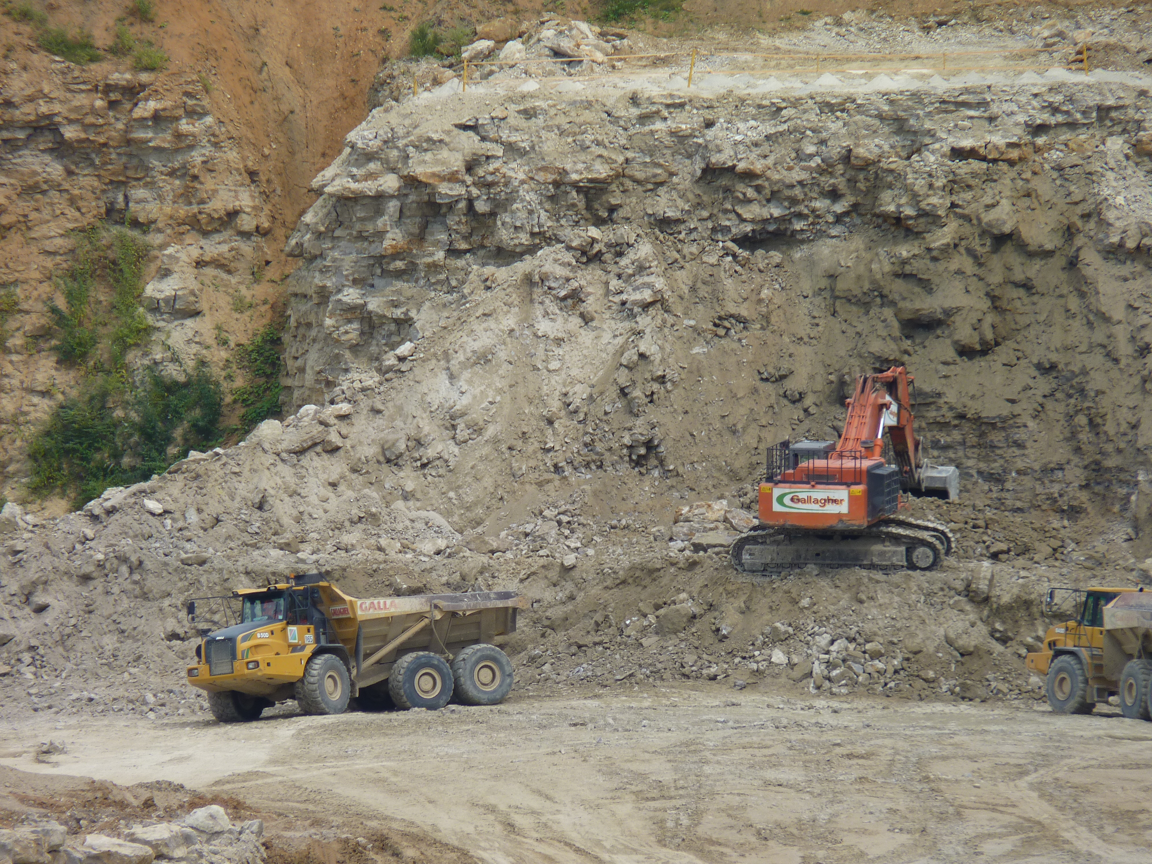
In 2011 Gallagher Aggregated applied to extend the Hermitage Quarry into Oaken Wood in the parish of Ditton. The planning committee of Kent County Council granted permission for quarrying in part of the woodland, but the decision was referred to the Secretary of State. Planning committee chairman Richard King said that "local residents and environmental groups have argued that the loss of irreplaceable ancient woodland and impact on the local wildlife site is unacceptable. On balance, however, members felt the job prospects and the economic need for ragstone to support construction in the county in future, and benefits of the project outweighed these objections."{{Citation |access-date=25 June 2011
Ditton is five miles from the centre of the county town of Maidstone, which is an important source of employment in the area.{{Citation |access-date = 17 July 2011 |url-status = dead |archive-url = https://web.archive.org/web/20110717051340/http://www.locateinmaidstone.co.uk/work/ |archive-date = 17 July 2011
Travel links
Many bus services pass through Ditton. There are two main frequent and reliable routes provided by Arriva Southern Counties.
The 71 Arriva service between Snodland and Maidstone Town Centre (via Allington) passes through Ditton every 10 minutes (Monday - Saturday) and every 30 minutes (Sunday). The sister 72 Arriva service between Kings Hill and Maidstone Town Centre also passes through Ditton every 30 minutes (Monday - Saturday).
The 703 Arriva service between Maidstone Town Centre and Bluewater Shopping Centre in Greenhithe, Dartford also passes through Ditton however this is an intermittent service that runs three times a day (Monday - Friday).
The nearest railway stations are at and ..
Ditton Nature Reserve

|access-date=14 June 2011 |archive-date=24 July 2011 |archive-url=https://web.archive.org/web/20110724021722/http://www.lnr.naturalengland.org.uk/Special/lnr/lnr_details.asp?C=23&N=Ditton&ID=1586 |url-status=dead
Many ragstone quarries have been abandoned and backfilled once exhausted. When Ditton Quarry closed down in 1984, quarrying operations had left behind a legacy of a lime-rich soil which formed the foundation of a thriving habitat for plants and wildlife; 140 wildflowers (including five that are rare in Kent), 18 butterfly species, and 50 bird species have been recorded. It is also home to foxes, rabbits, frogs, toads and newts. The quarry is now a Site of Nature Conservation Importance (SNCI). Public access is free.
The quarry is also a prime location for geological research and provides opportunities for field studies in a variety of disciplines: sedimentology, stratigraphy, palaeontology, geography, and industrial archaeology. Several features make this a unique location for the study of rock formations. Visitors can examine the extensively exposed rock faces, primarily Kentish Ragstone and Hassock facies, and study changes in vertical and lateral facies. The facies are glauconitic with some horizons of silicification. Shell debris (ammonites, belemnites, nautiloids, bivalves, etc.) and bioturbation are also present. The quarry could be important for future research via gamma ray profiling of the rock beds in relation to changes in sea level and climate.
References
References
- Fuller, Michael. (1980). "The Watermills of the East Malling and Wateringbury Streams". Christine Swift.
- Ditton - The Story of a Kentish Village, Alan Dodge, 2011, p.13
- Leasor, James, ''The Plague and the Fire'', House of Stratus (2001) pp. 45–7
- Suggestions for legislation relating to Friendly Societies, and for a system of insurances for the wage-paid classes by means of the Post Office, J Y Stratton, pub. William Ridgway, 1868
- Kent and Sussex Courier, 7 April 1905
- Paul Slack, ‘Boghurst, William (1630/31–1685)’, Oxford Dictionary of National Biography, Oxford University Press, 2004
- (1722). "A Journal of the Plague Year". [[Thomas Tegg and Son]].
- National Archives, Kew, Golding v Brewer. Reference C 8/360/84
- Kentish Weekly Post or Canterbury Journal, 20 November 1807
- Lewis P (2013) ''For Kent and Country'', pp.214–216. Brighton: Reveille Press.
- [https://cricketarchive.com/Archive/Players/21/21286/First-Class_Matches.html First-class matches played by Punter Humphreys], CricketArchive. Retrieved 2016-03-01.
- [http://www.espncricinfo.com/england/content/player/14934.html Charles Hooman], [[CricInfo]]. Retrieved 2017-03-10.
- Lewis P (2013) ''For Kent and Country'', pp.209–211. Brighton: Reveille Press.
- [http://www.worldsnooker.com/player_list-8265.htm World Snooker: Barry Hawkins] {{webarchive. link. (13 October 2009 - Official World Snooker profile.)
- https://patents.google.com/?inventor=Daniel+Morris
- Kelly's Directory of Kent, 1855
- [http://www.aosec.org.uk/page/mid-kent_college_higher_further_ed/59 The Association of South East Colleges website] {{webarchive. link. (4 December 2008)
- "Ditton Parish Council". Tob=nbridge and Malling Borough Council.
- Bowskill, Derek. "Map Of The River Medway".
- [http://www.environment-agency.gov.uk/homeandleisure/recreation/boating/31577.aspx Environmental Agency: River Medway] {{webarchive. link. (5 June 2011)
- Fuller & Spain. (1986). "Watermills (Kent and the Borders of Sussex)". Kent Archaeological Society.
- (2004). "An Historical Atlas of Kent". Phillimore & Co. Ltd..
- [https://www.bbc.co.uk/news/election/2024/uk/constituencies/E14001157 Chatham and Aylesford]
- "Kent County Council". Tonbridge and Malling Borough Council.
- "Election of Borough Councillors for Tonbridge & Malling". Tonbridge and Malling Borough Council.
- Neighbourhood Statistics. "Ethnicity". Neighbourhood.statistics.gov.uk.
- Neighbourhood Statistics. "Birthplace". Neighbourhood.statistics.gov.uk.
- Neighbourhood Statistics. "Religion". Neighbourhood.statistics.gov.uk.
- Neighbourhood Statistics. "Economic activity". Neighbourhood.statistics.gov.uk.
- Neighbourhood Statistics. "Industries". Neighbourhood.statistics.gov.uk.
- Neighbourhood Statistics. "Education". Neighbourhood.statistics.gov.uk.
- "Neighbourhood Statistics". Statistics.gov.uk.
- (24 February 2015). "Aylesford Newsprint closed with 233 jobs lost". Materials Recycling World.
- Kent Archives, Twisden Marriage Settlement 1667, Document #: U1515/T131
- The Watermills of the East Malling and Wateringbury Streams, Michael J. Fuller, 1980, p.60
- The origins of papermaking in Ditton, Kent, Richard Lowes, 2021
- Fuller, Michael (1980). The Watermills of the East Malling and Wateringbury Streams. Maidstone: Christine Swift. pp.1-4
- "Heritage Weekend 2013 - East Malling Research open day". Weeding the Web.
- ''New Scientist'', (no. 304) 13 September 1962, p. 568
- (13 November 2013). "Millwood Homes Begins Work at Ditton Laboratories".
- Graham, Mary. (13 July 2013). "Government approves application to extend Hermitage Quarry in Maidstone". Kentonline.co.uk.
- "Maidstone to Lunsford Park, Leybourne Park or Snodland".
- "Maidstone to Bluewater".
- ''Ditton Quarry Nature Reserve'', Ditton Gazette, Spring 2009.
- (June 2016). "Ditton Court Quarry". Kent RIGS.
- "Ditton Parish Council". Tonbridge and Malling Borough Council.
- "Ditton Community Centre". Ditton Parish Council.
- "Halls for Hire". Ditton Community Centre.
- "Ditton Village Clubs & Societies". Ditton Parish Council.
- "About Us". Cobdown Sports & Social Club.
This article was imported from Wikipedia and is available under the Creative Commons Attribution-ShareAlike 4.0 License. Content has been adapted to SurfDoc format. Original contributors can be found on the article history page.
Ask Mako anything about Ditton, Kent — get instant answers, deeper analysis, and related topics.
Research with MakoFree with your Surf account
Create a free account to save articles, ask Mako questions, and organize your research.
Sign up freeThis content may have been generated or modified by AI. CloudSurf Software LLC is not responsible for the accuracy, completeness, or reliability of AI-generated content. Always verify important information from primary sources.
Report
Social and leisure activities
Open spaces
Ditton has various urban open spaces: the New Road 4 acre recreation ground was acquired in 1954 and a second one measuring 11 acre was provided in the early 1970s, just prior to the building of the community centre (see Ditton Community Centre). A further 18 acre of recreational land was handed to the parish in 1991 following the cessation of quarrying at Ditton Court Quarry (see Ditton Nature Reserve). A small section of the land has been leased to Ditton Bowls Club who, with Sports Council grants and loans from the parish council, has provided a thriving member's club with a well kept green, looked after by parish council staff. The club has recently added a pavilion for use by its members.{{Citation |access-date=17 July 2011
Ditton Parish
Play areas for children and young people:
Outdoor Sports Facilities:
Amenity Green Spaces:
Natural and Semi-Natural Green Spaces:
Ditton Community Centre
In 1973 Ian Lavender (Pte. Pike of "Dads' Army") opened the centre, which was subsequently extended. Providing an important focal point for the local community, the centre has a hall capacity of up to 400 people. Other rooms include a meetings room and a functions room (up to 100 people). Activities throughout the week include: a playgroup & toddler club, keep fit class, badminton, table tennis and indoor bowls on weekdays; discos, dances, roller skating, indoor tennis and craft markets at the weekend. The centre also provides for sporting activities in its grounds: two tennis courts, two football pitches and a cricket pitch. There are showers and changing rooms inside the building. The centre is owned by Ditton Parish Council which holds regular meetings there.{{Citation |archive-url=https://archive.today/20130419172034/http://www.bbc.co.uk/history/domesday/dblock/GB-568000-156000/page/8 |url-status=dead |archive-date=19 April 2013 |access-date=14 June 2011
Cobdown Sports and Social Club
Kentish Quarryman
In 2008 the Kentish Quarryman Public House, which was the former Ditton Working Men's Club located on the western side of New Road, was opened. The house took its name from the historic connection of the parish with ragstone quarrying, which is acknowledged by a large slab of ragstone at its front entrance (see photograph). |access-date=17 July 2011 |archive-url=https://web.archive.org/web/20120327185103/http://www.kentishquarryman.co.uk/ |archive-date=27 March 2012 |url-status=dead |access-date = 17 July 2011
World Custard Pie Throwing Championship
In the 1980s, Ditton was home to the World Custard Pie Throwing Championship, after Councillor Mike Fitzgerald, who founded the championships, moved to Ditton from Coxheath, bringing the championships with him. Although the competition died out in 1988, it was revived at Coxheath in 2007, and it has been held there annually since then.{{Citation |access-date=16 June 2011