From Surf Wiki (app.surf) — the open knowledge base
Districts of Israel
none

none
| Field | Value |
|---|---|
| name | Districts of Israel |
| (Hebrew) | |
| مناطق اسرائيل (Arabic) | |
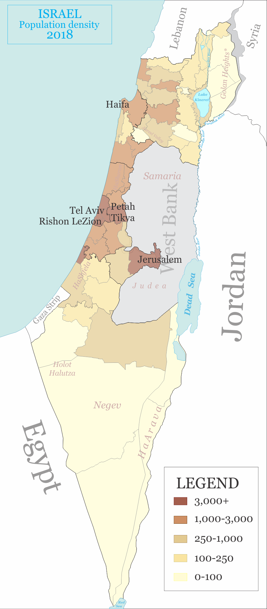
| map | |
| category | Unitary state |
| territory | State of Israel |
| current_number | 6 |
| population_range | 1,032,800 (Haifa) – 2,196,900 (Central District) |
| area_range | 72 sqmi (Tel Aviv) – 5477 sqmi (Southern District) |
| government | District government |
| subdivision | City council, Local council, Regional council |
(Hebrew) مناطق اسرائيل (Arabic)
There are six main administrative districts of Israel, known in Hebrew as **** (מְחוֹזוֹת; sing. מָחוֹז, ) and in Arabic as ****. There are also 15 subdistricts of Israel, known in Hebrew (נָפוֹת; sing. נָפָה, ) and in Arabic as . Each subdistrict is further divided into natural regions, which in turn are further divided into council-level divisions: whether they might be cities, municipalities, or regional councils.
The present division into districts was established in 1953, to replace the divisions inherited from the British Mandate. It has remained substantially the same ever since; a second proclamation of district boundaries issued in 1957—which remains in force as of 2023—only affirmed the existing boundaries in place.
The figures in this article are based on numbers from the Israeli Central Bureau of Statistics and so include all places under Israeli civilian rule including those Israeli-occupied territories where this is the case. Therefore, Golan Subdistrict and its four natural regions are included in the number of subdistricts and natural regions even though it is not recognized by the United Nations or the international community as Israeli territory. Similarly, the population figure below for the Jerusalem District was calculated including East Jerusalem whose annexation by Israel is similarly not recognized by the United Nations and the international community. The Judea and Samaria Area, however, is not included in the number of districts and subdistricts as Israel has not applied its civilian jurisdiction in that part of the West Bank.
Administration
The districts have no elected institutions of any kind, although they do possess councils composed of representatives of central government ministries and local authorities for planning and building purposes. Their administration is undertaken by a District Commissioner appointed by the Minister of the Interior. Each district also has a District Court.
Since the District Commissioners are considered part of the Ministry of the Interior's bureaucracy, they can only exercise functions falling within the purview of other ministries if the appropriate Minister authorizes them. This authorization is rarely granted, as other government ministries and institutions (for example, the Ministry of Health and the Police) establish their own divergent systems of districts.
Jerusalem District

Jerusalem District (, Mehoz Yerushalayim)
:Area: 653 km2 :Population (EoY 2018): 1,133,700 :District capital: Jerusalem.
Natural regions:
- 111 Judean Mountains
- 112 Judean Foothills
Northern District
Northern District (, Mehoz HaTzafon)
:Area: 4,473 km2 :Population (EoY 2018): 1,448,100 :District capital: Nof Hagalil
Subdistricts and natural regions:
- Safed (Tzfat) Subdistrictpopulation: 121,200
- 211 Hula Valley
- 212 Eastern Upper Galilee
- 213 Hazor Region
- 214 Central Lower Galilee
- Kinneret Subdistrictpopulation: 112,900
- 221 Kinerot
- 222 Eastern Lower Galilee
- Yizre'el Subdistrictpopulation: 520,100
- 231 Bet She’an Valley
- 232 Harod Valley
- 233 Kokhav Plateau
- 234 Yizre’el Valley
- 235 Yoqne'am Region
- 236 Menashe Plateau
- 237 Nazareth-Tir'an Mountains
- Akko Subdistrictpopulation: 643,300
- 241 Shefar’am Region
- 242 Karmi'el Region
- 243 Yehi'am Region
- 244 Elon Region
- 245 Nahariyya Region
- 246 Akko Region
- Golan Subdistrictpopulation: 50,600
- 291 Hermon Region
- 292 Northern Golan
- 293 Middle Golan
- 294 Southern Golan
Haifa District
Haifa District (, Mehoz Heifa)
:Area: 866 km2 :Population (EoY 2018): 1,032,800 :District capital: Haifa
Subdistricts and natural regions:
- Haifa Subdistrictpopulation: 583,400
- 311 Haifa Region
- Hadera Subdistrictpopulation: 449,300
- 321 Karmel Coast
- 322 Zikhron Ya’aqov Region
- 323 Alexander Mountain
- 324 Hadera Region
Central District
Central District (, Mehoz HaMerkaz)
:Area: 1,294 km2 :Population (EoY 2018): 2,196,100 :District capital: Ramla
Subdistricts and natural regions:
- HaSharon Subdistrictpopulation: 477,400
- 411 Western Sharon
- 412 Eastern Sharon
- Petah Tikva Subdistrictpopulation: 754,300
- 421 Southern Sharon
- 422 Petah Tikva Region
- Ramla Subdistrictpopulation: 351,700
- 431 Modi’in Region
- 432 Ramla Region
- Rehovot Subdistrictpopulation: 612,600
- 441 Rehovot Region
- 442 Rishon LeZiyyon Region
Tel Aviv District
Tel Aviv District (, Mehoz Tel Aviv)
:Area: 172 km2 :Population (EoY 2018): 1,427,200 :District capital: Tel Aviv
Natural regions:
- 511 Tel Aviv Region
- 512 Ramat Gan Region
- 513 Holon Region
Southern District
Southern District (, Mehoz HaDarom)
:Area: 14,185 km2 :Population (EoY 2018): 1,302,000 :District capital: Beersheba
Subdistricts and natural regions:
- Ashkelon Subdistrictpopulation: 551,200
- 611 Mal'akhi Region
- 612 Lakhish Region
- 613 Ashdod Region
- 614 Ashqelon Region
- Be'er Sheva Subdistrictpopulation: 750,700
- 621 Gerar Region
- 622 Besor Region
- 623 Be'er Sheva Region
- 624 Dead Sea Region
- 625 Arava Region
- 626 Northern Negev Mountain
- 627 Southern Negev Mountain
Formerly the Hof Aza Regional Council with a population of approx. 10,000 Israelis was a part of this district, but the Israeli communities that constituted it were evacuated when the disengagement plan was implemented on the Gaza Strip. Since the withdrawal, the Coordination and Liaison Administration operates there.
Judea and Samaria Area
Judea and Samaria Area (, Ezor Yehuda VeShomron)
:Area: 172 km2 :Israeli population (EoY 2018): 427,800 :Arab/Bedouin population: 40,000. (excludes Area A and Area B). :Largest city: Modi'in Illit
The name Judea and Samaria for this geographical area is based on terminology from the Hebrew Bible and other sources relating to ancient Israel and Judah/Judea. The territory has been under Israeli control since the 1967 Six-Day War but not annexed by Israel, pending negotiations regarding its status. It is part of historic Israel, which leads to politically contentious issues. However, it is not recognized as part of the State of Israel by the United Nations.
There are no subdistricts or administratively declared "natural regions" in the Judea and Samaria Area.
Notes
References
References
- [https://www.cbs.gov.il/he/publications/doclib/2021/atlas18_70/%D7%90%D7%98%D7%9C%D7%A1_70_%D7%90%D7%99%D7%9B%D7%95%D7%AA%2076.pdf Key to the Codes in the Maps - Districts, Sub-Districts and Natural Regions 2018], Israel Central Bureau of Statistics, 2021
- [https://www.cbs.gov.il/he/publications/doclib/2021/atlas18_70/%D7%90%D7%98%D7%9C%D7%A1_70_%D7%90%D7%99%D7%9B%D7%95%D7%AA%2078.pdf Districts, Sub-Districts and Natural Regions 2018], Israel Central Bureau of Statistics, 2021
- "Transfer of Power (District Commissioners and District Officers) Law, 5724-1964, Laws of the State of Israel vol. 18 no 38. (pp. 70-71)".
- "Polio Vaccination Centers across Israel".
- "Maps".
- (2019). "Localities and Population, by District, Sub-District, Religion and Population Group". [[Israel Central Bureau of Statistics]].
- (2016). "Statistical Abstract – Geography". [[Israel Central Bureau of Statistics]].
This article was imported from Wikipedia and is available under the Creative Commons Attribution-ShareAlike 4.0 License. Content has been adapted to SurfDoc format. Original contributors can be found on the article history page.
Ask Mako anything about Districts of Israel — get instant answers, deeper analysis, and related topics.
Research with MakoFree with your Surf account
Create a free account to save articles, ask Mako questions, and organize your research.
Sign up freeThis content may have been generated or modified by AI. CloudSurf Software LLC is not responsible for the accuracy, completeness, or reliability of AI-generated content. Always verify important information from primary sources.
Report