From Surf Wiki (app.surf) — the open knowledge base
Districts of Brunei
First-level administrative divisions of Brunei
First-level administrative divisions of Brunei
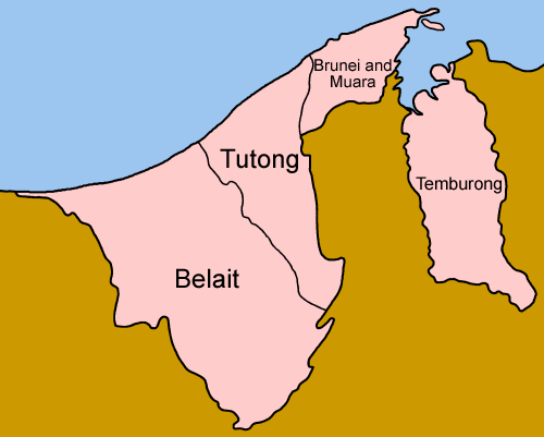
Districts () are the first-level administrative divisions of Brunei. The country is divided into four districts, namely Brunei-Muara, Belait, Tutong, and Temburong. Temburong is an exclave; it is physically separated from the three other districts by the Brunei Bay and the Malaysian state of Sarawak. Each district has a town as its administrative and economic centre, with the exception of Brunei-Muara, where the centre is Bandar Seri Begawan, a city and the country's capital.
History
The country previously had six districts, namely Brunei, Muara, Limau Manis (also known as Ulu Brunei), Tutong, Belait, and Temburong. Brunei and Limau Manis were merged in 1908, and the districts were restructured to form the present-day four districts in 1938.
Administration
Each district is administered by a district office (jabatan daerah), which is a government department under the Ministry of Home Affairs. The head of each department is a district officer (pegawai daerah) who is appointed by the government.
A district is further divided into mukims (townships), and subsequently each mukim consists of several villages (kampung). Each district office manages the mukims and villages within its district.
Districts
The four districts of Brunei are Brunei-Muara, Belait, Tutong, and Temburong. Temburong is an exclave of Brunei, separated by the Brunei Bay and the Malaysian state of Sarawak. Brunei-Muara is the smallest district by area but the largest by population, as it contains the national capital, Bandar Seri Begawan.
| District | Capital | Population | ||||||||
|---|---|---|---|---|---|---|---|---|---|---|
| (2016 census) | Area | |||||||||
| (km) | Area | |||||||||
| (sq mi) | Population | |||||||||
| density (km) | No. of | |||||||||
| mukims | Brunei-Muara | Belait | Tutong | Temburong | ||||||
| Bandar Seri Begawan | ||||||||||
| (also the capital of Brunei) | 289,630 | 571 | 571 km2 | 18 | ||||||
| Kuala Belait | 69,062 | 2,727 | 2727 km2 | 8 | ||||||
| Pekan Tutong | 48,313 | 1,166 | 1166 km2 | 8 | ||||||
| Pekan Bangar | 10,251 | 1,306 | 1306 km2 | 5 |
References
References
- Jabatan Muzium-Muzium Brunei. (2004). "Sungai Limau Manis: Tapak Arkeologi Abad Ke-10 – 13 Masihi". Jabatan Muzium-Muzium Brunei.
- "Brunei Darussalam". [[Government of Brunei]].
- "Brunei-Muara District". [[Government of Brunei]].
- "Department of Economic Planning and Statistics – Population". [[Government of Brunei]].
This article was imported from Wikipedia and is available under the Creative Commons Attribution-ShareAlike 4.0 License. Content has been adapted to SurfDoc format. Original contributors can be found on the article history page.
Ask Mako anything about Districts of Brunei — get instant answers, deeper analysis, and related topics.
Research with MakoFree with your Surf account
Create a free account to save articles, ask Mako questions, and organize your research.
Sign up freeThis content may have been generated or modified by AI. CloudSurf Software LLC is not responsible for the accuracy, completeness, or reliability of AI-generated content. Always verify important information from primary sources.
Report