From Surf Wiki (app.surf) — the open knowledge base
Diamond Ridge, Alaska

| Field | Value |
|---|---|
| official_name | Diamond Ridge, Alaska |
| native_name | Ch’aqiniggech’ |
| settlement_type | Census-designated place |
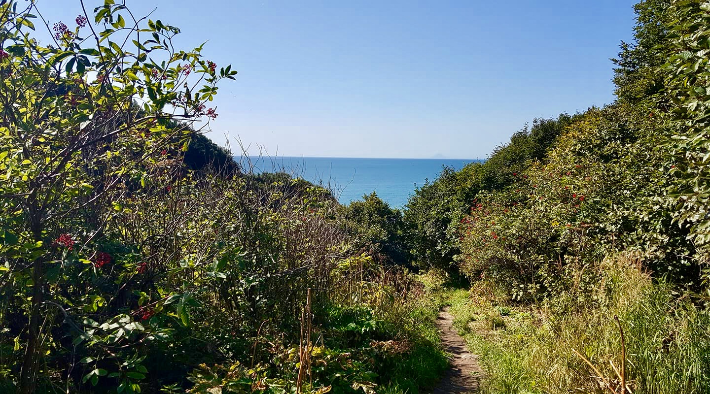
| image_skyline | Homesteadtraildiamondridge.jpg |
| image_caption | View from Diamond Ridge on the Homestead Trail, showing Kachemak Bay and the Kenai Mountains |
| image_map | Diamond_Ridge_Municipal_Map.png |
| map_caption | Location in Kenai Peninsula Borough, Alaska |
| subdivision_type | Country |
| subdivision_name | United States |
| subdivision_type1 | State |
| subdivision_name1 | Alaska |
| subdivision_type2 | Borough |
| subdivision_name2 | Kenai Peninsula |
| leader_title | Borough mayor |
| leader_name | Peter Micciche |
| leader_title1 | State senator |
| leader_name1 | Gary Stevens (R) |
| leader_title2 | State rep. |
| leader_name2 | Sarah Vance (R) |
| area_footnotes | |
| area_total_km2 | 109.81 |
| area_land_km2 | 109.81 |
| area_water_km2 | 0.00 |
| area_total_sq_mi | 42.40 |
| area_land_sq_mi | 42.40 |
| area_water_sq_mi | 0.00 |
| population_as_of | 2020 |
| population_total | 1330 |
| population_density_km2 | 12.11 |
| timezone | Alaska (AKST) |
| utc_offset | -9 |
| timezone_DST | AKDT |
| utc_offset_DST | -8 |
| elevation_m | 323 |
| elevation_ft | 1060 |
| coordinates | |
| area_code | 907 |
| blank_name | FIPS code |
| blank_info | 02-18925 |
| blank1_name | GNIS feature ID |
| blank1_info | 1865549 |
| unit_pref | Imperial |
| population_density_sq_mi | 31.37 |
Diamond Ridge (Dena'ina: Ch’aqiniggech’) is a census-designated place (CDP) just outside Homer in Kenai Peninsula Borough, Alaska, United States. At the 2010 census the population was 1,156, down from 1,802 in 2000.
Geography
Diamond Ridge is located at (59.665391, -151.570826) and is bordered to the south by the city of Homer and to the southeast by the city of Kachemak. To the east is the Fritz Creek CDP, while to the north and west is the Anchor Point CDP. The farthest west part of the Diamond Ridge CDP borders Cook Inlet at the mouth of Kachemak Bay.
The area is named for the high ground, Diamond Ridge, on which it sits. The ridge reaches an elevation of 1202 ft above sea level and is in the southern part of the CDP. Parallel landforms to the north are Crossman Ridge in the center of the CDP and a ridge connecting 1513 ft Ohlson Mountain and 1622 ft Lookout Mountain in the north. The terrain slopes north from the ridges to the Anchor River, which forms the northern boundary of the CDP.
According to the United States Census Bureau, the Diamond Ridge CDP has a total area of 109.8 km2, of which 0.01 km2, or 0.01%, are water. The main access is via Diamond Ridge Road, which runs across the top of the 5 mi ridge and connects to feeder roads on either side.
Demographics
|align-fn=center Diamond Ridge first appeared on the 2000 U.S. Census as a census-designated place (CDP).
As of the census of 2000, there were 1,802 people, 683 households, and 471 families residing in the CDP. The population density was 37.8 PD/sqmi. There were 850 housing units at an average density of 17.8 /mi2. The racial makeup of the CDP was 92.29% White, 0.11% Black or African American, 3.16% Native American, 0.44% Asian, 0.89% from other races, and 3.11% from two or more races. 2.11% of the population were Hispanic or Latino of any race.
There were 683 households, out of which 38.9% had children under the age of 18 living with them, 60.0% were married couples living together, 5.7% had a female householder with no husband present, and 31.0% were non-families. 24.0% of all households were made up of individuals, and 3.2% had someone living alone who was 65 years of age or older. The average household size was 2.60 and the average family size was 3.15.
In the CDP, the population was spread out, with 29.7% under the age of 18, 5.3% from 18 to 24, 30.5% from 25 to 44, 28.6% from 45 to 64, and 5.9% who were 65 years of age or older. The median age was 38 years. For every 100 females, there were 101.6 males. For every 100 females age 18 and over, there were 104.9 males.
The median income for a household in the CDP was $50,977, and the median income for a family was $61,813. Males had a median income of $51,964 versus $26,548 for females. The per capita income for the CDP was $23,864. About 7.9% of families and 7.9% of the population were below the poverty line, including 9.2% of those under age 18 and 4.8% of those age 65 or over.
Parks and trails

Diamond Ridge is home to two park areas with trail systems. One is the Homer Demonstration Forest, a preserve on the slopes just below the actual ridge itself. It contains an arboretum, self-guided nature trails, and is one end of the Homestead Trail which crosses the demonstration forest, climbs up Diamond Ridge and across a deep valley to Crossman Ridge, eventually ending at the Homer Reservoir. In winter months there are extensive groomed trails for cross-country skiing, as well as a snowshoe trail.
The other park in the area is the Diamond Creek State Recreation Area. This is a newer unit of Alaska State Parks and has little development. It is day-use only, camping is not permitted, and the access road is steep and extremely rough in places; vehicles over 25 ft are not permitted on the lower part of the road. The road leads to several parking areas for access to hiking and biking trails. The bike trails are constructed and maintained by a local cycling club.
References
References
- "2020 U.S. Gazetteer Files". United States Census Bureau.
- (April 2020}}{{cbignore). "Geographic Identifiers: 2010 Demographic Profile Data (G001): Diamond Ridge CDP, Alaska". U.S. Census Bureau, American Factfinder.
- (February 12, 2011). "US Gazetteer files: 2010, 2000, and 1990". [[United States Census Bureau]].
- {{gnis. 1412905
- "U.S. Decennial Census". Census.gov.
- "U.S. Census website". [[United States Census Bureau]].
- [http://www.homerswcd.org/demonstration-forest.htm Homer Demonstration Forest], Homer Soil and Water Conservation District
- [https://dnr.alaska.gov/commis/pic/releases/Join%20National%20Trails%20Day%20events%20June%202-3%20in%20Alaska%20State%20Parks.pdf Press release for Trails Day 2018], [[Alaska Department of Natural Resources]]
This article was imported from Wikipedia and is available under the Creative Commons Attribution-ShareAlike 4.0 License. Content has been adapted to SurfDoc format. Original contributors can be found on the article history page.
Ask Mako anything about Diamond Ridge, Alaska — get instant answers, deeper analysis, and related topics.
Research with MakoFree with your Surf account
Create a free account to save articles, ask Mako questions, and organize your research.
Sign up freeThis content may have been generated or modified by AI. CloudSurf Software LLC is not responsible for the accuracy, completeness, or reliability of AI-generated content. Always verify important information from primary sources.
Report